Mori Atlas logo
Nature reserveRéserve naturelle régionale du gouffre du Creux à Pépé

Mapping the protected Jura limestone sinkhole and vital chiroptera refuge in Bourgogne-Franche-Comté

Réserve naturelle régionale du gouffre du Creux à Pépé: Karst Geography and Bat Habitats

The Réserve naturelle régionale du gouffre du Creux à Pépé serves as a foundational protected landscape in the Jura foothills of Bourgogne-Franche-Comté. This small yet vital site focuses on the conservation of underground karstic galleries, which act as critical seasonal roosts for Schreiber's bent-winged bat and greater horseshoe bat populations. Beyond the sinkhole, the surrounding mosaic of dry calcareous grassland and woodland edge preserves significant botanical diversity and essential foraging corridors.

regional nature reservecave reservebat conservationchiropteralimestone karstsinkhole

Réserve naturelle régionale du gouffre du Creux à Pépé

Nature reserve

Park overview

Structured park overview, official facts, and landscape profile for Gouffre du Creux à Pépé Regional Nature Reserve

Gouffre du Creux à Pépé Regional Nature Reserve park facts, protected area profile, and essential visitor context

Review the core facts for Gouffre du Creux à Pépé Regional Nature Reserve, including designation, size, terrain, visitor scale, habitats, and operating context in one park-focused overview.

About Gouffre du Creux à Pépé Regional Nature Reserve

The Réserve naturelle régionale du gouffre du Creux à Pépé sits in the eastern foothills of the Jura range, on a slope overlooking the Doubs valley and the better-known Grotte d'Osselle downstream. The reserve is the surface expression of a much larger conservation strategy centred on a single natural sinkhole and its surroundings. Its modest 0.66-hectare footprint reflects the reality that, for this site, the protected resource is primarily subterranean: the cave system itself, with its galleries extending several metres into the limestone, and the bats that depend on it.

The reserve belongs to a regional network of cave-type reserves designed specifically to protect chiroptera, the ecological order that includes all bats. The reserve at the Creux à Pépé is not just a standalone site; it is a node in a carefully designed chain of underground refuges spread across Franche-Comté. The network allows bat populations to shift between hibernation, transit, and nursery roosts in response to weather, predation pressure, and human disturbance at any single location. Within this network, the Creux à Pépé plays a particularly strong transit role during spring, when large numbers of Schreiber's bent-winged bats move through the cave.

Above ground, the reserve protects a thin but ecologically rich mosaic. The sinkhole opens onto a dry calcareous grassland whose shallow soil and frequent rocky outcrops create conditions typical of the Jura's limestone pavement habitats. This grassland is bordered by a dense southern hedge that separates the reserve from surrounding agricultural meadows, effectively buffering bat flight paths and providing a controlled edge environment where woodland and open calcareous grassland meet. A botanical inventory carried out in 2019 by the Conservatoire botanique national de Franche-Comté recorded 103 vascular plant species across the reserve's surface area, including locally notable orchids and associations of community interest.

The reserve's significance is reinforced by its layered legal framework. In addition to its 2015 classification as a regional nature reserve, the site is covered by a biotope protection order (APPB), a ZNIEFF type I inventory record, and two separate Natura 2000 special area conservation designations. Together these instruments make the Creux à Pépé one of the most strictly protected small natural sites in the region, both above and below ground.

Quick facts and research context for Gouffre du Creux à Pépé Regional Nature Reserve

The Réserve naturelle régionale du gouffre du Creux à Pépé is a French regional nature reserve located in the Doubs department, in the Bourgogne-Franche-Comté region of eastern France. It covers an area of 0.66 hectares on the commune of Roset-Fluans, above the Grotte d'Osselle and the Doubs river valley.

The reserve is classified as IUCN Category IV (Habitat/Species Management Area) and is administratively identified as RNR293 in the national network of reserves. It was created on 24 September 2015 and is managed by the Commission de protection des eaux, du patrimoine, de l'environnement, du sous-sol et des chiroptères (CPEPESC) Franche-Comté. Its primary conservation purpose is the protection of a cave-rich limestone sinkhole used by commuting, hibernating, and breeding bats.

Protection and recognition

Documented terrestrial protection scope, management records, and verified designation data.

Protection Status and International Recognition for Réserve naturelle régionale du gouffre du Creux à Pépé

Terrestrial protection status, management scope, and official designation records for Réserve naturelle régionale du gouffre du Creux à Pépé remain cataloged through verified database entries. Structured facts compile documented conservation boundaries and international recognition frameworks without presumption of management outcomes.

Protection details

Protection scope
Terrestrial
Transboundary protection
No
WDPA ID
555597273
Park context

Deeper park guide and search-rich context for Gouffre du Creux à Pépé Regional Nature Reserve

Gouffre du Creux à Pépé Regional Nature Reserve history, landscape, wildlife, and travel context

Explore Gouffre du Creux à Pépé Regional Nature Reserve through its history, landscape character, ecosystems, wildlife, conservation priorities, cultural context, and seasonal travel timing in a structured park guide built for atlas discovery and search intent.

Why Gouffre du Creux à Pépé Regional Nature Reserve stands out

The reserve is best known for its role as a key seasonal bat roost within the regional network of cave-protected sites in Franche-Comté. The gouffre lies on the slope of a compact Jurassic limestone anticline and opens onto a system of natural underground galleries used by multiple bat species across the annual cycle. The site's greatest claim to ecological fame is its importance for Schreiber's bent-winged bat, one of the largest known spring transit colonies of this species in Franche-Comté, with close to two thousand individuals passing through the cave during the spring migration period. The cave also serves as a wintering site for the greater horseshoe bat, anchoring local recognition of the reserve as a cornerstone site for chiroptera conservation in the Jura foothills.
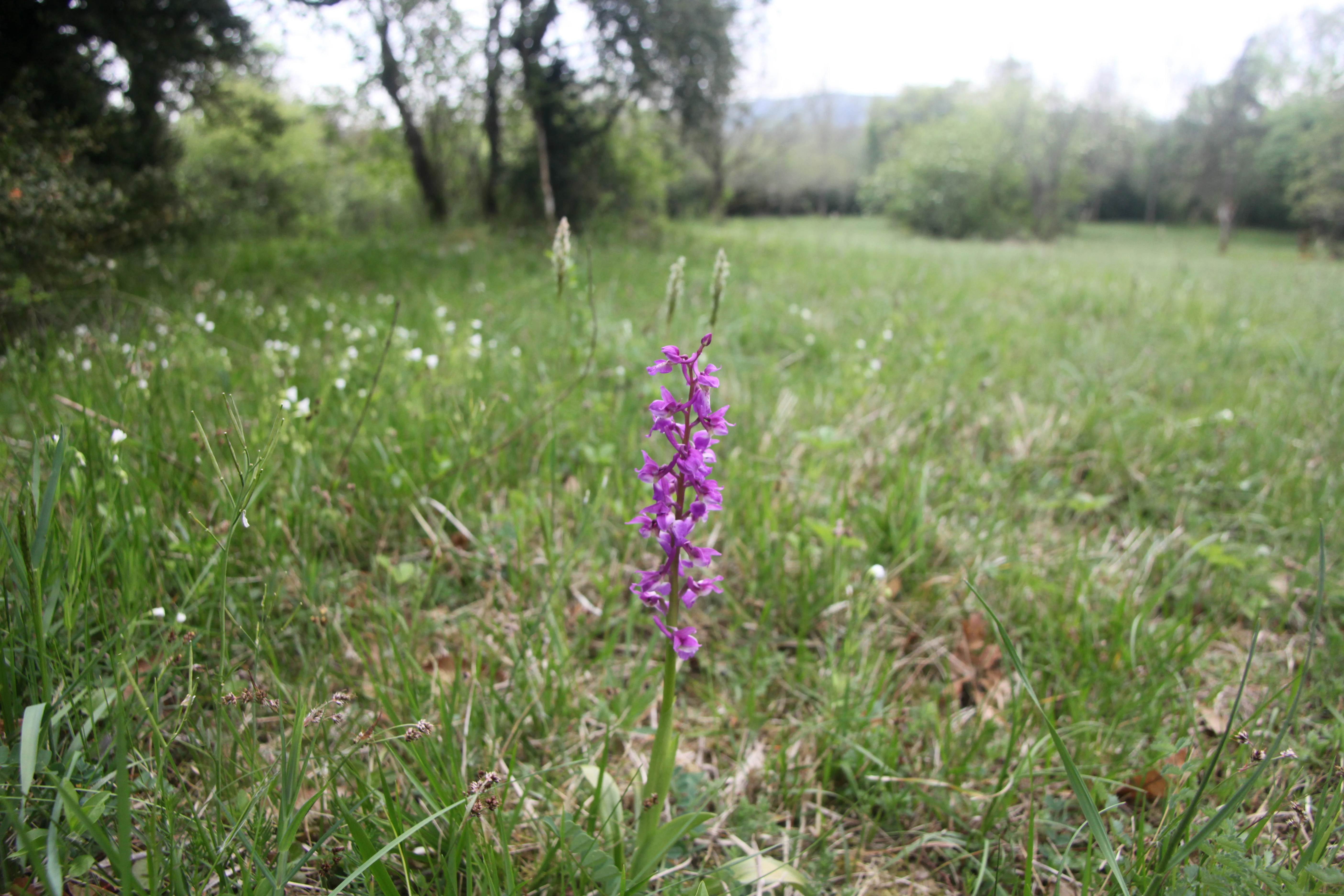
A single purple orchid in sharp focus stands in a grassy meadow with a blurred background of trees.
A vibrant purple orchid blooming in the grassland of the Creux a Pepe reserve.

Gouffre du Creux à Pépé Regional Nature Reserve history and protected-area timeline

The reserve's history is closely bound to a shift in French environmental law in the early 2000s. The 2002 "Démocratie de proximité" law transferred new competences to the regional level and caused the lapse of the voluntary nature reserve designation that several pre-existing bat caves had relied upon. Three sites of recognized importance for bats lost their protective status during this transition, creating an urgent conservation gap.

In response, CPEPESC Franche-Comté, working closely with the former Franche-Comté region, studied the feasibility of building a new regional network of reserves specifically dedicated to the protection of bats and their habitats. The outcome was the creation, between 2015 and 2017, of a network of seven regional nature reserves across the region, each centred on a cave system of recognized importance for chiroptera. The Réserve naturelle régionale du gouffre du Creux à Pépé was classified on 24 September 2015 as part of the first wave of this network.

CPEPESC Franche-Comté was formally designated as the manager of the network by prefectural and regional orders in October 2015 and December 2017. A unified management plan covering all reserves in the network was submitted to the regional scientific council for natural heritage and adopted unanimously by the permanent commission of the Bourgogne-Franche-Comté regional council on 27 September 2019. This plan set out nearly seventy actions focused on preserving the functionality of the cave roost network for six priority bat species over a five-year horizon.

Gouffre du Creux à Pépé Regional Nature Reserve landscape and geographic character

The Creux à Pépé lies on the western flank of a compact Jurassic limestone anticline, a typical structural feature of the Jura range. The host rock belongs to the Bathonian stage of the middle Jurassic and forms solid limestone beds in which karstic dissolution has opened the sinkhole and its associated gallery system. The cave extends several metres into the hillside as a series of natural underground passages.

Above ground, the landscape is unusually compact. The sinkhole opens onto a patch of dry calcareous grassland built on a very shallow stony soil interrupted by frequent rocky outcrops. The thin soils prohibit deep rooting and keep the sward low and herb-rich, a classic signature of Mesobromion-type limestone grasslands in the French Jura. To the south, a dense hedgerow screens the reserve from agricultural meadows on adjacent farmland, functionally restoring part of the original woodland edge that once separated cave openings from open farmland.

The broader setting is one of rolling limestone country south of the Doubs river. From the reserve's elevated position, the land drops toward the Doubs valley and the Grotte d'Osselle, giving the site a clear visual relationship with neighbouring karstic features. The reserve's elevation places it within the collinean to submontane zone of the Jura foothills, where the climatic conditions are cool and humid enough to support both beech woodland and the dry grassland facies of southern exposures.

Gouffre du Creux à Pépé Regional Nature Reserve ecosystems, habitats, and plant life

Ecologically, the reserve is best understood as a stack of overlapping habitats: a subterranean cave system, an above-ground calcareous grassland mosaic, and a woody edge boundary created by the southern hedgerow. These habitats are small but strongly differentiated, and each contributes to the reserve's conservation logic.

The botanical inventory completed in 2019 by the Conservatoire botanique national de Franche-Comté recorded 103 vascular plant species across the reserve. Among these, one species, the early purple orchid (Orchis mascula), is considered regionally noteworthy in Franche-Comté. Four distinct phytosociological associations were identified within the reserve's footprint, three of which are classed as community-interest habitats under European conservation frameworks: Mesobromion grasslands of the French Jura, beech woodlands with wood melick, and xerothermic woodland edges. The general typicity of these habitats is moderate, reflecting the gradual encroachment of woody species into the open calcareous sward.

Ecologically, the reserve functions less as an isolated patch and more as a step in a chain of bat-friendly caves. The dry grassland and hedge mosaic around the sinkhole provides foraging resources and acoustic navigation cover for bats moving into and out of the cave, while the cave itself offers a stable microclimate suited to hibernation and nursery colonies. This combination of underground and surface habitats within a single, tightly bounded reserve is the defining ecological signature of the site.

Gouffre du Creux à Pépé Regional Nature Reserve wildlife and species highlights

The reserve's wildlife interest is overwhelmingly focused on bats, for which it was specifically created. Seven bat species or species groups are currently recorded as using the cave. The most significant is Schreiber's bent-winged bat (Miniopterus schreibersii), a cave-dependent species of European conservation concern whose populations depend on networks of undisturbed underground roosts. The Creux à Pépé functions as a major spring transit site for this species, with approximately two thousand individuals recorded moving through the cave during the spring migration period, making it one of the largest known spring concentrations of the species in Franche-Comté.

The cave also serves as a hibernation site for the greater horseshoe bat (Rhinolophus ferrumequinum), a species highly sensitive to disturbance during winter roosting. The reserve's broader conservation planning covers six priority species across the network: Schreiber's bent-winged bat, the lesser mouse-eared bat (Myotis blythii), the Mediterranean horseshoe bat (Rhinolophus euryale), the greater horseshoe bat, the lesser horseshoe bat (Rhinolophus hipposideros), and Geoffroy's bat (Myotis emarginatus).

The 2019 management plan defines nearly seventy conservation actions across the network, ultimately aimed at preserving the ability of these species to use the cave at all stages of their annual cycle. Any disturbance to underground roosting bats can cause direct mortality or force colonies to relocate to less suitable sites, which is why human access to the cave is prohibited year-round.

Gouffre du Creux à Pépé Regional Nature Reserve conservation status and protection priorities

The Creux à Pépé is a conservation site of unusually high legal density for its size. Beyond its 2015 classification as a regional nature reserve, it carries a ZNIEFF type I designation (since 2014), two separate Natura 2000 special area conservation designations, and a biotope protection order (APPB). The reserve also sits adjacent to the RNR of the Grotte de Chenecey, another site in the same bat-focused network.

Its conservation logic is twofold. First, the site protects a discrete and ecologically essential piece of habitat: a single sinkhole and its associated cave, in a region where accessible underground roosts are scarce and easily disturbed. By subsuming the cavity permanently under multiple layers of protection, the reserve removes a recurring threat, the loss of protection through gaps between legal instruments, that had previously affected three important bat sites during the regulatory transition of 2002.

Second, the reserve's protection extends to the surface habitats that frame the cave entrance. The dry calcareous grassland, the beech-melick woodland patches, and the southern hedge form a functional foraging buffer around the roost, and each is recognized under European habitat conservation frameworks. The 2019 unified management plan for the network addresses not only cave microclimate and access control but also the long-term management of woodland structure, shrub encroachment, and the conservation of notable flora. Together, these layered instruments make the Creux à Pépé a model of how a very small site can carry outsized regional conservation value.

Gouffre du Creux à Pépé Regional Nature Reserve cultural meaning and human context

The Creux à Pépé is integrated into the karstic landscape identity of the Doubs valley, a region celebrated for its abundance of caves and sinkholes. The reserve lies just above the Grotte d'Osselle, one of the longest-known caves in the Jura and a landmark of regional natural heritage. This proximity places the Creux à Pépé within a broader cultural geography in which caves are both ecological treasures and elements of local identity, important to regional tourism, education, and natural history.

The reserve also exemplifies a specific chapter of modern French environmental culture: the transition of grassroots bat protection into formal regional conservation. The work of CPEPESC Franche-Comté, with regional government support, transformed a small number of locally important caves into a structured network of legally recognized reserves between 2015 and 2017. This model, driven by local expertise and citizen science traditions around chiroptera, is itself part of the cultural context of the site.

Top sights and standout views in Gouffre du Creux à Pépé Regional Nature Reserve

The reserve highlights itself through the combination of a very small footprint and a very large ecological role. Its underground system hosts one of the most important spring transit colonies of Schreiber's bent-winged bat in Franche-Comté, with about two thousand individuals moving through the cave each spring. The cave also supports a wintering population of the greater horseshoe bat, and is used across the annual cycle by six priority bat species across the broader network.

Its surface area is small but botanically rich: 103 vascular plant species, including a notable orchid, and three community-interest habitat associations within Mesobromion grassland, beech woodland, and xerothermic woodland edges. The site is layered under an unusually dense set of protection instruments, from regional nature reserve status to APPB and Natura 2000 designations, and is consistently regarded as one of the cornerstone sites for chiroptera conservation in the Jura foothills.

Best time to visit Gouffre du Creux à Pépé Regional Nature Reserve

The site's year-round restriction on public access to the cave rules out any form of cave-based wildlife encounter. That said, the surrounding limestone grassland and the broader Doubs valley landscape have a clear seasonal character. Spring is ecologically the most significant period here, marked by the mass transit of Schreiber's bent-winged bats through the cave and by the flowering of early orchid species on the dry calcareous sward, including the regionally notable Orchis mascula.

Late summer and early autumn illuminate the Mesobromion grassland as it dries, while winter brings quiet conditions in which the cave's bat hibernation populations settle in. For visitors interested in the regional bat conservation network rather than cave access, the most informative encounters typically occur through CPEPESC Franche-Comté's outreach programming and guided landscape tours of related sites in the Doubs and Jura foothills.

Monthly climate preview

Long-term annual temperature and precipitation rhythm across twelve measured months

Réserve naturelle régionale du gouffre du Creux à Pépé Climate Normals

Representative coordinates record measured multi-year temperature swings alongside steady daily precipitation patterns across each calendar month. Opening the full climate profile reveals complete monthly averages and detailed seasonal variation trends.
Annual mean10 °C
1 °C20 °C
Jan
Feb
Mar
Apr10°
May14°
Jun17°
Jul20°
Aug20°
Sep15°
Oct11°
Nov
Dec
Warmest month
July

19.6 °C

Coolest month
January

1.4 °C

Wettest month
November

3.5 mm/day

Driest month
March

2.4 mm/day

Park location guide

Geography guide, regional context, and park location map for Gouffre du Creux à Pépé Regional Nature Reserve

Gouffre du Creux à Pépé Regional Nature Reserve park geography, regions, and map view in France

Understand where Gouffre du Creux à Pépé Regional Nature Reserve sits in France through a broader geographic reading of the surrounding landscape, nearby location context, and its mapped position within the national park landscape.

How Gouffre du Creux à Pépé Regional Nature Reserve fits into France

France is a unitary semi-presidential republic and one of the world's largest economies. It borders Belgium, Luxembourg, Germany, Switzerland, Italy, Monaco, Andorra, and Spain, with a maritime border to the United Kingdom. The country is known for its cultural influence, art, cuisine, and political history spanning centuries.

Wider geography shaping Gouffre du Creux à Pépé Regional Nature Reserve in France

France is located in Western Europe. Metropolitan France extends from the Rhine to the Atlantic Ocean and from the Mediterranean Sea to the English Channel and North Sea. The country borders Belgium, Luxembourg, Germany, Switzerland, Italy, Monaco, Andorra, Spain, and has a maritime border with the United Kingdom.

Map view of Gouffre du Creux à Pépé Regional Nature Reserve

Use this park location map to pinpoint Gouffre du Creux à Pépé Regional Nature Reserve in France, understand its exact geographic position, and read its mapped placement within the surrounding landscape more clearly.

Pigeon | © OpenStreetMap contributors

Location context for Gouffre du Creux à Pépé Regional Nature Reserve

Bourgogne-Franche-Comté

Photographic records of limestone terrain, sinkhole formations, and protected grassland habitats

Visual Exploration of Réserve naturelle régionale du gouffre du Creux à Pépé Photos and Landscapes

Visual documentation reveals the limestone karst formations, dry calcareous grasslands, and subterranean gallery networks that define the protected landscape. Photographic reference materials illustrate the terrain and surface habitats supporting regional bat conservation across the Jura foothills.

A single purple orchid in sharp focus stands in a grassy meadow with a blurred background of trees.

Park atlas

Compare nearby limestone reserves, subterranean bat habitats, and regional protected landscapes

Parks Near Réserve Naturelle Régionale Du Gouffre Du Creux À Pépé And Surrounding Protected Areas

Browse other protected areas and regional nature reserves situated across the surrounding Jura limestone terrain. Discover adjacent conservation landscapes and compare related natural habitats beyond Réserve naturelle régionale du gouffre du Creux à Pépé.
Watercolor painting of a hilly landscape featuring green rolling hills, a rocky cliff formation to the right, and trees against a soft white background.
Nature reserveBourgogne-Franche-Comté
About 10 km away#1 closest

East

Réserve naturelle régionale des grottes de Chenecey: Protected Karst and Limestone Cliffs

Regional Nature Reserve in the Doubs, France

This nature reserve protects a diverse mosaic of habitats along the Loue valley. The site integrates surface calcareous grasslands with fragile underground cave galleries, providing critical refuge for rare bat species. It represents a significant conservation effort in the Jura region, mapping the intersection of subterranean voids and exposed limestone terrain.

Area
0.214 km²
Established
2017
IUCN
IV
Relief
Upland
A horizontal watercolor painting depicting a soft-edged, green-and-white landscape of rolling hills and distant limestone ridgelines.
Nature reserveBourgogne-Franche-Comté
About 21 km away#2 closest

East

Réserve naturelle nationale du ravin de Valbois: Protected Jura Blind Valley and Limestone Ravines

Geographic landscape exploration of the Doubs department's protected natural reserve.

Spanning 235 hectares, this protected nature reserve in Bourgogne-Franche-Comté preserves a textbook Jura reculée. The terrain showcases vertical limestone cliffs, deep forested ravines, and a 40-meter cascade. As a hotspot for butterfly diversity and Mediterranean-montane vegetation, the area offers a significant study in microclimatic gradients and old-growth forest conservation within the French landscape.

Area
2.35 km²
Established
1983
IUCN
IV
Relief
Mountain
Nature reserveBourgogne-Franche-Comté
About 21 km away#3 closest

North

Réserve naturelle régionale de la grotte de Beaumotte: Protected Karst and Cave Landscapes

A regional nature reserve focused on subterranean conservation.

Located in the Haute-Saône department, this regional nature reserve protects a critical limestone cave system that supports complex subterranean ecosystems and bat species of regional concern. The site occupies a modest surface area on the edge of the Monts de Gy massif, yet provides significant geological and ecological value through its horizontal gallery network and captured springs.

Area
0.088 km²
Established
2015
IUCN
IV
Relief
Upland
A soft watercolor painting of a green, hilly landscape with small groups of trees, set against a white background.
Nature reserveBourgogne-Franche-Comté
About 28 km away#4 closest

North

Réserve naturelle régionale du vallon de Fontenelay: Protected Area Atlas and Map

High-density marly grasslands and wetland seepage slopes

Situated in the Haute-Saône department, this nature reserve features a distinct valley landscape formed by marly soil and limestone. Explore the site's rich biodiversity including alkaline marshes and its significant role in the regional conservation network for northeastern France.

Area
0.416 km²
Established
2010
IUCN
IV
Relief
Upland
Wildlife reserveBourgogne-Franche-Comté
About 34 km away#5 closest

Southeast

Tourbières et lacs de la montagne jurassienne: Mapping High-Altitude Wetlands and Glacial Landscapes

A vast protected wildlife reserve in the Bourgogne-Franche-Comté region

Covering more than 12,000 hectares, this wildlife reserve forms a crucial conservation benchmark for peatland and glacial lake systems in the Jura Massif. The landscape encompasses deep combes, broad plateaus, and clear-water basins like Lac de Saint-Point, providing a vital habitat mosaic for diverse flora and fauna across the French highlands.

Area
121.56 km²
Established
2021
Relief
Mountain
Climate
Temperate
A horizontal watercolor painting depicting a soft, impressionistic landscape with rolling green hills, pale yellow fields, and a sparse line of trees against a white background.
Nature reserveBourgogne-Franche-Comté
About 35 km away#6 closest

South

Réserve naturelle régionale des grottes de la côte de la Baume, Jura Regional Nature Reserve

Karst caves and cliff-slope forest geography in France

Located in the Bourgogne-Franche-Comté region, this nature reserve protects a vital network of karst caves and unmanaged scree-slope ash forests. The site represents a specialized conservation effort centered on cliff-side habitats and underground sanctuaries within the Jura limestone landscape.

Area
0.054 km²
Established
2017
IUCN
IV
Relief
Upland
Nature reserveBourgogne-Franche-Comté
About 37 km away#7 closest

North

Réserve naturelle régionale de la grotte de la Baume noire Protected Area Map and Geography

Regional karst landscape in Bourgogne-Franche-Comté

This 19-hectare reserve in the Monts de Gy is defined by its Jurassic limestone geology and protected cave systems. The site remains a primary focal point for monitoring subterranean bat habitats and maintaining the ecological integrity of the surrounding deciduous forest landscape.

Area
0.191 km²
Established
2015
IUCN
IV
Relief
Upland
A watercolor illustration of a landscape with green forest, wetland grasses, and pale mountains in the background, set against a clean white background.
Nature reserveBourgogne-Franche-Comté
About 42 km away#8 closest

Southeast

Réserve naturelle régionale des tourbières de Frasne-Bouverans Protected Landscape Atlas

Peatland mosaic geography in the Drugeon valley of Bourgogne-Franche-Comté

Trace the boundaries and ecological features of this significant regional nature reserve. Spanning the Forbonnet massif and the wider Drugeon basin, the area features a dense concentration of raised bogs, woodlands, and mire habitats defined by complex glacial geology.

Area
2.926 km²
Established
1986
IUCN
IV
Visitors
17.5K annual

Common questions about visiting, size, designation, and location context for Gouffre du Creux à Pépé Regional Nature Reserve

Gouffre du Creux à Pépé Regional Nature Reserve FAQs for park facts, access, geography, and protected area context

Find quick answers about Gouffre du Creux à Pépé Regional Nature Reserve, including protected-area facts, park geography, trail and visitor context, and how the park fits into its surrounding country and regional landscape.
MoriAtlas Explorer

Continue Your Protected Areas Search Across the Global Atlas

Deepen your exploration by continuing the structured search for national parks and protected areas worldwide. Utilize the comprehensive filtering capabilities to compare different conservation landscapes and refine your understanding of global park geography. Discover more about the distribution and characteristics of protected natural areas.

Global natural geography