Mori Atlas logo
Nature reserveRéserve naturelle régionale de la Massonne

Mapping the ecological intersection of Brouage marshland meadows and Cadeuil acid heathland in western France

Réserve naturelle régionale de la Massonne: Analyzing the Protected Geography and Rare Ecosystem Transitions

(Réserve naturelle régionale de La Massonne)

Réserve naturelle régionale de la Massonne presents a distinct geographic study in ecosystem transition, concentrating two contrasting environments within a compact 200 hectare footprint in Charente-Maritime. This protected area bridges the gap between humid Brouage marshland meadows and sandy acid-loving heathland of the Cadeuil sector. Our atlas data details the spatial distribution of these habitats, providing a clear view of the territorial boundaries and the unique environmental conditions that sustain rare bat, butterfly, and dragonfly communities.

regional nature reservewet meadowscoastal marshlandacid heathlandbutterfliesdragonflies

Réserve naturelle régionale de la Massonne

Nature reserve

Park overview

Structured park overview, official facts, and landscape profile for Réserve naturelle régionale de la Massonne

Réserve naturelle régionale de la Massonne park facts, protected area profile, and essential visitor context

Review the core facts for Réserve naturelle régionale de la Massonne, including designation, size, terrain, visitor scale, habitats, and operating context in one park-focused overview.

About Réserve naturelle régionale de la Massonne

The Réserve naturelle régionale de la Massonne is a regional nature reserve in coastal western France, embedded in the famous Brouage marshlands of Charente-Maritime. Although small in absolute size, its position at the contact between two very different habitats: salt-influenced wet meadows and an inland sector of acid heathland, makes it ecologically far richer than its footprint might suggest. The reserve lies within the historic region of Saintonge and is administratively attached to the communes of La Gripperie-Saint-Symphorien and Saint-Sornin.

The protected area was first recognized under French law in 1997 as a voluntary nature reserve (réserve naturelle volontaire), an initiative driven by the private landowners who wished to safeguard the ecological value of their holdings. In 2012, it was reclassified as a regional nature reserve, again at the landowners' request, giving it stronger institutional protection. A further extension in 2025, decided by the regional council of Nouvelle-Aquitaine, brought the reserve's total area to roughly 200 hectares and added parcels owned by the Conservatoire du littoral, the Conservatoire d'espaces naturels, and additional private owners.

From an ecological standpoint, La Massonne is defined by contrast. On its western side, the reserve includes humid meadows characteristic of the Brouage marshlands, drained centuries ago but still shaped by their saline geological substrate. On the southern and eastern sides, the reserve extends into the acid soils that support calciphobous heathland vegetation of the Cadeuil type. The result is a remarkable concentration of habitats supporting more than 600 plant species, 28 of which are considered patrimonial, and a fauna that includes rare butterflies and dragonflies, amphibians such as the European pond turtle, the Dartford warbler, the European otter, and a notably rich bat community.

The reserve is also notable for its quietness. Designated as a zone of quiétude (tranquility zone), and partially overlapping with a Natura 2000 area, La Massonne provides a low-disturbance refuge for nocturnal wildlife. The absence of artificial light at night is a defining feature, making the site particularly valuable for bats that hunt insects in darkness. Public access is approached cautiously, with most visits organized as guided nature outings led by the reserve's managers and landowners. A short stretch of the GR 360 long-distance footpath, the Tour de Saintonge, crosses the reserve over roughly 650 meters.

Quick facts and research context for Réserve naturelle régionale de la Massonne

The Réserve naturelle régionale de la Massonne is a regional nature reserve (RNR) located in the Charente-Maritime department of the Nouvelle-Aquitaine region in western France, within the historic Saintonge region. Geographically it sits on the edge of the Brouage marshlands, on territory shared between the communes of La Gripperie-Saint-Symphorien and Saint-Sornin. The reserve is classified as IUCN Category IV, reflecting its focus on habitat and species management.

Its defining trait is the juxtaposition of two strongly contrasting ecosystems: wet meadows of the Brouage marshlands and acid heathland belonging to the Cadeuil sector. This mix supports more than 600 recorded plant species, including 28 of patrimonial interest, alongside rich invertebrate, amphibian, and bat faunas. The reserve is jointly managed by Nature Environnement 17 and the Ligue pour la protection des oiseaux, and partially falls within a Natura 2000 zone.

Protection and recognition

Documented terrestrial protection history, management scope, and international recognition details

Réserve naturelle régionale de la Massonne Protection Status and Designation Records

Territorial protection records for Réserve naturelle régionale de la Massonne outline the established designation timeline and management scope since 2012. Structured conservation tracking compiles verified protection status and official database identifiers for this regional nature reserve.

Protection details

Protection scope
Terrestrial
Designated year
2012
Transboundary protection
No
WDPA ID
555559615
Park context

Deeper park guide and search-rich context for Réserve naturelle régionale de la Massonne

Réserve naturelle régionale de la Massonne history, landscape, wildlife, and travel context

Explore Réserve naturelle régionale de la Massonne through its history, landscape character, ecosystems, wildlife, conservation priorities, cultural context, and seasonal travel timing in a structured park guide built for atlas discovery and search intent.

Why Réserve naturelle régionale de la Massonne stands out

La Massonne is especially known for the way it concentrates two sharply different ecosystems within a very small area: wet meadows of the Brouage marshlands on one hand, and calciphobous (acid-loving) heathland of the Cadeuil area on the other. This unusual ecological contact zone generates remarkable biodiversity in a compact reserve of roughly 200 hectares. The reserve is also widely noted for its exceptionally rich bat fauna, which includes 18 species, the great majority of those recorded in Charente-Maritime and a substantial share of those of Nouvelle-Aquitaine. The absence of artificial nighttime light makes the reserve a particularly favorable hunting ground for these nocturnal mammals. La Massonne is further appreciated for its populations of rare butterflies and dragonflies, alongside flagship species such as the European otter and the Dartford warbler.

Réserve naturelle régionale de la Massonne history and protected-area timeline

The landscape of La Massonne was shaped significantly during the great era of marsh drainage in the 17th and 18th centuries, when much of what is now the Brouage marshlands was converted into managed wet meadows. Despite this transformation, the area retained ecological qualities that eventually drew the attention of conservation-minded landowners.

In 1997, following approaches by the site owners, the territory was formally classified as a voluntary nature reserve (réserve naturelle volontaire), a French status that allows private landowners to commit their property to conservation under official recognition. This first classification laid the foundation for systematic protection and management, including late-season mowing and the use of draft horses for habitat maintenance.

In 2012, the site was reclassified as a regional nature reserve (réserve naturelle régionale), a stronger protection regime, again initiated by the owners. The new status provided a more durable legal framework and brought the reserve into the broader network of French regional nature reserves. A regional council deliberation in March 2025 extended the reserve's perimeter to about 202 hectares, integrating communal land, holdings of the Conservatoire du littoral and the Conservatoire d'espaces naturels, and additional private land. Today, the reserve is jointly managed by Nature Environnement 17 and the Ligue pour la protection des oiseaux (LPO), with the focal points of management being habitat preservation, low-disturbance wildlife protection, and ecological monitoring.

Réserve naturelle régionale de la Massonne landscape and geographic character

La Massonne is set in the flat, low-lying coastal landscape of the Brouage marshlands, a watery terrain shaped by centuries of human intervention and the saline geological history of the Atlantic coast. The western part of the reserve is dominated by wet meadows laid out on the drained marsh substrate, where subtle variations in salinity and water levels create a fine-grained mosaic of meadow and ditch habitats.

On the southern and eastern sides, the landscape shifts abruptly. Here, the reserve extends onto more acidic, sandy soils associated with the Cadeuil area, where vegetation transitions into open heathland. This calciphobous heath contrasts sharply with the marsh meadows: lower, drier, more shrubby, and dominated by distinctive acid-loving plant communities.

The combination gives the reserve an unusually compressed geography of contrasts. Within a few kilometers it is possible to walk from soft, open wetland pastures into darker, heather-dominated heath. Flat horizons, open skies, and the proximity of the Atlantic coast define the broader setting, with the historic Saintonge landscape extending inland behind the reserve.

Réserve naturelle régionale de la Massonne ecosystems, habitats, and plant life

Ecologically, La Massonne is best understood as a contact zone between two strongly contrasting ecosystems. The western half preserves the humid meadows of the Brouage marshlands, where late-season mowing and rotational ditch management maintain plant communities adapted to seasonal waterlogging and mild salinity.

The southern and eastern areas belong to the Cadeuil heathland complex, a fragment of the acid sandy heath habitats that were once more common along this part of the Atlantic coast. These heaths support calcifuge plant species not found in the wet meadows, creating a sharp ecological gradient within the reserve.

This juxtaposition is the main engine of the reserve's biodiversity. The combination of wetland margins, open heath, scrub, and patches of woodland, all within a small area, allows many species to coexist, including plants of patrimonial interest, rare invertebrates, amphibians tied to both wet and dry habitats, and mammal species that benefit from the unbroken ecological mosaic.

Réserve naturelle régionale de la Massonne wildlife and species highlights

The invertebrate fauna of La Massonne is a central part of the reserve's wildlife identity. At least 32 butterfly species have been recorded, including protected and rare taxa such as the marsh fritillary, and at least 27 dragonfly species, twelve of which are of patrimonial interest, including the Rosalia longhorn beetle. These insects benefit from the diversity of meadow, ditch, and heath habitats packed closely together.

Among vertebrates, the reserve hosts the European otter, a key indicator of wetland ecosystem health, and the Dartford warbler, a bird closely associated with Mediterranean and Atlantic heathland. The European pond turtle (Cistude) is also present, occupying the quieter wetland margins.

The most exceptional faunal feature of La Massonne, however, is its bat community. Eighteen bat species have been recorded, representing the great majority of those documented in Charente-Maritime and around 80 percent of the bat species known in Nouvelle-Aquitaine. The absence of artificial nighttime lighting across much of the reserve makes it a particularly favorable hunting ground, where bats can pursue insects without disturbance.

Réserve naturelle régionale de la Massonne conservation status and protection priorities

La Massonne's conservation significance lies in its ability to combine several otherwise fragmented habitat types within a small, well-managed territory. By protecting both Brouage wetland meadows and Cadeuil-type acid heathland in close proximity, the reserve safeguards an ecological transition that is increasingly rare in heavily modified coastal landscapes of western France.

The reserve's designation as a zone of quiétude (tranquility zone), along with partial overlap with a Natura 2000 area, underscores its role as a low-disturbance refuge for nocturnal and disturbance-sensitive species, particularly bats and breeding birds. The deliberate avoidance of artificial nighttime light is a central conservation tool, ensuring that the exceptional bat community can continue to hunt and roost without disruption.

Management combines traditional practices with modern ecological monitoring. Habitats are maintained through late-season mowing and by draft horses, a low-impact approach that preserves both meadow structure and the invertebrate communities that depend on it. Management is shared between Nature Environnement 17 and the LPO, an arrangement that brings together local conservation expertise and a national bird-protection organization.

Réserve naturelle régionale de la Massonne cultural meaning and human context

La Massonne lies within the historic landscape of Saintonge, a coastal and rural region of western France whose identity has long been tied to the marshlands of Brouage. The nearby fortified town of Brouage and the broader network of reclaimed coastal marshes mark a centuries-long history of human interaction with wet and saline terrain.

The reserve itself reflects a contemporary expression of this relationship: a protected area that emerged first from the initiative of private landowners and remains shaped by the cooperation between owners, local environmental associations, national NGOs such as the Ligue pour la protection des oiseaux, and public bodies including the Conservatoire du littoral and the Conservatoire d'espaces naturels. The continued use of draft horses for habitat management also ties the reserve to traditional rural working practices of the region.

Top sights and standout views in Réserve naturelle régionale de la Massonne

La Massonne packs a remarkable range of habitats into a small footprint, combining Brouage marshland wet meadows with Cadeuil-type acid heath. This unusual pairing supports more than 600 plant species, 28 of them of patrimonial interest, alongside rare butterflies and dragonflies.

The reserve is particularly notable for its bat fauna, with 18 species recorded and a design that minimizes artificial nighttime light, providing ideal feeding conditions. A short section of the GR 360 (Tour de Saintonge) also crosses the reserve, linking it to a wider regional network of long-distance paths.

Best time to visit Réserve naturelle régionale de la Massonne

Because La Massonne is primarily a low-disturbance nature reserve rather than a tourism site, visit timing is shaped mainly by ecological considerations rather than visitor infrastructure. The most biologically expressive seasons are late spring and early summer, when wet meadows are at their floristic peak and the heathland supports active invertebrate communities, including butterflies and dragonflies.

Late summer and early autumn are also periods of interest: this is when the reserve's traditional late-season mowing takes place, an event that itself shapes habitat structure. Visitors interested in bat wildlife may find late spring and summer evenings especially rewarding, when the reserve's dark skies offer favorable conditions for observing emerging and feeding bats. As a low-disturbance zone, visits are generally appropriate at any time of year when paired with quiet behavior and respect for the site's tranquility designation.

Monthly climate preview

Long-term representative point measurements tracking monthly temperature and precipitation cycles

Réserve naturelle régionale de la Massonne Climate Normals and Annual Weather Rhythm

Historical data records a measured annual temperature range from mean monthly lows near 7.46 °C to highs approaching 20.11 °C alongside varying daily precipitation rates across the coordinate. Accessing the complete monthly profile provides deeper analytical context for studying long-term meteorological patterns across the protected landscape.
Annual mean13 °C
7 °C20 °C
Jan
Feb
Mar
Apr12°
May15°
Jun18°
Jul20°
Aug20°
Sep18°
Oct15°
Nov11°
Dec
Warmest month
August

20.1 °C

Coolest month
February

7.5 °C

Wettest month
November

3.2 mm/day

Driest month
July

1.4 mm/day

Park location guide

Geography guide, regional context, and park location map for Réserve naturelle régionale de la Massonne

Réserve naturelle régionale de la Massonne park geography, regions, and map view in France

Understand where Réserve naturelle régionale de la Massonne sits in France through a broader geographic reading of the surrounding landscape, nearby location context, and its mapped position within the national park landscape.

How Réserve naturelle régionale de la Massonne fits into France

France is a unitary semi-presidential republic and one of the world's largest economies. It borders Belgium, Luxembourg, Germany, Switzerland, Italy, Monaco, Andorra, and Spain, with a maritime border to the United Kingdom. The country is known for its cultural influence, art, cuisine, and political history spanning centuries.

Wider geography shaping Réserve naturelle régionale de la Massonne in France

France is located in Western Europe. Metropolitan France extends from the Rhine to the Atlantic Ocean and from the Mediterranean Sea to the English Channel and North Sea. The country borders Belgium, Luxembourg, Germany, Switzerland, Italy, Monaco, Andorra, Spain, and has a maritime border with the United Kingdom.

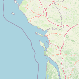
Map view of Réserve naturelle régionale de la Massonne

Use this park location map to pinpoint Réserve naturelle régionale de la Massonne in France, understand its exact geographic position, and read its mapped placement within the surrounding landscape more clearly.

Pigeon | © OpenStreetMap contributors

Location context for Réserve naturelle régionale de la Massonne

Nouvelle-Aquitaine
Park atlas

Compare adjacent marshlands, coastal terrain, and regional nature reserves

Parks Near Réserve Naturelle Régionale de la Massonne and Surrounding Protected Areas

Explore protected areas near Réserve naturelle régionale de la Massonne to examine connected wetland habitats and coastal marsh ecosystems. Comparing nearby reserves reveals broader regional biodiversity patterns and regional conservation networks.
Nature reserveNouvelle-Aquitaine
About 42 km away#1 closest

East

Vallée de l'Antenne: A Protected River Valley and Alluvial Landscape in Nouvelle-Aquitaine

Mapping riparian ecosystems and rare wetland habitats

Trace the course of the Antenne river as it meanders through a finely textured mosaic of ash and alder forests, poplar plantations, and floodplains. As a designated Natura 2000 site, this nature reserve acts as a critical refuge for biodiversity in western France, offering a textbook example of a low-energy river system that descends gently through the landscape of the Charente departments.

Area
12.08 km²
Established
1999
Relief
Lowland
Climate
Mediterranean
Wildlife reserveNouvelle-Aquitaine
About 64 km away#2 closest

Southeast

Terres d'oiseaux Wildlife Reserve: Protected Estuarine Landscape in Nouvelle-Aquitaine

Migratory bird habitat and Gironde estuary geography

Terres d'oiseaux is a significant wildlife reserve positioned within the Blayais marshes of Nouvelle-Aquitaine. The site encompasses a diverse mosaic of estuarine wetlands, including reedbeds and open water, providing critical stopover habitat for migratory birds along the Atlantic flyway. Its geography represents a blend of tidal interaction and controlled natural management, essential for regional avian monitoring and ecological studies.

Area
1.2 km²
Established
2010
IUCN
IV
Relief
Lowland
A horizontal watercolor painting depicting a winding river or lagoon flowing through rolling green hills and wetlands.
Nature reserveVendée
About 70 km away#3 closest

Northwest

Réserve naturelle nationale de la casse de la Belle-Henriette: Geography and Protection

Coastal lagoon and dune habitat atlas in Vendée

Covering a narrow strip of the Atlantic coast, Réserve naturelle nationale de la casse de la Belle-Henriette protects essential marine lagoon and saltmarsh habitats. This data set explores the reserve's shifting dune morphology and its significance as a migratory bird corridor within the broader coastal geography of the Pays de la Loire region.

Area
3.37 km²
Established
2011
IUCN
IV
Relief
Lowland
Nature reserveNouvelle-Aquitaine
About 70 km away#4 closest

Northeast

Réserve naturelle régionale du marais de Galuchet et des boucles de la Sèvre Niortaise Geography and Map

Urban protected wetland in the Nouvelle-Aquitaine region of France

This urban nature reserve protects 151 hectares of diverse wetland habitats along the Sèvre Niortaise. The landscape is defined by river meanders, wet meadows, and riparian corridors, making it a critical site for regional biodiversity and urban ecological connectivity in the Deux-Sèvres department.

Area
1.51 km²
Established
2025
IUCN
IV
Relief
Lowland
Watercolor painting of a wetland landscape featuring grassy banks, calm water, and soft rolling hills in the background.
Nature reservePays de la Loire
About 70 km away#5 closest

North

Réserve naturelle régionale du marais de la Vacherie: Protected Wetland Geography and Maps

Ecological mosaic of the Marais poitevin in Pays de la Loire

The Réserve naturelle régionale du marais de la Vacherie protects a high-quality fragment of historical marshland. Defined by flat terrain, winter-flooded depressions, and a complex system of drainage channels, the site serves as a crucial habitat for rare wetland flora and migratory waterbirds. This protected landscape offers insight into the sediment-rich, gently undulating terrain that characterizes the back-marsh zones of the Atlantic seaboard.

Area
1.81 km²
Established
2008
IUCN
IV
Relief
Lowland
Nature reservePays de la Loire
About 71 km away#6 closest

North

Réserve naturelle régionale du marais communal du Poiré-sur-Velluire Regional Nature Reserve

Mapping wetland biodiversity in the Pays de la Loire region

Spanning over 240 hectares of reclaimed marshland, this protected area stands as a unique ecological stronghold in France. The reserve demonstrates how traditional collective land management sustains a rich mosaic of freshwater and brackish habitats, supporting more than 177 bird species and heritage livestock breeds in an expansive, open terrain.

Area
2.41 km²
Established
2012
IUCN
IV
Scope
Terrestrial
Nature reservePays de la Loire
About 72 km away#7 closest

North

Réserve naturelle régionale de la ferme de Choisy: Marshland Protected Area and Regional Geography

Sub-brackish wet meadows of the Marais poitevin, Pays de la Loire.

Discover the unique ecological character of Réserve naturelle régionale de la ferme de Choisy, a vital wetland site in western France. This reserve showcases the intersection of traditional pastoral management and marshland conservation, hosting extensive bird populations and rare flora across its low-lying, reclaimed landscape.

Area
0.8 km²
Established
1991
IUCN
IV
Relief
Lowland
Protected areaNouvelle-Aquitaine
About 89 km away#8 closest

Southeast

Vallée de la Tude Protected Area: Regional Geography and Alluvial Landscape Map

Exploring the river valley networks of Nouvelle-Aquitaine

The Vallée de la Tude is a significant protected area located in the Charente department of southwestern France. This site features a series of wet meadows, lowland brooks, and woodland fragments that form an essential ecological network. Our atlas entry provides a detailed look at the geographic distribution and landscape composition of this unique alluvial valley.

Area
15.57 km²
Established
2006
Relief
Upland
Climate
Temperate

Common questions about visiting, size, designation, and location context for Réserve naturelle régionale de la Massonne

Réserve naturelle régionale de la Massonne FAQs for park facts, access, geography, and protected area context

Find quick answers about Réserve naturelle régionale de la Massonne, including protected-area facts, park geography, trail and visitor context, and how the park fits into its surrounding country and regional landscape.
MoriAtlas Explorer

Continue Your Protected Areas Search Across the Global Atlas

Deepen your exploration by continuing the structured search for national parks and protected areas worldwide. Utilize the comprehensive filtering capabilities to compare different conservation landscapes and refine your understanding of global park geography. Discover more about the distribution and characteristics of protected natural areas.

Global natural geography