
Mori Atlas logo
Nature reserveRéserve naturelle régionale des Isles du Drac

Understanding the braided Drac river corridor and its alluvial ecosystems within Auvergne-Rhône-Alpes

Réserve naturelle régionale des Isles du Drac: Mapped Geography and Protected Riverine Landscapes

Réserve naturelle régionale des Isles du Drac protects a distinctive fifteen-kilometer braided river stretch within the heavily humanized lower valley of the Drac. This regional natural reserve sustains a complex mosaic of shifting gravel bars, alluvial terraces, and riparian woodlands despite its proximity to industrial and urban infrastructure. The site functions as a critical ecological corridor in southeastern France, mapping a fragile balance between active river dynamics and regional development.

regional natural reserveriverine ecosystembraided riveralluvial plainriparian woodlandgravel bars
A flat vector-style illustration of a mountainous river valley at sunset. A wide, winding blue river flows through the center, flanked by green forested hills and rocky cliffs. A small village is visible in the distance, and a waterfall cascades down the cliffs in the background.

Réserve naturelle régionale des Isles du Drac

Nature reserve

Park overview

Structured park overview, official facts, and landscape profile for Réserve naturelle régionale des Isles du Drac

Réserve naturelle régionale des Isles du Drac park facts, protected area profile, and essential visitor context

Review the core facts for Réserve naturelle régionale des Isles du Drac, including designation, size, terrain, visitor scale, habitats, and operating context in one park-focused overview.

About Réserve naturelle régionale des Isles du Drac

The Réserve naturelle régionale des Isles du Drac is a regional natural reserve in southeastern France that protects a fifteen-kilometer-long segment of the Drac river upstream of Grenoble. Stretching across the lower Drac valley in the Isère département, the reserve follows the still-braided course of the river from the Notre-Dame-de-Commiers dam to the Lesdiguières bridge at Le Pont-de-Claix.

The reserve's defining character is the contrast between an industrial and urban watershed and a functioning braided-fluvial ecosystem. The Drac is fed by Alpine snowmelt and historically shaped wide, shifting channels bordered by gravel bars, low terraces, and a continuous riparian forest. The reserve preserves this pattern, which is increasingly rare across densely populated Alpine valleys, and it does so at the doorstep of the Grenoble metropolitan area.

Administratively, the reserve is integrated into the SAGE of the Drac and Romanche rivers and is classified as a ZNIEFF type I site. It is managed by Grenoble-Alpes Métropole within a long-term management plan that addresses the conflicting pressures of hydropower, industry, transport, agriculture, and recreation. A 2025-2034 management plan, validated by regional scientific and political bodies, organizes conservation, monitoring, and public engagement for the coming decade.

Beyond its ecological role, the reserve is a significant pedagogical resource. Although general public access to the riverbed has been restricted since 1997 for safety reasons following a fatal accident linked to an EDF dam release, the Chasse-Barbier site and the Thiervoz dike host structured activities, signage, and a boardwalk trail that introduce visitors to local biodiversity.

Quick facts and research context for Réserve naturelle régionale des Isles du Drac

The Réserve naturelle régionale des Isles du Drac lies in the Isère département of Auvergne-Rhône-Alpes, just south of Grenoble along the lower Drac valley. It was officially created on 8 July 2009 as a regional natural reserve and covers roughly 805 hectares of river corridor and adjacent alluvial habitats.

The reserve extends about fifteen kilometers along the Drac, from the Notre-Dame-de-Commiers dam downstream to the Lesdiguières bridge at Le Pont-de-Claix. It is classified both as a réserve naturelle régionale and as a ZNIEFF type I area, and is integrated into the SAGE (Schéma d'aménagement et de gestion des eaux) of the Drac and Romanche.

Protection and recognition

Documented terrestrial protection metrics and official conservation status records

Protection Status and International Recognition for Réserve naturelle régionale des Isles du Drac

Terrestrial protection status for Réserve naturelle régionale des Isles du Drac compiles documented management scope and official designation records from global databases. Structured conservation data provides reliable reference points for territorial protection without external assumptions.

Protection details

Protection scope
Terrestrial
Transboundary protection
No
WDPA ID
555514334
Park context

Deeper park guide and search-rich context for Réserve naturelle régionale des Isles du Drac

Réserve naturelle régionale des Isles du Drac history, landscape, wildlife, and travel context

Explore Réserve naturelle régionale des Isles du Drac through its history, landscape character, ecosystems, wildlife, conservation priorities, cultural context, and seasonal travel timing in a structured park guide built for atlas discovery and search intent.

Why Réserve naturelle régionale des Isles du Drac stands out

The reserve is most notable for preserving a braided river landscape and its associated gravel-bed, pioneer, and riparian habitats in a densely humanized Alpine setting. Its braided channels, shifting gravel bars, terraces, and riparian woodlands create a mosaic of micro-habitats that support an unusually rich fauna and flora for such a small area. It is also known for its proximity to Grenoble: despite encircling roads, railways, hydropower infrastructure, industrial platforms, and urban neighborhoods, the site sustains European beavers, migratory and breeding birds, rare amphibians, and several protected plant species of national interest.
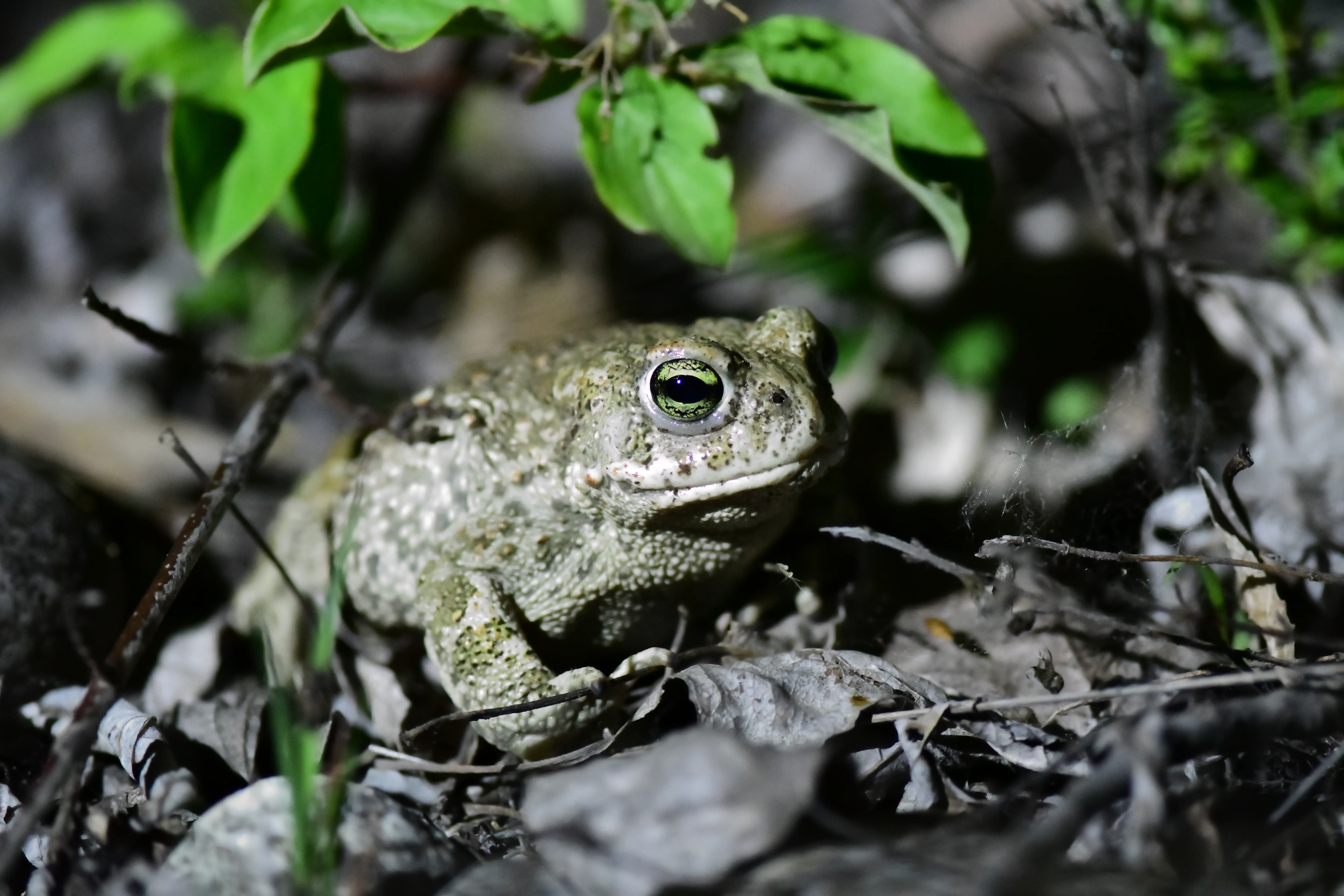
A warty, greenish-brown Natterjack toad sits on dry leaves and soil under low vegetation.
A Natterjack toad, a priority species for the reserve, rests on the forest floor at the Isles du Drac Regional Nature Reserve.

Réserve naturelle régionale des Isles du Drac history and protected-area timeline

The history of the reserve is closely tied to the transformation of the lower Drac valley by hydropower development. The Notre-Dame-de-Commiers dam, built in 1963, diverted most of the river's flow and reduced the channel to a minimal environmental discharge of about 1.5 cubic meters per second, far below what experts consider necessary to maintain natural river dynamics.

A decisive moment came on 4 December 1995, when a sudden water release from the dam during a school field trip at Saint-Georges-de-Commiers led to the drowning of seven people, including six children. The school group had come to observe beavers on the gravel banks of what would later become the reserve, highlighting both the appeal of the site and the dangers of unregulated flow management. As a result, access to the Drac's floodplain was strictly prohibited by prefectoral order from 1997 onward.

These pressures prompted local actors, within the framework of the SAGE Drac-Romanche, to seek a stronger protection status for the river corridor. On 8 July 2009, the regional natural reserve was officially created, and since 2019 it has been managed by Grenoble-Alpes Métropole. A new ten-year management plan covering 2025 to 2034 was adopted to coordinate conservation, monitoring, public outreach, and restoration actions across the reserve.

Réserve naturelle régionale des Isles du Drac landscape and geographic character

The reserve occupies the broad lower valley of the Drac, where the river leaves the narrower Alpine gorges and opens into an alluvial floodplain. The landscape alternates between active braided channels, vegetated islands, gravel bars, sandy banks, low alluvial terraces, and stretches of riparian woodland that follow the shifting course of the river.

This dynamic physical setting is set against a strongly humanized backdrop. Major departmental and national roads, motorways, railways, high-voltage lines, drinking-water catchments, hydroelectric installations, diversion canals, forced conduits, gravel pits, industrial platforms, chemical plants, and factories either cross through or border the reserve. The juxtaposition of active river processes with intensive infrastructure is a defining visual feature of the site.

Hydroelectric management by EDF imposes abrupt flow variations that periodically reshape gravel bars and terraces. Combined with a long-term trend of incision, paving of the riverbed, and narrowing of the active braided belt, these dynamics make the physical landscape both rich and fragile, and a central focus of the reserve's management priorities.
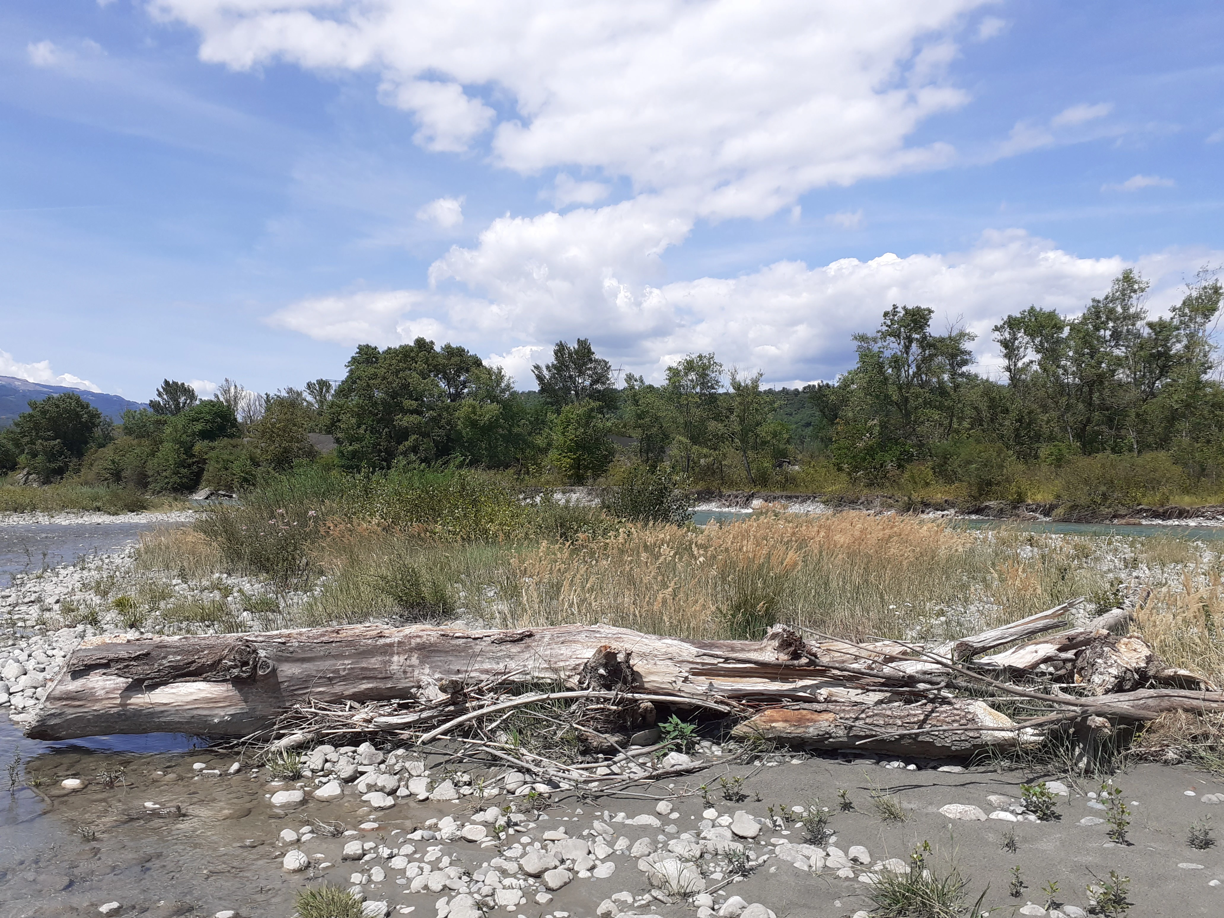
A wide view of a river bank with a large weathered log in the foreground, grasses, and a forest line under a partly cloudy sky.
Riparian habitat along the Drac River at the Isles du Drac Regional Nature Reserve.

Réserve naturelle régionale des Isles du Drac ecosystems, habitats, and plant life

Ecologically, the reserve is a textbook example of how a mosaic of habitats generated by a dynamic river can concentrate biodiversity within a small footprint. Gravel bars and pioneer gravel-bed communities, open sandy banks, herbaceous fringes, alluvial meadows, ponds, riparian forests, and wooded islands together produce a chain of complementary biotopes that change with the seasons and with the river's flow regime.

The alluvial plain supports the drinking-water aquifer that supplies Grenoble and its surrounding communities. Maintaining the river's ability to meander and rework its bed is therefore not only an ecological but also a hydrological priority, since the same dynamics that shape gravel bars also recharge groundwater.

Vegetation in the reserve comprises around 833 recorded plant species, of which several are protected at national or regional level. Eight species are considered high-priority for management, including the Montpellier thistle (Cirsium monspessulanum), the Swiss inula (Inula helvetica), the purple reedgrass-like false phragmites (Calamagrostis pseudophragmites), alpine rush (Juncus alpinoarticulatus), German tamarisk (Myricaria germanica), common adder's-tongue (Ophioglossum vulgatum), hairy crazyweed (Oxytropis pilosa), and celery-leaved buttercup (Ranunculus sceleratus). Together they reflect the transitional character of the site, where Alpine, montane, and Mediterranean influences meet.
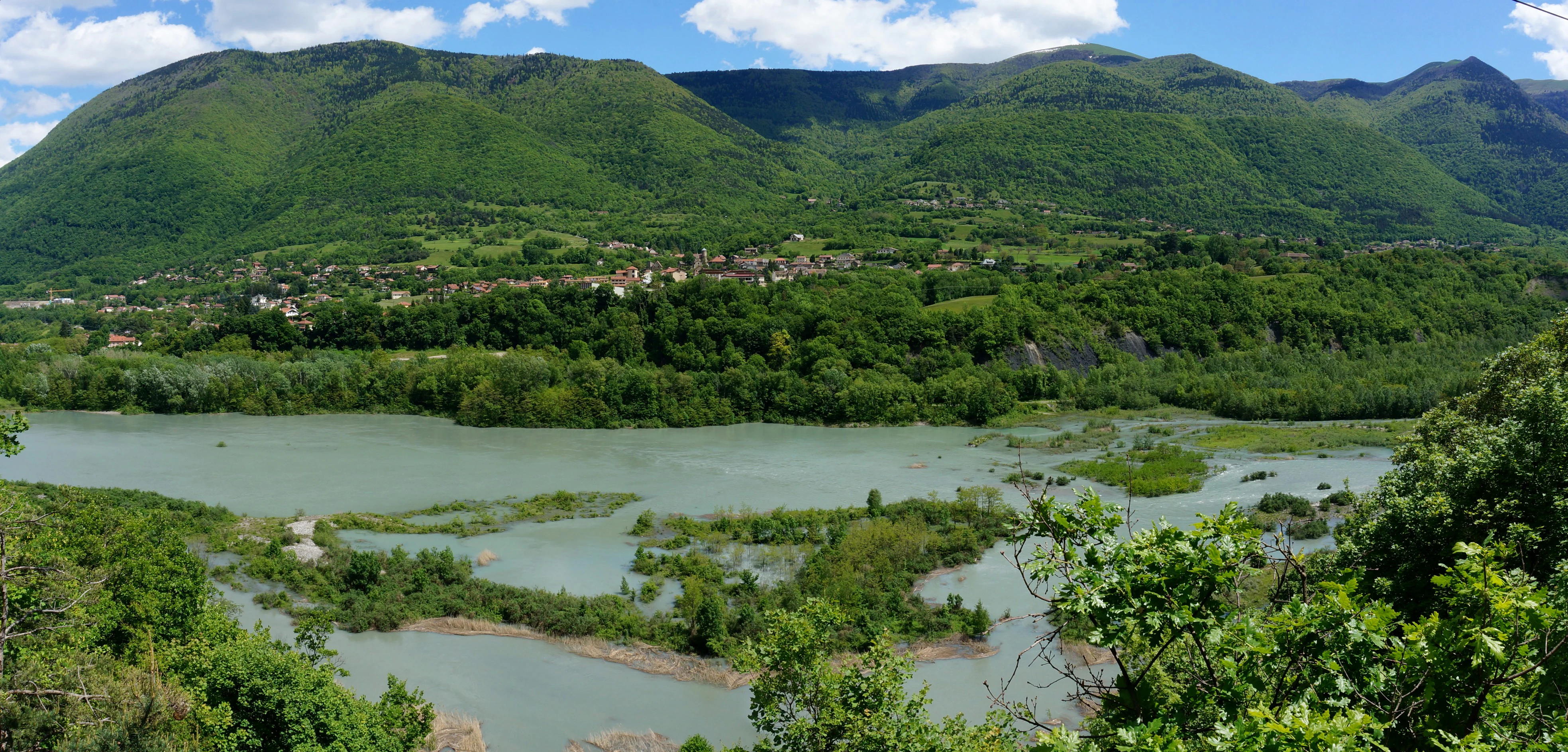
A wide view of the Drac River valley featuring a wide, silt-laden river with small islands and vegetation, set against a background of green, forested mountains under a blue sky.
The Drac River flowing through the valley near Saint-Georges-de-Commiers.

Réserve naturelle régionale des Isles du Drac wildlife and species highlights

The reserve records more than 1,437 animal species, a level of diversity that reflects the close juxtaposition of very different habitats in a small area. European beaver (Castor fiber) is among the most emblematic residents and was historically one of the species that attracted visitors to the gravel banks.

The site is important for both breeding and migratory birds. Species recorded include the European kingfisher, the European nightjar, Cetti's warbler, the little bittern, the black-crowned night heron, and the Eurasian woodcock, illustrating the reserve's role as a refuge along an Alpine bird corridor. Reptiles and amphibians include the southern smooth snake (Coronella girondina), the natterjack toad (Epidalea calamita, a priority 1 species for the reserve's management), and the midwife toad (Alytes obstetricans). Insects of conservation interest include the Mercury bluet (Coenagrion mercuriale), the sea-buckthorn hawkmoth, and the large blue butterfly (Phengaris arion).
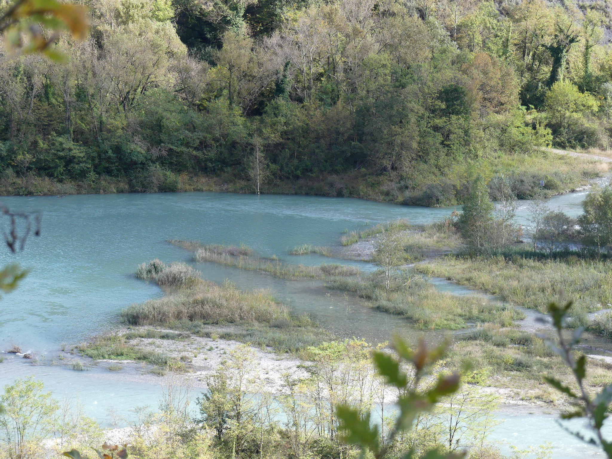
A wide view of a turquoise river winding through a wooded landscape, with low-lying islands, gravel banks, and riparian vegetation.
The Rivoire site within the Isles du Drac Regional Nature Reserve, showing riparian habitats along the Drac river.

Réserve naturelle régionale des Isles du Drac conservation status and protection priorities

The reserve is a key element of regional biodiversity policy in the Grenoble area, addressing the challenge of conserving a functioning braided-river ecosystem within a heavily engineered landscape. Its creation was a direct response to decades of hydromorphological degradation caused primarily by hydropower infrastructure and reduced environmental flows.

Conservation priorities include restoring the river's dynamic processes, limiting incision and loss of braided structure, and managing invasive alien species, which represent a growing threat to native plant communities. Water quality, climate change, and ongoing industrial activity in the surrounding plain are also identified as pressure factors influencing the river's capacity to host biodiversity.

The reserve's integration into the SAGE Drac-Romanche and its overlap with a ZNIEFF type I area give it a recognized role within French ecological planning frameworks. Management is structured around a ten-year plan, the latest covering 2025 to 2034, which coordinates monitoring, restoration, public engagement, and regulatory enforcement.

Réserve naturelle régionale des Isles du Drac cultural meaning and human context

The lower Drac valley has long been a corridor of human activity, where Alpine hydropower, transport infrastructure, and Grenoble's industrial growth have shaped both the landscape and the local communities. The reserve spans nine communes whose identities are tied to this combination of river, valley, and proximity to a major urban center.

The 1995 accident at Saint-Georges-de-Commiers left a lasting mark on the local relationship with the river, transforming once-casual access into a carefully managed experience. The reserve today reflects a broader cultural shift toward recognizing the ecological value of rivers even in heavily industrialized valleys, and toward treating urban-adjacent natural areas as part of regional identity rather than as remnants to be developed.

Top sights and standout views in Réserve naturelle régionale des Isles du Drac

The reserve's standout features are its braided Drac channels with shifting gravel bars, its riverside woodlands, and the exceptional concentration of protected plant and animal species persisting alongside major industrial and urban infrastructure. It is a textbook example of dynamic river conservation in a profoundly modified Alpine landscape.

Equally important is its accessibility for public engagement: the Chasse-Barbier site offers a discovery trail with interpretation facilities that introduce visitors to a riverside ecosystem they can see from the highway, making the reserve a benchmark for urban-adjacent environmental education in France.

Best time to visit Réserve naturelle régionale des Isles du Drac

Late spring and early summer are generally favorable for observing riverside vegetation and breeding birds, while the active braided channels and gravel bars are most visible during periods of low flow. Autumn can bring migratory species and changing colors in the riparian woodland, and winter floods occasionally reshape the gravel landscape, illustrating the dynamic character of the river.

Monthly climate preview

Long-term representative temperature ranges and precipitation normals across the year

Réserve naturelle régionale des Isles du Drac Climate and Monthly Weather Patterns

Representative coordinate records show average monthly temperatures swinging from sub-zero winter minimums to warm summer highs alongside steady precipitation rates. Reviewing the comprehensive twelve-month climatology profile provides deeper analytical depth into recorded thermal and moisture rhythms.
Annual mean8 °C
-1 °C17 °C
Jan-1°
Feb
Mar
Apr
May11°
Jun15°
Jul17°
Aug17°
Sep13°
Oct
Nov
Dec
Warmest month
August

16.9 °C

Coolest month
January

-0.8 °C

Wettest month
November

3.3 mm/day

Driest month
August

1.8 mm/day

Park location guide

Geography guide, regional context, and park location map for Réserve naturelle régionale des Isles du Drac

Réserve naturelle régionale des Isles du Drac park geography, regions, and map view in France

Understand where Réserve naturelle régionale des Isles du Drac sits in France through a broader geographic reading of the surrounding landscape, nearby location context, and its mapped position within the national park landscape.

How Réserve naturelle régionale des Isles du Drac fits into France

France is a unitary semi-presidential republic and one of the world's largest economies. It borders Belgium, Luxembourg, Germany, Switzerland, Italy, Monaco, Andorra, and Spain, with a maritime border to the United Kingdom. The country is known for its cultural influence, art, cuisine, and political history spanning centuries.

Wider geography shaping Réserve naturelle régionale des Isles du Drac in France

France is located in Western Europe. Metropolitan France extends from the Rhine to the Atlantic Ocean and from the Mediterranean Sea to the English Channel and North Sea. The country borders Belgium, Luxembourg, Germany, Switzerland, Italy, Monaco, Andorra, Spain, and has a maritime border with the United Kingdom.

Map view of Réserve naturelle régionale des Isles du Drac

Use this park location map to pinpoint Réserve naturelle régionale des Isles du Drac in France, understand its exact geographic position, and read its mapped placement within the surrounding landscape more clearly.

Pigeon | © OpenStreetMap contributors

Location context for Réserve naturelle régionale des Isles du Drac

Auvergne-Rhône-Alpes

Visual reference of braided river channels, gravel bars, and riparian habitats

Réserve naturelle régionale des Isles du Drac Photos, Landscapes, and Scenery

Visual records capture the shifting gravel bars, braided channels, and riparian woodlands of Réserve naturelle régionale des Isles du Drac. Photographic documentation reveals the intricate balance between dynamic riverine habitats and surrounding Alpine infrastructure.

A warty, greenish-brown Natterjack toad sits on dry leaves and soil under low vegetation.

A wooden interpretive sign mounted on a railing overlooking a calm, reflective pond in a nature reserve.

A wide view of a river bank with a large weathered log in the foreground, grasses, and a forest line under a partly cloudy sky.

A wide view of the Drac River valley featuring a wide, silt-laden river with small islands and vegetation, set against a background of green, forested mountains under a blue sky.

A wide view of a turquoise river winding through a wooded landscape, with low-lying islands, gravel banks, and riparian vegetation.

Park atlas

Compare nearby regional reserves and protected riverine landscapes across Auvergne-Rhône-Alpes

Parks Near Réserve naturelle régionale des Isles du Drac and Surrounding Alpine Protected Areas

Browse other protected areas and riverine ecosystems situated close to Réserve naturelle régionale des Isles du Drac. Evaluating adjacent Alpine valley geography helps place shifting braided river habitats and urban-adjacent reserves into a broader regional conservation context.
A pale, soft watercolor illustration showing a horizontal landscape of a pond and wetlands bordered by trees, with faint mountain silhouettes in the distance.
Nature reserveIsère
About 3.5 km away#1 closest

Northeast

Réserve naturelle régionale de l'étang de Haute-Jarrie, Isère Protected Wetland Landscape

Regional nature reserve and migratory bird sanctuary

Situated on the Plateau de Champagnier in Isère, this regional nature reserve offers a concentrated example of glacial pond ecology and wetland biodiversity. Covering 11 hectares, it acts as a critical stopover within the Grésivaudan valley migratory corridor. This protected site features diverse habitats, including reedbeds and wet meadows, that support hundreds of recorded bird species and a variety of dragonflies and amphibians, making it a significant area for ecological study.

Area
0.11 km²
Established
2008
IUCN
IV
Relief
Upland
Watercolor illustration showing mountains, a winding river, and pine trees in a landscape
National parkFrance
About 24 km away#2 closest

Southeast

Écrins National Park: Alpine Glaciated Terrain and Protected Landscape Details

Mapped boundaries and regional geography of a major French National Park.

Delve into Écrins National Park, a defining national park within the French Alps. This page provides a comprehensive overview of its protected landscape, focusing on its dramatic glaciated terrain, significant peaks such as the Barre des Écrins, and its position within the regional geographic context. Explore the mapped extent and understand the unique alpine environment of this protected area.

Area
925 km²
Established
1973
IUCN
II
Visitors
800K annual
A soft watercolor illustration featuring rolling green hills, a winding path, and distant mountain ridges in a muted, painterly style.
Nature reserveFrance
About 33 km away#3 closest

Southeast

Réserve naturelle nationale de la haute vallée du Béranger: Mountain Protected Area Map

Tracing the alpine terrain and torrent corridors in the French Alps.

Covering roughly 84 hectares in the Isère region, this nature reserve integrates traditional pastoral landscapes with steep-sided forest slopes and rocky alpine ridges. It functions as a key protective buffer for the larger Écrins National Park, preserving a representative slice of southern French Alpine geography within a single, cohesive valley setting.

Area
0.84 km²
Established
1974
Relief
Mountain
Climate
Alpine
A watercolor illustration of a landscape with purple and pink layered mountain peaks in the background and soft green trees in the foreground, set against a plain white background.
Nature reserveAuvergne-Rhône-Alpes
About 48 km away#4 closest

East

Réserve naturelle nationale de la haute vallée du Vénéon: Alpine Geography and Protected Boundaries

High-altitude mountain terrain in the French Alps

The Réserve naturelle nationale de la haute vallée du Vénéon occupies 61 hectares of striking alpine terrain near the hamlet of La Bérarde. Its landscape of steep slopes and glacial deposits functions as a key protected buffer zone, supporting diverse flora and fauna within the broader mountainous geography of the Auvergne-Rhône-Alpes region.

Area
0.61 km²
Established
1974
IUCN
IV
A watercolor illustration showing a soft, panoramic view of a calm lake surrounded by gentle, rolling green mountains.
Nature reserveAuvergne-Rhône-Alpes
About 49 km away#5 closest

North

Réserve naturelle régionale du lac d'Aiguebelette: Protected Lake and Forest Geography

Regional nature reserve landscape in the Savoie Prealps

This protected area encompasses the glacial basin of Lake Aiguebelette and the forested slopes of the Montagne de l'Épine. Discover a terrain defined by the contrast between deep mountain water and upland ridgelines, representing a critical habitat and species management zone within the Auvergne-Rhône-Alpes region.

Area
8.442 km²
Established
2015
IUCN
IV
Relief
Mountain
A watercolor painting of a river valley with soft green trees, rolling hills, and distant mountains under a light sky.
Nature reserveProvence-Alpes-Côte d'Azur
About 52 km away#6 closest

Southeast

Réserve naturelle nationale de la haute vallée de la Séveraisse: Protected Alpine Corridor

High-mountain riverine landscape and buffer zone in Hautes-Alpes

This nature reserve encompasses a 4-kilometer stretch of the upper Séveraisse valley, focusing on alluvial riverbed habitat and peripheral mountain terrain. Located in the French Alps, the reserve provides a protected transition zone characterized by its narrow, U-shaped valley floor and steep rocky inclines, offering a key geographic link to the wider Écrins ecosystem.

Area
1.55 km²
Established
1974
IUCN
IV
A soft watercolor painting depicting a wide river flowing through a lush green landscape with distant rolling purple hills in the background.
Nature reserveAuvergne-Rhône-Alpes
About 57 km away#7 closest

North

Rhône du Pont de Groslée à Murs-et-Gélignieux: Alluvial Nature Reserve & River Geography

Protected riparian habitat in Auvergne-Rhône-Alpes, France.

Analyze the complex fluvial dynamics of the Rhône du Pont de Groslée à Murs-et-Gélignieux nature reserve. This site features a well-preserved landscape of alder and ash floodplain forests, isolated side channels, and marshy meadows that provide an essential ecological corridor through the Rhône river valley.

Area
21.05 km²
Relief
Lowland
Scope
Terrestrial
Water
Water-dominated
A watercolor painting of a soft, rolling landscape with green hills, light forest cover, and wild grasses in the foreground, rendered in a light, atmospheric style.
Nature reserveAuvergne-Rhône-Alpes
About 63 km away#8 closest

Southwest

Réserve naturelle régionale de la grotte des Sadoux: Protected Cave and Forested Hills

Regional Nature Reserve in the Drôme department of France

The Réserve naturelle régionale de la grotte des Sadoux encompasses a 30-hectare forested coteau above the Courance valley. This site is defined by its subterranean karstic gallery and surrounding woodland edge, creating a focused conservation landscape for threatened bat species within the Auvergne-Rhône-Alpes region.

Area
0.3 km²
Established
2010
IUCN
IV
Relief
Upland

Common questions about visiting, size, designation, and location context for Réserve naturelle régionale des Isles du Drac

Réserve naturelle régionale des Isles du Drac FAQs for park facts, access, geography, and protected area context

Find quick answers about Réserve naturelle régionale des Isles du Drac, including protected-area facts, park geography, trail and visitor context, and how the park fits into its surrounding country and regional landscape.
MoriAtlas Explorer

Continue Your Protected Areas Search Across the Global Atlas

Deepen your exploration by continuing the structured search for national parks and protected areas worldwide. Utilize the comprehensive filtering capabilities to compare different conservation landscapes and refine your understanding of global park geography. Discover more about the distribution and characteristics of protected natural areas.

Global natural geography