
Mori Atlas logo
Nature reserveRéserve naturelle régionale du marais de la Vacherie

Examining the microtopography and ecological structure of wetland habitats within the Marais poitevin

Réserve naturelle régionale du marais de la Vacherie: Mapped Protected Coastal Wetland Landscapes

(Réserve naturelle régionale du marais de la Vacherie (RNR192))

Réserve naturelle régionale du marais de la Vacherie represents a significant fragment of traditional Atlantic marshland located in the southern Vendée department of Pays de la Loire. This protected area preserves an intricate network of wet meadows, drainage channels, and saline-influenced depressions that provide essential refuge for migratory waterbirds, amphibians, and the European otter. Through its distinctive microtopography, the reserve maintains a mosaic of plant communities that define the ecological character of this vital back-marsh zone along the Atlantic coast.

wetlandwet meadowsMarais poitevincoastal marshbirdwatchingwaterbirds
A flat, stylized illustration showing a mountain valley with a river, coniferous trees, and a distant waterfall under a bright sun and clouds.

Réserve naturelle régionale du marais de la Vacherie

Nature reserve

Park overview

Structured park overview, official facts, and landscape profile for Réserve naturelle régionale du marais de la Vacherie

Réserve naturelle régionale du marais de la Vacherie park facts, protected area profile, and essential visitor context

Review the core facts for Réserve naturelle régionale du marais de la Vacherie, including designation, size, terrain, visitor scale, habitats, and operating context in one park-focused overview.

About Réserve naturelle régionale du marais de la Vacherie

The Réserve naturelle régionale du marais de la Vacherie is a regional nature reserve nestled in the southern part of the Vendée department, within the commune of Champagné-les-Marais. Although it covers only a little over 180 hectares, it is ecologically significant because it lies inside the Marais poitevin, one of France's largest and most important wetland complexes, and because it preserves a particular type of coastal marsh that has become rare elsewhere in the region.

The reserve is geographically tied to the Atlantic coast. It sits around 10 km inland from the Baie de l'Aiguillon, a shallow estuarine bay that marks the seaward edge of the Marais poitevin. The closest town of any size is Luçon, a small historical town just a few kilometers to the east. Together with the surrounding marshlands, the reserve forms part of a wider ecological corridor that links inland wet meadows to the estuarine and coastal habitats of the Pertuis charentais.

Ecologically, the site stands out for its traditional wet meadows, known locally as prairies naturelles humides. These meadows have been shaped by centuries of low-intensity mowing and grazing, and they still show the characteristic microtopography of former coastal marshes: low-lying flooded depressions (baisses), intermediate slopes, and slightly higher dry ground (belles). This subtle relief controls water levels and residual salinity, and in turn produces a distinctive mosaic of plant communities and an associated rich fauna.

The reserve is managed by the Ligue pour la protection des oiseaux (LPO), the French bird protection society, reflecting the site's importance for birdlife. Public access is restricted to protect the habitats, but a visitor house known as the Maison de la réserve, at the lieu-dit Le grand Mothais, hosts an observation point, exhibitions, and guided events that explain the natural and cultural heritage of the marsh.

Quick facts and research context for Réserve naturelle régionale du marais de la Vacherie

The Réserve naturelle régionale du marais de la Vacherie covers roughly 181 hectares in the commune of Champagné-les-Marais, southern Vendée. It was classified as a regional nature reserve on 15 December 2008 by the Pays de la Loire region and is administered by the LPO. It belongs to the broader Marais poitevin wetland system and sits about 10 km north of the Baie de l'Aiguillon and 7 km from Luçon. Habitats are dominated by subhalophilic thermo-Atlantic wet meadows and eutrophic ditches and canals typical of natural marshes.

Protection and recognition

Review documented terrestrial protection scope, designation history, and administrative records.

Réserve naturelle régionale du marais de la Vacherie Protection Status and Designation Records

Terrestrial protection status for Réserve naturelle régionale du marais de la Vacherie is cataloged alongside designation history established in 2008. Official records track administrative classification details and verified conservation datasets without assuming management outcomes.

Protection details

Protection scope
Terrestrial
Designated year
2008
Transboundary protection
No
WDPA ID
555559619
Park context

Deeper park guide and search-rich context for Réserve naturelle régionale du marais de la Vacherie

Réserve naturelle régionale du marais de la Vacherie history, landscape, wildlife, and travel context

Explore Réserve naturelle régionale du marais de la Vacherie through its history, landscape character, ecosystems, wildlife, conservation priorities, cultural context, and seasonal travel timing in a structured park guide built for atlas discovery and search intent.

Why Réserve naturelle régionale du marais de la Vacherie stands out

The reserve is best known for its traditional wet meadows of the Marais poitevin, where microtopography creates a gradient from winter-flooded depressions to slightly higher ground with remnant saline influence. This mosaic supports an unusually rich flora for a relatively small area, including several protected plant species, and provides critical habitat for nesting, wintering, and migratory waterbirds along the Atlantic coast. Its conservation value is reinforced by the presence of mammals such as the European otter and a suite of amphibians, reptiles, and dragonflies typical of well-preserved back-marsh environments. The reserve is also notable as a long-term LPO acquisition project, built through successive land purchases since 1989.
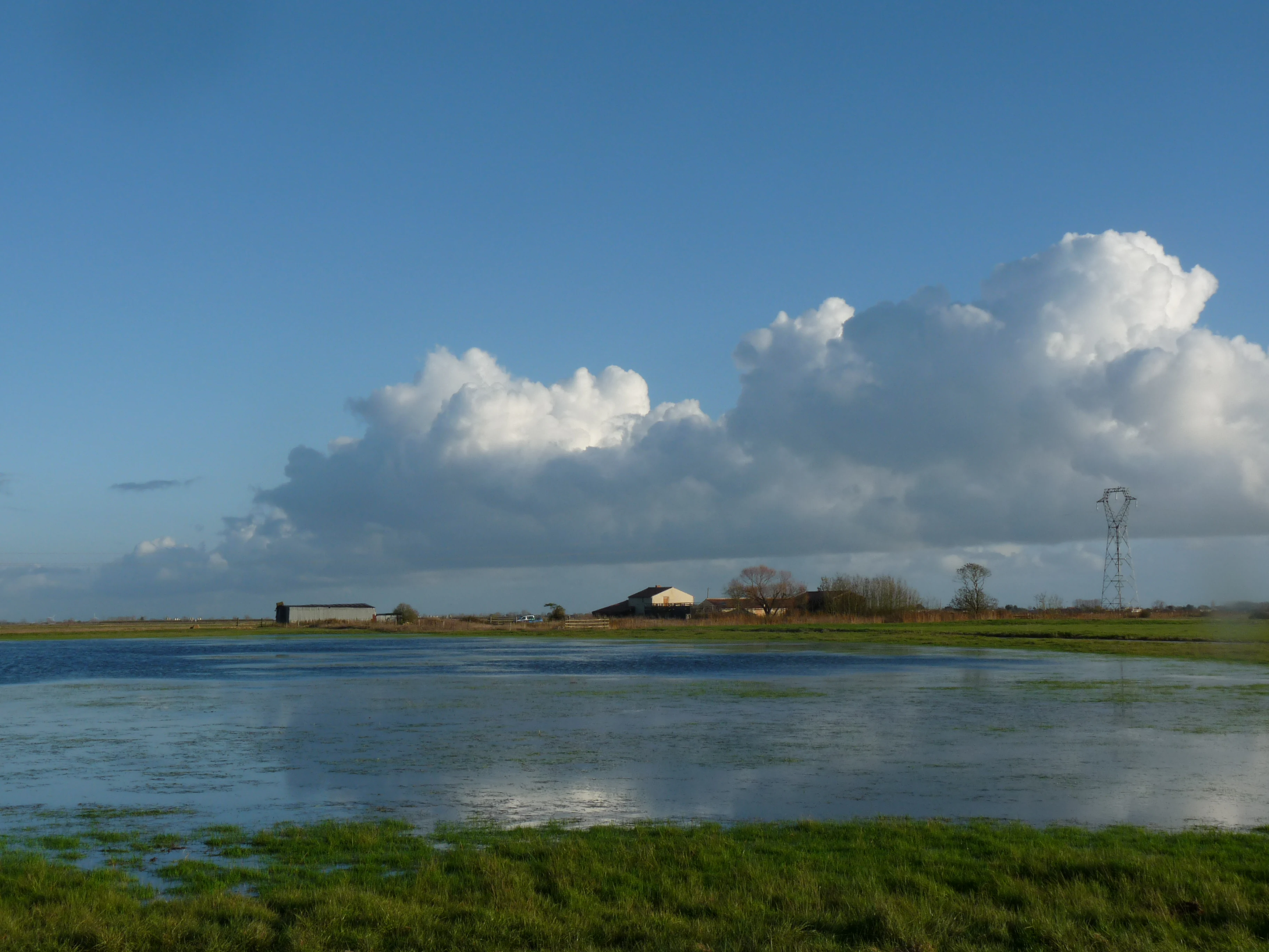
A wide, low-angle shot of a flat, grassy wetland area flooded with shallow water, reflecting the sky. In the middle distance, small structures are visible along the horizon line under a large, cloud-filled blue sky.
The reserve headquarters building situated by the flooded meadows of the Réserve naturelle régionale du marais de la Vacherie.

Réserve naturelle régionale du marais de la Vacherie history and protected-area timeline

The history of the reserve is closely tied to a long-term land acquisition campaign by the LPO. The first parcels in the commune of Champagné-les-Marais were acquired in 1989 through the donation campaign known as 'Sauvons les marais de l'ouest', which aimed to protect threatened western French marshes.

In 1991, the LPO signed an agreement with the Dutch organization Vogelbescherming Nederland to acquire additional land and begin the first restoration and management work on the site. A further partnership was established in 1996 with the Société d'aménagement foncier et d'établissement rural (SAFER), which facilitated the purchase of parcels within a wider 600-hectare perimeter, gradually consolidating a network of meadows that could be managed coherently.

In 2006, the LPO approached the Pays de la Loire regional council to request official classification as a régional nature reserve. After several years of preparation, the regional council formally classified the site on 15 December 2008, creating the Réserve naturelle régionale du marais de la Vacherie and entrusting its management to the LPO. The reserve is now embedded in the broader institutional framework of France's regional nature reserve network.

Réserve naturelle régionale du marais de la Vacherie landscape and geographic character

The landscape of the reserve is a classic example of Atlantic coastal marsh, defined by flat, low-lying terrain and an intricate mosaic of meadows, ditches, and small water channels. It sits within the back-marsh zone of the Marais poitevin, an area where the original marine gulf that once reached as far inland as Niort was gradually filled with marine sediments and fluvial alluvium, leaving behind gently undulating terrain barely above sea level.

The defining topographical feature is the microtopography of the meadows, organized around three repeating elements: low depressions or baisses that flood in winter, intermediate slopes that may retain a slight saline influence, and slightly raised areas or belles that stay drier. This pattern, almost imperceptible at ground level, is the result of centuries of sedimentation, drainage, and agricultural use, and it strongly conditions both plant communities and wildlife.

Surface water is channelled through a dense network of ditches, canals, and small channels that historically drained the marsh for grazing and hay-making. Today these linear features are part of the landscape's ecological structure, providing habitat for aquatic plants, amphibians, and invertebrates, and serving as movement corridors for otters and bats. The horizon is open, often flat, and broken mainly by lines of trees along property boundaries, low embankments, and distant silhouettes of the surrounding bocage.

Réserve naturelle régionale du marais de la Vacherie ecosystems, habitats, and plant life

Ecologically, the reserve is defined by two main natural habitat types. The first is subhalophilic thermo-Atlantic wet meadows, a habitat that reflects the transitional coastal location of the site, where residual salinity and a mild oceanic climate combine to produce specialized plant assemblages. The second consists of eutrophic rivers, canals, and ditches typical of natural marshes, which thread through the meadows and connect them to the larger Marais poitevin hydrological system.

Together, these habitats support an unusually high level of botanical diversity for an area of this size. The flora includes around 191 recorded species, of which 33 are considered remarkable and five are legally protected at the national or regional level. These protected plants, including species such as Ranunculus ophioglossifolius, Trifolium michelianum, Iris spuria, Ceratophyllum submersum, and Cardamine parviflora, are closely tied to the microtopography and to the gradients of flooding and salinity that define the marsh.

Beyond plants, the reserve functions as a sanctuary for fauna typical of well-preserved Atlantic marshes. Wet meadows, ditches, and adjacent reedbeds provide breeding, feeding, and sheltering habitat for numerous bird, mammal, amphibian, reptile, and insect species, and the site acts as an important refuge within the wider Marais poitevin, where many of these species have declined due to agricultural intensification and drainage.

Réserve naturelle régionale du marais de la Vacherie wildlife and species highlights

The reserve is particularly important for birds. In spring and summer, it hosts breeding populations of waders and waterbirds such as common redshank, black-tailed godwit, black-winged stilt, northern lapwing, and black tern, along with various duck species. In winter and during migration, the meadows and ditches serve as feeding and roosting sites for large numbers of waterbirds and shorebirds, including northern lapwing, European golden plover, and ruff.

Mammals are also well represented. The European otter regularly uses the ditches and channels of the reserve, while several bat species and small mammals characteristic of wetland environments, such as the water vole and the Eurasian water shrew, are also present. The combination of standing water, dense vegetation, and quiet marsh conditions makes the site especially suitable for species sensitive to human disturbance.

The reserve also supports a diverse community of amphibians and reptiles, including the marbled newt, the parsley frog, the green and yellow whip snake, and the viperine snake, as well as a rich dragonfly fauna that includes species such as Coenagrion scitulum and Orthetrum albistylum. Many of these groups depend on the mosaic of meadows, ditches, and shallow water typical of the site.

Réserve naturelle régionale du marais de la Vacherie conservation status and protection priorities

The reserve's conservation value lies in its role as a refuge for traditional Marais poitevin wet meadows, a habitat that has been progressively lost elsewhere in the region through drainage, conversion to cropland, and intensification. By maintaining extensive meadows with gentle water-level management, low stocking rates, and minimal chemical input, the reserve preserves both habitat structure and the species assemblages that depend on it.

Its ecological importance is enhanced by its position within the larger Marais poitevin, a wetland complex of roughly 100,000 hectares, and by its proximity to the Baie de l'Aiguillon. Together, these areas form a continuum of coastal and inland wetlands that supports migratory and resident species along the Atlantic flyway. The reserve also contributes to the protection of legally protected plant species and helps maintain viable populations of mammals such as the European otter.

Protection is enforced through regulated public access, with the interior of the reserve closed to visitors except during guided events. Collecting plants and hunting are strictly prohibited, ensuring that the site's wildlife is not disturbed and that the habitats remain in a near-natural state. Long-term management by the LPO combines ecological monitoring, grazing and mowing regimes adapted to the meadows, and public engagement through education programs.

Réserve naturelle régionale du marais de la Vacherie cultural meaning and human context

The reserve is embedded in a rural landscape with deep historical roots. The Marais poitevin was progressively shaped from a former marine gulf into productive farmland through centuries of drainage, ditch construction, and traditional hay-making. The meadows and the network of canals, ditches, and embankments reflect this long co-evolution between people and the marsh environment.

Traditional land uses, such as low-intensity mowing for hay and light grazing, continue to play a role in maintaining the habitats the reserve protects. The visitor centre at Le grand Mothais interprets both the natural heritage and the cultural heritage of the marsh, linking the landscape to the region's agricultural and rural history. In this way, the reserve is as much a cultural artifact of traditional marshland farming as it is a wildlife sanctuary.

Top sights and standout views in Réserve naturelle régionale du marais de la Vacherie

The reserve's strongest features are its traditional wet meadows with their characteristic microtopography, its wealth of legally protected and rare plants tied to flooding and salinity gradients, and its importance for breeding, wintering, and migratory waterbirds within the Marais poitevin. The presence of European otters, a diverse bat and amphibian community, and rich dragonfly fauna further strengthen its ecological profile.

Equally notable is the LPO's long-term approach to conservation, built through successive land purchases and partnerships since 1989 and culminating in formal classification as a regional nature reserve in 2008. Combined with restricted public access and guided events at the Maison de la réserve, this makes the site a compact but high-quality example of community-led wetland protection on the French Atlantic coast.

Best time to visit Réserve naturelle régionale du marais de la Vacherie

Spring is one of the most rewarding seasons, when wet meadows come into flower, many protected plants become visible, and breeding waders, terns, and ducks are active on the reserve. Early summer offers further opportunities to observe dragonflies, amphibians, and meadow vegetation at their peak, while still supporting active birdlife.

Autumn and winter bring a different character. The meadows partially flood, attracting large numbers of wintering and migratory waterbirds such as lapwings, golden plovers, and ruffs. Cooler months can therefore offer excellent birdwatching conditions, with outdoor observation from the accessible viewpoint at the Maison de la réserve. Visitors seeking a quieter, more contemplative experience may prefer these cooler seasons, when the marsh landscape takes on a stark, atmospheric quality.
Monthly climate preview

Long-term representative point measurements tracking annual temperature and precipitation rhythm

Réserve naturelle régionale du marais de la Vacherie Climate and Weather by Month

Representative coordinate records show average temperatures ranging from winter lows below freezing to summer highs near 31 degrees Celsius alongside recorded monthly precipitation rates. Detailed monthly normals provide deeper insight into annual meteorological patterns across the protected landscape.
Annual mean12 °C
6 °C20 °C
Jan
Feb
Mar
Apr11°
May14°
Jun18°
Jul20°
Aug20°
Sep17°
Oct13°
Nov
Dec
Warmest month
August

19.6 °C

Coolest month
January

5.9 °C

Wettest month
November

3.2 mm/day

Driest month
July

1.5 mm/day

Park location guide

Geography guide, regional context, and park location map for Réserve naturelle régionale du marais de la Vacherie

Réserve naturelle régionale du marais de la Vacherie park geography, regions, and map view in France

Understand where Réserve naturelle régionale du marais de la Vacherie sits in France through a broader geographic reading of the surrounding landscape, nearby location context, and its mapped position within the national park landscape.

How Réserve naturelle régionale du marais de la Vacherie fits into France

France is a unitary semi-presidential republic and one of the world's largest economies. It borders Belgium, Luxembourg, Germany, Switzerland, Italy, Monaco, Andorra, and Spain, with a maritime border to the United Kingdom. The country is known for its cultural influence, art, cuisine, and political history spanning centuries.

Wider geography shaping Réserve naturelle régionale du marais de la Vacherie in France

France is located in Western Europe. Metropolitan France extends from the Rhine to the Atlantic Ocean and from the Mediterranean Sea to the English Channel and North Sea. The country borders Belgium, Luxembourg, Germany, Switzerland, Italy, Monaco, Andorra, Spain, and has a maritime border with the United Kingdom.

Map view of Réserve naturelle régionale du marais de la Vacherie

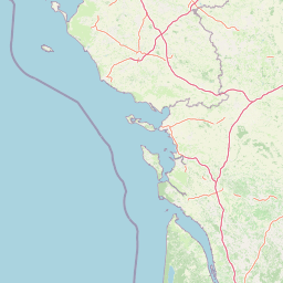
Use this park location map to pinpoint Réserve naturelle régionale du marais de la Vacherie in France, understand its exact geographic position, and read its mapped placement within the surrounding landscape more clearly.

Pigeon | © OpenStreetMap contributors

Location context for Réserve naturelle régionale du marais de la Vacherie

Pays de la Loire

Visualizing the coastal marsh habitats, wet meadows, and terrain of the protected area

Réserve naturelle régionale du marais de la Vacherie Photos and Landscape Scenery

Visual records capture the flat coastal terrain, intricate drainage ditches, and winter-flooded wet meadows defining the protected landscape. Photographic reference helps observers examine the microtopography and wetland habitats characteristic of the Atlantic reserve.

A wide, low-angle shot of a flat, grassy wetland area flooded with shallow water, reflecting the sky. In the middle distance, small structures are visible along the horizon line under a large, cloud-filled blue sky.

Park atlas

Compare adjacent coastal marshes and protected natural areas across the regional landscape.

Parks Near Réserve Naturelle Régionale Du Marais De La Vacherie and Surrounding Wetlands

Users viewing Réserve naturelle régionale du marais de la Vacherie can browse adjacent wetland reserves and coastal protected landscapes. Comparing nearby habitats reveals broader ecological patterns across the Atlantic seaboard.
Nature reservePays de la Loire
About 12 km away#1 closest

West

Réserve naturelle régionale de la ferme de Choisy: Marshland Protected Area and Regional Geography

Sub-brackish wet meadows of the Marais poitevin, Pays de la Loire.

Discover the unique ecological character of Réserve naturelle régionale de la ferme de Choisy, a vital wetland site in western France. This reserve showcases the intersection of traditional pastoral management and marshland conservation, hosting extensive bird populations and rare flora across its low-lying, reclaimed landscape.

Area
0.8 km²
Established
1991
IUCN
IV
Relief
Lowland
Nature reservePays de la Loire
About 14 km away#2 closest

East

Réserve naturelle régionale du marais communal du Poiré-sur-Velluire Regional Nature Reserve

Mapping wetland biodiversity in the Pays de la Loire region

Spanning over 240 hectares of reclaimed marshland, this protected area stands as a unique ecological stronghold in France. The reserve demonstrates how traditional collective land management sustains a rich mosaic of freshwater and brackish habitats, supporting more than 177 bird species and heritage livestock breeds in an expansive, open terrain.

Area
2.41 km²
Established
2012
IUCN
IV
Scope
Terrestrial
A horizontal watercolor painting depicting a winding river or lagoon flowing through rolling green hills and wetlands.
Nature reserveVendée
About 19 km away#3 closest

West

Réserve naturelle nationale de la casse de la Belle-Henriette: Geography and Protection

Coastal lagoon and dune habitat atlas in Vendée

Covering a narrow strip of the Atlantic coast, Réserve naturelle nationale de la casse de la Belle-Henriette protects essential marine lagoon and saltmarsh habitats. This data set explores the reserve's shifting dune morphology and its significance as a migratory bird corridor within the broader coastal geography of the Pays de la Loire region.

Area
3.37 km²
Established
2011
IUCN
IV
Relief
Lowland
Nature reserveNouvelle-Aquitaine
About 47 km away#4 closest

East

Réserve naturelle régionale du marais de Galuchet et des boucles de la Sèvre Niortaise Geography and Map

Urban protected wetland in the Nouvelle-Aquitaine region of France

This urban nature reserve protects 151 hectares of diverse wetland habitats along the Sèvre Niortaise. The landscape is defined by river meanders, wet meadows, and riparian corridors, making it a critical site for regional biodiversity and urban ecological connectivity in the Deux-Sèvres department.

Area
1.51 km²
Established
2025
IUCN
IV
Relief
Lowland
Nature reserveDeux-Sèvres
About 58 km away#5 closest

East

Réserve naturelle régionale du bocage des Antonins: Protected Landscape and Geographic Atlas

Detailed ecological mapping of the Gâtine armoricaine countryside

The Réserve naturelle régionale du bocage des Antonins occupies a distinct space in the Deux-Sèvres department. This protected area serves as a repository for the traditional bocage countryside, featuring a complex arrangement of pollarded trees, wet meadows, and the historic étang des Forges. The site offers a significant look at the structural history of rural western France through its preserved environmental matrix.

Area
0.226 km²
Established
2015
IUCN
IV
Relief
Lowland
Nature reserveNouvelle-Aquitaine
About 70 km away#6 closest

South

Réserve naturelle régionale de la Massonne: Geographic Atlas and Protected Area Map

Mapped ecosystems within the Nouvelle-Aquitaine marshlands

Réserve naturelle régionale de la Massonne serves as a significant ecological corridor in western France, defined by its abrupt transition from coastal Brouage marshes to acidic heath. This atlas entry provides essential data on the reserve boundaries, mapped terrain types, and the structural diversity of its protected wetlands and shrublands, highlighting its role as a sanctuary for diverse nocturnal fauna.

Area
2.023 km²
Established
1997
IUCN
IV
Relief
Lowland
Nature reservePays de la Loire
About 78 km away#7 closest

Northwest

Réserve naturelle régionale du bocage humide des Cailleries: Protected Landscape and Regional Map

Wet bocage and oak woodland in the Lake Grand-Lieu watershed

Covering roughly 18 hectares, this protected area features a fine-textured mosaic of woody hedgerows, wet meadows, and multiple small ponds. The site acts as a functional refuge for varied flora and fauna, illustrating the traditional Atlantic landscape character within western France through its structured management of meadows and pond systems.

Area
0.182 km²
Established
2012
IUCN
IV
Relief
Lowland
Nature reserveNouvelle-Aquitaine
About 79 km away#8 closest

Southeast

Vallée de l'Antenne: A Protected River Valley and Alluvial Landscape in Nouvelle-Aquitaine

Mapping riparian ecosystems and rare wetland habitats

Trace the course of the Antenne river as it meanders through a finely textured mosaic of ash and alder forests, poplar plantations, and floodplains. As a designated Natura 2000 site, this nature reserve acts as a critical refuge for biodiversity in western France, offering a textbook example of a low-energy river system that descends gently through the landscape of the Charente departments.

Area
12.08 km²
Established
1999
Relief
Lowland
Climate
Mediterranean

Common questions about visiting, size, designation, and location context for Réserve naturelle régionale du marais de la Vacherie

Réserve naturelle régionale du marais de la Vacherie FAQs for park facts, access, geography, and protected area context

Find quick answers about Réserve naturelle régionale du marais de la Vacherie, including protected-area facts, park geography, trail and visitor context, and how the park fits into its surrounding country and regional landscape.
MoriAtlas Explorer

Continue Your Protected Areas Search Across the Global Atlas

Deepen your exploration by continuing the structured search for national parks and protected areas worldwide. Utilize the comprehensive filtering capabilities to compare different conservation landscapes and refine your understanding of global park geography. Discover more about the distribution and characteristics of protected natural areas.

Global natural geography