Mori Atlas logo
Nature reserveRéserve naturelle régionale du Tertre des canaux

Discover the mapped geography of this wetland mosaic and elevated terrain in the Sologne countryside

Réserve naturelle régionale du Tertre des canaux: A Protected Landscape in Centre-Val de Loire

(Réserve naturelle régionale du Tertre des Canaux)

The Réserve naturelle régionale du Tertre des canaux represents a vital node in the conservation landscape of central France. Spanning approximately 35 hectares within the Loir-et-Cher department, this protected area features a distinct mosaic of habitats shaped by alternating water channels and elevated terrain. Its designation highlights a commitment to safeguarding ecologically significant pockets within the broader, long-inhabited rural matrix of the Sologne region.

regional nature reserveSologneCentre-Val de LoireLoir-et-Cherwetland mosaicwoodland and heath

Réserve naturelle régionale du Tertre des canaux

Nature reserve

Park overview

Structured park overview, official facts, and landscape profile for Réserve naturelle régionale du Tertre des Canaux

Réserve naturelle régionale du Tertre des Canaux park facts, protected area profile, and essential visitor context

Review the core facts for Réserve naturelle régionale du Tertre des Canaux, including designation, size, terrain, visitor scale, habitats, and operating context in one park-focused overview.

About Réserve naturelle régionale du Tertre des Canaux

The Réserve naturelle régionale du Tertre des Canaux occupies a modest but ecologically meaningful slice of the Sologne, a traditional rural landscape in central France shaped by forests, heath, ponds, and a dense network of small water channels. Situated within the commune of La Ferté-Imbault in Loir-et-Cher, the reserve's 35-hectare perimeter sits in a part of the region long defined by the interaction between human land use and natural hydrology. The site, like much of the surrounding Sologne, displays a finely textured patchwork of habitats where water movement, soil variability, and historic land management combine to produce distinctive ecological conditions.

Designated in January 2026, the reserve is one of the newest entries in the French regional nature reserve catalog. Its classification through a deliberation of the Conseil régional du Centre-Val de Loire places it within the formal French framework of régional nature reserves, which are typically created to protect habitats, species, and ecological processes of regional importance under a dedicated governance structure. The reserve's registered identifier, RNR349, situates it chronologically among recent additions to this growing national network.

In ecological terms, the reserve's value comes less from its modest size than from its capacity to anchor habitat continuity in a wider working landscape. The Sologne is renowned for its biodiversity, which has long thrived in the interface between cultivated land, woodland, wetland, and abandoned or low-intensity areas. By protecting a continuous parcel defined largely by the 'tertre' and 'canaux' features in its name, the reserve safeguards the physical setting that supports this biodiversity and helps ensure that fragmentation pressures do not erode the ecological functions of the surrounding countryside.

For visitors and researchers, the reserve represents a typical French regional reserve: a place more meaningful for ecological study and conservation continuity than for large-scale tourism, but nonetheless relevant to the broader identity of the Centre-Val de Loire as a region that blends cultural landscape and natural heritage. The reserve also reflects a contemporary French conservation approach, in which small regional reserves complement national parks and larger natural parks by providing tightly targeted protection where it is most needed.

Quick facts and research context for Réserve naturelle régionale du Tertre des Canaux

The Réserve naturelle régionale du Tertre des Canaux is a regional nature reserve in the Centre-Val de Loire region of France, situated in the Loir-et-Cher department on the commune of La Ferté-Imbault. It covers approximately 35.05 hectares and is registered as RNR349 within the French regional nature reserve network. The reserve falls under IUCN protected-area Category IV, indicating habitat and species management as its primary conservation objective. It was officially classified on 23 January 2026 by decision of the Conseil régional du Centre-Val de Loire.

Protection and recognition

Explore terrestrial protection scope, management framework, and recognized status details

Réserve naturelle régionale du Tertre des canaux Protection Status and Formal Designation Facts

Terrestrial protection status and designation records for Réserve naturelle régionale du Tertre des canaux provide a clear baseline for conservation geography. Structured protection metrics and administrative context offer verified insights into the boundaries governing this natural landscape.

Protection details

Protection scope
Terrestrial
Park context

Deeper park guide and search-rich context for Réserve naturelle régionale du Tertre des Canaux

Réserve naturelle régionale du Tertre des Canaux history, landscape, wildlife, and travel context

Explore Réserve naturelle régionale du Tertre des Canaux through its history, landscape character, ecosystems, wildlife, conservation priorities, cultural context, and seasonal travel timing in a structured park guide built for atlas discovery and search intent.

Why Réserve naturelle régionale du Tertre des Canaux stands out

The reserve is best known for its mosaic of habitats in the Sologne region, shaped by networks of channels, wet ground, and contrasting soil conditions. Its name, Tertre des Canaux, directly references the small elevated terrain and waterways that define the local landscape. The site represents a typical example of how small reserves in central France are used to protect ecologically distinctive pockets within a broader rural matrix.

Réserve naturelle régionale du Tertre des Canaux history and protected-area timeline

The reserve's formal history is recent and closely tied to the regional nature reserve framework of Centre-Val de Loire. Its existence as a legally protected site began on 23 January 2026, when the Conseil régional adopted the deliberation establishing the Réserve naturelle régionale du Tertre des Canaux and assigning it the reference RNR349.

Prior to its classification, the site formed part of the rural and natural mosaic of the Sologne landscape around La Ferté-Imbault, a setting shaped over centuries by agricultural use, forestry, and the management of water channels. The regional designation reflects the continuation of a French conservation tradition that increasingly relies on small, well-targeted reserves to maintain ecological coherence within heavily human-shaped regions.

Réserve naturelle régionale du Tertre des Canaux landscape and geographic character

The landscape of the Tertre des Canaux reserve reflects the broader character of the Sologne, a region known for its alternating woodland, heath, marshy ground, ponds, and small channels. The site's name itself points to this physical identity: 'tertre' describes a small rise or elevated ground, while 'canaux' references the canals and water channels that thread through the local terrain.

Within the reserve's roughly 35 hectares, the ground transitions between slightly higher, drier sections and lower, wetter areas influenced by flowing or standing water. This topographic variety produces the mosaic structure that defines much of the surrounding countryside, where micro-relief and hydrology govern the distribution of vegetation and habitat. The result is a landscape of subtle contrasts, where short walks reveal meaningful shifts between dry and damp environments.

Réserve naturelle régionale du Tertre des Canaux ecosystems, habitats, and plant life

Ecologically, the reserve sits within the wider Sologne habitat complex, one of the most ecologically distinctive regions of Centre-Val de Loire. Typical Sologne habitats include mixed woodland, heathland, ponds, marshy edges, and wetland margins along channels, often assembled in close proximity to one another. The reserve's position in this matrix means it shares many of the broader region's ecological characteristics while protecting a specific, continuous block of them.

The presence of named water channels and a 'tertre' within the protected perimeter suggests that the site likely maintains the gradient between elevated, drier ground and lower, wetter zones that is characteristic of the Sologne. Such gradients are ecologically valuable because they support diverse plant communities and provide refuge and forage for a wide range of fauna, from amphibians and aquatic invertebrates in wetter sections to woodland and edge species on drier rises.

Réserve naturelle régionale du Tertre des Canaux wildlife and species highlights

Because the Sologne is widely recognized for its mix of woodland, wetland, and open-country species, the reserve's mosaic of habitats offers the conditions that support characteristic fauna of central France. Wet channels and damp hollows typically favor amphibians, dragonflies, and aquatic invertebrates, while drier elevated sections and woodland edges support small mammals, typical forest and edge birds, and a range of insects associated with traditional rural landscapes. The reserve contributes to maintaining this biological richness within a continuous protected block.

Réserve naturelle régionale du Tertre des Canaux conservation status and protection priorities

As a regional nature reserve, the Tertre des Canaux is part of the formal French system of protected areas designed to conserve regionally significant habitats and species. Its IUCN Category IV status reflects an emphasis on active management to maintain particular habitats and the species that depend on them. By creating a continuous protected parcel within a broadly inhabited rural region, the reserve helps counter fragmentation and preserves ecological functions that depend on habitat continuity, particularly around the small water channels and topographic transitions that define the site.

Réserve naturelle régionale du Tertre des Canaux cultural meaning and human context

The reserve lies at the heart of Sologne, a region of central France whose identity is deeply tied to its ancient mixture of forest, heath, ponds, and noble or bourgeois estates, and to traditional uses such as hunting, forestry, and small-scale agriculture. The commune of La Ferté-Imbault belongs to this long-standing rural and cultural context, and the reserve emerges as a contemporary conservation layer placed over a landscape that has been shaped by generations of human activity.

Top sights and standout views in Réserve naturelle régionale du Tertre des Canaux

The reserve's strongest features are its position within the ecologically rich Sologne landscape, its compact but coherent protected area of around 35 hectares, and its role as one of the most recent additions to the French regional nature reserve network. The interplay between the elevated 'tertre' and the surrounding 'canaux' gives the site a clear physical identity, while its January 2026 designation marks it as a present-day example of small-scale, targeted conservation in central France.

Best time to visit Réserve naturelle régionale du Tertre des Canaux

The reserve's character reflects the typical seasonal rhythm of the Sologne. Spring brings renewed activity across the wetlands and edges, with amphibians and insects becoming more visible along the channels and damp margins. Summer displays the full mosaic of greens in surrounding woodland and heath, with the contrast between drier 'tertre' ground and wetter channels at its most apparent. Autumn deepens the colors of woodland sections, while winter reveals the structural shape of the landscape and the visible pathways of the water channels that define the site.
Monthly climate preview

Long-term monthly temperature and precipitation patterns recorded at a representative coordinate

Climate Normals and Annual Temperature Rhythm for Réserve naturelle régionale du Tertre des canaux

Historical climate data for Réserve naturelle régionale du Tertre des canaux reveals distinct annual temperature variations alongside consistent monthly precipitation measurements. Analyzing the full twelve-month profile provides deeper insight into long-term meteorological averages across the protected landscape.
Annual mean12 °C
3 °C21 °C
Jan
Feb
Mar
Apr11°
May15°
Jun18°
Jul21°
Aug21°
Sep17°
Oct12°
Nov
Dec
Warmest month
July

20.6 °C

Coolest month
January

3.4 °C

Wettest month
May

2.2 mm/day

Driest month
March

1.6 mm/day

Park location guide

Geography guide, regional context, and park location map for Réserve naturelle régionale du Tertre des Canaux

Réserve naturelle régionale du Tertre des Canaux park geography, regions, and map view in France

Understand where Réserve naturelle régionale du Tertre des Canaux sits in France through a broader geographic reading of the surrounding landscape, nearby location context, and its mapped position within the national park landscape.

How Réserve naturelle régionale du Tertre des Canaux fits into France

France is a unitary semi-presidential republic and one of the world's largest economies. It borders Belgium, Luxembourg, Germany, Switzerland, Italy, Monaco, Andorra, and Spain, with a maritime border to the United Kingdom. The country is known for its cultural influence, art, cuisine, and political history spanning centuries.

Wider geography shaping Réserve naturelle régionale du Tertre des Canaux in France

France is located in Western Europe. Metropolitan France extends from the Rhine to the Atlantic Ocean and from the Mediterranean Sea to the English Channel and North Sea. The country borders Belgium, Luxembourg, Germany, Switzerland, Italy, Monaco, Andorra, Spain, and has a maritime border with the United Kingdom.

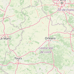
Map view of Réserve naturelle régionale du Tertre des Canaux

Use this park location map to pinpoint Réserve naturelle régionale du Tertre des Canaux in France, understand its exact geographic position, and read its mapped placement within the surrounding landscape more clearly.

Pigeon | © OpenStreetMap contributors

Location context for Réserve naturelle régionale du Tertre des Canaux

Centre-Val de Loire
Park atlas

Compare connected protected landscapes across the surrounding region

Other Parks Near Réserve naturelle régionale du Tertre des canaux

Visitors exploring Réserve naturelle régionale du Tertre des canaux can compare adjacent protected areas and regional nature reserves. Broadening the geographic scope reveals how small wetland habitats fit into the wider Sologne conservation network.
A soft watercolor painting of a rolling countryside landscape, featuring light green hills, patches of forest, and pale yellow foreground meadows.
Nature reserveCentre-Val de Loire
About 52 km away#1 closest

West

Réserve naturelle régionale géologique de Pontlevoy: Geological Protected Area and Map

A stratigraphic reference site in Centre-Val de Loire, France

Spanning less than two hectares, the Réserve naturelle régionale géologique de Pontlevoy functions as a highly concentrated outdoor laboratory for paleontology. The site protects a fossil-bearing quarry face that provides an essential cross-section of Cainozoic strata, including Beauce limestone and marine faluns dating back 14 to 16 million years.

Area
0.019 km²
Established
2011
IUCN
IV
Relief
Lowland
A horizontal watercolor painting depicting a wide river valley with grassy banks and distant hills in soft pastel shades of green, yellow, and muted pink.
Nature reserveBourgogne-Franche-Comté
About 78 km away#2 closest

East

Réserve naturelle nationale du val de Loire: Protected River Geography and Map

An active alluvial landscape in the French river corridor

The Réserve naturelle nationale du val de Loire preserves one of the most representative segments of a free-flowing river system in Europe. This protected corridor showcases an exceptionally active dynamic, featuring shifting sandbanks, calm backwaters, and diverse alluvial forests that define the valley floor. Learn about the geographic boundaries and the natural terrain that characterize this essential French nature reserve.

Area
14.54 km²
Established
1995
IUCN
IV
Relief
Lowland
Nature reserveCentre-Val de Loire
About 94 km away#3 closest

Southwest

Réserve naturelle régionale des terres et étangs de Brenne, Massé, Foucault Geographic Details

A managed wetland landscape in the Centre-Val de Loire

Analyze the terrain of the Réserve naturelle régionale des terres et étangs de Brenne, Massé, Foucault. This reserve showcases a dense network of freshwater ponds and diverse plant communities, including rare species like the marsh gentian, across a finely textured wetland environment in central France.

Area
3.19 km²
Established
2014
IUCN
IV
Relief
Lowland
A horizontal watercolor painting showing a green landscape with a winding stream, patches of marshy water, and distant hills, with soft light and green trees on the sides.
Nature reserveBourgogne-Franche-Comté
About 104 km away#4 closest

East

Réserve naturelle régionale des Mardelles de Prémery: Protected Wetland and Forest Geography

Mapping the peatland depressions of the Prémery forest

This nature reserve protects a rare assemblage of mardelles, shallow forest pools set within the Prémery state forest. The landscape serves as a vital ecological archive, with peat deposits documenting environmental changes over 15 millennia. Explore the unique hydrological and botanical features of this protected lowland habitat nestled in the heart of the Nièvre department.

Area
2.525 km²
Established
2015
IUCN
IV
Watercolor painting of a winding river flowing through a grassy plain, with soft green hills in the distance and a large rock in the foreground.
Nature reserveCentre-Val de Loire
About 107 km away#5 closest

Southwest

Réserve naturelle régionale du Bois des Roches: Geographic Overview and Protected Area Atlas

Limestone cliffs and archaeological landscapes in Centre-Val de Loire

Situated in the Indre department of France, this nature reserve is defined by its south-facing limestone cliffs and diverse ecological layers. Beyond its role as a sanctuary for bat colonies and thermophilic flora, the site reveals a deep history of Upper Paleolithic human occupation. MoriAtlas provides a comprehensive geographic look at this protected landscape and its structural role within the broader Brenne ecological context.

Area
0.122 km²
Established
1997
IUCN
IV
Relief
Upland
Nature reserveAuvergne-Rhône-Alpes
About 109 km away#6 closest

Southeast

Espace naturel sensible de la Vauvre Protected Wetland Reserve and Geographic Landscape

Mapping wetland conservation in the Allier department

Covering 46 hectares of reclaimed terrain, this protected nature reserve provides a critical sanctuary for birds and wetland species. The site functions as a documented mosaic of ponds and damp grasslands, offering a clear example of localized ecological restoration within the broader context of the Cher valley geography.

Area
0.46 km²
Established
1996
IUCN
IV
Relief
Lowland
A horizontal watercolor illustration depicting a soft, light-toned marshy landscape with green trees, reeds, and rolling hills in the background.
Nature reserveÎle-de-France
About 113 km away#7 closest

Northeast

Réserve naturelle régionale du marais de Larchant: Protected Landscape and Map Context

Wetland ecosystems at the edge of the Gâtinais plateau

Located in the Seine-et-Marne department, this regional nature reserve features a dynamic calcareous marsh ecosystem shaped by the Gâtinais plateau scarp. The site serves as a vital hydrological nexus, providing essential habitats for waterbirds and wetland flora through cyclic aquifer-fed flooding and diverse terrain patterns.

Area
1.24 km²
Established
2008
IUCN
IV
Relief
Lowland
Nature reservePays de la Loire
About 129 km away#8 closest

West

Réserve naturelle régionale des prairies et roselière des Dureaux: Loir Valley Protected Landscapes

Regional Nature Reserve in Pays de la Loire, France

Spanning the alluvial plains near Vaas, this reserve protects essential wet meadows and reedbed communities shaped by the seasonal rhythm of the Loir River. The landscape features a classic bocage character, offering a distinct example of wetland conservation within the Pays de la Loire region.

Area
0.253 km²
Established
2001
IUCN
IV
Relief
Lowland

Common questions about visiting, size, designation, and location context for Réserve naturelle régionale du Tertre des Canaux

Réserve naturelle régionale du Tertre des Canaux FAQs for park facts, access, geography, and protected area context

Find quick answers about Réserve naturelle régionale du Tertre des Canaux, including protected-area facts, park geography, trail and visitor context, and how the park fits into its surrounding country and regional landscape.
MoriAtlas Explorer

Continue Your Protected Areas Search Across the Global Atlas

Deepen your exploration by continuing the structured search for national parks and protected areas worldwide. Utilize the comprehensive filtering capabilities to compare different conservation landscapes and refine your understanding of global park geography. Discover more about the distribution and characteristics of protected natural areas.

Global natural geography