
Mori Atlas logo
Nature reserveRied am Föhrenbach

A vital sanctuary of reedbeds and wet meadows within the Rhineland-Palatinate landscape

Ried am Föhrenbach Nature Reserve: Mapped Protected Wetlands and Regional Landscape Context

(Naturschutzgebiet Ried am Föhrenbach)

Ried am Föhrenbach protects a significant wetland corridor along the Föhrenbach stream in the German state of Rhineland-Palatinate. The reserve serves as a critical refuge, housing the largest connected common reed stands in the Trier region and a surrounding mosaic of waterlogged grassland. This protected landscape preserves essential habitats for threatened bird and insect species amidst a heavily developed regional environment near the Moselle valley.

wetlandreedbednature reserveNaturschutzgebietRhineland-PalatinateMoselle region
A flat-style digital illustration showing a winding river flowing through a coniferous forest beneath tall, rocky mountains and a waterfall, with pine branches framing the top of the scene.

Ried am Föhrenbach

Nature reserve

Park overview

Structured park overview, official facts, and landscape profile for Ried am Föhrenbach

Ried am Föhrenbach park facts, protected area profile, and essential visitor context

Review the core facts for Ried am Föhrenbach, including designation, size, terrain, visitor scale, habitats, and operating context in one park-focused overview.

About Ried am Föhrenbach

Ried am Föhrenbach is a focused wetland nature reserve in the Moselle region of western Germany, lying just south of the village of Föhren and extending onto territory belonging to the town of Schweich. Its protected footprint of roughly 46.5 hectares may be modest at the national scale, but within its administrative region it carries outsized ecological importance.

The reserve's defining feature is its dense and unusually large reedbed complex. Reed (Schilf) is the structural backbone of many European wetland ecosystems, and the continuity of healthy stands here is what allows the broader wet-meadow community to function. Around the reedbeds lie damp and marshy grasslands that together create a coherent wetland landscape along the Föhrenbach, a small watercourse that gives the site its name.

The reserve sits in a transitional lowland position. To the west runs the L 47, to the northeast the L 48, and to the east both the L 141 and the busy A 1 autobahn. This setting means the protected area acts as a small but valuable ecological island within an intensively used transport and agricultural corridor.

Management of the reserve is anchored in the formal designation text, which sets out the goal of maintaining and developing the reedbeds and wet meadows as habitat for characteristic and threatened species. Birds and insects are singled out, reflecting the importance of the area for waterbird breeding, passage, and feeding as well as for the invertebrate communities that depend on healthy emergent vegetation.

Quick facts and research context for Ried am Föhrenbach

Ried am Föhrenbach is a designated Naturschutzgebiet (nature reserve) in Rhineland-Palatinate, Germany, located in Landkreis Trier-Saarburg between the municipality of Föhren and the town of Schweich. The reserve covers about 46.5 hectares of wetland habitat centered on the Föhrenbach stream. It was placed under protection on 25 September 1991 and is listed in the World Database on Protected Areas under WDPA ID 165172. The site is notable for hosting the largest continuous reedbed stands in the Regierungsbezirk Trier, together with adjacent wet and marshy meadows that support characteristic wetland fauna.

Protection and recognition

Comprehensive protection metrics and terrestrial management scope

Ried am Föhrenbach Protection Status and Official Designation Record

Terrestrial protection status and documented geographic management metrics define the conservation framework for Ried am Föhrenbach. Official recognition details and designation records establish the structural baseline for this protected area.

Protection details

Protection scope
Terrestrial
WDPA ID
165172
Park context

Deeper park guide and search-rich context for Ried am Föhrenbach

Ried am Föhrenbach history, landscape, wildlife, and travel context

Explore Ried am Föhrenbach through its history, landscape character, ecosystems, wildlife, conservation priorities, cultural context, and seasonal travel timing in a structured park guide built for atlas discovery and search intent.

Why Ried am Föhrenbach stands out

Ried am Föhrenbach is known above all for its extensive reedbeds: the reserve contains the largest contiguous Schilf (Phragmites) stands in the entire former Regierungsbezirk Trier. This core reed habitat is surrounded by wet meadows and moist grassland, forming a complete wetland mosaic along the Föhrenbach stream. The site's ordinance specifically names the preservation of bird and insect species threatened across the region as a central goal, making the reserve a key refuge for wetland-dependent fauna in an otherwise heavily developed agricultural and transport landscape.
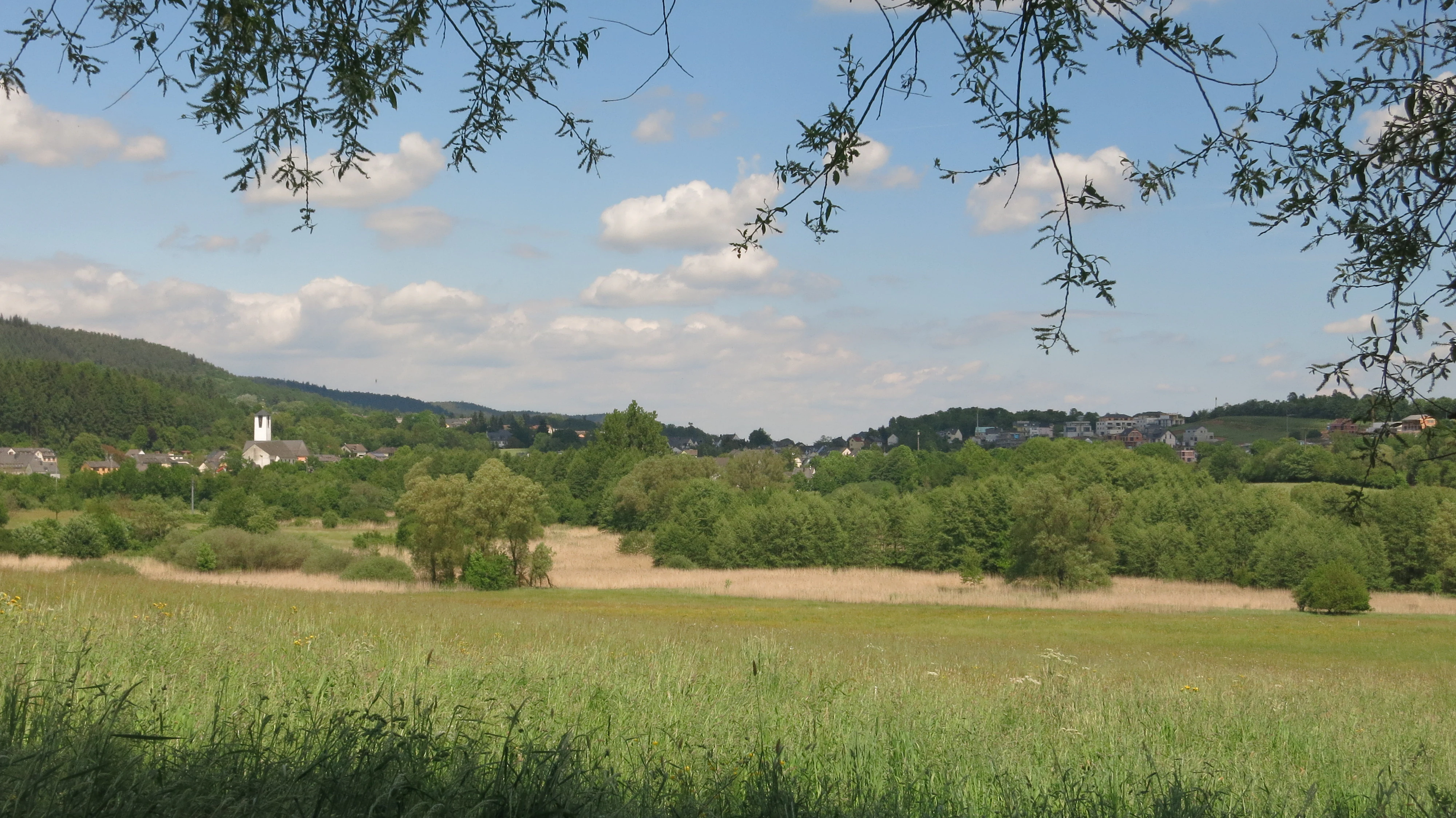
A green meadow leading to a patch of tan-colored reed beds and dense green trees, with a village and church visible in the distance under a blue sky.
A view of the reed beds and wetlands in the Ried am Föhrenbach nature reserve, framed by overhanging willow branches.

Ried am Föhrenbach history and protected-area timeline

Ried am Föhrenbach was formally placed under nature protection on 25 September 1991, when the responsible authorities issued a Naturschutzgebietsverordnung for the area. The designation was driven by recognition that the wetland along the Föhrenbach contained the largest connected reed stands in the Regierungsbezirk Trier and that these habitats, together with surrounding wet and marshy meadows, were essential refuges for threatened bird and insect species.

Since 1991, the reserve has continued to be managed under its original ordinance, focused on the preservation and development of its reed and wet-grassland habitats. It is registered internationally in the World Database on Protected Areas under WDPA ID 165172, securing its place within the broader European network of protected wetlands.

Ried am Föhrenbach landscape and geographic character

The landscape of Ried am Föhrenbach is dominated by flat, low-lying wetland terrain shaped by the small Föhrenbach stream. The valley floor is filled with tall, dense stands of common reed that form a continuous green wall through much of the reserve, particularly visible in late spring when the reeds are in full growth.

On the margins of the reedbeds, the terrain transitions into wet meadows and moist grasslands, creating a gentle gradient from open water influence to drier conditions. The reserve is narrow and elongated, following the course of the Föhrenbach south from Föhren into the Schweich municipal area, rather than spreading across a broad basin. Surrounding it is the patchwork of fields, roads, and settlements typical of the lower Moselle hill country, with the A 1 motorway defining much of the eastern horizon.

Ried am Föhrenbach ecosystems, habitats, and plant life

Ecologically, Ried am Föhrenbach is a classic lowland reed wetland, with the protected area organized around the Föhrenbach stream and its associated floodplain. The reedbeds form the structural and functional core of the site, providing cover, nesting substrate, and feeding areas for wetland fauna, while also filtering and moderating the hydrology of the small stream valley.

Around the reed fringe, communities of wet meadow and marsh grassland extend the habitat mosaic. These transitional zones support different plant assemblages and are critical for insects, amphibians, and many bird species that depend on the interface between open water vegetation and open ground. Together, the reedbeds and surrounding wet meadows act as a single integrated wetland system rather than a collection of isolated patches.

Ried am Föhrenbach wildlife and species highlights

The reserve's wildlife value is explicitly recognized in its designation ordinance, which highlights threatened birds and insects as priority groups. The reedbeds provide nesting habitat for reed-dependent bird species, while the wet and marshy meadows attract waders, waterfowl, and a wide range of passerines using the margins. Insects benefit from both the structural diversity of the reeds and the floral richness of the surrounding damp grasslands.

The continuity of reed stands over a relatively large area for the region gives Ried am Föhrenbach particular value as a stable breeding and feeding area for wetland fauna, supporting species that would struggle in smaller, more fragmented reed patches elsewhere in the Trier region.

Ried am Föhrenbach conservation status and protection priorities

Ried am Föhrenbach is conserved primarily to maintain and develop the largest connected reedbed complex in the Regierungsbezirk Trier, together with the associated wet and marshy meadows along the Föhrenbach. Its statutory purpose emphasizes habitat continuity and the protection of characteristic, threatened species, especially birds and insects.

Within Rhineland-Palatinate's network of small Naturschutzgebiete in Landkreis Trier-Saarburg, the reserve stands out for its wetland rather than woodland, slope, or river-valley character. Its registration in the World Database on Protected Areas further anchors it in international recognition of wetland sites, and its protected status shields it from the pressures of the surrounding road and motorway corridors as well as from intensive agricultural use of the adjacent land.

Top sights and standout views in Ried am Föhrenbach

The reserve's standout feature is its unusually large and continuous reedbed along the Föhrenbach, which serves as the structural backbone of the entire protected area. Surrounding damp meadows extend the habitat value outward, creating a coherent wetland landscape that supports threatened birds and insects. The 1991 designation and its inclusion in the World Database on Protected Areas underline the site's recognized importance at both regional and international levels.

Best time to visit Ried am Föhrenbach

Late spring and early summer are typically the most rewarding periods to experience Ried am Föhrenbach, when the reedbeds reach their full height and the wet meadow vegetation is most active. These seasons also coincide with peak bird breeding and insect activity in temperate European wetlands. Autumn can bring its own character as the reeds dry and seed, while winter visits may offer quieter wildlife observation. Site access conditions vary and should be checked locally, given the proximity of motorway and road infrastructure on the reserve's edges.

Monthly climate preview

Track long-term monthly averages and temperature ranges across representative terrain coordinates

Ried am Föhrenbach Climate Normals, Annual Temperature and Precipitation Patterns

Long-term representative records for Ried am Föhrenbach outline a measured annual progression of average monthly temperatures and daily precipitation rates. Examining the full twelve-month profile provides complete comparative data on historical temperature extremes and monthly precipitation normals.
Annual mean9 °C
0 °C18 °C
Jan
Feb
Mar
Apr
May12°
Jun16°
Jul18°
Aug18°
Sep14°
Oct
Nov
Dec
Warmest month
July

18.2 °C

Coolest month
January

-0.3 °C

Wettest month
December

2.5 mm/day

Driest month
April

1.6 mm/day

Park location guide

Geography guide, regional context, and park location map for Ried am Föhrenbach

Ried am Föhrenbach park geography, regions, and map view in Germany

Understand where Ried am Föhrenbach sits in Germany through a broader geographic reading of the surrounding landscape, nearby location context, and its mapped position within the national park landscape.

How Ried am Föhrenbach fits into Germany

Germany is a federal republic in Western and Central Europe with a population of over 83 million across sixteen constituent states. It is Europe's largest economy by nominal GDP and a major global exporter and importer. The capital is Berlin, and the country borders Denmark, Poland, Czech Republic, Austria, Switzerland, France, Luxembourg, Belgium, and the Netherlands.

Wider geography shaping Ried am Föhrenbach in Germany

Germany is located in Western and Central Europe, spanning 357,022 km². It borders Denmark to the north, Poland and the Czech Republic to the east, Austria and Switzerland to the south, and France, Luxembourg, Belgium, and the Netherlands to the west. The country has coastlines on the Baltic Sea and North Sea to the north, with the Alps located in the southern region.

Map view of Ried am Föhrenbach

Use this park location map to pinpoint Ried am Föhrenbach in Germany, understand its exact geographic position, and read its mapped placement within the surrounding landscape more clearly.

Pigeon | © OpenStreetMap contributors

Location context for Ried am Föhrenbach

Rheinland-Pfalz

Visualizing the protected reedbeds and valley habitats of Rhineland-Palatinate

Ried am Föhrenbach Photos, Landscapes, and Wetland Scenery

Visual records capture the extensive common reed stands and moist grassland mosaics that define the protected terrain of Ried am Föhrenbach. Examining these field photographs reveals the low-lying wetland character and stream-valley features preserved within the Moselle hill country.

A green meadow leading to a patch of tan-colored reed beds and dense green trees, with a village and church visible in the distance under a blue sky.

Park atlas

Compare adjacent protected landscapes and wetland reserves across the surrounding region

Exploring Parks Near Ried am Föhrenbach: Connected Wetlands and Regional Reserves

Browse other parks and protected areas situated within the wider valley geography surrounding Ried am Föhrenbach. Continuing the comparison reveals how lowland marsh habitats and river corridors connect across the regional terrain.
Watercolor painting of a rolling forested landscape with soft pink and yellow sky.
Protected areaGermany
About 2.3 km away#1 closest

Northwest

Meulenwald Protected Landscape: Topography and Geographic Context in the Eifel

A sandstone forest range and regional ecological landmark.

The Meulenwald offers a unique study in forest geography, spanning from the dense pine stands in the south to the varied shrubby clearings of the northern Heckenland. As a protected area near Trier, it showcases a remarkable botanical collection alongside a complex network of streams and ridges shaped by red sandstone, marking its status as a vital recreational and ecological anchor within Rhineland-Palatinate.

A minimalist watercolor painting featuring soft, abstract layers of green hills, purple distant ridges, and a pale yellow sky against a white background.
Nature reserveRheinland-Pfalz
About 14 km away#2 closest

Southwest

Gillenbachtal Nature Reserve: Geography and Protected Woodland Boundaries in Rheinland-Pfalz

A rare forest gorge and orchid habitat near the city of Trier.

Trace the boundaries and ecological features of Gillenbachtal, a designated nature reserve characterized by its steep-sided forest gorge and varied microclimates. This area serves as a critical protected enclave featuring deadwood habitats, limestone outcrops, and traditional orchard meadows that contrast with the urban development of nearby Trier.

Area
38.49 km²
Established
1995
Nature reserveRheinland-Pfalz
About 15 km away#3 closest

Northeast

Mesenberg bei Wittlich Nature Reserve: Protected Landscape and Habitat Map in Rhineland-Palatinate

Examining the sand-rich mosaics and woodland gradients of the Wittlicher Senke

Mesenberg bei Wittlich represents a structurally diverse nature reserve in Rhineland-Palatinate, Germany. The area contains a rare density of shifting sand pioneer communities, dry grasslands, and deadwood-rich deciduous forest. By maintaining these fine-grained ecological gradients, the protected land provides a critical window into the historical landscape characteristics of the Eifel foothills.

Area
1.52 km²
Established
2004
Relief
Lowland
Scope
Terrestrial
Watercolor painting of a rolling green forest landscape with a winding path and soft, abstract hills in the background.
Nature reserveRhineland-Palatinate
About 16 km away#4 closest

Southwest

Mattheiser Wald Nature Reserve: A Protected Forest Landscape in Rhineland-Palatinate

Ecological mapping of urban forest and valley terrain

Mattheiser Wald represents a vital nature reserve and Natura 2000 site in the Trier region. The area is characterized by high-value oak and hornbeam woodland, abandoned military disturbance zones that host rare wildlife, and an intricate stream valley system. This atlas entry provides a detailed look at the reserve's topography and its status as a critical conservation landscape within an urban environment.

Area
4.47 km²
Established
2003
Relief
Upland
Climate
Temperate
Nature reserveRhineland-Palatinate
About 24 km away#5 closest

Southwest

Wiltinger Saarbogen: Mapping the Natural Saar River Meander and Floodplain Habitats

A critical protected nature reserve in the Rhineland-Palatinate river landscape.

Wiltinger Saarbogen remains a rare, natural river arc within the Saar valley. This protected area offers a deep look into riverine geography, featuring a concentrated mosaic of gravel banks, reed-fringed wetlands, and riparian forests that stand in contrast to the engineered shipping canals of the region.

Area
1.67 km²
Established
1997
Watercolor painting of a green, rolling hillside landscape with faint pink floral details in the foreground.
Nature reserveRheinland-Pfalz
About 24 km away#6 closest

Southwest

Perfeist bei Wasserliesch: Protected Grassland and Botanical Mapping in Rheinland-Pfalz

A regional sanctuary for rare orchids and calcareous meadow flora.

Perfeist bei Wasserliesch represents a significant protected area within the German Moselle landscape. Spanning 22 hectares of dry, sun-exposed calcareous soil on the Liescher Berg, the reserve offers a focused look at open grassland ecology. Its unique status as a botanical reference point highlights how small-scale protected land maintains rare plant species and fragile meadow habitats against the backdrop of the surrounding Moselle valley hill country.

Area
0.22 km²
Established
1986
Watercolor painting of a forested landscape with rolling hills and distant mountains under a pale sky
National parkSaarland
About 24 km away#7 closest

Southeast

Hunsrück-Hochwald National Park: Saarland Protected Area Atlas and Landscape Context

Explore the mapped terrain and protected geography of this German national park.

Delve into the specific geography and protected landscape of Hunsrück-Hochwald National Park in Saarland. This detail page provides an atlas-centric view of the park's mapped boundaries, regional context, and its role as a national park. It serves as a foundational point for understanding the park's landscape features and its placement within the broader geographic atlas.

Area
100 km²
Established
2015
IUCN
II
Relief
Mountain
Watercolor painting of rolling green hills, small forest patches, and rocky outcrops under a soft, white background.
National parkRheinland-Pfalz
About 24 km away#8 closest

Southeast

Nationalpark Hunsrück-Hochwald: An Atlas and Geographic Overview of Protected Lands

Upland forest ecosystems and quartzite mountain terrain

The Hunsrück-Hochwald region showcases the transition of industrial-era forests toward near-natural wilderness. Its mapped territory integrates significant beech wood blocks with smaller wetland systems, reflecting a commitment to long-term biodiversity within the German uplands. Explore the structural composition and landscape features that define this protected zone.

Area
101.2 km²
Established
2015
IUCN
II
Relief
Mountain

Common questions about visiting, size, designation, and location context for Ried am Föhrenbach

Ried am Föhrenbach FAQs for park facts, access, geography, and protected area context

Find quick answers about Ried am Föhrenbach, including protected-area facts, park geography, trail and visitor context, and how the park fits into its surrounding country and regional landscape.
MoriAtlas Explorer

Continue Your Protected Areas Search Across the Global Atlas

Deepen your exploration by continuing the structured search for national parks and protected areas worldwide. Utilize the comprehensive filtering capabilities to compare different conservation landscapes and refine your understanding of global park geography. Discover more about the distribution and characteristics of protected natural areas.

Global natural geography