Why Rio Kapatchez Managed Nature Reserve stands out
The reserve is best known for its estuarine landscape, where the Kapatchez river, also called the Katako, opens into the Atlantic Ocean. The mixing of river and tidal waters produces brackish channels, mudflats, and mangrove-associated habitats typical of West African Atlantic coasts. It is also recognized internationally for its Ramsar status: inscription as wetland site 573 in 1992 places it among the formally designated wetlands of the Guinean coast, alongside the country's other tidal and estuarine systems. The combination of estuarine character, Ramsar recognition, and proximity to the Kapatchez river mouth defines the site's distinctive identity.
Rio Kapatchez Managed Nature Reserve history and protected-area timeline
The reserve was formally listed as a Wetland of International Importance under the Ramsar Convention on 18 November 1992, when it was registered as Ramsar site number 573. This international designation reflected existing recognition of the ecological value of the Kapatchez (Katako) estuary and the surrounding tidal habitats along Guinea's Atlantic coast.
Long before its protected status, the estuary was shaped by gradual sediment buildup. Local observations recorded in scientific literature point to significant silting (envasement) of the estuary from the 1930s onward, a process that has progressively altered the tidal channels, mudflats, and estuarine dynamics that the reserve now aims to safeguard.
Rio Kapatchez Managed Nature Reserve landscape and geographic character
The landscape of Rio Kapatchez is defined by the interface between river, estuary, and ocean. The Kapatchez river, known locally as the Katako, runs westward across the coastal lowlands of the Boké region before emptying into the Atlantic, creating a tidal estuary where freshwater flow mixes with marine influence. The surrounding terrain is characteristically flat and low-lying, shaped by long-term fluvial and tidal sediment deposition.
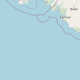
Between the estuary and the sea lie mudflats, saline channels, and mangrove-vegetated shorelines, while inland edges of the reserve blend into broader coastal wetlands of western Guinea. The reserve lies between Pointe Gonzalez at the mouth of the Rio Nunez and the Koumba river, anchoring a coastal segment that extends south toward Kamsar and northward toward Cap Verga. The cumulative effect of these features is a wetland-dominated coastal landscape with subtle elevation changes, where ecological character is set by water and sediment rather than by relief.
Rio Kapatchez Managed Nature Reserve ecosystems, habitats, and plant life
The reserve's ecological identity is estuarine and tidal rather than terrestrial. Its habitats fall within the broader category of West African Atlantic coastal wetlands, and the interplay of river discharge, tidal cycles, and Atlantic wave action drives the distribution of vegetation, sediment, and animal life across the site.
Mangrove-fringed shorelines, brackish channels, intertidal mudflats, and tidally influenced river margins together form the habitat mosaic typical of estuarine systems along the Guinean coast. These habitats are functionally connected to broader coastal processes, including sediment transport from inland rivers and nutrient exchange with the open Atlantic. The reserve's value lies in maintaining these estuarine dynamics within a formally protected framework.
Rio Kapatchez Managed Nature Reserve conservation status and protection priorities
Rio Kapatchez is internationally recognized through its inscription as Ramsar site 573 on 18 November 1992, placing it within the global network of Wetlands of International Importance. This designation reflects criteria related to the ecological role of the Kapatchez (Katako) estuary within Guinea's Atlantic coastal wetland system.
From a national perspective, the site is managed as a nature reserve (réserve naturelle gérée), giving it legal protection under Guinean conservation frameworks. The reserve's conservation significance is shaped both by its formal status and by dynamic environmental pressures, including the long-term silting of the estuary documented since the 1930s, which continues to influence habitat structure within the protected area.
Top sights and standout views in Rio Kapatchez Managed Nature Reserve
The reserve's defining features are its position at the mouth of the Kapatchez (Katako) river, its estuarine tidal habitat, and its formal protection as Ramsar site 573. Together these elements give the site a distinct identity within Guinea's coastal conservation landscape, where tidal wetlands meet the Atlantic Ocean in a setting shaped by both freshwater discharge and long-term sediment dynamics.