Mori Atlas logo
Wildlife reserveRoaring River Wilderness

Mapped boundaries and natural terrain within the Mount Hood region of Oregon

Roaring River Wilderness Protected Landscape and Cascade Range Geographic Atlas Context

Roaring River Wilderness serves as a significant protected block on the southwestern flanks of the Cascade Range in Oregon. This wilderness area preserves rugged ridges, ancient conifer forests reaching a thousand years in age, and a network of high-country lakes. The Roaring River serves as a vital corridor for native salmon populations, anchoring an essential segment of the Mount Hood National Forest ecosystem and offering a distinct look at Pacific Northwest wilderness geography.

Cascade RangeMount Hood National Forestold-growth forestwilderness areaalpine lakesalpine meadows

Roaring River Wilderness

Wildlife reserve

Park overview

Structured park overview, official facts, and landscape profile for Roaring River Wilderness

Roaring River Wilderness park facts, protected area profile, and essential visitor context

Review the core facts for Roaring River Wilderness, including designation, size, terrain, visitor scale, habitats, and operating context in one park-focused overview.

About Roaring River Wilderness

Roaring River Wilderness occupies a section of the western Cascade Range southwest of Mount Hood, Oregon's tallest peak. Although it sits in the shadow of the mountain, the wilderness has a character of its own, defined by deep forest, rushing water, and a transition from low-elevation conifer stands into higher, more open subalpine country. As part of the Mount Hood National Forest, it contributes to one of the most visited national forest landscapes in the Pacific Northwest and adds a quieter, less-developed counterpart to the more heavily used areas closer to the mountain.

The wilderness's namesake is the Roaring River, a tributary of the Clackamas River that cuts through the heart of the area. The river's energetic character gives the place both its name and much of its appeal: a wild, forested corridor where steep terrain, mossy stream banks, and salmon-bearing waters combine into a setting that feels distinctly Cascade in flavor. The river also connects the wilderness hydrologically to the broader Clackamas watershed, an important system for both ecological function and downstream water users.

Roaring River Wilderness is also notable for the age and quality of its forest cover. The area includes stands of old-growth trees that are estimated to be around a thousand years old, large enough and undisturbed enough to function as enduring forest ecosystems rather than simply as patches of mature timber. In the higher elevations, the forest gives way to meadows and lakes, producing a layered landscape where dense woodland, open basins, and rocky ridges all occur within a relatively compact area.

Because of its proximity to Portland and Mount Hood, and its adjacency to the larger Salmon-Huckleberry Wilderness, Roaring River also plays a regional role in protecting contiguous wild habitat in the central Cascades. Together, these protected blocks help maintain habitat connectivity for species that need large, undisturbed landscapes, while also offering a setting for low-impact recreation away from the more crowded areas of the Mount Hood region.

Quick facts and research context for Roaring River Wilderness

Roaring River Wilderness is a 36,500-acre wilderness area managed by the U.S. Forest Service within the Mount Hood National Forest. It lies in Clackamas County, Oregon, southwest of Mount Hood, and is centered on the Roaring River, a tributary of the Clackamas River. Designated in 2009, the area preserves a mix of old-growth forest, alpine lakes, meadows, and rugged Cascade terrain, and it sits near the larger Salmon-Huckleberry Wilderness.

Protection and recognition

Examine the documented conservation scope and international recognition records

Roaring River Wilderness Protection Status and Territorial Designation

Roaring River Wilderness maintains a defined terrestrial protection scope within its designated natural boundary. Protected area records compile official administrative details and international recognition data for comprehensive geographic analysis.

Protection details

Protection scope
Terrestrial
Transboundary protection
No
Park context

Deeper park guide and search-rich context for Roaring River Wilderness

Roaring River Wilderness history, landscape, wildlife, and travel context

Explore Roaring River Wilderness through its history, landscape character, ecosystems, wildlife, conservation priorities, cultural context, and seasonal travel timing in a structured park guide built for atlas discovery and search intent.

Why Roaring River Wilderness stands out

Roaring River Wilderness is best known for its old-growth conifer forests, a cluster of small alpine lakes such as Serene Lake and the Rock Lakes, and the Roaring River itself, which serves as habitat for native salmon. The area also features distinctive high-country terrain including Cache Meadow and Dry Ridge, giving it a classic Cascade landscape of forest, ridge, and meadow in a single protected block.

Roaring River Wilderness history and protected-area timeline

Roaring River Wilderness was established in March 2009, when President Barack Obama signed the Omnibus Public Land Management Act into law. Its creation was the result of several years of legislative effort focused on protecting the forested valley of the Roaring River and surrounding terrain in the southern reaches of the Mount Hood National Forest.

The process began in 2004, when Oregon Senator Ron Wyden introduced legislation that would have added the Roaring River area to the existing Salmon-Huckleberry Wilderness. That bill did not pass, but it established the idea of giving the valley formal wilderness protection. In the following year, U.S. House members from Oregon, including Earl Blumenauer and Greg Walden, proposed a separate bill to create a new wilderness area specifically for the Roaring River valley. The bill received unanimous support in committee and was also backed in principle by the Bush administration, which favored some expansion of wilderness around Mount Hood, though not at the scale proposed. Like the earlier Senate effort, the House bill did not become law.

In February 2007, Senators Wyden and Gordon Smith introduced yet another bill to designate the Roaring River Wilderness, this time as a stand-alone area. The effort ultimately succeeded when the broader Omnibus Public Land Management Act of 2009 included the designation. The Mount Hood region had long been a focal point for Oregon conservation politics, and the new wilderness reflected a willingness to expand federal protection in the Cascades even in watersheds that had previously been managed primarily for timber and other uses. The 2009 designation brought the area into the National Wilderness Preservation System and shifted its management toward a wilderness character defined by preservation, limited infrastructure, and non-mechanized recreation.

Roaring River Wilderness landscape and geographic character

The landscape of Roaring River Wilderness reflects a transition typical of the western Cascades, moving from densely forested low and middle elevations up into more open, rocky high country. Steep, tree-covered ridges frame the Roaring River and its tributaries, with the river cutting a vigorous corridor through the heart of the area. The terrain is dissected enough to create a sense of enclosure in the valleys, while the higher ridges and basins open up into broader views of forested slopes leading toward Mount Hood.

Among the most recognizable landscape features are the small lakes and meadows scattered through the higher elevations. Serene Lake, Shining Lake, Shellrock Lake, and the Rock Lakes cluster within the wilderness, each occupying glacially influenced basins characteristic of the central Cascades. Open areas such as Cache Meadow and the Dry Ridge and Grouse Point viewpoints add variety to a landscape that, from valley level, can appear almost unbroken in its tree cover. The result is a place where forest, water, and meadow alternate across relatively short distances.

Because the wilderness sits southwest of Mount Hood rather than directly on the mountain's slopes, it lacks the high alpine zone of the higher Cascades but retains much of the rugged mid-elevation character that defines the range. Drainages lead ultimately to the Clackamas River, and the Roaring River itself contributes both scenic energy and ecological function to the landscape. Together, these features create a setting that feels simultaneously remote and connected to the broader Cascade geography of the Mount Hood region.

Roaring River Wilderness ecosystems, habitats, and plant life

Roaring River Wilderness preserves a representative slice of the western Cascade ecological zone, where wet, temperate rainforest conditions support dense conifer growth, and where elevation creates a vertical layering of habitat types. The lower and middle slopes are dominated by mature and old-growth coniferous forest, with stands estimated to be roughly a thousand years old providing rare examples of long-undisturbed Cascade woodland. These forests are notable for their size, complexity, and the structural diversity that develops over many centuries without large-scale disturbance.

Above the dense forest belt, the wilderness includes subalpine and high-elevation habitats in more compact form. Small lakes, wet meadows, and rocky ridges support plant communities adapted to shorter growing seasons and harsher exposure. Cache Meadow, in particular, exemplifies the kind of open, moist meadow habitat that is relatively limited in the Cascades and therefore ecologically valuable, especially for species that depend on the edge between forest and meadow.

The Roaring River corridor itself is a defining ecological feature. As a tributary of the Clackamas River, it connects the wilderness to a larger watershed of regional ecological importance, and its cold, fast-flowing character, along with its forested banks, makes it well suited to supporting sensitive aquatic life.

Roaring River Wilderness wildlife and species highlights

The combination of old-growth forest, riparian habitat along the Roaring River, and meadow-edge openings in the higher country gives Roaring River Wilderness a varied wildlife community typical of the central Cascades. Spotted owls, which depend on large tracts of older forest, have been documented in the area. Pileated woodpeckers, another species closely tied to mature and old-growth conifer stands, also find suitable habitat here, and their presence is often taken as an indicator of overall forest health.

Larger mammals associated with the Cascades are part of the wilderness's fauna as well. Black bears, cougars, elk, and mule deer all occur in the general Mount Hood region and use the kinds of forest and meadow habitats found in Roaring River. These species benefit from the relatively undisturbed conditions and from the proximity of the wilderness to the larger Salmon-Huckleberry Wilderness, which together create a substantial block of low-impact habitat.

The Roaring River and its tributaries are ecologically meaningful for aquatic life. The river functions as spawning habitat for several species of salmon, linking the wilderness to the broader story of Pacific Northwest salmon recovery. Smaller and less conspicuous species, including salamanders, are also part of the fauna, and contribute to the rich understory of life supported by the area's wet forest environment. Common Cascade plant associates of the wildlife habitat include huckleberry, salal, and sword fern, which provide both food and cover across the forest and meadow transitions.

Roaring River Wilderness conservation status and protection priorities

Roaring River Wilderness is significant from a conservation standpoint primarily because it adds formal wilderness protection to a portion of the Mount Hood National Forest that had previously been managed with greater emphasis on resource extraction and recreation infrastructure. Its designation in 2009 brought roughly 36,500 acres into the National Wilderness Preservation System, locking in a management approach centered on preserving the area's wilderness character rather than developing it further.

The wilderness's old-growth forest stands are among its most important conservation features. Trees estimated to be around a thousand years old represent a level of biological continuity that cannot be recreated on any practical human timescale, and protecting them from logging and large-scale disturbance is a central purpose of the designation. The wilderness also safeguards the Roaring River's function as salmon spawning habitat, contributing to conservation of native fish populations that have declined across much of their historic range in the Pacific Northwest.

By linking ecologically with the adjacent Salmon-Huckleberry Wilderness, Roaring River Wilderness strengthens a larger landscape-scale network of protected habitat in the central Oregon Cascades. Habitat connectivity of this kind is increasingly recognized as essential for species that require extensive, low-disturbance ranges, and the 2009 designation reflects a deliberate effort to expand such connectivity in one of Oregon's most ecologically important mountain regions.

Roaring River Wilderness cultural meaning and human context

The Roaring River area lies within the broader cultural landscape of the Cascade Range in Oregon, a region long used and inhabited by Indigenous peoples whose presence shaped the land long before the establishment of national forests or wilderness designations. The river valleys and meadow basins of the central Cascades were part of traditional travel, hunting, and gathering territories, and plant species such as huckleberry and salal, which remain part of the wilderness's flora, were traditional resources.

In the more recent era, the area's cultural context is closely tied to the history of the Mount Hood National Forest itself, and to the Oregon conservation movement that has sought to balance timber production, recreation, and ecological protection. The legislative debates that produced Roaring River Wilderness, involving figures such as Senators Ron Wyden and Gordon Smith and Representatives Earl Blumenauer and Greg Walden, reflect the political and cultural effort to define what kind of landscape Mount Hood's forests should be in the twenty-first century.

Top sights and standout views in Roaring River Wilderness

Roaring River Wilderness combines three defining features within a relatively compact area: ancient old-growth conifer forest, a wild river corridor important for native salmon, and a cluster of high-country lakes and meadows that open up the otherwise dense forest canopy. Its proximity to Mount Hood and to the Salmon-Huckleberry Wilderness gives it added regional significance, anchoring a broader block of protected Cascade habitat. The combination of legislative history, ecological value, and closeness to one of Oregon's most recognizable natural landmarks makes it a meaningful example of late-2000s wilderness expansion in the Pacific Northwest.

Best time to visit Roaring River Wilderness

The character of a visit to Roaring River Wilderness shifts noticeably with the seasons. Summer is the most accessible window, when snow has melted from the lower and middle elevations and the network of trails, including those leading to Serene Lake and the Rock Lakes, can be reached on foot. Late summer and early fall are particularly appealing for combining lake basin visits with huckleberry-rich forest.

Spring and early summer bring high water in the Roaring River, swelling the stream that gives the wilderness its name and reinforcing its energetic character. Wet conditions and lingering snow can limit access in the higher basins, but the forest is at its most lush and the roar of the river is most pronounced. Late fall and winter bring snow to much of the area, restricting non-mechanized backcountry travel and turning the wilderness into a quiet, snow-covered landscape best suited to experienced winter users.

Monthly climate preview

Long-term temperature and precipitation records across the protected landscape

Roaring River Wilderness Climate Normals and Monthly Weather Patterns

Representative coordinate measurements trace the measured annual temperature and precipitation rhythm across Roaring River Wilderness. Detailed monthly climate normals provide broader context for studying long-term weather variations throughout the protected area.
Annual mean7 °C
-1 °C16 °C
Jan
Feb
Mar
Apr
May
Jun12°
Jul16°
Aug16°
Sep13°
Oct
Nov
Dec-1°
Warmest month
August

15.7 °C

Coolest month
December

-0.5 °C

Wettest month
December

7.3 mm/day

Driest month
July

0.5 mm/day

Park location guide

Geography guide, regional context, and park location map for Roaring River Wilderness

Roaring River Wilderness park geography, regions, and map view in United States of America

Understand where Roaring River Wilderness sits in United States of America through a broader geographic reading of the surrounding landscape, nearby location context, and its mapped position within the national park landscape.

How Roaring River Wilderness fits into United States of America

The United States of America is a federal presidential republic and one of the world's largest countries by area and population. It consists of 50 states across a vast territory spanning multiple time zones, with its capital in Washington, D.C. and largest city in New York City. The nation has a diverse economy, influential political system, and significant cultural and military presence globally.

Wider geography shaping Roaring River Wilderness in United States of America

The United States occupies a vast territory in North America, bordered by Canada to the north and Mexico to the south. The 48 contiguous states stretch from the Atlantic to the Pacific Ocean, while Alaska occupies the northwestern region and Hawaii is an archipelago in the Pacific. The country encompasses diverse terrain including the Rocky Mountains, Appalachian Mountains, Great Plains, and extensive river systems.

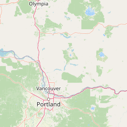
Map view of Roaring River Wilderness

Use this park location map to pinpoint Roaring River Wilderness in United States of America, understand its exact geographic position, and read its mapped placement within the surrounding landscape more clearly.

Pigeon | © OpenStreetMap contributors

Location context for Roaring River Wilderness

Oregon
Park atlas

Compare adjacent protected areas and regional wilderness zones in the Mount Hood region

Explore Parks Near Roaring River Wilderness and Surrounding Cascade Landscapes

Continue browsing parks near Roaring River Wilderness to examine connected forest reserves and protected river basins across the surrounding region. Comparing adjacent mountain terrain provides deeper geographic context for the broader Cascade Range ecosystem.
A watercolor painting showing a snowy mountain peak in the background rising above rolling green hills and pine forests in the foreground.
Protected landscapeOregon
Mapped location lies within the park boundary#1 closest

Northeast

Mount Hood National Forest: Atlas of Protected Landscapes and Volcanic Geography

Exploring the Cascade Range terrain and wilderness boundaries in Oregon.

Mount Hood National Forest encompasses a vast, rugged expanse of the Oregon Cascades, anchored by the iconic, glacier-clad Mount Hood. This protected landscape contains extensive old-growth forests, high-alpine lakes, and deep river canyons. Discover the geographic extent of these wilderness areas and mountain terrain within the MoriAtlas database of protected lands.

Area
4,318.17 km²
Established
1908
Visitors
4.4M annual
Relief
Mountain
A watercolor painting showing a wide, panoramic view of a mountain range in the background, rolling green hills in the midground, and a small cluster of evergreen trees in the foreground against a white background.
Wildlife reserveOregon
About 13 km away#2 closest

Northeast

Mount Hood Wilderness: Atlas of Volcanic Peaks and Glacial Geography in Oregon

High-altitude protected landscapes and forest ecosystems

This protected area captures the dramatic character of the Cascade Range through its signature volcanic terrain, ancient forests, and high-alpine ridges. Covering a vast vertical range, the wilderness offers a study in geologic forces, featuring active glaciers, deep basaltic canyons, and meadows that define the mountain's northern and western slopes.

Area
262 km²
Established
1964
IUCN
Ib
Visitors
10K annual
Protected landscapeOregon
About 16 km away#3 closest

East

Mount Hood National Recreation Area: Oregon Protected Landscape and Regional Geography

A three-unit recreational forest landscape in the Cascade Range.

Spanning over 34,000 acres, this protected landscape frames the lower volcanic slopes and forested drainages around Mount Hood. The area integrates river corridors, wilderness boundaries, and subalpine terrain, offering a clear view of the complex topography that defines the Cascade Range in northern Oregon.

Area
139.8 km²
Established
2009
Relief
Mountain
Climate
Temperate
Wildlife reserveOregon
About 35 km away#4 closest

North

Mark O. Hatfield Wilderness: An Atlas of Basalt Canyons and Cascade Mountain Terrain

Protected rugged wilderness located in Oregon

Spanning from the Columbia River Gorge to the slopes of Mount Hood, the Mark O. Hatfield Wilderness preserves an array of forest stands, hanging meadows, and steep ridgelines. The area serves as a critical geographic hub within the Cascade Range, offering detailed insight into the volcanic geology and drainage systems that shape this iconic portion of Oregon.

Area
266.37 km²
Established
1984
IUCN
Ib
Relief
Mountain
Protected landscapeOregon
About 40 km away#5 closest

South

Willamette National Forest: Geography and Protected Landscapes of the Central Oregon Cascades

Mapped terrain, old-growth forests, and protected wilderness boundaries.

Explore the expansive territory of Willamette National Forest, a primary protected area extending over 100 miles along Oregon's Cascade Range. This region features volcanic peaks exceeding 10,000 feet, extensive old-growth Douglas-fir stands, and a dense network of Wild and Scenic rivers, providing a detailed look at the geographic character and ecological heritage of the Pacific Northwest.

Area
6,790.75 km²
Established
1933
Visitors
1.7M annual
Relief
Mountain
A horizontal watercolor illustration featuring a waterfall on the left, a range of rolling mountains in the background, and clusters of trees in the midground, rendered in soft, blended colors.
Protected landscapeWashington
About 47 km away#6 closest

North

Gifford Pinchot National Forest: Geographic Overview of Washington's Volcanic Cascade Protected Lands

Mapping volcanic peaks, deep river canyons, and old-growth wilderness corridors

Gifford Pinchot National Forest represents a major protected expanse in the Washington Cascades, characterized by a complex volcanic topography that includes active craters, cinder cones, and rugged lava fields. This atlas entry details the forest's primary geographic features, from the high-elevation alpine terrain of the Goat Rocks to the river-carved valleys of the Lewis and Cowlitz systems, providing essential context on this integral Pacific Northwest protected landscape.

Area
5,347.95 km²
Established
1908
Visitors
1.8M annual
Relief
Mountain
Wildlife reserveOregon
About 76 km away#7 closest

Southwest

Middle Santiam Wilderness: Geographic Atlas and Protected Landscape Overview of the Oregon Cascades

Old-growth forest basins and volcanic landmarks in the Willamette National Forest.

Middle Santiam Wilderness represents a distinct segment of the central Oregon Cascades. The area is defined by its substantial old-growth coniferous forests, including 450-year-old Douglas-fir and western hemlock stands, alongside the striking 4,965-foot volcanic plug known as Chimney Peak. This map-focused record traces the river-cut valleys and high-ridge topography that shape this protected habitat.

Area
34.57 km²
Established
1984
IUCN
Ib
Relief
Mountain
A watercolor painting showing a soft, stylized landscape of a green forested valley with distant rolling hills.
Wildlife reserveWashington
About 82 km away#8 closest

North

Indian Heaven Wilderness: Volcanic Plateau Geography and Protected Cascade Landscapes

Volcanic peaks, high-elevation lakes, and expansive meadows in Washington.

Indian Heaven Wilderness encompasses a broad volcanic plateau in the southern Washington Cascades, famous for its dense concentration of lakes, ponds, and volcanic landforms. The area features a complex mosaic of cinder cones, shield volcanoes, and subalpine forests, offering a unique geographic perspective on the Pacific Northwest. Delve into the protected boundaries and mapped terrain of this significant wilderness area.

Area
84.1 km²
Established
1984
Visitors
8K annual
Relief
Mountain

Common questions about visiting, size, designation, and location context for Roaring River Wilderness

Roaring River Wilderness FAQs for park facts, access, geography, and protected area context

Find quick answers about Roaring River Wilderness, including protected-area facts, park geography, trail and visitor context, and how the park fits into its surrounding country and regional landscape.
MoriAtlas Explorer

Continue Your Protected Areas Search Across the Global Atlas

Deepen your exploration by continuing the structured search for national parks and protected areas worldwide. Utilize the comprehensive filtering capabilities to compare different conservation landscapes and refine your understanding of global park geography. Discover more about the distribution and characteristics of protected natural areas.

Global natural geography