Mori Atlas logo
Nature reserveRocherpan Nature Reserve

A detailed look at the seasonal lagoon, Atlantic dune systems, and wetland habitats of this South African coastal reserve.

Rocherpan Nature Reserve: Mapped Protected Landscapes and Coastal Geography in the Western Cape

Rocherpan Nature Reserve serves as a significant protected coastal area along the West Coast of South Africa. The geography is defined by a dynamic seasonal lagoon that sits behind a prominent line of Atlantic coastal dunes, creating a unique interplay between wetland, dune, and marine ecosystems. This area offers valuable insight into the strandveld vegetation and migratory waterbird habitats characteristic of the Western Cape region.

coastal reserveWest Coast South Africaseasonal lagoonwetland habitatbirdwatchingwaterfowl

Rocherpan Nature Reserve

Nature reserve

Park overview

Structured park overview, official facts, and landscape profile for Rocherpan Nature Reserve

Rocherpan Nature Reserve park facts, protected area profile, and essential visitor context

Review the core facts for Rocherpan Nature Reserve, including designation, size, terrain, visitor scale, habitats, and operating context in one park-focused overview.

About Rocherpan Nature Reserve

Rocherpan Nature Reserve is a coastal nature reserve on South Africa's West Coast, in the Western Cape province. It occupies a narrow strip of land and water between the dunes and the sea, north of the Velddrif and Laaiplek area and south of Elands Bay. The reserve's character is shaped by the interplay between the Atlantic Ocean, a large seasonal lagoon, and the surrounding strandveld vegetation, creating an unusually concentrated pocket of coastal habitat.

The reserve is managed by CapeNature and sits within a system of provincial protected areas that protect representative stretches of the Western Cape coast. A marine protected area extends the conservation footprint seaward, so that the reserve's beaches, dunes, and lagoon are complemented by formal protection of a coastal strip offshore. Together, these designations emphasize the ecological importance of coastal wetlands, dune systems, and nearshore marine environments.

Within the reserve, the lagoon is the central feature. During the Cape rainy season, it expands across a substantial area and becomes shallow but widespread, reshaping the landscape and drawing large flocks of waterfowl and wading birds. As the dry season returns, the lagoon contracts; for part of the year the basin essentially disappears, leaving the original floodplain exposed. This strong seasonal cycle is one of the defining characteristics of Rocherpan and a key reason the area is so important for birdlife.

The reserve's terrestrial habitats include dune strandveld, coastal fynbos elements, and lower-lying vegetation around the lagoon margin, supporting a wide range of smaller fauna typical of the West Coast. The undeveloped beach, the network of hides overlooking the water, and the relatively compact size of the reserve make it especially well suited to birdwatching and slow, scenic exploration of the coastal belt.

Quick facts and research context for Rocherpan Nature Reserve

Rocherpan Nature Reserve lies on the West Coast of South Africa, in the Western Cape province, roughly 25 km north of Velddrif and between the towns of Velddrif, Laaiplek, and Elands Bay. The reserve covers a substantial coastal strip that includes a seasonal lagoon, dune systems, and a long undeveloped Atlantic beach.

The protected area is managed by CapeNature, the provincial conservation authority for the Western Cape. A coastal belt offshore is included in the Rocherpan Marine Protected Area, extending habitat protection into the adjacent ocean. The reserve combines freshwater lagoon habitat with marine and dune environments in a single compact unit.

Protection and recognition

Examine the documented protection status and management scope for Rocherpan Nature Reserve

Rocherpan Nature Reserve Protection Status and Recognition Data

Rocherpan Nature Reserve maintains a mixed protection scope governed by structured conservation criteria. Official designation records detail the established management framework and recognized international status.

Protection details

Protection scope
Mixed
Transboundary protection
No
Park context

Deeper park guide and search-rich context for Rocherpan Nature Reserve

Rocherpan Nature Reserve history, landscape, wildlife, and travel context

Explore Rocherpan Nature Reserve through its history, landscape character, ecosystems, wildlife, conservation priorities, cultural context, and seasonal travel timing in a structured park guide built for atlas discovery and search intent.

Why Rocherpan Nature Reserve stands out

Rocherpan is best known for its seasonal lagoon, which fills during the Cape winter rains and empties again by mid-year, concentrating wetland conditions against a backdrop of coastal dunes. This cyclical wetland, together with the unbroken beach and the surrounding strandveld vegetation, attracts more than 180 recorded bird species, including a strong waterfowl component. The reserve also stands out for the way it layers habitats. Within a small area, visitors move between dune fringe, lagoon edge, reedbeds, open water when present, and exposed Atlantic beach. The reserve's combination of a winter-flooded lagoon, a productive marine frontage, and seasonal wildflower color in the surrounding veld gives Rocherpan a distinct identity among West Coast reserves.

Rocherpan Nature Reserve history and protected-area timeline

The origins of Rocherpan reach back to 1839, when Pierre Rocher cut a channel into the mouth of the Papkuils River. Rocher was drawing water from the Auroraberg Mountains to irrigate pasture behind the dunes and improve grazing for his cattle. In doing so he unintentionally created the conditions that would later make the area so attractive to birds: a shallow, seasonally flooded lagoon fed by freshwater and bordered by dune-protected pasture.

The lagoon was formally recognized for its ecological value in 1966, when it was declared a nature reserve, placing the area under provincial protection. In 1988, the conservation footprint was extended seaward: a coastal belt stretching 500 m from the shore became a marine reserve, now known as the Rocherpan Marine Protected Area, adding formal protection to the nearshore environment in front of the existing reserve.

Today the reserve is administered by CapeNature, the Western Cape's provincial conservation body. Its history, from a single act of nineteenth-century land modification to a layered system of nature and marine protection, illustrates how local actions and subsequent conservation efforts have combined to create one of the most important bird habitats on the West Coast.

Rocherpan Nature Reserve landscape and geographic character

Rocherpan's landscape is defined by the contact zone between the Atlantic Ocean and the West Coast interior. A long, undeveloped sandy beach runs along the seaward edge of the reserve, backed by an active dune cordon that separates the ocean from the lagoon system. Behind the dunes, the land flattens into the broad basin that holds the seasonal lagoon and the adjacent strands of low coastal vegetation.

The lagoon itself is the dominant visual element. In its dry state, it is a broad, sun-bleached pan stretching several kilometers inland; in its winter-flooded phase, it becomes a shallow sheet of water up to around two meters deep, edged by reeds and fringed by the dune wall. The scale of this transformation between seasons is one of the most distinctive features of the reserve, and it shapes the appearance of the landscape throughout the year.

Beyond the lagoon and dunes, the surrounding veld is characterized by low West Coast strandveld and fynbos-influenced vegetation typical of the region. During spring, this vegetation participates in the wider Namaqualand bloom, temporarily transforming the dry coastal plains into a colorful display. The combination of dune, lagoon, low veld, and open sea gives Rocherpan a layered scenery in which each habitat is visually distinct yet closely connected to the others.

Rocherpan Nature Reserve ecosystems, habitats, and plant life

The natural character of Rocherpan is built around three overlapping ecological zones: the marine environment off the coast, the dune and strandveld strip that runs inland from the beach, and the seasonal lagoon basin that lies behind the dunes. Each of these zones contributes a different set of ecological conditions, and their close proximity is what makes the reserve ecologically distinctive.

The lagoon is the seasonal engine of the system. Fed by rain in the Cape winter months, it expands across a large area and creates shallow open water interspersed with muddy margins and reed patches. By the end of the southern autumn, this water retreats, leaving a dry basin that is itself used by a different set of species. The alternation between flooded and dry states generates a continuously shifting habitat mosaic.

Outside the lagoon, the dune and strandveld vegetation supports terrestrial life adapted to sandy soils, salt spray, and a strongly seasonal climate. The reserve's beach and dunes also form an interface between land and sea, where seabirds come ashore to roost and where marine nutrients move into the terrestrial food web. The result is a small but unusually complete representation of the West Coast's coastal ecology.

Rocherpan Nature Reserve wildlife and species highlights

The wildlife profile of Rocherpan is dominated by birds. The reserve records more than 180 bird species, with waterfowl making up a particularly significant share. The seasonal lagoon draws pelicans, flamingos, herons, ducks, and a wide variety of waders, while the coast and dunes support seabirds and shorebirds typical of the southern African Atlantic seaboard.

Among the species associated with the reserve are great white pelican, African oystercatcher, and greater flamingo, all of which use the lagoon, shoreline, or beach for feeding and roosting. The lagoon is also an important site for the Cape shoveler, which has been recorded breeding there. The mix of freshwater lagoon, brackish margins, dune vegetation, and undisturbed beach creates different foraging and nesting opportunities within a short distance.

Outside the bird-rich zones, the reserve supports the typical small mammal and reptile fauna of the West Coast strandveld, along with invertebrates that flourish in the seasonal pan. From mid-year through the southern winter, whales frequent the nearby coast, adding a marine megafauna presence to the reserve's wildlife profile. The combination of waterbirds, coastal birds, and marine visitors makes Rocherpan a wildlife destination throughout much of the year.

Rocherpan Nature Reserve conservation status and protection priorities

Rocherpan is significant from a conservation perspective because it protects a piece of West Coast habitat that is rare in its combination of features: a seasonal lagoon of substantial size, an undeveloped dune-backed beach, and intact strandveld vegetation. Each of these elements is under pressure elsewhere on the South African coast, and their protection together gives the reserve an outsized ecological value relative to its size.

The reserve's designation as a provincial nature reserve, followed later by the creation of the Rocherpan Marine Protected Area offshore, reflects an effort to conserve this system in an integrated way. The marine protected area extends protection onto a 500 m coastal strip, conserving nearshore habitats that are directly linked to the seabirds and shorebirds that depend on the reserve's beach and lagoon.

The strong seasonal cycle of the lagoon itself is part of the conservation story. The alternation between flooded and dry conditions supports different ecological communities through the year, and protecting the lagoon as it goes through these phases helps maintain the natural disturbance regime that the area's birdlife depends on. As part of CapeNature's network of provincial reserves, Rocherpan contributes to wider efforts to maintain ecological processes and biodiversity along the Western Cape coast.

Rocherpan Nature Reserve cultural meaning and human context

Rocherpan carries a layered human history, beginning with the nineteenth-century agricultural modification of the area and continuing through its transformation into a formally protected site. The name of the reserve itself preserves the surname of Pierre Rocher, whose nineteenth-century land management unintentionally created the conditions that later attracted so much birdlife to the lagoon.

The reserve sits within a coastal region shaped by fishing, agriculture, and small coastal towns. Velddrif, Laaiplek, and Dwarskersbos lie close by, and the broader West Coast area is known for its rooibos fields, salt works, and fishing communities. Rocherpan represents a quieter, more ecological chapter in this landscape, where conservation and the older rhythms of rural land use meet along the same shoreline.

Today, the reserve is part of the cultural experience of the West Coast as a destination for nature-based visits, birdwatching, and seasonal flower tourism. Its accessibility from nearby towns has helped embed it in regional identity as a place where the agricultural, marine, and natural heritage of this part of the Western Cape come together.

Top sights and standout views in Rocherpan Nature Reserve

Rocherpan Nature Reserve is a standout destination on South Africa's West Coast because it combines a major seasonal lagoon, an undeveloped Atlantic beach, and a rich strip of strandveld in one compact, easily explored reserve. The lagoon, which expands dramatically in winter and dries out by mid-year, gives the reserve its constantly shifting character and powers its exceptional bird diversity.

For visitors and naturalists, the highlights include large flocks of waterfowl on the lagoon, a productive shorebird community on the adjacent beach, and the chance to see whales along the coast in the cooler months. Spring brings wildflower color to the surrounding veld, while a network of bird hides and short walking trails makes the reserve accessible without disturbing its wildlife.

Best time to visit Rocherpan Nature Reserve

The character of Rocherpan shifts significantly through the year, shaped by rainfall, the state of the lagoon, and the seasonal movements of its wildlife. In the Cape winter months, the lagoon fills and reaches its widest extent, attracting large concentrations of waterfowl and wading birds; this is typically the most rewarding period for birdwatching focused on freshwater and wetland species.

Late winter and early spring also bring chances to see whales along the coast, while spring lights up the surrounding veld with seasonal wildflowers in favorable years. By contrast, the dry summer months bring a very different atmosphere: the lagoon shrinks or disappears, waterbird numbers decline, but coastal seabird activity continues and conditions for beach walking are at their best. Visiting in more than one season offers a strong sense of how the reserve transforms between its flooded and dry phases.
Monthly climate preview

Long-term representative monthly averages for temperature and precipitation rhythms

Rocherpan Nature Reserve Climate Normals and Annual Temperature Patterns

Rocherpan Nature Reserve exhibits measured monthly temperature ranges and precipitation rates derived from multi-year representative coordinate data. Examining the complete twelve-month climatology profile reveals comprehensive variations in long-term average temperature and rainfall patterns.
Annual mean17 °C
13 °C21 °C
Jan20°
Feb21°
Mar20°
Apr18°
May16°
Jun14°
Jul13°
Aug13°
Sep15°
Oct17°
Nov18°
Dec20°
Warmest month
February

20.5 °C

Coolest month
July

13.3 °C

Wettest month
June

2.1 mm/day

Driest month
February

0.2 mm/day

Park location guide

Geography guide, regional context, and park location map for Rocherpan Nature Reserve

Rocherpan Nature Reserve park geography, regions, and map view in South Africa

Understand where Rocherpan Nature Reserve sits in South Africa through a broader geographic reading of the surrounding landscape, nearby location context, and its mapped position within the national park landscape.

How Rocherpan Nature Reserve fits into South Africa

South Africa is the southernmost country in Africa, spanning 1.22 million km² with a population of over 63 million. The country operates with three capital cities, Pretoria (executive), Cape Town (legislative), and Bloemfontein (judicial), and is renowned for its biodiversity, national parks, and multicultural society.

Wider geography shaping Rocherpan Nature Reserve in South Africa

South Africa occupies the southernmost region of Africa, with coastline along both the Atlantic Ocean to the west and the Indian Ocean to the east. The interior features elevated plateaus including the Highveld, with the Drakensberg escarpment marking the eastern highlands. The country shares borders with Namibia, Botswana, Zimbabwe, Mozambique, Eswatini, and Lesotho.

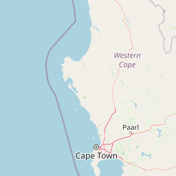
Map view of Rocherpan Nature Reserve

Use this park location map to pinpoint Rocherpan Nature Reserve in South Africa, understand its exact geographic position, and read its mapped placement within the surrounding landscape more clearly.

Pigeon | © OpenStreetMap contributors

Location context for Rocherpan Nature Reserve

Western Cape
Park atlas

Compare adjacent West Coast landscapes, wetland habitats, and regional reserves

Explore Parks Near Rocherpan Nature Reserve and Surrounding Coastal Protected Areas

Continue browsing other parks near Rocherpan Nature Reserve to compare regional coastal ecosystems, seasonal lagoons, and dune strandveld habitats. Expanding the geographic view helps connect individual wetland reserves with broader protected landscapes across the surrounding region.
National parkWestern Cape
About 50 km away#1 closest

South

West Coast National Park: A National Park's Mapped Boundaries and Geographic Identity

Explore its protected landscape within the Western Cape region.

West Coast National Park is a protected national park situated in the Western Cape province of South Africa. This dedicated page provides a structured view of its geographic scope, emphasizing its mapped boundaries and its significance as a protected landscape within the region's broader atlas context. Gain insight into the park's distinct natural terrain and regional geography.

Area
362.59 km²
Established
1985
Climate
Mediterranean
Access
Easy access
Nature reserveWestern Cape
About 58 km away#2 closest

North

Bird Island Nature Reserve: Mapped Coastal Protected Areas and Seabird Habitats

Geography and protected island landscapes in Western Cape, South Africa

Bird Island Nature Reserve represents a key protected coastal landform off the West Coast of South Africa. This three hectare reserve functions as a critical nesting ground, characterized by flat rocky shelves and sun-bleached outcrops. Browse the mapped boundaries and geographic features of this marine sanctuary, which plays a major role in regional seabird conservation and coastal ecological study.

Area
0.03 km²
Established
1988
Relief
Lowland
Climate
Mediterranean
A watercolor illustration of a scenic wilderness landscape with rolling hills, a winding stream, foreground grasses, and a distinct rock arch formation in the background.
Wildlife reserveWestern Cape
About 80 km away#3 closest

Northeast

Cederberg Wilderness Area: Geographic Overview of Western Cape Protected Landscapes

Mapped sandstone peaks and diverse fynbos wilderness.

The Cederberg Wilderness Area represents a rugged mountain range defined by its resistant Peninsula Formation sandstone and complex geological history. Encompassing dramatic rock formations, ancient caves, and unique botanical endemics, the area offers a study in the intersection of mountainous terrain and the Cape Floral Region. Understand the regional context and physical geography that shape this protected sanctuary.

Area
710 km²
Established
1973
Relief
Mountain
Climate
Mediterranean
A horizontal watercolor painting showing a soft, stylized mountain landscape with green hills, purple shadows, and grassy foreground.
Wildlife reserveWestern Cape
About 88 km away#4 closest

Southeast

Groot Winterhoek Wilderness Area: Protected Mountain Reserve in the Western Cape

Mapping sandstone ridges, fynbos plateaus, and mountain river systems

Spanning 30,000 hectares, Groot Winterhoek Wilderness Area represents a core mountain wilderness in South Africa. Its dissected landscape of Table Mountain sandstone features high peaks, sheltered kloofs, and seasonal rockpools, forming a critical ecological corridor and water catchment within the Cape Fold Belt mountain system.

Area
306.08 km²
Relief
Mountain
Climate
Mediterranean
Access
Moderate access
A watercolor painting showing a soft, panoramic landscape with green hills in the background, a body of water in the middle ground, and grasses in the foreground.
Nature reserveWestern Cape
About 90 km away#5 closest

South

Dassen Island Nature Reserve: Atlantic Geography and Protected Area Overview

Coastal refuge and protected granite-based Atlantic island

Located in the cold waters off the Western Cape, Dassen Island is a proclaimed nature reserve and Ramsar wetland. This flat Atlantic landmass is characterized by its granitic reef structure and long-established role as a sanctuary for African penguins and other seabird populations. The island represents a convergence of maritime history and marine conservation, offering a unique geographic perspective on South Africa's coastal wilderness.

Area
2.6 km²
Established
2019
Relief
Lowland
Climate
Mediterranean
Nature reserveWestern Cape
About 102 km away#6 closest

East

Matjiesrivier Nature Reserve: Botanical Diversity and San Rock Art in Western Cape

A protected landscape bridging fynbos and karoo ecosystems

Matjiesrivier Nature Reserve represents a critical conservation landscape in South Africa, known for the transition between mountain terrain and semi-arid basins. The reserve protects unique slate-based soil habitats that sustain a blend of Cape Floral Kingdom vegetation and hardy karoo species. Visitors and researchers recognize this area for its high density of San rock art sites, offering a deep cultural look into the Late Stone Age history of the Western Cape.

Area
128 km²
Established
1995
Water
Minor water
Nature reserveWestern Cape
About 115 km away#7 closest

South

Koeberg Nature Reserve: A Geographical Overview of Coastal Protected Landscapes

Lowland fynbos, dune thicket, and aquifer geography in the Western Cape

Situated north of Cape Town, Koeberg Nature Reserve acts as a vital sanctuary for threatened plant communities and diverse bird populations. Its unique terrain combines sandy coastal dunes with seasonal pans and wetland complexes, providing a distinct study in protected area conservation and regional ecological management.

Area
26.81 km²
Established
1991
Relief
Lowland
Climate
Mediterranean
Watercolor illustration showing a mountain range with green hills and pink flowers
National parkNorthern Cape
About 133 km away#8 closest

East

Tankwa Karoo National Park National Park: Mapped Protected Landscape in Northern Cape

Explore regional geography and protected area boundaries.

Tankwa Karoo National Park is a key protected area situated in the vast Northern Cape region of South Africa. This entry provides a detailed atlas perspective, focusing on the park's mapped geography and its significance as a national park. Understand the park's landscape context and its position within the broader regional geography for informed exploration and geographic discovery.

Area
1,436 km²
Established
1986
Relief
Upland
Climate
Arid

Common questions about visiting, size, designation, and location context for Rocherpan Nature Reserve

Rocherpan Nature Reserve FAQs for park facts, access, geography, and protected area context

Find quick answers about Rocherpan Nature Reserve, including protected-area facts, park geography, trail and visitor context, and how the park fits into its surrounding country and regional landscape.
MoriAtlas Explorer

Continue Your Protected Areas Search Across the Global Atlas

Deepen your exploration by continuing the structured search for national parks and protected areas worldwide. Utilize the comprehensive filtering capabilities to compare different conservation landscapes and refine your understanding of global park geography. Discover more about the distribution and characteristics of protected natural areas.

Global natural geography