Mori Atlas logo
Nature reserveRohrsee von Rehbach

A crucial wetland biotope and waterbird habitat within the rolling topography of southern Hesse.

Rohrsee von Rehbach Nature Reserve: Mapped Protected Landscapes in the Sandstein Odenwald

(Naturschutzgebiet „Rohrsee von Rehbach“)

Rohrsee von Rehbach represents a protected mosaic of shallow artificial water, dense reed belts, and wet meadows situated in the sandstone Odenwald region of Germany. This compact nature reserve provides essential breeding and resting habitats for diverse waterbird species. Our map-based atlas highlights the site's hydrologic connections to the Rehbach stream and its role as a concentrated sanctuary within the broader, drier forested landscape of the Odenwaldkreis.

wetlandnature reservereed bedspondswet meadowswaterbirds

Rohrsee von Rehbach

Nature reserve

Park overview

Structured park overview, official facts, and landscape profile for Rohrsee von Rehbach

Rohrsee von Rehbach park facts, protected area profile, and essential visitor context

Review the core facts for Rohrsee von Rehbach, including designation, size, terrain, visitor scale, habitats, and operating context in one park-focused overview.

About Rohrsee von Rehbach

Rohrsee von Rehbach is a compact but ecologically focused nature reserve in the Odenwald region of southern Hesse. It lies in the Gemarkung of Rehbach, just southwest of the village of Rehbach itself and about five kilometers northwest of the main town of Michelstadt. The reserve occupies a modest footprint of around 15.57 hectares, yet its conservation significance is disproportionately large relative to its size because it preserves a habitat type that is otherwise scarce in this part of Germany.

The landscape of the surrounding area belongs to the Sandstein-Odenwald, a subregion of the Odenwald characterized by sandstone geology, predominantly forested terrain, and relatively dry soils. Within that setting, the Rohrsee wetland stands out as a soft, water-dominated pocket. The Rehbach stream, a left tributary of the Mümling river, flows through the protected area, while the Bundesstraße 47 runs along its northern edge.

The habitat mosaic at the heart of the reserve includes an artificially created shallow pond, dense reed (Röhricht) stands, sedge communities, and adjoining wet meadows. This mix of open water, emergent vegetation, and grassland provides structural diversity in a small space, supporting a wide range of plant and animal species. The reserve has been protected since November 1986 and is managed under the framework of German nature conservation law, with a supplementary ordinance issued in September 1993 refining its management provisions.

Quick facts and research context for Rohrsee von Rehbach

Rohrsee von Rehbach is a nature reserve of approximately 15.57 hectares in the municipality of Michelstadt, Odenwaldkreis, Hesse. It was designated on November 24, 1986 under the official identifier 1437007, with an amended ordinance in 1993, and is recorded in the World Database on Protected Areas under WDPA ID 165212. The reserve lies at elevations between roughly 276 and 288 meters and is classified as an IUCN Category IV Habitat/Species Management Area. The protected landscape centers on an artificial pond, reed beds, sedge communities, and adjacent wet meadows along the Rehbach stream, a left tributary of the Mümling.

Protection and recognition

Examine the verified conservation standing and official database records

Protection Status and International Recognition for Rohrsee von Rehbach

Consolidated protection records provide clear insights into the administrative framework governing Rohrsee von Rehbach. Structured data profiles trace the official conservation standing and international database attribution assigned to the protected area.

Protection details

WDPA ID
165212
Park context

Deeper park guide and search-rich context for Rohrsee von Rehbach

Rohrsee von Rehbach history, landscape, wildlife, and travel context

Explore Rohrsee von Rehbach through its history, landscape character, ecosystems, wildlife, conservation priorities, cultural context, and seasonal travel timing in a structured park guide built for atlas discovery and search intent.

Why Rohrsee von Rehbach stands out

Rohrsee von Rehbach is best known as a valuable wetland biotope within the otherwise dry Sandstein-Odenwald. Its combination of a shallow man-made pond, a well-developed reed belt, sedge stands, and surrounding wet meadows creates a habitat that is uncommon in the sandstone Odenwald and is particularly important for waterbirds.
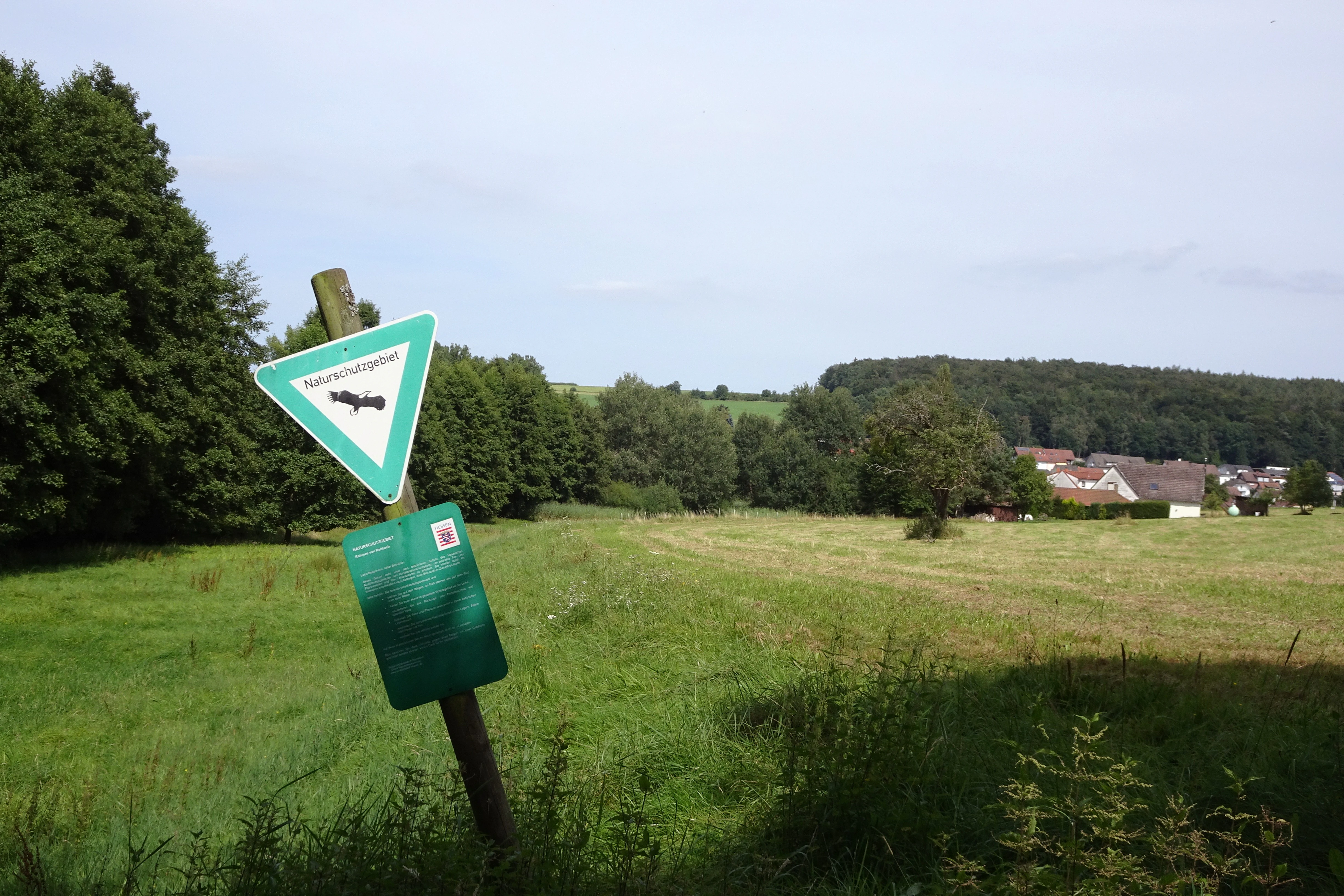
A wooden post with a green triangular sign featuring a bird silhouette and a rectangular information board stands in a grassy field. Trees, a forested hill, and houses are visible in the distance under a cloudy sky.
A green nature reserve sign for Rohrsee von Rehbach stands in a grassy meadow, with a forested hill and village houses visible in the background.

Rohrsee von Rehbach history and protected-area timeline

Rohrsee von Rehbach has been formally protected as a Naturschutzgebiet since November 24, 1986, when it was designated under the identifier 1437007. The ordinance establishing the reserve recognized the wetland's value as a refuge for plants and animals in an otherwise predominantly sandstone and forested landscape. A supplementary ordinance on September 20, 1993 amended and refined the protection framework, suggesting ongoing adjustments to the management of the site. Beyond these key administrative milestones, the pond itself is described as artificially created, indicating that the open water element of the habitat is the result of deliberate historical land management rather than a purely natural feature.

Rohrsee von Rehbach landscape and geographic character

The reserve lies in a gently rolling section of the Sandstein-Odenwald, where the broader landscape is shaped by sandstone bedrock, mixed forest cover, and small stream valleys. Within this setting, the protected area itself is defined by soft, low-lying terrain dominated by open water and moist ground. The central feature is a shallow, flat-bottomed pond with a marked reed belt (Schilfgürtel), bordered by stands of sedges and wet meadows.

The Rehbach stream, a left-hand tributary of the Mümling, flows through the area, providing hydrological connection between the pond and the wider drainage network. Elevations within the reserve range from roughly 276 to 288 meters above sea level, and the gentle topography allows water to persist at the surface, supporting the continuous presence of wetland vegetation. To the north, the Bundesstraße 47 forms a clear linear boundary, while the surrounding hillsides remain forested in the typical Odenwald manner.

Rohrsee von Rehbach ecosystems, habitats, and plant life

Rohrsee von Rehbach preserves a wetland habitat complex that is unusual in the Sandstein-Odenwald. The protected area combines a shallow artificial pond, extensive reed (Röhricht) stands, sedge communities, and adjacent wet meadows, creating a layered habitat that includes open water, emergent vegetation, marshland, and seasonally moist grassland.

This habitat mosaic supports a mix of aquatic, marsh-loving, and grassland species in close proximity, which is ecologically rare in a region dominated by dry sandstone soils and beech or mixed forests. The intentional inclusion of the artificial pond adds an open-water component that would otherwise be largely absent in this landscape, while the reed belt and sedge stands provide the structural complexity needed for nesting cover and foraging habitat.

Rohrsee von Rehbach wildlife and species highlights

The reserve's particular value lies in its role for waterbirds. The shallow pond, the surrounding reed belt, and the wet meadows together function as a breeding, feeding, and resting area for a range of bird species, some of which are considered rare or threatened. By providing this combination of open water for waterfowl, dense reeds for nesting cover, and adjacent moist meadows for foraging, the site acts as a compact bird refuge within a landscape that generally offers fewer wetland opportunities.

Rohrsee von Rehbach conservation status and protection priorities

Rohrsee von Rehbach is designated as a Naturschutzgebiet under German nature conservation law and is classified internationally as an IUCN Category IV Habitat/Species Management Area. Its protection focuses specifically on the preservation of a wetland biotope and on maintaining viable habitats for a broad range of plant and animal species, with particular emphasis on waterbirds using the site for breeding, feeding, and resting.

Because wetland conditions are scarce in the Sandstein-Odenwald, the reserve has a disproportionate role in maintaining regional biodiversity, supporting both aquatic and marsh-associated flora and fauna that would otherwise struggle to find suitable habitat in the surrounding sandstone terrain.

Top sights and standout views in Rohrsee von Rehbach

The reserve combines a shallow artificial pond with a pronounced reed belt and adjacent wet meadows in the heart of the sandstone Odenwald. It functions as an important breeding, feeding, and resting site for waterbirds in a region where wetland habitat is otherwise limited. With its compact area of about 15.57 hectares, it demonstrates how small, well-targeted protected sites can play an outsized role in regional biodiversity conservation.

Best time to visit Rohrsee von Rehbach

The reserve can be experienced across the seasons, but late spring and early summer are typically the most rewarding times for observing reedbed and waterbird activity, when nesting, feeding, and vegetation growth are at their peak. Wet meadows and reeds also take on strong visual character in this period, while autumn can bring migratory use of the wetland as a resting and feeding stop.

Monthly climate preview

Long-term representative monthly temperature averages and precipitation totals for Hesse

Rohrsee von Rehbach Climate Normals, Annual Temperature and Precipitation Rhythm

Historical climate records for Rohrsee von Rehbach indicate steady monthly variations in average temperature and precipitation across a standard multi-year period. Examining the comprehensive twelve-month profile provides deeper analytical clarity regarding local meteorological patterns at the sampled elevation coordinate.
Annual mean10 °C
0 °C20 °C
Jan
Feb
Mar
Apr
May14°
Jun18°
Jul20°
Aug20°
Sep15°
Oct10°
Nov
Dec
Warmest month
July

20.3 °C

Coolest month
January

0.1 °C

Wettest month
July

2.4 mm/day

Driest month
April

1.5 mm/day

Park location guide

Geography guide, regional context, and park location map for Rohrsee von Rehbach

Rohrsee von Rehbach park geography, regions, and map view in Germany

Understand where Rohrsee von Rehbach sits in Germany through a broader geographic reading of the surrounding landscape, nearby location context, and its mapped position within the national park landscape.

How Rohrsee von Rehbach fits into Germany

Germany is a federal republic in Western and Central Europe with a population of over 83 million across sixteen constituent states. It is Europe's largest economy by nominal GDP and a major global exporter and importer. The capital is Berlin, and the country borders Denmark, Poland, Czech Republic, Austria, Switzerland, France, Luxembourg, Belgium, and the Netherlands.

Wider geography shaping Rohrsee von Rehbach in Germany

Germany is located in Western and Central Europe, spanning 357,022 km². It borders Denmark to the north, Poland and the Czech Republic to the east, Austria and Switzerland to the south, and France, Luxembourg, Belgium, and the Netherlands to the west. The country has coastlines on the Baltic Sea and North Sea to the north, with the Alps located in the southern region.

Map view of Rohrsee von Rehbach

Use this park location map to pinpoint Rohrsee von Rehbach in Germany, understand its exact geographic position, and read its mapped placement within the surrounding landscape more clearly.

Pigeon | © OpenStreetMap contributors

Location context for Rohrsee von Rehbach

Hesse

Visual reference collection highlighting protected wetland terrain and regional park environments.

Rohrsee von Rehbach Photos: Scenery, Wetland Habitats, and Landscape Views

Visual documentation captures the shallow pond waters, dense reed beds, and moist meadows that define the protected landscape of Rohrsee von Rehbach. Examining these habitat views helps researchers and visitors understand the distinctive ecological character of this sandstone Odenwald wetland reserve.

A wooden post with a green triangular sign featuring a bird silhouette and a rectangular information board stands in a grassy field. Trees, a forested hill, and houses are visible in the distance under a cloudy sky.

Park atlas

Discover related wetland biotopes and regional park geography across the sandstone Odenwald

Explore Protected Areas and Nature Reserves Near Rohrsee von Rehbach

Compare Rohrsee von Rehbach with other protected landscapes and wetland reserves located throughout the surrounding region. Broaden your geographic exploration by examining adjacent valley biotopes and regional conservation areas.
A soft watercolor painting of a wetland landscape with rolling hills in the background, a body of water in the middle, and green grass in the foreground.
Nature reserveHessen
About 6.1 km away#1 closest

Northeast

Bruch von Bad König und Etzen-Gesäß: Nature Reserve and Floodplain Geography

Protected wetland landscapes in the Odenwald region of Hessen

Located along the Mümling river, this nature reserve protects a vital network of moist meadows, reed beds, and softwood forests. The site offers a clear view into the alluvial geography of the Odenwald, showcasing how protected floodplain corridors function within a developed regional landscape.

Area
0.427 km²
Established
1980
IUCN
IV
Relief
Lowland
A watercolor illustration of a soft, pastel-colored wetland landscape with trees, grassy banks, and distant hills.
Nature reserveHesse
About 8.4 km away#2 closest

Northwest

Bruch von Brensbach: Mapping the Nature Reserve and Wetland Mosaic in Hesse, Germany

Protected carr woodland and Gersprenz valley stream corridors

Located in the Odenwaldkreis district of Hesse, Bruch von Brensbach acts as a crucial protected wetland corridor. The reserve preserves a rare concentration of alder carr forest and reed beds along the Kilsbach stream, offering a stark geographic contrast to the agricultural fields that characterize the broader Gersprenz valley landscape.

Area
0.055 km²
Established
1983
IUCN
IV
A horizontal watercolor illustration of a soft, rolling landscape with a central winding path or stream, green meadows, distant hills, and foreground trees and flowers.
Nature reserveHesse
About 9.7 km away#3 closest

Southwest

Gras-Ellenbacher Wiesen Nature Reserve: Protected Valley Basin Geography and Map Overview

Wet meadows and seepage habitats within the Odenwald hills

Situated in a gentle hollow near the Dachsberg and Kirchberg ridges, Gras-Ellenbacher Wiesen represents an essential Hessian nature reserve. This overview highlights the interplay between the Ulfenbach stream, drainage infrastructure, and traditional meadow management that defines this distinct sandstone upland protected landscape.

Area
0.241 km²
Established
1981
IUCN
IV
Relief
Upland
A wide watercolor painting showing rolling green hills and trees with pale pink and yellow hues across a valley landscape.
Nature reserveHessen
About 12 km away#4 closest

Southwest

Rotes Wasser von Olfen Nature Reserve: Protected Wetland and Odenwald Geography

A unique bog and iron-rich stream landscape in Hessen, Germany.

Rotes Wasser von Olfen preserves a rare, small-scale mosaic of transitional bog and wet meadow vegetation within the Odenwald range. This protected site features reddish, iron-rich seepage waters and provides essential habitat for specialized flora and dragonfly populations amidst a surrounding forested mountain landscape.

Area
0.121 km²
Established
1980
IUCN
IV
Relief
Upland
A horizontal watercolor illustration depicting a meandering stream through green valley meadows, flanked by soft foliage and rolling hills in the background.
Nature reserveOdenwaldkreis
About 12 km away#5 closest

East

Geierstal von Vielbrunn Nature Reserve: Odenwald Landscape and Geography

Protected brook valley and floodplain ecosystems

Geierstal von Vielbrunn is a distinct nature reserve in Odenwaldkreis, characterized by a narrow valley floor carved by the Ohrenbach stream. The site preserves rare sedge fens, tall herb communities, and black alder galleries that provide essential refuge for regional wildlife. This protected landscape highlights the complex ecological transition between Hessian and Bavarian forest zones in a compact, valley-bottom geography.

Area
0.16 km²
Established
2000
Relief
Upland
Climate
Temperate
Watercolor painting of a wide, low-horizon landscape featuring a line of green trees against a pale pink sky over a pale, sandy foreground.
Nature reserveHessen
About 13 km away#6 closest

North

Sandsteinbrüche am Burzelberg bei Frau-Nauses Protected Nature Reserve and Quarry Atlas

Odenwald mountain range, Hessen protected area

Examine the geography of Sandsteinbrüche am Burzelberg bei Frau-Nauses, a protected nature reserve in Hessen. This site features striking Buntsandstein quarry walls and rewilded forest edges, providing a specialized environment for cliff-nesting raptors and documenting local industrial history through its geological formations.

Area
0.195 km²
Established
1994
Relief
Upland
Climate
Temperate
A soft watercolor illustration depicting a green, hilly landscape with meadows and distant low slopes on a white background.
Nature reserveHesse
About 14 km away#7 closest

Northwest

Forstberg von Ueberau: A Volcanic Nature Reserve and Protected Landscape in Hesse, Germany

Geographic atlas of an extinct volcano and dry grassland refuge.

Forstberg von Ueberau serves as a vital ecological anchor within the Reinheimer Hügelland. This 30-hectare nature reserve preserves an unusual volcanic substrate, featuring a crater-shaped basalt quarry surrounded by seminatural meadows and hedgerows. The site stands as a prime example of habitat management where traditional agricultural practices and biodiversity protection converge to sustain Red List species in a structured, open-country setting.

Area
0.305 km²
Established
1990
IUCN
IV
A horizontal watercolor illustration of a soft green landscape with meadows, scattered trees, and distant rolling hills under a pale pink sky.
Nature reserveHessen
About 17 km away#8 closest

West

Schannenbacher Moor Nature Reserve: Geographic Overview and Protected Area Boundaries

Wetland and forest mosaic in the southern Hessian Odenwald

Schannenbacher Moor represents a significant protected area within Hessen, characterized by its combination of raised bog remnants, reedbeds, and near-natural floodplain woodlands. Framed by the Krehberg slopes and the Meerbach stream system, the reserve offers a rare example of low mountain bog ecology and biodiversity conservation. This mapped landscape provides essential data on the distribution of mire plant communities and bryophyte habitats in the region.

Area
0.162 km²
Established
1975
IUCN
IV

Common questions about visiting, size, designation, and location context for Rohrsee von Rehbach

Rohrsee von Rehbach FAQs for park facts, access, geography, and protected area context

Find quick answers about Rohrsee von Rehbach, including protected-area facts, park geography, trail and visitor context, and how the park fits into its surrounding country and regional landscape.
MoriAtlas Explorer

Continue Your Protected Areas Search Across the Global Atlas

Deepen your exploration by continuing the structured search for national parks and protected areas worldwide. Utilize the comprehensive filtering capabilities to compare different conservation landscapes and refine your understanding of global park geography. Discover more about the distribution and characteristics of protected natural areas.

Global natural geography