
Mori Atlas logo
Protected areaRongelap Atoll

A classic coral atoll structure of 61 narrow islands encircling a vast Pacific lagoon.

Rongelap Atoll Protected Area: Mapping the Geographic and Historical Landscape of the Marshall Islands

Rongelap Atoll stands as a central geographic feature of the Ralik Chain within the Marshall Islands. Composed of 61 small coral motus, the landscape forms a massive lagoon boundary typical of low-lying Pacific atolls. Beyond its reef-built terrain, the atoll represents a profound intersection of Micronesian settlement history and 20th-century geopolitical events within the North Pacific region.

coral atollMarshall IslandsRalik ChainPacific atollsnuclear historyCastle Bravo fallout
A flat-style digital illustration showing a mountain valley landscape with steep cliffs, a waterfall cascading down the rock face, a winding river in the foreground, and evergreen trees.

Rongelap Atoll

Protected area

Park overview

Structured park overview, official facts, and landscape profile for Rongelap Atoll

Rongelap Atoll park facts, protected area profile, and essential visitor context

Review the core facts for Rongelap Atoll, including designation, size, terrain, visitor scale, habitats, and operating context in one park-focused overview.

About Rongelap Atoll

Rongelap Atoll is one of the many low-lying coral atolls that make up the Ralik Chain in the western Marshall Islands. Its 61 islands form a broken ring around a vast central lagoon, and like other atolls in the region, it represents the slow biological accumulation of coral reef material on top of a subsiding volcanic foundation. The motus are small, sandy, and rarely rise more than a few meters above the ocean, and the surrounding waters are part of the broader tropical Pacific reef ecosystem.

What sets Rongelap apart among Marshallese atolls is not the atoll's natural setting alone, which is broadly shared with neighboring Rongerik, Utirik, Ailinginae, and Toke atolls, but its 20th-century history. The atoll was within the broader range of U.S. nuclear testing at Bikini and Kwajalein, and its people became subjects in the study of radioactive fallout on human bodies. The 1954 Castle Bravo test spread contamination across thousands of square kilometers of ocean, depositing irradiated material directly onto Rongelap's inhabited islands.

The atoll's significance today spans multiple dimensions. Geographically, it remains an example of an uninhabited Marshallese atoll shaped by reef and lagoon dynamics. Historically, it documents the relocation, return, illness, and eventual departure of an entire community under the pressure of nuclear contamination. Politically, it became a focus of late-C20th and early C21st discussions about compensation, cleanup verification, outside investment, and ultimately the contested arrival of foreign capital through a proposed special economic zone lease.

Quick facts and research context for Rongelap Atoll

Rongelap Atoll lies in the Ralik Chain of the Marshall Islands in the North Pacific Ocean and administratively forms its own legislative district. The atoll consists of 61 motus with a combined land area of about 21 square kilometers, enclosing an enormous lagoon of roughly 2,600 square kilometers. Its highest point is only about 3 meters above sea level, typical of low coral atolls in the region.

The atoll is historically significant as one of the communities most affected by the 1954 Castle Bravo hydrogen bomb test, and its modern identity is shaped by evacuation, forced return, eventual relocation with Greenpeace's Rainbow Warrior, and later compensation and resettlement discussions involving the United States government and outside investors.

Protection and recognition

Marine conservation framework and recognized protected area designation details

Rongelap Atoll Protection Status and Marine Protected Area Designation

Rongelap Atoll maintains a documented marine protection scope within its regional conservation framework. Recorded records outline international recognition sources and management status parameters for the protected territory.

Protection details

Protection scope
Marine
Transboundary protection
No
Park context

Deeper park guide and search-rich context for Rongelap Atoll

Rongelap Atoll history, landscape, wildlife, and travel context

Explore Rongelap Atoll through its history, landscape character, ecosystems, wildlife, conservation priorities, cultural context, and seasonal travel timing in a structured park guide built for atlas discovery and search intent.

Why Rongelap Atoll stands out

Rongelap Atoll is best known as the inhabited Marshallese community whose residents were exposed to heavy radioactive fallout from the 1954 Castle Bravo nuclear test, the detonation that produced fallout extending across the surrounding Pacific. The atoll's name became internationally associated with questions about nuclear testing ethics, informed consent, and the long-term consequences of fallout exposure on small island populations. It is also known for being the site of the 1985 Greenpeace 'Operation Exodus,' one of the most prominent examples of an environmental organization physically relocating an entire community, moving hundreds of people along with their homes and belongings to Mejato and Ebeye on Kwajalein Atoll.
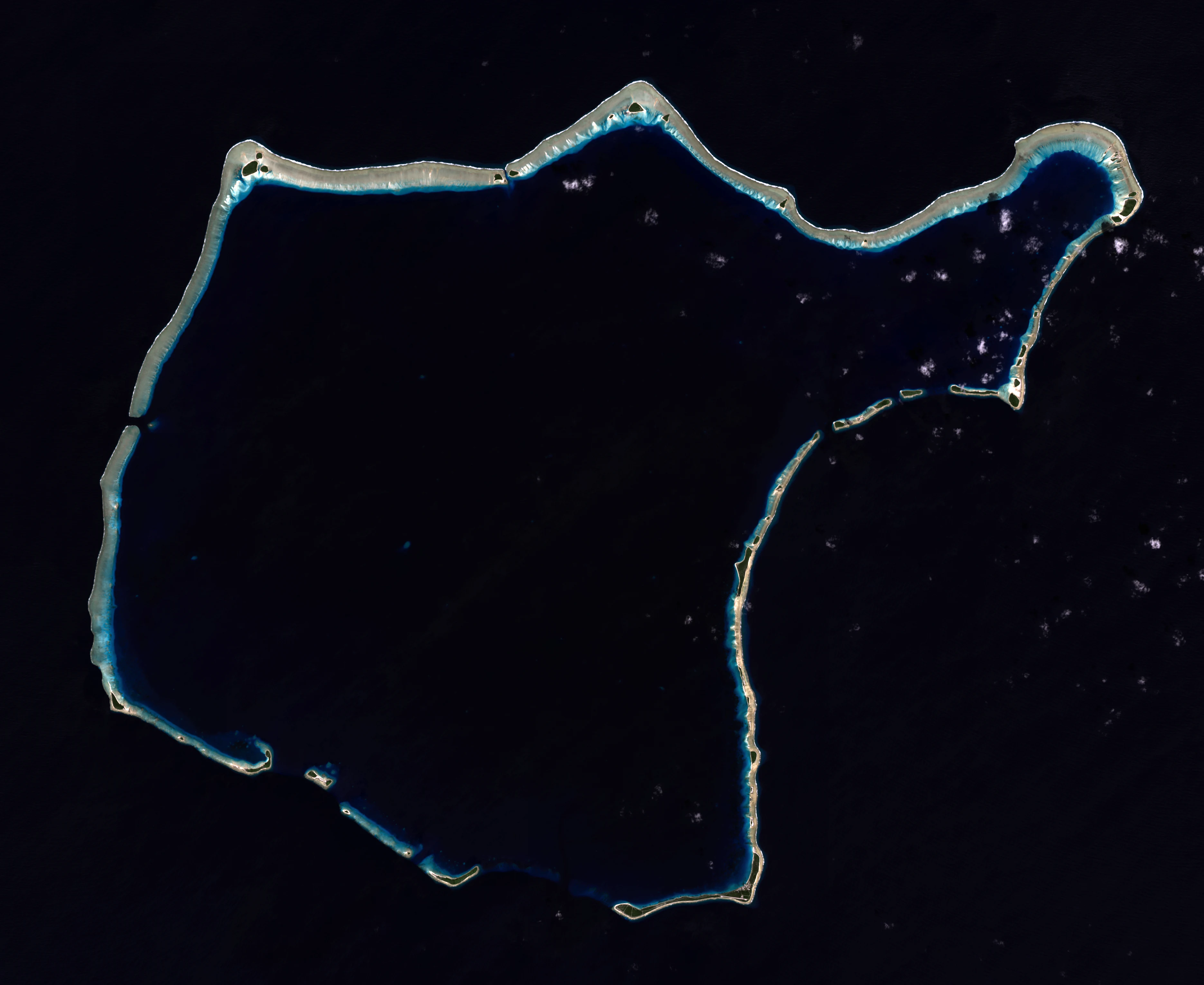
Satellite view of a coral atoll showing a ring of islands and reefs surrounding a central dark blue lagoon against a deep black ocean background.
A true color Landsat 8 satellite view of Rongelap Atoll in the Marshall Islands.

Rongelap Atoll history and protected-area timeline

The Marshall Islands were originally settled by Micronesian voyagers long before European contact, with Rongelap incorporated into this broader settlement pattern. The first recorded European sighting came in 1528, when Spanish navigator Álvaro de Saavedra charted Rongelap together with neighboring atolls as the Islas de los Reyes because of the proximity of the Epiphany holiday. Fourteen years later the Spanish expedition of Ruy López de Villalobos revisited the area.

In 1885 the atoll was claimed by the German Empire alongside the rest of the Marshall Islands. After the First World War it passed to the Empire of Japan under the South Seas Mandate, and after the Second World War it became part of the United States-administered Trust Territory of the Pacific Islands.

The defining chapter of Rongelap's modern history began with the U.S. atmospheric nuclear testing program. On 1 March 1954, the Castle Bravo hydrogen device at Bikini Atoll detonated far more powerfully than predicted, and fallout drifted onto Rongelap. Inhabitants fell ill with radiation sickness, were evacuated days later, and were later subjected to medical observation under what became known as Project 4.1. Despite warnings about contamination, the U.S. government returned the population in 1957 as part of a study of long-term human radiation effects. Continued thyroid disease, leukemia, miscarriages, and stillbirths led the community to seek international help.

In 1985, with the support of the environmental organization Greenpeace, the entire Rongelapese community was relocated to Mejato and Ebeye on Kwajalein Atoll aboard the Rainbow Warrior. The resettlement, known as 'Operation Exodus,' moved roughly 350 people and around 100 metric tons of building material over ten days. In 1991 the People of Rongelap and Senator Jeton Anjain received the Right Livelihood Award for their campaign against U.S. nuclear policy affecting their homeland. Later decades brought a 1996 compensation agreement, 2014 verification measurements suggesting improved radiation levels, debate about cleanup feasibility, and a 2019 Chinese-backed lease proposal that collapsed after the investor's arrest.

Rongelap Atoll landscape and geographic character

Rongelap is a classic low coral atoll, made up of 61 small islands, or motus, that together cover around 21 square kilometers of land and enclose a lagoon of roughly 2,600 square kilometers. Maximum elevation is only about 3 meters, reflecting the typical thin profile of reef-built Pacific atolls.

The motus themselves are narrow accumulations of coral sand and rubble, often vegetated with hardy coastal species adapted to salt spray and shifting substrates. Surrounding reefs shelter the lagoon and the open ocean edge, giving the atoll a structure of alternating land, reef rim, and deep lagoon typical of the Ralik Chain.

Rongelap Atoll ecosystems, habitats, and plant life

As a low-lying Pacific atoll, Rongelap is shaped primarily by its coral reef ecosystem, sandy motus, and vast enclosed lagoon. Its natural character reflects the broader ecology of the Ralik Chain: reef habitats, lagoon sand and patch-reef environments, and open ocean waters sheltering species typical of Micronesian reef systems.

The sources currently available do not provide detailed ecological inventories of atoll flora and fauna, so any deeper description of endemic or characteristic species would risk speculation.

Rongelap Atoll wildlife and species highlights

The atoll's biological context is consistent with reef and lagoon ecosystems across the Marshall Islands, including typical marine life associated with healthy Pacific coral atolls. However, the Wikipedia source does not provide documented details about specific birdlife, fish, or terrestrial fauna characteristic of Rongelap, so further species-level claims cannot be reliably made here.

Rongelap Atoll conservation status and protection priorities

Rongelap's conservation significance is fundamentally linked to its radioactive contamination history. The U.S. Department of the Interior signed a 1996 resettlement agreement with the islanders that included cleanup steps, and independent measurements in August 2014 reportedly verified safe radiation levels. However, the cleanup approach has been criticized as impractical, and debates over the atoll's long-term ecological integrity continue. Outside conservation issues, the proposal and abandonment of a large foreign-leased special economic zone illustrates how contemporary economic and geopolitical pressures intersect with the atoll's environment.

Rongelap Atoll cultural meaning and human context

Rongelap's cultural importance rests on its place within the broader Marshallese settlement of the Ralik Chain and on the community's distinctive modern history. The 1985 relocation to Mejato and Ebeye effectively transferred the Rongelapese community, including elders and newborns, into an unfamiliar atoll environment, where overcrowding and unemployment became significant challenges.

In 1991 the People of Rongelap and Senator Jeton Anjain received the Right Livelihood Award for their international advocacy. The community's resettlement and the ongoing debates over return, cleanup, compensation, and outside investment together form a major chapter in late-20th and early-21st century Marshallese political and cultural history.

Top sights and standout views in Rongelap Atoll

Rongelap Atoll stands out as a striking combination of classic Pacific atoll geography and one of the most consequential nuclear histories of the modern era. It is defined by 61 motus, a vast enclosed lagoon, and the unmistakable imprint of the Castle Bravo fallout event of 1954.

The atoll is also notable for Operation Exodus, the 1985 Greenpeace-led relocation of an entire community, and for the post-evacuation debates about compensation, radiation verification, and outside investment that continue to shape its future.
Monthly climate preview

Long-term monthly temperature averages and precipitation patterns for Rongelap Atoll

Rongelap Atoll Climate Normals, Annual Temperature and Precipitation Rhythm

Representative baseline coordinates record consistent mean temperatures spanning from 26.75 degrees Celsius to 28.11 degrees Celsius alongside varying monthly precipitation totals. Detailed historical data comparisons reveal the complete twelve-month climatological progression across the atoll.
Annual mean28 °C
27 °C28 °C
Jan27°
Feb27°
Mar27°
Apr27°
May28°
Jun28°
Jul28°
Aug28°
Sep28°
Oct28°
Nov28°
Dec28°
Warmest month
October

28.1 °C

Coolest month
February

26.8 °C

Wettest month
October

5.1 mm/day

Driest month
February

0.8 mm/day

Park location guide

Geography guide, regional context, and park location map for Rongelap Atoll

Rongelap Atoll park geography, regions, and map view in Marshall Islands

Understand where Rongelap Atoll sits in Marshall Islands through a broader geographic reading of the surrounding landscape, nearby location context, and its mapped position within the national park landscape.

How Rongelap Atoll fits into Marshall Islands

The Marshall Islands is a sovereign island nation in Oceania, located in the Micronesia region of the Northwestern Pacific Ocean. The territory consists of 29 coral atolls and five main islands plus over 1,200 very small ones, divided across two island chains: Ratak in the east and Ralik in the west. The country gained independence from the United States in 1979 and maintains a Compact of Free Association with the US. It is notable for having the highest proportion of water to land of any sovereign state, at 98.62%.

Wider geography shaping Rongelap Atoll in Marshall Islands

The Marshall Islands is located in the Micronesia region of the Northwestern Pacific Ocean, west of the International Date Line and north of the equator. The territory is composed of 29 coral atolls and five main islands, plus approximately 1,220 very small islets, divided into two island chains: Ratak (eastern) and Ralik (western). Maritime boundaries are shared with Wake Island to the north, Kiribati to the southeast, Nauru to the south, and the Federated States of Micronesia to the west.

Map view of Rongelap Atoll

Use this park location map to pinpoint Rongelap Atoll in Marshall Islands, understand its exact geographic position, and read its mapped placement within the surrounding landscape more clearly.

Pigeon | © OpenStreetMap contributors

Visual reference of coral motus, enclosed lagoons, and remote Pacific atoll terrain

Rongelap Atoll Photos and Protected Landscape Scenery

Examine detailed park photography showcasing the low coral islands, vast reef lagoons, and coastal habitats of Rongelap Atoll. Visual documentation provides essential geographic context for understanding the terrain, remote environment, and unique character of this Pacific reserve.

Satellite view of a coral atoll showing a ring of islands and reefs surrounding a central dark blue lagoon against a deep black ocean background.

An aerial, high-angle view of Rongelap Atoll in the Pacific Ocean, featuring a jagged, circular ring of coral reefs and islands against a deep blue sea with scattered white clouds.

Park atlas

Continue your geographic comparison across surrounding Pacific island landscapes.

Exploring Parks Near Rongelap Atoll and Related Protected Areas

Compare Rongelap Atoll with other protected areas and coral reef systems across the surrounding region. Geographic comparison reveals broader patterns in remote island geography and conservation landscapes.
Protected areaMarshall Islands
About 52 km away#1 closest

West

Ailinginae Atoll Protected Area: Geographic Overview and Mapped Lagoon Systems

Remote coral atoll landscape in the Marshall Islands

Uncover the geographic structure of Ailinginae Atoll, an uninhabited coral ring in the Marshall Islands characterized by its expansive internal lagoon and narrow island segments. This protected area offers significant insight into the terrain of low-lying Pacific atoll ecosystems and their role within the Ralik Chain geographic framework.

Area
2.8 km²
Relief
Lowland
Water
Water-dominated
Protected areaMarshall Islands
About 73 km away#2 closest

East

Rongerik Atoll Protected Area: Mapping the Marshall Islands Coral Landscape

Remote coral atoll geography and lagoon structures in the Ralik Chain.

Rongerik Atoll presents a textbook example of Pacific atoll geography, where a cluster of small islets encloses an expansive lagoon. As a protected area located in the remote Marshall Islands, this site serves as a vital point of study for understanding coral reef systems and the isolated island terrain of the Ralik Chain. The landscape provides clear insights into the physical contrast between narrow coral landmasses and the deep interior waters characteristic of the region.

Area
1.68 km²
Relief
Lowland
Climate
Tropical
Access
Remote access
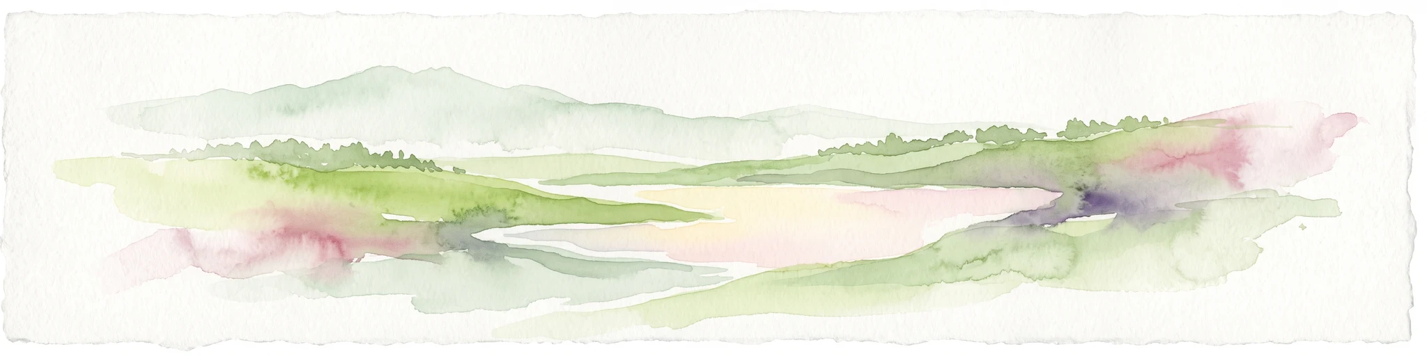
Watercolor painting of a landscape showing a body of water surrounded by green land with trees and distant hills, with soft pink and purple washes on the sides
Protected areaMarshall Islands
About 301 km away#3 closest

Southeast

Likiep Atoll: A Mapped Protected Area in the Marshall Islands Ratak Chain

Coral atoll geography and historical colonial landscape features

Likiep Atoll consists of 65 islands encircling a 424 square kilometer lagoon. As a protected area in the Marshall Islands, it offers insight into low lying atoll topography, unique marine environments, and the cultural remnants of successive colonial administrations.

Area
10.26 km²
Relief
Lowland
Climate
Tropical
Access
Remote access
A pale, soft watercolor illustration depicting distant islands or atoll ridges across a calm lagoon, with silhouetted palm trees in the foreground on the left and right.
Protected areaMarshall Islands
About 306 km away#4 closest

South

Kwajalein Atoll Protected Area and Marshall Islands Geographic Landscape Mapping

Pacific coral atoll structure and lagoon geography

Kwajalein Atoll represents a mature coral formation encompassing an immense lagoon within the Ralik Chain. The landscape consists of low-lying islets and interconnected reef structures that define the maritime geography of the Marshall Islands. This assessment provides a focus on the structural, mapped, and physical attributes that distinguish this protected site within the wider Pacific regional context.

Area
16.4 km²
Relief
Lowland
Climate
Tropical
Access
Highly restricted
Protected areaMarshall Islands
About 361 km away#5 closest

East

Ailuk Atoll Protected Area: Geography and Mapped Coral Landscapes in the Marshall Islands

Pacific atoll terrain, lagoon systems, and island geography

Study the geographic composition of Ailuk Atoll, featuring its classic ring of coral islets, deep-water reef passes, and vast central lagoon. This protected area offers insight into the subsidence-driven formation of Marshallese island chains and the enduring human reliance on traditional maritime navigation within a fragile Pacific ecosystem.

Area
5.4 km²
Relief
Lowland
Climate
Tropical
Access
Remote access
Protected areaMarshall Islands
About 379 km away#6 closest

East

Bikar Atoll Protected Area: Geographic Overview of a Remote Marshall Islands Coral Atoll

A pristine, uninhabited coral sanctuary and critical Pacific marine habitat.

Bikar Atoll is a remote, diamond-shaped coral ring located in the Ratak Chain of the Marshall Islands. Defined by its shallow lagoon, continuous reef structure, and arid islets, the atoll serves as a vital nesting site for seabirds and green turtles. This protected area remains one of the most ecologically undisturbed sites in the Pacific, offering rare insight into natural atoll morphology and island conservation.

Area
0.5 km²
Established
2025
Relief
Lowland
Climate
Tropical
Protected areaMarshall Islands
About 429 km away#7 closest

Northeast

Bokak Atoll Protected Area: Mapping the Northern Ratak Chain of the Marshall Islands

A remote coral atoll with a rare perched lagoon and pristine reef ecosystem

Bokak Atoll represents a primary example of an undisturbed central Pacific coral atoll, defined by its lack of introduced species and its striking perched lagoon. The landscape consists of low coral islets along a crescent reef, creating a specialized habitat for seabird colonies and stony coral reefs. This geographic overview examines the atoll's isolation and its status as a critical protected natural area within the wider Marshall Islands territory.

Area
129 km²
Relief
Lowland
Climate
Tropical
Access
Remote access
Protected areaMarshall Islands
About 647 km away#8 closest

South

Namdrik Atoll Protected Area: Geography and Coastal Ecosystems in the Marshall Islands

A remote Ramsar-recognized coral atoll and marine wetland.

Namdrik Atoll is a distinctive coral atoll within the Ralik Chain of the Marshall Islands, recognized for its exceptional mangrove forests and protected marine ecosystems. This area consists of two wooded islands enclosing a large lagoon without navigable passes, creating an isolated habitat for sea turtles and diverse reef life. Explore the geography of this small, ecologically significant protected land that represents the unique environmental character of the central Pacific.

Area
2.8 km²
Established
2012
Relief
Lowland
Climate
Tropical

Common questions about visiting, size, designation, and location context for Rongelap Atoll

Rongelap Atoll FAQs for park facts, access, geography, and protected area context

Find quick answers about Rongelap Atoll, including protected-area facts, park geography, trail and visitor context, and how the park fits into its surrounding country and regional landscape.
MoriAtlas Explorer

Continue Your Protected Areas Search Across the Global Atlas

Deepen your exploration by continuing the structured search for national parks and protected areas worldwide. Utilize the comprehensive filtering capabilities to compare different conservation landscapes and refine your understanding of global park geography. Discover more about the distribution and characteristics of protected natural areas.

Global natural geography