Mori Atlas logo
Wildlife reserveRose Atoll National Wildlife Refuge

Discover the unique geographic character of this remote American Samoa protected landscape.

Rose Atoll National Wildlife Refuge: Southernmost U.S. Wildlife Reserve & Mapped Coral Reef Ecosystem

Rose Atoll National Wildlife Refuge, located in the U.S. territory of American Samoa, represents the southernmost point of the United States and features a distinctive ring-shaped reef and lagoon. This remote protected area is an Important Bird Area, hosting vast seabird colonies and serving as critical nesting habitat for sea turtles. Its surrounding marine waters boast one of the Pacific's richest coral reef ecosystems, characterized by unusual rose-colored corals and abundant giant clams, offering a unique lens into regional geography and protected landscape dynamics.

Pacific atollMarine protected areaSeabird nesting colonySea turtle habitatImportant Bird AreaCoral reef ecosystem

Rose Atoll National Wildlife Refuge

Wildlife reserve

Park overview

Structured park overview, official facts, and landscape profile for Rose Atoll National Wildlife Refuge

Rose Atoll National Wildlife Refuge park facts, protected area profile, and essential visitor context

Review the core facts for Rose Atoll National Wildlife Refuge, including designation, size, terrain, visitor scale, habitats, and operating context in one park-focused overview.

About Rose Atoll National Wildlife Refuge

Rose Atoll stands as one of the most ecologically significant protected areas in the Pacific, representing a unique convergence of marine and terrestrial biodiversity within United States territory. As the southernmost point of the United States and the only true atoll in the Samoan Islands chain, Rose Atoll occupies a geographically singular position in American environmental heritage. The atoll's nearly square configuration makes it one of the smallest atolls in the world, yet its influence extends far beyond its modest terrestrial footprint. The surrounding marine environment, now protected as part of the Rose Atoll Marine National Monument, encompasses over 8.5 million acres of ocean, making it one of the largest marine protected areas in the world. This designation, established by President George W. Bush in 2009, recognized the exceptional ecological value of the waters surrounding the atoll, which are home to giant clams, reef sharks, and the distinctive rose-colored corals that inspired the atoll's name. The cooperative management arrangement between the U.S. Fish and Wildlife Service, the government of American Samoa, and the National Oceanic and Atmospheric Administration reflects the dual terrestrial and marine importance of this site.

Quick facts and research context for Rose Atoll National Wildlife Refuge

Rose Atoll is the only atoll in the Samoan Islands chain and one of the smallest atolls in the world, measuring roughly 2.6 by 2.7 kilometers. Established as a National Wildlife Refuge in 1973, it was expanded in 2009 through the designation of the Rose Atoll Marine National Monument, which covers over 8.5 million acres of marine waters. The refuge is managed by the U.S. Fish and Wildlife Service in cooperation with the government of American Samoa, while the marine monument is co-managed with NOAA's Office of National Marine Sanctuaries. The atoll features two primary islets: Rose Island, which reaches about 3.5 meters in height and supports vegetation, and the non-vegetated Sand Island to the north.

Protection and recognition

Documenting the official marine conservation status and designation history established in 2009.

Rose Atoll National Wildlife Refuge Protection Status and Designation History

Official records track the mixed protection status of Rose Atoll National Wildlife Refuge, mapping its formal establishment as a protected area since 2009. Integrating these historical designations into a broader global registry helps conservation researchers and geography enthusiasts trace protected ocean habitats.

Protection details

Protection scope
Mixed
Designated year
2009
Transboundary protection
No
Park context

Deeper park guide and search-rich context for Rose Atoll National Wildlife Refuge

Rose Atoll National Wildlife Refuge history, landscape, wildlife, and travel context

Explore Rose Atoll National Wildlife Refuge through its history, landscape character, ecosystems, wildlife, conservation priorities, cultural context, and seasonal travel timing in a structured park guide built for atlas discovery and search intent.

Why Rose Atoll National Wildlife Refuge stands out

Rose Atoll is best known for its extraordinary marine biodiversity and the unusual abundance of rose-colored corals that give the atoll its name. The surrounding waters contain the largest populations of giant clams and nesting seabirds in all of American Samoa, with nearly 270 fish species recorded in recent decades. The atoll supports an unusual ecological character with a high concentration of carnivorous fish and notably low numbers of herbivorous fish, creating a distinctive marine food web. It is also recognized as an Important Bird Area supporting approximately 400,000 sooty terns, representing about 97 percent of American Samoa's entire seabird population. The site's significance is further underscored by its status as critical nesting habitat for both green turtles and endangered hawksbill turtles.
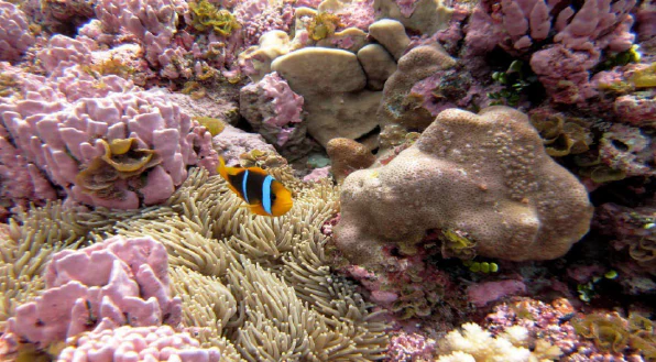
Clownfish swimming among coral formations in an underwater scene
Clownfish swimming among coral reefs at Rose Atoll National Wildlife Refuge

Rose Atoll National Wildlife Refuge history and protected-area timeline

Rose Atoll's history reflects the broader narrative of Pacific exploration and American territorial expansion. The first Western sighting occurred on June 13, 1722, when Dutch explorer Jacob Roggeveen encountered the atoll and dismissively named it Vuil Eiland, meaning useless island. The more enduring name came in 1819 when French explorer Louis de Freycinet arrived and named the island after his wife Rose de Freycinet, who was herself notable as the second woman to circumnavigate the globe and the first to publish an account of her journey. The atoll was seen again in 1824 by Otto von Kotzebue's expedition, which named it Kordinkov after the explorer's first lieutenant. In more recent history, Rose Atoll gained unexpected prominence when Apollo 10 returned to Earth near the atoll on May 26, 1969, with astronauts being warmly welcomed at Pago Pago International Airport before transport to Hawaii. The formal protection of Rose Atoll began in 1973 when it was established as a National Wildlife Refuge, covering approximately 39,000 acres. This was significantly expanded in 2009 with the creation of the Rose Atoll Marine National Monument, which extended protection to the surrounding marine waters.

Rose Atoll National Wildlife Refuge landscape and geographic character

Rose Atoll presents a classic atoll landscape defined by its ring-shaped reef surrounding a central lagoon. The atoll measures approximately 2.6 kilometers by 2.7 kilometers, making it nearly square and among the smallest atolls globally. Two islets occupy the northeastern rim of the reef: Rose Island, which reaches about 3.5 meters above sea level and supports vegetation including the only remaining Pisonia forest in all of Samoa, and the smaller, non-vegetated Sand Island rising just 1.5 meters high. A narrow channel approximately 80 meters wide provides access to the lagoon from the west. The reef flat and lagoon together cover about 6.33 square kilometers, while the broader marine environment protected by the monument extends to over 8.5 million acres. The surrounding ocean waters feature diverse coral formations, with the rose-colored corals that give the atoll its name being particularly notable. The isolation of Rose Atoll is pronounced, with the nearest island, Ta'ū, located 140 kilometers to the west-northwest.
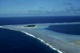
Aerial view of Rose Atoll National Wildlife Refuge featuring a small central island surrounded by a lagoon and ocean
Aerial view of Rose Atoll National Wildlife Refuge showing the central island and surrounding lagoon

Rose Atoll National Wildlife Refuge ecosystems, habitats, and plant life

The ecological character of Rose Atoll is defined by the remarkable biodiversity concentrated in its relatively small footprint. The marine environment hosts the largest populations of giant clams and rare reef fish found anywhere in American Samoa, with nearly 270 fish species recorded in the past fifteen years. The fish community exhibits a distinctive structure with an unusually high concentration of carnivorous fish and notably low numbers of herbivorous fish, creating an atypical reef ecosystem. The surrounding waters support tuna, mahi-mahi, billfish, barracuda, and sharks in the open waters beyond the lagoon, while deeper waters have revealed tunicates and stalked crinoids observed by scuba expeditions. Rose Atoll's terrestrial nature is characterized by the Pisonia forest, which represents the only remaining example of this forest type in all of Samoa. The pink coralline algae that carpets the reef adds another distinctive element to the atoll's natural character.

Rose Atoll National Wildlife Refuge wildlife and species highlights

Rose Atoll supports extraordinary wildlife populations that justify its designation as a critical conservation area. The atoll serves as the primary nesting habitat for threatened green turtles and endangered hawksbill turtles, which migrate between American Samoa and other Pacific island nations during the nesting season from August through February. The bird populations are particularly remarkable, with approximately 97 percent of American Samoa's entire seabird population concentrated on the atoll. Twelve federally protected bird species nest here, including red-footed boobies, greater and lesser frigate birds, black noddies, white terns, Pacific reef herons, and red-tailed tropic birds. The Pisonia forest provides crucial nesting habitat for these species, while the surrounding waters support sea mammals including endangered humpback whales and dolphins of the genus Stenella. The fish diversity is exceptional, with the unusual abundance of rose-colored corals providing habitat for nearly 270 recorded fish species.

Rose Atoll National Wildlife Refuge conservation status and protection priorities

Rose Atoll's conservation significance is reflected in its multiple protected area designations and the international recognition it has received. The site was originally protected as a National Wildlife Refuge in 1973, with the marine environment later receiving enhanced protection through the 2009 establishment of the Rose Atoll Marine National Monument. This designation was specifically cited for the presence of rare species including giant clams and reef sharks, as well as the unusual abundance of rose-colored corals. BirdLife International has recognized the atoll as an Important Bird Area due to its support of approximately 400,000 breeding sooty terns. The cooperative management arrangement between the U.S. Fish and Wildlife Service, American Samoa, and NOAA's Office of National Marine Sanctuaries demonstrates the multi-jurisdictional approach needed to effectively protect both the terrestrial and marine components of this ecosystem. The integration of the monument's marine areas into the National Marine Sanctuary of American Samoa in 2014 further strengthened the conservation framework.

Rose Atoll National Wildlife Refuge cultural meaning and human context

Rose Atoll holds cultural significance for the people of the Manu'a Islands, who have traditionally referred to the atoll as Motu O Manu, meaning Bird Island. This name reflects the overwhelming presence of seabirds that nest on the atoll and represents the historical connection between local communities and this remote natural landmark. While the atoll itself is uninhabited today, the Manu'a Islands lying to the west maintain cultural and historical ties to this easternmost point of American Samoa. The establishment of the Rose Atoll Marine National Monument in 2009 reflected a partnership between the federal government and the territory of American Samoa, acknowledging both the ecological importance of the site and its regional significance within Samoan cultural context.

Top sights and standout views in Rose Atoll National Wildlife Refuge

Rose Atoll National Wildlife Refuge represents the convergence of several extraordinary conservation values within a single, compact geographic unit. The atoll is distinguished by its status as the southernmost point of the United States and the only atoll in the Samoan Islands chain. Its marine waters contain exceptional biodiversity including the largest giant clam populations in American Samoa and nearly 270 fish species. The site supports approximately 400,000 nesting seabirds, representing 97 percent of the territory's bird population. The presence of rose-colored corals is unusual in the Pacific and gives the atoll its distinctive character. Both green turtles and endangered hawksbill turtles rely on Rose Atoll for nesting, while the surrounding waters provide habitat for endangered humpback whales.

Best time to visit Rose Atoll National Wildlife Refuge

Rose Atoll's remote location and protected status mean that visitor access is limited and carefully managed. The turtle nesting season from August through February represents the period when the atoll's terrestrial wildlife is most active, with green and hawksbill turtles coming ashore to nest. This period also coincides with the seabird breeding season, offering opportunities to observe the extraordinary bird populations that concentrate on the atoll. However, as a National Wildlife Refuge and Marine National Monument, access requires careful coordination with the U.S. Fish and Wildlife Service, and the focus remains on protection rather than tourism.

Monthly climate preview

Long-term average temperature and monthly precipitation rhythm for American Samoa

Rose Atoll National Wildlife Refuge Climate Normals and Annual Weather Patterns

Representative coordinate records show sustained warm monthly temperatures alongside a distinct annual precipitation cycle across Rose Atoll National Wildlife Refuge. Exploring the complete monthly climate normals reveals deeper variations in temperature ranges and rainfall distribution.
Annual mean28 °C
27 °C28 °C
Jan28°
Feb28°
Mar28°
Apr28°
May28°
Jun27°
Jul27°
Aug27°
Sep27°
Oct27°
Nov28°
Dec28°
Warmest month
April

28.1 °C

Coolest month
August

26.7 °C

Wettest month
January

8.8 mm/day

Driest month
August

1.8 mm/day

Park location guide

Geography guide, regional context, and park location map for Rose Atoll National Wildlife Refuge

Rose Atoll National Wildlife Refuge park geography, regions, and map view in United States of America

Understand where Rose Atoll National Wildlife Refuge sits in United States of America through a broader geographic reading of the surrounding landscape, nearby location context, and its mapped position within the national park landscape.

How Rose Atoll National Wildlife Refuge fits into United States of America

The United States of America is a federal presidential republic and one of the world's largest countries by area and population. It consists of 50 states across a vast territory spanning multiple time zones, with its capital in Washington, D.C. and largest city in New York City. The nation has a diverse economy, influential political system, and significant cultural and military presence globally.

Wider geography shaping Rose Atoll National Wildlife Refuge in United States of America

The United States occupies a vast territory in North America, bordered by Canada to the north and Mexico to the south. The 48 contiguous states stretch from the Atlantic to the Pacific Ocean, while Alaska occupies the northwestern region and Hawaii is an archipelago in the Pacific. The country encompasses diverse terrain including the Rocky Mountains, Appalachian Mountains, Great Plains, and extensive river systems.

Map view of Rose Atoll National Wildlife Refuge

Use this park location map to pinpoint Rose Atoll National Wildlife Refuge in United States of America, understand its exact geographic position, and read its mapped placement within the surrounding landscape more clearly.

Pigeon | © OpenStreetMap contributors

Location context for Rose Atoll National Wildlife Refuge

American Samoa

Visual Atlas of Rose Atoll's Protected Marine Scenery, Coral Reef Ecosystems, and Remote Island Geography

Rose Atoll National Wildlife Refuge Photos: Explore Pacific Marine Landscapes and Seabird Habitats

Discover immersive photography capturing the distinctive marine and terrestrial environments of Rose Atoll National Wildlife Refuge, a critical Pacific protected area. These images offer an essential visual reference to understand the atoll's unique rose-colored corals, abundant seabird nesting sites, and the pristine, remote character of its reef and lagoon ecosystems.

Clownfish swimming among coral formations in an underwater scene

Two boats in turquoise ocean water with people conducting scientific research activities

Aerial view of Rose Atoll National Wildlife Refuge featuring a small central island surrounded by a lagoon and ocean

Park atlas

Compare the unique marine ecosystems and remote island conservation efforts across the Pacific

Find Related Protected Areas and Marine Parks Beyond Rose Atoll National Wildlife Refuge

Browse an atlas of protected marine areas and remote Pacific atolls, tracing their geographic spread and unique conservation landscapes. Comparing these significant protected areas reveals interconnected marine biodiversity, unique atoll ecosystems, and broader conservation strategies across the Pacific.
Marine protected areaAmerican Samoa
Mapped location lies within the park boundary#1 closest

South

Rose Atoll Marine National Monument: Protected Marine Area in American Samoa

Explore mapped boundaries and regional geographic context.

Rose Atoll Marine National Monument is designated as a marine protected area within the geographic scope of American Samoa. This page offers detailed insights into its protected status, mapped terrain, and the surrounding natural landscapes. It serves as a resource for understanding the park's specific boundaries and its role as a conservation area, providing a foundation for geographic discovery.

Relief
Lowland
Scope
Marine
Water
Water-dominated
Marine protected areaAmerican Samoa
About 1 km away#2 closest

West

National Marine Sanctuary of American Samoa: Mapped Marine Protected Area Geography

Discover protected marine landscapes across American Samoa's region.

Investigate the National Marine Sanctuary of American Samoa, a protected marine area with distinct geographic relevance. This detailed view focuses on its mapped boundaries and its role as a protected landscape within the broader atlas of American Samoa. Understand the unique environmental context and protected-area significance that shapes this marine sanctuary.

Area
35,170 km²
Established
1986
Climate
Tropical
Access
Easy access
National parkUnited States of America
About 140 km away#3 closest

West

National Park of American Samoa: A Mapped Protected Landscape within the USA

Discover its island geography and protected area context.

National Park of American Samoa stands as a significant protected natural area, offering unique insights into island geography and conservation landscapes. Explore its detailed mapped boundaries and understand its placement within the broader atlas of United States of America protected lands. This entity provides a focal point for understanding distinct geographic features and the territorial spread of protected natural resources.

Area
33.414 km²
Established
1988
IUCN
V
Visitors
12.1K annual
National parkSamoa
About 388 km away#4 closest

West

O Le Pupu-Puʿe National Park: Explore Samoa's Protected National Park Geography and Boundaries

Mapped terrain and protected landscape context for this Samoan national park.

Understand O Le Pupu-Puʿe National Park as a significant protected area within Samoa's archipelago. This detail entry provides essential geographic context, mapping its boundaries and situating it within the nation's protected lands. Explore the park's role as a national park and its contribution to the mapped natural landscape of Samoa.

Area
50.2 km²
Established
1978
IUCN
II
Relief
Mixed relief
National parkUpolu
About 404 km away#5 closest

West

Lake Lanoto'o National Park: Discover Its Protected Landscape and Geographic Setting on Upolu

Explore park boundaries and regional natural terrain.

Lake Lanoto'o National Park represents a crucial protected area on the island of Upolu, Samoa. This page provides detailed geographic information, focusing on the park's mapped boundaries and its contribution to the natural landscape of the region. Understand its role as a national park and its position within the broader atlas of protected lands, offering insight into the island's unique geography.

Area
4.7 km²
Established
2003
IUCN
II
Relief
Highland
National parkTonga
About 1,043 km away#6 closest

Southwest

'Eua National Park: Tonga Protected Landscape and Geographic Context

Explore mapped boundaries and unique natural terrain within Tonga.

Access detailed geographic information and mapped boundaries for 'Eua National Park, Tonga's designated national park. This resource provides an atlas-style overview of the park's protected landscape identity, focusing on its natural terrain and its specific place within the broader geography of the Kingdom of Tonga. Understand the park's conservation significance through its landscape context and mapped distribution.

Nature reserveNew Zealand
About 1,916 km away#7 closest

Southwest

Kermadec Islands Nature Reserve: Mapping the Volcanic Terrain and Subtropical Ecosystems

A remote New Zealand volcanic arc and marine protected area.

The Kermadec Islands comprise an isolated chain of volcanic landforms stretching along a submarine ridge in the South Pacific. This nature reserve protects unique subtropical moist forests, diverse seabird colonies, and complex hydrothermal vent communities, serving as a critical area for ongoing ecological restoration and marine science.

Area
33.6 km²
Established
1937
Relief
Mountain
Climate
Subtropical
Marine protected areaNorfolk Island
About 2,694 km away#8 closest

Southwest

Norfolk Marine Park: A Comprehensive Look at Australia's Offshore Protected Ocean Reserve

Marine geography, deep sea features, and ocean convergence zones

Norfolk Marine Park represents a vast expanse of offshore territory defined by varied seafloor bathymetry including ridges, plateaus, and troughs. As a key component of the Temperate East Marine Parks Network, the reserve protects the Tasman Front, where dynamic water masses interact to drive biological productivity across the South Pacific. Its geographic isolation and structural diversity make it a pivotal research site for understanding regional marine ecosystems and deep-water fauna connectivity.

Area
188,444 km²
Established
2018
IUCN
IV
Climate
Subtropical

Common questions about visiting, size, designation, and location context for Rose Atoll National Wildlife Refuge

Rose Atoll National Wildlife Refuge FAQs for park facts, access, geography, and protected area context

Find quick answers about Rose Atoll National Wildlife Refuge, including protected-area facts, park geography, trail and visitor context, and how the park fits into its surrounding country and regional landscape.
MoriAtlas Explorer

Continue Your Protected Areas Search Across the Global Atlas

Deepen your exploration by continuing the structured search for national parks and protected areas worldwide. Utilize the comprehensive filtering capabilities to compare different conservation landscapes and refine your understanding of global park geography. Discover more about the distribution and characteristics of protected natural areas.

Global natural geography