
Mori Atlas logo
Natural monumentRotava

A study of volcanic landforms and rare botanical communities in the Krušné hory foothills

Rotava Natural Monument: Exploring Geological Basalt Formations in the Karlovarský kraj Region

(Rotavské varhany)

Rotava Natural Monument protects a significant geological outcrop of columnar basalt, often described as organ pipes, situated within the Karlovarský kraj region. This protected area serves as an essential site for observing volcanic landforms and mineral-rich botanical habitats that define the foothills of the Krušné hory mountain range. The site offers deep insight into local geological history through its exposed vertical prisms and unique rock geometry.

geological monumentcolumnar basaltvolcanic landformKrušné hory foothillsKarlovarský Regionrocky habitats
An illustration showing a large, purple columnar basalt rock formation set against a green forest and sky with a sun.

Rotava

Natural monument

Park overview

Structured park overview, official facts, and landscape profile for Rotava Natural Monument

Rotava Natural Monument park facts, protected area profile, and essential visitor context

Review the core facts for Rotava Natural Monument, including designation, size, terrain, visitor scale, habitats, and operating context in one park-focused overview.

About Rotava Natural Monument

Rotava Natural Monument lies in the northwestern part of the Czech Republic, in the Sokolov District of the Karlovarský Region, near the town of Rotava. Although it is one of the smaller formally protected sites in the country, it enjoys a focused identity because it preserves an unusually well-defined example of columnar basalt weathering, a phenomenon more famously associated with sites such as the Giant's Causeway in Northern Ireland or the Devils Postpile in California. In Czech, the feature is known as rotavské varhany, meaning Rotava organ pipes, a name that captures the visual similarity between the parallel basalt columns and the ranks of pipes in a musical pipe organ.

The protected area was established on 11 July 1978 and covers roughly 0.33 hectares (about 3,300 square meters). It is administered by the Karlovarský Regional Authority and is classified under the Czech system as a přírodní památka, or natural monument, equivalent locally to a small-scale geological and habitat protection designation. At the international level, the site is assigned to IUCN Category IV, which signifies a protected area managed mainly for the conservation of specific habitats or species rather than as a broad ecosystem reserve. The site sits at an elevation of about 643 meters above sea level.

Beyond its formal role as a nature reserve, Rotava Natural Monument reflects the longer industrial and geological history of the Krušné hory region. The volcanic body from which the basalt columns formed is connected to the broader geological story of the Karlovy Vary Pluton and the uplifted crystalline basement of the Ore Mountains. Many of the rocks now visible at the surface were exposed historically by quarrying activity that cut into the hillsides. While that quarrying originally served practical purposes, including the extraction of basalt columns for use as road gravel, it incidentally uncovered the regular columnar structure that makes the site scientifically interesting today.

Quick facts and research context for Rotava Natural Monument

Rotava Natural Monument is a Czech protected area in the Karlovarský Region, located just east of the town of Rotava in the Sokolov District. It was designated as a přírodní památka (natural monument) on 11 July 1978 and is registered under code 373 in the central nature conservation database.

The site is classified as an IUCN Category IV protected area, reflecting its purpose as a small-scale habitat and geological conservation site. Its total area is roughly 0.33 hectares, and it lies at an elevation of 643 meters above sea level.

The protected feature is a columnar basalt outcrop known locally as Rotavské varhany, formed where alkaline basaltic magma intruded along the contact between the Karlovy Vary Pluton granite and the crystalline basement of the Krušné hory. The site also harbors several rare plant species, including Woodsia ilvensis and Arnica montana.

Protection and recognition

Terrestrial protected area framework and international recognition details

Rotava Protection Status and Documented Conservation Scope

Rotava maintains a documented terrestrial protection scope within its designated natural monument boundaries. Structured conservation records outline the official management framework and recognized geographical status.

Protection details

Protection scope
Terrestrial
Park context

Deeper park guide and search-rich context for Rotava Natural Monument

Rotava Natural Monument history, landscape, wildlife, and travel context

Explore Rotava Natural Monument through its history, landscape character, ecosystems, wildlife, conservation priorities, cultural context, and seasonal travel timing in a structured park guide built for atlas discovery and search intent.

Why Rotava Natural Monument stands out

Rotava Natural Monument is best known for its columnar basalt formation known in Czech as rotavské varhany, or Rotava organ pipes. The basalt columns rise up to about twelve meters high and are stacked in parallel, pipe-like rows that give the exposition the appearance of a giant wooden organ. The feature is a classic example of columnar jointing in volcanic rock. It is also notable as one of the better-preserved geological curiosities in the western Krušné hory foothills, where most of the region's volcanic structures have been heavily altered by mining or weathering. Beyond the geology, the site supports a small community of rare ferns and plants, giving it a botanical interest that complements its mineralogical character.
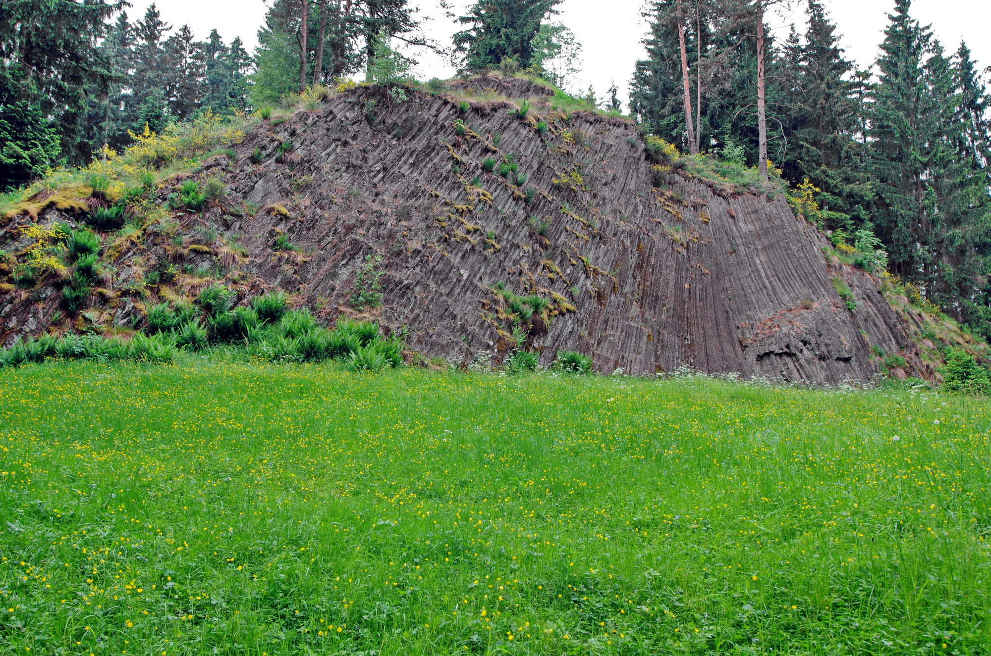
A green meadow leading to a steep slope of exposed dark, vertical columnar basalt rock formations surrounded by coniferous trees.
The basalt rock formation known as the Rotava organ pipes in the Czech Republic.

Rotava Natural Monument history and protected-area timeline

The natural monument at Rotava was formally declared in 1978, registered as Czech protected area code 373. Its establishment was driven primarily by the need to safeguard the columnar basalt outcrop after intensive quarrying in earlier decades had altered and partly exposed the volcanic body.

The surrounding landscape has a long history of industrial extraction. Quarrying activity at the site not only removed many basalt columns for use as road aggregate but also exposed the inner structure of the volcanic hill, revealing the arrangement of columnar joints that defines rotavské varhany today. As a result, the present appearance of the monument is shaped as much by past human intervention as by natural geological processes.

Rotava Natural Monument landscape and geographic character

The landscape of Rotava Natural Monument centers on a single small volcanic hill whose flanks expose sharp, regularly arranged basalt columns. These columns are vertical to near-vertical polygonal prisms that resemble the ranks of pipes in an organ, which is the origin of the local name rotavské varhany. The tallest columns reach heights of roughly twelve meters, and the geometry of the columns differs slightly between the eastern and western sectors of the site, suggesting two separate intrusions.

The setting lies in the foothills of the Krušné hory (Ore Mountains), at the contact between the granite of the Karlovy Vary Pluton and the older crystalline basement rocks of the mountain range. The terrain around the monument is hilly, with rocky slopes, scree, and small clearings. Steep exposed rock surfaces alternate with patches of soil in which the characteristic flora of acidic, mineral-rich substrates can take hold. From a wider perspective, the immediate hills are part of a landscape heavily modified by historical mining and quarrying, so the monument today reads as a geological island within a broader pattern of industrial land use.

Rotava Natural Monument ecosystems, habitats, and plant life

Ecologically, the Rotava Natural Monument is a small but botanically rich site, defined by the unusual combination of exposed basalt rock, scree slopes, and small patches of acidic substrate. The conditions create a mosaic of microhabitats, including bare rock walls, lichen-covered boulders, and isolated pockets of soil that support distinct plant communities.

On the rock faces themselves, fern species such as Asplenium septentrionale and Asplenium trichomanes colonize cracks and ledges, while a small colony of the rare Woodsia ilvensis grows in isolated patches in the western part of the monument. These fern-rich habitats are among the most ecologically notable features of the site. On the summit and along parts of the scree, vegetation shifts toward a mix of woodland and dry grassland, where species adapted to acidic, nutrient-poor substrates dominate.

Rotava Natural Monument wildlife and species highlights

Although the monument is very small, it provides habitat for a modest but ecologically meaningful fauna. The most notable protected animal recorded here is the common European adder, Vipera berus, which finds shelter among the basalt boulders and scree.

Because of the limited size of the protected area and its predominantly rocky, exposed character, the site is best understood as a specialist microhabitat rather than a wildlife area in the conventional sense. Nevertheless, the combination of rock crevices, patches of woodland vegetation, and open meadow clearings supports a small but balanced community of invertebrates, reptiles, and typical woodland species of the Krušné hory foothills.

Rotava Natural Monument conservation status and protection priorities

Rotava Natural Monument is formally protected as a přírodní památka, a national-level designation in the Czech Republic aimed at conserving small but scientifically significant natural features. At the international level, it is classified as IUCN Category IV, indicating its role as a habitat and species management area rather than a broad ecosystem reserve.

Its conservation value lies principally in preserving an accessible, well-exposed example of columnar basalt weathering along the structural contact between the Karlovy Vary Pluton and the crystalline complex of the Krušné hory. The site also carries botanical conservation significance because it shelters small populations of rare and declining plant species, including Woodsia ilvensis, Teucrium scorodonia, and Arnica montana.

Limiting further quarrying and managing recreational pressure are central to maintaining both the geological exposure and the fragile plant communities. Because the protected area is very small, even minor disturbance can disproportionately affect its core features, which is why the monument is administered at the regional level with attention to both geological and ecological integrity.

Rotava Natural Monument cultural meaning and human context

The monument reflects the deep intertwining of natural heritage and industrial history that characterizes the Krušné hory foothills. The quarrying that exposed the basalt columns was historically part of the regional mining economy that shaped settlements like Rotava and the wider Sokolov basin.

The local name rotavské varhany, the Rotava organ pipes, ties the site closely to the identity of the town of Rotava and gives the geological curiosity a lasting cultural resonance. The feature is often referenced in regional guides to the Karlovarský Region as a natural landmark that complements the area's better-known spa and mining heritage, offering visitors a glimpse of the volcanic and tectonic forces that shaped the Ore Mountains long before any human settlement existed.

Top sights and standout views in Rotava Natural Monument

The standout feature of Rotava Natural Monument is its rotavské varhany, a tightly packed array of vertical basalt columns forming a natural organ-pipe facade. Beyond this geological centerpiece, the site is distinguished by the rare fern Woodsia ilvensis, by populations of Arnica montana on the dry grassy summit, and by an unusually clean exposure of basaltic rock that makes the columnar jointing visible across both the western and eastern parts of the outcrop.

On a broader level, the monument captures the geological story of the contact between the Karlovy Vary Pluton and the crystalline basement of the Krušné hory. The combination of columnar jointing, post-quarrying exposure, and a small but botanically diverse flora makes the site one of the more distinctive, if compact, protected natural landmarks in northern Bohemia.

Best time to visit Rotava Natural Monument

Late spring and early summer are typically the most rewarding months to visit, when the dry meadow species on the summit and upper slopes, including Dianthus deltoides, Hypericum maculatum, and various Potentilla species, come into flower, and the ferns in the rocky zones are visibly active. Summer offers the most comfortable weather for walking the short trails around the site, while the exposed basalt columns remain atmospherically dramatic even in bright midday light.

Autumn brings quieter conditions and warmer leaf tones in the surrounding deciduous growth, while winter can also be appealing for visitors interested in the stark architectural quality of the exposed basalt columns. Because the monument is primarily a geological and botanical stop rather than a large-scale outdoor destination, any season can be appropriate, provided the ground is safe to walk over the rocky slopes.

Monthly climate preview

Examining annual temperature ranges and monthly precipitation patterns for Rotava

Rotava Climate Normals and Long-Term Weather by Month

Long-term NASA records reveal measured temperature shifts and precipitation averages across twelve distinct monthly intervals for Rotava. Analyzing these baseline climate normals provides essential context for understanding the protected area through comprehensive monthly profiles.
Annual mean7 °C
-3 °C17 °C
Jan-3°
Feb-2°
Mar
Apr
May12°
Jun15°
Jul17°
Aug17°
Sep13°
Oct
Nov
Dec-1°
Warmest month
July

17.5 °C

Coolest month
January

-2.5 °C

Wettest month
July

2.8 mm/day

Driest month
April

1.4 mm/day

Park location guide

Geography guide, regional context, and park location map for Rotava Natural Monument

Rotava Natural Monument park geography, regions, and map view in Czechia

Understand where Rotava Natural Monument sits in Czechia through a broader geographic reading of the surrounding landscape, nearby location context, and its mapped position within the national park landscape.

How Rotava Natural Monument fits into Czechia

Czech Republic is a landlocked Central European country with a population of approximately 10.9 million people. The nation was established as an independent state on January 1, 1993, following the dissolution of Czechoslovakia. Its capital and largest city is Prague, with other major urban centers including Brno, Ostrava, Plzeň, and Liberec.

Wider geography shaping Rotava Natural Monument in Czechia

The Czech Republic is a landlocked country in Central Europe. It is bordered by Germany to the west, Austria to the south, Poland to the northeast, and Slovakia to the southeast. The landscape is predominantly hilly, with the territory covering 78,871 square kilometers.

Map view of Rotava Natural Monument

Use this park location map to pinpoint Rotava Natural Monument in Czechia, understand its exact geographic position, and read its mapped placement within the surrounding landscape more clearly.

Pigeon | © OpenStreetMap contributors

Location context for Rotava Natural Monument

Karlovarský kraj

Examine the striking terrain, columnar basalt structures, and rocky habitats of Rotava.

Rotava Photos and Protected Landscapes: Visual Exploration of Basalt Formations

Visual documentation captures the steep rocky slopes, volcanic outcrops, and specialized botanical communities that define the protected environment. Detailed photographic records provide clear insight into the geological architecture and unique landforms preserved within the regional foothills.

A green meadow leading to a steep slope of exposed dark, vertical columnar basalt rock formations surrounded by coniferous trees.

Park atlas

Compare regional geology and surrounding protected areas in the Krušné hory foothills

Explore Other Parks Near Rotava and Connected Protected Landscapes

Continue browsing other parks near Rotava to discover related volcanic landforms and protected terrain across the surrounding region. Comparing adjacent natural monuments provides deeper geographic context for the mineralogy and botanical habitats of the mountain foothills.
A horizontal watercolor illustration depicting a soft, green, mountain landscape with hills, conifers, and a waterlogged meadow.
Natural monumentKarlovy Vary Region
About 9.9 km away#1 closest

Northeast

Rudenská luční prameniště Natural Monument: Protected Mountain Wetland Atlas

Karlovy Vary Region Ore Mountains landscape mapping

Rudenská luční prameniště is a protected mountain wetland in the Ore Mountains, defined by a distinct mosaic of spring fens, peat deposits, and mountain meadows. Its geographic layout, spanning twenty three hectares across sloping terrain, creates a vital drainage system for the local landscape. By examining this protected site, you can better understand the unique hydrological and botanical features that distinguish these rare mountain mire complexes from the surrounding highland forests.

Area
0.232 km²
Established
2020
IUCN
IV
Relief
Mountain
Watercolor painting of a flat marshy landscape with a small winding stream in the foreground, green trees in the midground, and soft purple mountain silhouettes in the distance.
Nature reserveSaxony
About 13 km away#2 closest

North

Großer Kranichsee Nature Reserve: Protected Raised Bog Geography and Ore Mountain Landscapes

Watershed moorland, mountain pine forests, and Saxony high plateau geography.

Großer Kranichsee serves as a primary example of an intact raised bog system in the Ore Mountains. The reserve features rare peat-forming vegetation and highland bog forests, occupying a high-altitude plateau that bridges the border between Saxony and the Czech Republic. Its geographic significance stems from its role as a triple watershed, defining the drainage patterns for three distinct regional river systems within the protected Erzgebirgskamm zone.

Area
6.11 km²
Established
1912
A horizontal watercolor painting showing rolling green hills and distant mountain ridgelines behind a foreground of grassy meadows and trees.
Nature reserveSaxony
About 14 km away#3 closest

North

Dreibächel Nature Reserve: Mapping the Old-Growth Spruce Stands of the Western Ore Mountains

A historic protected landscape and mountain watershed in Saxony, Germany

Dreibächel serves as a living archive of traditional forest management, holding the distinction of containing the oldest spruce trees in Saxony. Located on the slopes of the Schneehübel, the reserve is characterized by a dense, multi-layered mountain forest canopy and the confluence of three vital streams. The area remains a essential site for observing historical plenterwald ecology and the natural hydrology of the Westerzgebirge region.

Area
0.147 km²
Established
1961
IUCN
IV
Natural monumentKarlovarský kraj
About 18 km away#4 closest

Northeast

Vlčí jámy Natural Monument: Protected Geological and Industrial Heritage in Bohemia

Ore Mountains mining collapse and relict microclimate landscape

Vlčí jámy protects a rare intersection of medieval mining history and environmental significance in the Karlovarský kraj. The site is defined by two deep collapse features, Ledová jáma and Vlčí jáma, which function as persistent cold traps. These geological anomalies support critically endangered mosses and bat colonies, illustrating how abandoned industrial landscapes in the Ore Mountains evolve into essential, small-scale protected habitats.

Area
0.014 km²
Established
1975
IUCN
III
Relief
Mountain
A horizontal watercolor illustration of a gentle landscape with scattered trees, soft green foliage, and faint mountain outlines in the background.
Nature reserveSaxony
About 18 km away#5 closest

North

Am Riedert Nature Reserve: Protected Mountain Forest Geography in Saxony, Germany

Analyzing the ecological boundaries and Hercynian mountain mixed forest terrain

Am Riedert is a compact but ecologically important nature reserve situated on the rugged slopes of the western Erzgebirge. This site protects a significant example of mountain mixed forest, characterized by its mature silver fir populations and active natural regeneration. By examining its location south of the Zwickauer Mulde river, visitors can trace the intersection of Saxon history and conservation within this unique protected landscape.

Area
0.185 km²
Established
1961
IUCN
IV
Relief
Mountain
Nature reserveSachsen
About 20 km away#6 closest

North

Friedrichsheider Hochmoor Nature Reserve: Geography and Protected Bog Landscape in Sachsen

High-elevation peatland and bog pine forest mapping

Situated at 800 meters above sea level near Sosa, Friedrichsheider Hochmoor serves as a cornerstone of peatland conservation in the Erzgebirge. This reserve is defined by its thick peat body and dense Spirken moor forest, offering a rare look at near-intact mire ecosystems that support diverse Sphagnum mosses and subarctic plant communities within a protected regional framework.

Area
0.19 km²
Established
1967
IUCN
IV
A stylized vector-style illustration showing a man and a child standing on the grassy bank of a pond, watching a swimmer in the middle of the water, with a waterfall and forest in the background.
Natural monumentKarlovarský kraj
About 24 km away#7 closest

Southeast

Na Vážkách Natural Monument: Mapping Protected Forest Landscapes in Karlovarský kraj

A rare oligotrophic pond and wetland habitat in Western Bohemia.

Na Vážkách provides a unique example of small-scale landscape protection, featuring clear, sandy-bottomed waters within the broader forest mosaic of Karlovarský kraj. Designated in 2017, this natural monument is recognized for its significant dragonfly populations and its role in preserving historical aquatic water systems.

Area
0.026 km²
Established
2017
IUCN
III
Relief
Upland
Natural monumentKarlovarský kraj
About 25 km away#8 closest

West

Vernéřovské doly Natural Monument: A Geological Landmark in the Karlovarský kraj

Rare pegmatite mineralogy and historic mining terrain in western Czechia.

Located in the Cheb District, Vernéřovské doly functions as a specialized natural monument dedicated to preserving a quartz-amblygonite-microcline vein system. This protected area provides a window into hydrothermal ore formation, featuring geological structures comparable only to sites in Portugal and the Ural Mountains.

Area
0.003 km²
Established
1999
IUCN
III
Relief
Upland

Common questions about visiting, size, designation, and location context for Rotava Natural Monument

Rotava Natural Monument FAQs for park facts, access, geography, and protected area context

Find quick answers about Rotava Natural Monument, including protected-area facts, park geography, trail and visitor context, and how the park fits into its surrounding country and regional landscape.
MoriAtlas Explorer

Continue Your Protected Areas Search Across the Global Atlas

Deepen your exploration by continuing the structured search for national parks and protected areas worldwide. Utilize the comprehensive filtering capabilities to compare different conservation landscapes and refine your understanding of global park geography. Discover more about the distribution and characteristics of protected natural areas.

Global natural geography