
Mori Atlas logo
Nature reserveRotes Wasser von Olfen

A rare mosaic of transitional mire and iron-rich wetland habitats in the Hessian low mountain range.

Rotes Wasser von Olfen Nature Reserve: Mapping Protected Bog Landscapes in the Odenwald Hills

(Naturschutzgebiet Rotes Wasser von Olfen)

Located in the Odenwald hills of Hessen, Rotes Wasser von Olfen serves as a critical protected area for surviving lowland bog vegetation in a central German low mountain landscape. This site spans the upper valley of the Hinterbach, where distinctive iron-rich groundwater supports a unique botanical community featuring sphagnum mosses, cottongrass, and the round-leaved sundew. Its compact terrain offers a rare glimpse into how transitional mires and wet meadows interact with surrounding forested ridges.

bogmoorlandwetlandnature reserveOdenwaldiron-rich stream
A flat vector illustration of a calm river winding through a forest landscape with green and pink trees, grassy banks, and a cloudy sky with a sun.

Rotes Wasser von Olfen

Nature reserve

Park overview

Structured park overview, official facts, and landscape profile for Rotes Wasser von Olfen

Rotes Wasser von Olfen park facts, protected area profile, and essential visitor context

Review the core facts for Rotes Wasser von Olfen, including designation, size, terrain, visitor scale, habitats, and operating context in one park-focused overview.

About Rotes Wasser von Olfen

Rotes Wasser von Olfen is a compact but ecologically precious nature reserve tucked into the wooded ridges of the Odenwald in southern Hesse. Although it covers only about twelve hectares, it has an outsized conservation importance because it preserves one of the very last remnants of a bog habitat type that once occurred more widely in the low mountain ranges of central Germany. The protected valley lies in the headwaters of the Hinterbach stream, a tributary eventually flowing toward the Finkenbach, and its floor has become waterlogged and peat-forming over centuries of iron-rich seepage from the surrounding hillslopes.

The reserve sits across the boundary of two districts, the Odenwaldkreis and the Landkreis Bergstraße, spanning parts of the communes Oberzent, Mossautal, and Wald-Michelbach. Its landscape is shaped by the contrast between the soft, waterlogged valley floor and the steeply rising forested slopes of the surrounding Odenwald ridges, including a spur of the Spessartskopf. The wider FFH area, designated in 2008, extends protection to the adjacent agricultural meadows along the L 3120 road, ensuring that the hydrology and habitat mosaic of the bog remain connected to traditionally used open land.

Visitors approaching the reserve pass through the small village of Olfen, near which a late-Gothic sandstone wayside shrine known as the Olfener Bild stands at a road junction on the district road K 47, providing a small cultural landmark just outside the protected zone. From there, narrow forest paths lead into the seepage zone, where the surface water takes on a striking reddish tone from dissolved iron, and small natural pools gather in the boggy ground. The area is not a tourist attraction in the conventional sense but rather a quiet destination for naturalists interested in mire ecology, rare plants, and dragonfly-rich stream systems.

Ecologically, Rotes Wasser von Olfen belongs to the small but important network of protected sites in the Odenwald that has been identified through systematic biotope mapping as irreplaceable for conserving bog habitats in Hesse. Its combination of protected status, active management, and inclusion in the European Habitats Directive network gives it both national and international recognition as a refuge for species that would otherwise disappear from the region.

Quick facts and research context for Rotes Wasser von Olfen

Rotes Wasser von Olfen is a designated nature reserve in the Hessian Odenwald, covering about twelve hectares of boggy stream valley near Olfen in the town of Oberzent. It lies partly in the Odenwald district and partly in the Bergstraße district, spanning the communes of Oberzent, Mossautal, and Wald-Michelbach.

The reserve was established on 22 September 1980 and is catalogued under ID 1437006 in the German protection system, with WDPA reference 82448. Since 2008, the area has also formed the core of a larger FFH (Habitats Directive) site known as Rotes Wasser von Olfen mit angrenzenden Flächen, with the Natura 2000 identifier DE 6319 301. The IUCN protection category is IV, classifying it as a Habitat and Species Management Area focused on active conservation of its specialized wetland communities.

Protection and recognition

Documented terrestrial protection metrics and establishment history

Rotes Wasser von Olfen Protection Status and Designated Area History

Rotes Wasser von Olfen maintains official terrestrial protected area designation established in 1980 under documented conservation records. Structured records present verified protection status and management data without additional international recognition sources.

Protection details

Protection scope
Terrestrial
Designated year
1980
Transboundary protection
No
WDPA ID
82448
Park context

Deeper park guide and search-rich context for Rotes Wasser von Olfen

Rotes Wasser von Olfen history, landscape, wildlife, and travel context

Explore Rotes Wasser von Olfen through its history, landscape character, ecosystems, wildlife, conservation priorities, cultural context, and seasonal travel timing in a structured park guide built for atlas discovery and search intent.

Why Rotes Wasser von Olfen stands out

The reserve is best known for being the only remaining site in the entire Odenwald range where a compact mosaic of lowland and transitional bog vegetation still exists. Its peat-forming valley floor and iron-rich seepages create conditions unusual for the region, supporting sphagnum moss communities, cottongrass, mat-grass swards, and insect-eating plants such as the round-leaved sundew. Equally distinctive is the iron-charged groundwater that gives the stream its reddish hue and the protected area its name. This unusual chemistry, combined with careful conservation management such as damming the stream and selective removal of conifers, has helped maintain open, sunlit bog hollows that are otherwise vanishing from central Germany's low mountain landscapes.
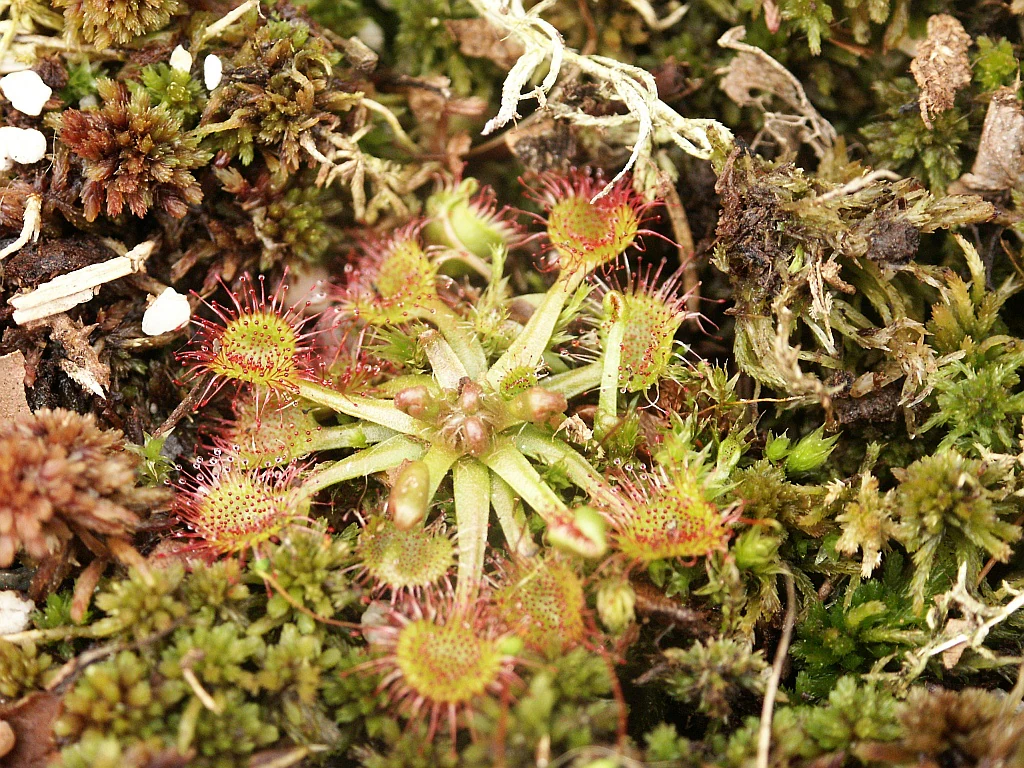
A top-down close-up view of a round-leaved sundew plant with reddish, dew-covered tentacles surrounded by green and brown moss.
Close-up of a round-leaved sundew plant growing among moss in a bog environment.

Rotes Wasser von Olfen history and protected-area timeline

The modern identity of Rotes Wasser von Olfen as a protected area began with formal designation on 22 September 1980, when the Hessian authorities placed roughly twelve hectares of the boggy Hinterbach headwaters under nature reserve status. The protection was a direct response to an official biotope mapping exercise that identified the site as the only place in the entire Odenwald where lowland and transitional mire communities had survived in a small-scale mosaic alongside other wet habitats.

In 2008, the conservation framework was significantly expanded through the formal designation of the adjacent Habitats Directive site, Rotes Wasser von Olfen mit angrenzenden Flächen, under the Natura 2000 network. This enlargement brought the meadows and slopes that were still in agricultural use into the same protection framework, enlarging the effectively managed area to around twenty hectares and reinforcing the importance of the valley's hydrology for the bog itself.

Active conservation management at the site has included continued stream damming to retain water in the peat-forming zones, the targeted felling of conifers to open up ground formerly shaded by dense needle-leaf stands, and grazing in the wooded northern sector to encourage the spread of low heaths. Together, these interventions reflect a shift from purely passive protection toward active habitat stewardship typical of modern European bog conservation in low mountain regions.

Rotes Wasser von Olfen landscape and geographic character

The landscape of Rotes Wasser von Olfen is defined by a narrow, waterlogged headwater valley set within the broader forested ridges of the Odenwald. The protected zone sits in the upper catchment of the Hinterbach, where the stream emerges from seepage zones along the hillslopes rather than from a single clear source. Over centuries, these seepages have built up a soft, peat-forming valley floor dotted with small natural pools and shallow impoundments created by stream dams.

Surrounding the valley, the terrain rises steeply into the wooded ridges typical of the Odenwald, including a long spur running out from the Spessartskopf that ends just to the south of the bog. The contrast between the flat, boggy valley and the steep, forested slopes is one of the defining visual characteristics of the site. Soils in the lower part of the reserve are acidic and peaty, supporting specialist vegetation, while the upper slopes consist mainly of forested mineral soils dominated by mixed deciduous and conifer stands.

The wider FFH area softens this contrast by including a band of traditionally managed hay meadows running through the valley floor toward the L 3120 country road. This mosaic of open meadow, heath, mire, stream, and forest gives the landscape its particular character: not dramatic in scale, but finely textured and ecologically layered, with the unusual reddish water providing an immediate visual signal of the iron-rich geology beneath.
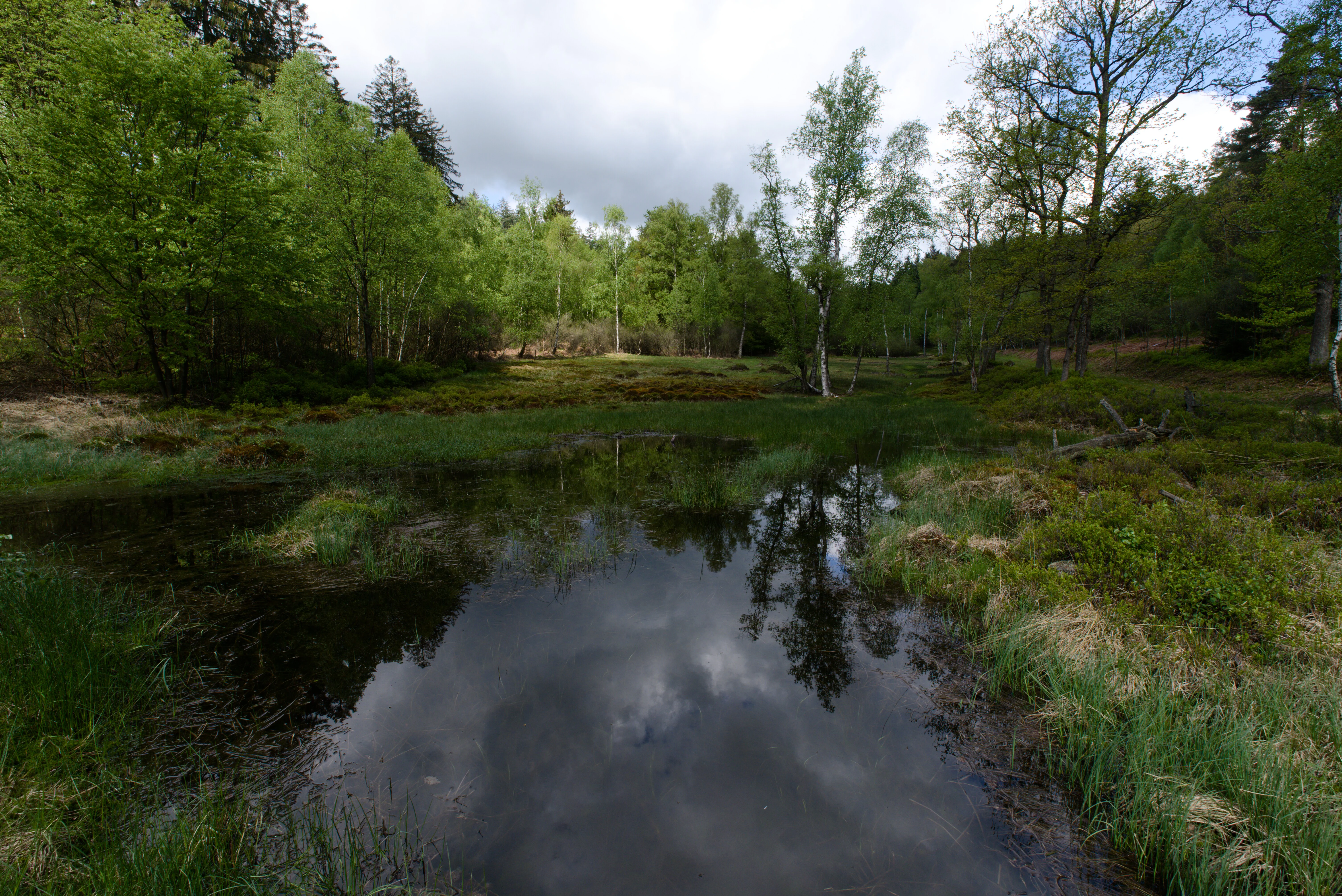
A small natural lake surrounded by green trees and marshy vegetation, reflecting the cloudy sky and trees in its dark water.
A small natural lake surrounded by green forest, reflecting the cloudy sky.

Rotes Wasser von Olfen ecosystems, habitats, and plant life

Ecologically, Rotes Wasser von Olfen represents an unusually complete example of a small-scale mire complex in the Odenwald low mountain range. The reserve combines transitional and lowland bog communities, nutrient-poor wet meadows, mat-grass swards, and patches of low-growing heath vegetation, all packed into a very compact area. This fine-grained mosaic is what makes the site ecologically irreplaceable: each habitat element supports species that depend on the transition zones between them.

The peat-forming core of the reserve is dominated by several species of sphagnum moss, including the deceptive sphagnum, the reddish sphagnum, and the common sphagnum. Among the moss layer grow characteristic bog plants such as hare's-tail cottongrass, cross-leaved heath, common cranberry, and small populations of the round-leaved sundew, an insectivorous plant typical of nutrient-poor mires. The presence of sundew and cottongrass together signals the survival of genuine bog conditions rather than just damp grassland.

Beyond the wet core, the reserve extends into mat-grass swards and dwarf-shrub heaths on slightly drier ground, often bordering the stream or the small pools created by the dams. These dry-to-wet transitions are an important part of the habitat mosaic and are actively maintained through grazing and selective conifer removal. The surrounding forest is predominantly conifer plantation in portions adjacent to the open area, while the wider catchment includes mixed deciduous woodland more typical of the Odenwald.
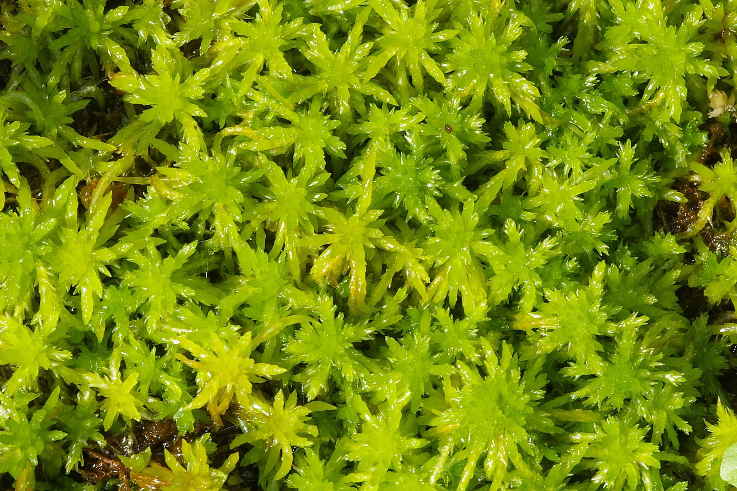
A close-up, top-down view of bright green Sphagnum fallax peat moss growing densely in a star-like pattern.
Close-up view of Sphagnum fallax peat moss, a characteristic species of the Rotes Wasser von Olfen valley bog.

Rotes Wasser von Olfen wildlife and species highlights

The wildlife value of Rotes Wasser von Olfen lies in its combination of bog vegetation with associated invertebrate and amphibian life, rather than in large mammal presence. The common frog is one of the most visible inhabitants of the wet valley and is a typical species of the reserve's standing water and seepage zones. Its presence indicates that the small pools, even those created by stream dams, retain functional amphibian breeding habitat.

Invertebrate life is particularly rich around the open-water sections of the Hinterbach. Several dragonfly species are recorded from the site, including the small whiteface, the black darter, and the four-spotted chaser. These species benefit from the structurally diverse shoreline created by the mix of moss hummocks, floating vegetation, shallow margins, and fluctuating water levels generated by the dams. Such dragonfly assemblages depend on climate-open, sunlit water bodies, which is one of the reasons why conservation efforts focus on keeping surrounding conifer cover in check.

The surrounding forest and heath mosaic also supports typical Odenwald bird and mammal life, although the reserve is small and its contribution to regional fauna is mostly through its unique wet-habitat specialists rather than through forest-interior species. The open heaths and meadows that form part of the wider FFH zone provide additional habitat for grassland invertebrates and pollinators that otherwise struggle in the densely forested Odenwald landscape.

Rotes Wasser von Olfen conservation status and protection priorities

From a conservation perspective, Rotes Wasser von Olfen is significant primarily because it preserves a habitat type that has effectively disappeared elsewhere in the Odenwald. Large-scale drainage, forestry conversion, and land-use change across central Germany have reduced natural mire complexes to tiny fragments, and the systematic biotope mapping that led to the reserve's designation in 1980 confirmed it as the only remaining locality in the entire low mountain range where lowland and transitional bog communities survive in a recognizable mosaic. The IUCN Category IV designation reflects this management priority, recognizing the area as a Habitat and Species Management Area requiring active intervention to maintain its conservation values.

The site's formal integration into the EU Natura 2000 network in 2008 strengthened its status, adding agricultural meadows and surrounding slopes to the protected framework under the Habitats Directive. This enlargement reflects an understanding that the bog's hydrology and species composition depend on the wider catchment, not just the wet core, and that traditionally managed meadows help buffer the site against intensification or abandonment.

Active management within the reserve is aimed at countering the long-term threats typical of small mire sites in low mountain landscapes, including drying-out caused by drainage and forest encroachment. Stream dams hold back water to keep the peat-forming areas saturated, selective felling of conifers opens up the ground to sunlight, and grazing in the wooded northern sector helps expand the dwarf-shrub heath component. Together, these measures show how a small but ecologically irreplaceable German nature reserve is maintained as part of broader European conservation policy.

Rotes Wasser von Olfen cultural meaning and human context

The cultural context of Rotes Wasser von Olfen is shaped less by dramatic history than by its position within the long-standing rural landscape of the inner Odenwald. The surrounding villages of Olfen, Güttersbach, and Affolterbach have historically been small agricultural communities whose use of the valley meadows for hay and pasture continues to the present and is now explicitly recognized as part of the protected FFH landscape. This integration of traditional land use with conservation is typical of long-established Hessian nature reserves embedded in still-active farming landscapes.

Just outside the protected zone, at a junction on the K 47 district road leading past the bog, stands the Olfener Bild, a late-Gothic sandstone wayside shrine. Such Bildstöcke are characteristic cultural features of Catholic and formerly Catholic regions of southern Hesse and the Odenwald, marking crossroads, boundaries, or places of local devotion. While the shrine itself has no direct ecological connection to the bog, it provides a small window into the regional cultural fabric that surrounds the otherwise quiet reserve.

Top sights and standout views in Rotes Wasser von Olfen

Rotes Wasser von Olfen combines very compact size with very high ecological value. Its defining highlights include being the only surviving Odenwald lowland and transitional bog mosaic, its iron-rich reddish seepage waters that give the site its name, and its role as a refuge for specialist bog plants such as sphagnum mosses, cottongrass, and the round-leaved sundew. The reserve's additional value lies in its dragonfly-rich impoundments and its integration into the EU Natura 2000 network through the larger FFH site that includes surrounding grasslands.

Best time to visit Rotes Wasser von Olfen

Because Rotes Wasser von Olfen is a quiet ecological site rather than a tourism attraction, the most informative seasons tend to be late spring and early summer, when water levels are typically stable enough to maintain the impoundments that support dragonflies and amphibians, and the bog flora is at its most visible. Summer generally brings lush growth and good dragonfly activity, particularly along the open sections of the dammed stream. In autumn, the bog heather and cranberry plants become more apparent as the surrounding vegetation dies back, while frost in winter can dramatically highlight the moss hummocks and the contrast between the bog and surrounding forest. Visitors should generally avoid disturbing the sensitive peat-forming sections regardless of season, and access is easiest when forest paths are dry.

Monthly climate preview

Long term representative point temperature and monthly precipitation rhythm for Hessen

Rotes Wasser von Olfen Climate Normals and Measured Annual Temperature Patterns

Historical records from 1991 to 2000 establish the measured baseline for average temperature and monthly precipitation at a representative coordinate in Rotes Wasser von Olfen. Reviewing the complete twelve month climatology profile reveals comprehensive variations across temperature extremes and daily precipitation rhythms.
Annual mean10 °C
0 °C20 °C
Jan
Feb
Mar
Apr
May14°
Jun18°
Jul20°
Aug20°
Sep15°
Oct10°
Nov
Dec
Warmest month
July

20.3 °C

Coolest month
January

0.1 °C

Wettest month
July

2.4 mm/day

Driest month
April

1.5 mm/day

Park location guide

Geography guide, regional context, and park location map for Rotes Wasser von Olfen

Rotes Wasser von Olfen park geography, regions, and map view in Germany

Understand where Rotes Wasser von Olfen sits in Germany through a broader geographic reading of the surrounding landscape, nearby location context, and its mapped position within the national park landscape.

How Rotes Wasser von Olfen fits into Germany

Germany is a federal republic in Western and Central Europe with a population of over 83 million across sixteen constituent states. It is Europe's largest economy by nominal GDP and a major global exporter and importer. The capital is Berlin, and the country borders Denmark, Poland, Czech Republic, Austria, Switzerland, France, Luxembourg, Belgium, and the Netherlands.

Wider geography shaping Rotes Wasser von Olfen in Germany

Germany is located in Western and Central Europe, spanning 357,022 km². It borders Denmark to the north, Poland and the Czech Republic to the east, Austria and Switzerland to the south, and France, Luxembourg, Belgium, and the Netherlands to the west. The country has coastlines on the Baltic Sea and North Sea to the north, with the Alps located in the southern region.

Map view of Rotes Wasser von Olfen

Use this park location map to pinpoint Rotes Wasser von Olfen in Germany, understand its exact geographic position, and read its mapped placement within the surrounding landscape more clearly.

Pigeon | © OpenStreetMap contributors

Location context for Rotes Wasser von Olfen

Hessen

Visualizing the rare bog habitats and iron-rich waterways of the Odenwald hills

Rotes Wasser von Olfen Landscape and Scenery Photography

Visual documentation captures the rare transitional bog communities and iron-stained waters defining the Rotes Wasser von Olfen protected valley. Photographic records reveal the stark contrast between open mire hollows and steep surrounding forest ridges across the Odenwald landscape.

A top-down close-up view of a round-leaved sundew plant with reddish, dew-covered tentacles surrounded by green and brown moss.

A close-up photograph of dense, reddish-brown Sphagnum capillifolium moss with some green moss visible in the background and a small white feather-like object resting on the right side.

A small natural lake surrounded by green trees and marshy vegetation, reflecting the cloudy sky and trees in its dark water.

A close-up, top-down view of bright green Sphagnum fallax peat moss growing densely in a star-like pattern.

Park atlas

Compare nearby regional nature reserves and surrounding valley habitats

Parks Near Rotes Wasser von Olfen, Exploring Related Protected Landscapes

Browse other protected areas near Rotes Wasser von Olfen to examine similar wetland geography and low mountain terrain. Compare adjacent conservation zones and regional park networks across the surrounding Odenwald hills.
A horizontal watercolor illustration of a soft, rolling landscape with a central winding path or stream, green meadows, distant hills, and foreground trees and flowers.
Nature reserveHesse
About 3.3 km away#1 closest

North

Gras-Ellenbacher Wiesen Nature Reserve: Protected Valley Basin Geography and Map Overview

Wet meadows and seepage habitats within the Odenwald hills

Situated in a gentle hollow near the Dachsberg and Kirchberg ridges, Gras-Ellenbacher Wiesen represents an essential Hessian nature reserve. This overview highlights the interplay between the Ulfenbach stream, drainage infrastructure, and traditional meadow management that defines this distinct sandstone upland protected landscape.

Area
0.241 km²
Established
1981
IUCN
IV
Relief
Upland
Watercolor painting of soft, rolling green hills and meadows in a minimalist style, set against a light background.
Nature reserveHessen
About 5.1 km away#2 closest

South

Dürr-Ellenbachtal von Wald-Michelbach: Odenwald Nature Reserve and Protected Valley Geography

A historic meadow valley in Hessen, Germany

The Dürr-Ellenbachtal von Wald-Michelbach nature reserve protects an elongated, narrow valley framed by forested ridges in the central Odenwald. This area is defined by its meandering brook, diverse alder stands, and species-rich meadows that sustain significant local biodiversity. As a key Natura 2000 site, it serves as an essential example of protected meadow landscapes and rural mountain terrain within the Bergstraße district.

Area
0.542 km²
Established
1990
IUCN
IV
Relief
Mountain
Watercolor painting of a gentle, rolling green landscape with sparse trees and distant hills on a white background.
Nature reserveHesse
About 9 km away#3 closest

Southeast

Jakobsgrund bei Gammelsbach Nature Reserve: Geographic Atlas and Park Boundary Mapping

Protected sandstone valley landscapes in southern Hesse

This nature reserve in the Odenwald hills provides a concentrated example of traditional valley land use. The area features a sharp contrast between dry south-facing slopes and damp, stream-carved lowlands, creating a botanical hotspot within the regional geography of Hesse, Germany.

Area
0.095 km²
Established
1996
IUCN
IV
Relief
Upland
A wide watercolor illustration showing a river curving through a grassy valley with trees and hills in the background.
Nature reserveHessen
About 9.6 km away#4 closest

West

In der Erbach bei Mörlenbach Nature Reserve: Protected Odenwald Stream Valley

Regional geography and habitat mapping in southern Hessen

The In der Erbach bei Mörlenbach nature reserve preserves a well-defined side-valley ecosystem within the broader Odenwald landscape. Its protected boundaries encompass a moisture-rich corridor featuring wet meadows, reedbeds, and forest edges that exemplify the traditional cultural geography of the Weschnitz river basin in southern Germany.

Area
0.197 km²
Established
1997
IUCN
IV
Relief
Upland
A watercolor painting depicting a soft-focus, light-colored landscape of rolling green hills, clustered trees, and a gentle stream valley.
Nature reserveHessen
About 9.9 km away#5 closest

Southwest

Eiterbachtal von Wald-Michelbach Nature Reserve in the Central Odenwald Uplands

A protected stream-valley landscape in the Bergstraße district of Hessen

Eiterbachtal von Wald-Michelbach protects a near-natural stream environment characterized by its meandering course, alder-ash gallery forests, and diverse tall-herb meadow communities. This nature reserve provides essential habitat in the southern Odenwald, showcasing the interplay between hydrological stream processes and sandstone forest edges within the Hessen region.

Area
0.473 km²
Established
1983
IUCN
IV
Relief
Upland
Nature reserveHesse
About 9.9 km away#6 closest

Southwest

In der Striet bei Vöckelsbach Nature Reserve: Regional Geography and Mapped Protected Landscapes

A compact forest and wetland mosaic in the Odenwald of southern Hesse

The nature reserve In der Striet bei Vöckelsbach is an essential protected area covering four and a half hectares of valley floor. It provides a dense habitat gradient from reeded spring zones through alder forests to mixed deciduous slopes. This record details the park landscape, stream systems, and its integration into the larger Geo Naturpark Bergstraße Odenwald and Natura 2000 protected areas.

Area
0.048 km²
Established
1988
A soft, horizontal watercolor painting depicting a meandering stream flowing through green meadows and rolling hills under a pale sky.
Nature reserveHesse
About 10 km away#7 closest

South

Finkenbachtal bei Finkenbach Nature Reserve: Mapped Brook Valleys of the Odenwald

Protected stream corridor and floodplain meadows in southern Hesse

Finkenbachtal bei Finkenbach preserves a compact, ecologically intact valley system characterized by meandering sandstone brook morphology and traditional floodplain meadow management. This protected area serves as a significant link in the regional Odenwald stream network, illustrating the intersection of low mountain forest and valley floor vegetation dynamics.

Area
0.276 km²
Established
1981
Relief
Upland
Climate
Temperate
Watercolor painting of a green wetland landscape with a winding stream and distant hills in soft pastel colors.
Nature reserveHesse
About 11 km away#8 closest

West

Albersbacher Riedwiesen Nature Reserve: Mapped Geography and Protected Landscapes in Hesse

A detailed atlas view of the Albersbach stream valley conservation corridor.

Situated in the Weschnitz valley region of Hesse, the Albersbacher Riedwiesen nature reserve offers a concentrated look at traditional Odenwald landscapes. The area protects a unique combination of wet meadows, reedbeds, and dry grasslands that follow the natural meandering course of the Albersbach stream, providing a vital study in local geomorphology and conservation geography.

Area
0.124 km²
Established
1996

Common questions about visiting, size, designation, and location context for Rotes Wasser von Olfen

Rotes Wasser von Olfen FAQs for park facts, access, geography, and protected area context

Find quick answers about Rotes Wasser von Olfen, including protected-area facts, park geography, trail and visitor context, and how the park fits into its surrounding country and regional landscape.
MoriAtlas Explorer

Continue Your Protected Areas Search Across the Global Atlas

Deepen your exploration by continuing the structured search for national parks and protected areas worldwide. Utilize the comprehensive filtering capabilities to compare different conservation landscapes and refine your understanding of global park geography. Discover more about the distribution and characteristics of protected natural areas.

Global natural geography