Mori Atlas logo
Wildlife reserveRousay

Explore the distinct island geography, mapped cliff formations, and protected bird habitats of this northern archipelago sanctuary.

Rousay Wildlife Reserve: An Atlas of Protected Coastal Landscapes and Upland Terrain in Orkney

Rousay stands as a prominent protected entity within the Orkney archipelago, defined by its contrast between rugged interior moorlands and a narrow coastal strip of cultivated land. This island landscape encompasses significant freshwater lochs, extensive cliff systems, and vital marine environments across the surrounding sounds. By examining the geographic boundaries and terrain patterns, users gain insight into the ecological character and preserved natural heritage of this northern Scottish wildlife reserve.

Orkney IslandsScottish islandarchaeological sitesNorse heritagebrochschambered cairns

Rousay

Wildlife reserve

Park overview

Structured park overview, official facts, and landscape profile for Rousay

Rousay park facts, protected area profile, and essential visitor context

Review the core facts for Rousay, including designation, size, terrain, visitor scale, habitats, and operating context in one park-focused overview.

About Rousay

Rousay is one of the inhabited islands of the Orkney archipelago, positioned a short ferry ride north of Mainland, Orkney and forming part of the same broad chain of islands that has been continuously inhabited since Neolithic times. Its personality is shaped by a striking contrast between a rugged, hilly interior and a narrow, fertile coastal fringe where most settlement, farmland, and roads are concentrated. A single road loops the island for roughly 23 kilometres, passing through quiet crofting landscapes, cliff-edge viewpoints, and clusters of archaeological monuments that have made Rousay famous well beyond Scotland.

The island's archaeological wealth is one of its defining features. Over 100 sites have been recorded, spanning thousands of years of human activity: Neolithic chambered cairns such as Blackhammer, Taversoe Tuick, and Knowe of Yarso, Iron Age brochs including the dramatic Midhowe Broch on the west coast, Viking boat burials, and medieval church ruins. This density of monuments, combined with the island's accessibility, has made Rousay a focal point for visitors interested in prehistoric and Norse Scotland.

Rousay is also a place of strong ecological value. Its cliffs, moorland, and freshwater lochs provide breeding habitat for seabirds and moorland species, while the surrounding sounds shelter marine communities built around maerl beds. The island's protected status, both as a Site of Special Scientific Interest and through the surrounding Nature Conservation Marine Protected Area, reflects an enduring balance between continued human use, including farming, fishing, and crofting, and conservation of its natural and archaeological heritage.

Quick facts and research context for Rousay

Rousay is the fifth largest island in the Orkney group, covering roughly 4,860 hectares, and lies just north of Mainland, Orkney across Eynhallow Sound. It is the second hilliest Orkney island after Hoy, with summits including Blotchnie Fiold and both Keirfea and Knitchen exceeding 229 metres. The island is a designated Site of Special Scientific Interest, hosts an RSPB bird reserve, and contains an Important Bird Area recognised by BirdLife International.

The population in the most recent census stood at around 236, with most residents working in farming, fishing, fish-farming, craft trades, or seasonal tourism. An island-circling road of about 23 km connects its scattered settlements, and a ro-ro ferry from Tingwall on Mainland links Rousay with Egilsay and Wyre. Following its Norse past, Rousay's name derives from the Old Norse Hrólfsey, meaning Rolf's island.

Protection and recognition

Explore official designation history and documented conservation frameworks

Rousay Protection Status And International Recognition Records

Rousay maintains documented protection status established in 2014 alongside imported Natura 2000 recognition sources. Official designation records outline mixed protection scope and international conservation frameworks.

International recognition

Protection details

Protection scope
Mixed
Designated year
2014
Transboundary protection
No
Park context

Deeper park guide and search-rich context for Rousay

Rousay history, landscape, wildlife, and travel context

Explore Rousay through its history, landscape character, ecosystems, wildlife, conservation priorities, cultural context, and seasonal travel timing in a structured park guide built for atlas discovery and search intent.

Why Rousay stands out

Rousay is best known for the sheer concentration and diversity of its archaeological sites, which has earned it the popular nickname the "Egypt of the North." On its shores and interior, visitors can find Neolithic settlements, Bronze Age burnt mounds, Iron Age brochs and crannogs, Viking-age boat burials, medieval church remains, and a later stately home, with the Midhowe Broch and Midhowe Chambered Cairn complex standing out as particularly spectacular examples. The island is equally recognised for its natural environment, particularly its dramatic cliff scenery, inland freshwater lochs such as Muckle Water, and protected bird populations that have led to its SSSI status and BirdLife International designation. The surrounding waters of Rousay Sound, together with Wyre Sound, are recognised as a marine protected area for their maerl beds and associated marine life.
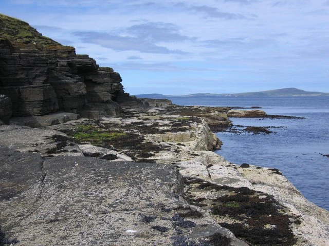
Rugged, layered rocky cliffs on the left sloping down to a low, flat shoreline bordering the sea, with distant islands visible across the water under a cloudy sky.
Rocky cliffs and coastline at Saviskaill Bay on the island of Rousay.

Rousay history and protected-area timeline

Rousay has a layered human history stretching back to the Neolithic period, when the earliest known settlement was established at Rinyo. Successive cultures left a remarkably complete sequence of remains: Bronze Age burnt mounds, Iron Age crannogs and brochs, Viking-age boat burials, and medieval church sites, with three brochs lying within a short stretch of the coastline, the highest broch density anywhere in Scotland.

The island takes its name from Old Norse Hrólfsey, meaning Rolf's island, and its place-name record shows the gradual evolution of the name across centuries, with the form Rousay first appearing in written sources in 1549. Place names throughout the island reflect this Norse heritage and have been documented extensively by scholars such as Hugh Marwick.

In the 19th century, Rousay supported a population of over 900 people and a thriving rural economy of farmers, fishermen, blacksmiths, joiners, and other tradespeople. That era was disrupted by a series of crofting clearances along the western coast ordered by landowner George William Traill in the 1820s and 1830s, which contributed to dramatic depopulation. His nephew, General Sir Frederick Traill-Burroughs, later inherited and expanded the family estates, commissioning improvements including a pier, schools, a public market, the first steamship service, a post office, and a resident doctor. The mid-20th century saw depopulation continue, reaching a historic low of 181, before renewed settlement from the 1970s onward gradually restored the community to its present size.

Rousay landscape and geographic character

The landscape of Rousay is defined by a strong contrast between a hilly interior and a narrow coastal strip of cultivated land. The island is the second highest in Orkney after Hoy, with summits including Blotchnie Fiold and the twin peaks of Keirfea and Knitchen, all above roughly 229 metres. From these heights, visitors are rewarded with broad views across neighbouring islands and the surrounding Atlantic waters.

Most of the island's arable farmland lies in a relatively short distance between the coastline and the encircling road, producing a pattern where settlement and fields cling to the shore while the interior rises into moorland and rough upland. The coast itself is varied, with long cliff sections such as those visible from Saviskaill Bay looking north toward Westray, gentler bays, and stretches where the cliffs drop directly into the sea. Inland, several freshwater lochs, including Muckle Water, the largest, add quieter features to the terrain.

Rousay ecosystems, habitats, and plant life

Ecologically, Rousay is recognised through its Site of Special Scientific Interest status, which highlights both its cliff formations and its wildflower communities. The combination of maritime cliffs, moorland, freshwater lochs, and small inlets produces a varied habitat matrix for both plants and animals.

Vegetation on the island reflects the typical Orkney pattern of coastal grassland giving way to moorland and rough grazing inland, while pockets of cultivated and crofted land add diversity along the shore. Wetland and lochside habitats, particularly around the larger lochs such as Muckle Water, support characteristic plant communities for the region. The cliffs provide nesting habitat for breeding seabirds, and the moorland supports ground-nesting species that have earned parts of the island formal conservation recognition.

Rousay wildlife and species highlights

Rousay's wildlife reflects its mix of marine, cliff, moorland, and freshwater environments. Among mammals, grey seals and European otters are recorded around the island's shores, indicating healthy inshore populations in the surrounding sounds.

The island is of particular importance for birds. An RSPB bird reserve is present, and around 630 hectares have been formally recognised as an Important Bird Area by BirdLife International for their populations of breeding moorland birds, including Arctic terns. Beyond terns, the cliffs and moorland host a broader community of breeding seabirds and upland species typical of northern Scotland. In the waters of Rousay Sound and the neighbouring Wyre Sound, maerl beds, since designated as a marine protected area, shelter peacock worms, sponges, small fish, shrimps, gobies, and crabs.

Rousay conservation status and protection priorities

Rousay's conservation significance operates at several scales, from terrestrial to marine. The island as a whole has been notified as a Site of Special Scientific Interest, giving formal recognition to its cliff formations, wildflower communities, and broader ecological character. The RSPB's presence adds a focused layer of bird-specific protection, and BirdLife International's Important Bird Area designation acknowledges the international value of the island's breeding moorland and seabird populations.

Marine conservation has become increasingly important around Rousay. Since 2014, Rousay Sound and the nearby Wyre Sound have been designated as Nature Conservation Marine Protected Areas, protecting maerl bed habitats and the species they support. Within these marine protected areas, fishing activities are regulated, with dredging, beam trawling, demersal trawling, and seine fishing prohibited. Together, these designations place Rousay within a network of terrestrial and marine protections that safeguard its scenic, ecological, and archaeological character.

Rousay cultural meaning and human context

Rousay carries a strong Norse cultural inheritance, visible not only in its recorded history and place names but also in the everyday geography of the island. The name itself evolved from the Old Norse Hrólfsey over many centuries, and the patterns of settlement, land tenure, and traditional crofting reflect the long Norse influence on Orkney as a whole.

The island's more recent cultural life has been shaped by crofting, fishing, and rural trades, as well as by the legacy of 19th-century landowners whose decisions on rent, clearance, and improvement left a lasting imprint on the community. In the modern era, Rousay has drawn writers, artists, and creative visitors, including the poet Edwin Muir, who recalled encountering the local landowner in childhood, and Pauline Stainer, who published a poetry collection about the island, while patrons such as Margaret Gardiner helped link Rousay's artistic life to the broader Orkney cultural scene, including the Pier Art Gallery in Stromness.

Top sights and standout views in Rousay

Rousay's highlights centre on its extraordinary archaeological landscape, its upland scenery, and its protected natural environment. The Midhowe Broch and Midhowe Chambered Cairn complex is among the most spectacular monuments in Orkney, while multiple chambered cairns across the island offer a rare concentration of Neolithic tombs within walking distance of the coast. Three Iron Age brochs within a short stretch of shoreline give Rousay the highest broch density in Scotland.

Beyond archaeology, the island rewards visitors with sweeping views from Blotchnie Fiold and the surrounding peaks, cliff-edge walks along routes such as those near Saviskaill Bay, and encounters with breeding seabirds, moorland species, seals, and otters. The surrounding marine protected areas add an underwater dimension to the island's conservation significance, while a slow loop of the island's single road reveals crofting landscapes, lochs, scattered settlements, and quiet shorelines characteristic of rural Orkney.

Best time to visit Rousay

Rousay has a mild northern maritime climate typical of Orkney, with relatively cool summers and mild winters, and light levels that vary dramatically across the year. Late spring and summer generally offer the longest days, the most comfortable conditions for walking the coastal archaeological sites, and the best chances of seeing breeding seabirds and wildflowers in full display around the cliffs and moorland.

Autumn can bring quieter conditions and a different atmospheric quality, with shifting light over the island's uplands and sounds, while winter visits have their own stark appeal, though ferry sailings and daylight hours are reduced. For those prioritising wildlife, the breeding season for terns and other seabirds tends to be a particularly rewarding period, while those interested in archaeology and landscape will find the longer daylight months of late spring and summer the most comfortable for exploring the island's many sites.
Monthly climate preview

Long-term representative averages for annual temperature and precipitation rhythm

Rousay Climate Normals and Measured Monthly Weather Patterns

Historical temperature records track representative baseline averages from 1991 to 2020 across twelve measured intervals. Examining the complete monthly precipitation profile reveals detailed shifts in regional climate conditions.
Annual mean9 °C
6 °C13 °C
Jan
Feb
Mar
Apr
May
Jun11°
Jul13°
Aug13°
Sep12°
Oct10°
Nov
Dec
Warmest month
August

13.3 °C

Coolest month
February

5.5 °C

Wettest month
October

3.9 mm/day

Driest month
May

2.1 mm/day

Park location guide

Geography guide, regional context, and park location map for Rousay

Rousay park geography, regions, and map view in United Kingdom

Understand where Rousay sits in United Kingdom through a broader geographic reading of the surrounding landscape, nearby location context, and its mapped position within the national park landscape.

How Rousay fits into United Kingdom

The United Kingdom is a parliamentary constitutional monarchy located in northwestern Europe, consisting of four constituent countries: England, Scotland, Wales, and Northern Ireland. As a major global power with over 69 million residents, it maintains significant international influence in politics, economics, and culture.

Wider geography shaping Rousay in United Kingdom

The United Kingdom is an island nation located in northwestern Europe, surrounded by the Atlantic Ocean, North Sea, English Channel, Celtic Sea, and Irish Sea. It shares a land border with the Republic of Ireland to the west. The territory includes the island of Great Britain, the northeastern portion of Ireland, and most of the smaller British Isles islands.

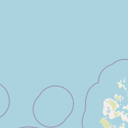
Map view of Rousay

Use this park location map to pinpoint Rousay in United Kingdom, understand its exact geographic position, and read its mapped placement within the surrounding landscape more clearly.

Pigeon | © OpenStreetMap contributors

Location context for Rousay

OrkneyScotland

Visual Reference for Island Scenery, Coastal Cliffs, and Upland Habitats

Rousay Photos and Protected Landscape Imagery

Visual documentation of Rousay reveals the dramatic character of its coastal cliffs, freshwater lochs, and upland terrain. Studying these protected landscapes helps interpreters understand the unique geography and archaeological heritage of the Orkney archipelago.

Rugged, layered rocky cliffs on the left sloping down to a low, flat shoreline bordering the sea, with distant islands visible across the water under a cloudy sky.

Ancient stone structure of Midhowe Broch showing circular walls and interior chambers next to the grassy coastline.

Park atlas

Compare adjacent coastal terrain and island habitats across the surrounding archipelago

Exploring Parks Near Rousay and Connected Regional Protected Landscapes

Browsing other protected areas near Rousay reveals similar coastal cliffs, glacial uplands, and marine habitats across the surrounding region. Extending the geographic comparison helps trace broader island conservation patterns and regional park geography.
A minimalist, stylized vector illustration of coastal cliffs meeting the sea, with a lighthouse visible in the distance on top of the headland.
Marine protected areaHighland
About 73 km away#1 closest

South

Noss Head Marine Protected Area: Highland Coastal and Benthic Geography

Exploring the rocky cliffs and offshore mussel habitats of Northern Scotland.

Noss Head is a notable marine protected area located on the Caithness coast of the Scottish Highlands. The site is defined by its rugged coastal cliffs and an expansive, nationally important horse mussel bed that occupies the seabed at depths between 35 and 45 metres. This area represents a core study in North Atlantic benthic ecology and dramatic maritime landforms.

Area
8 km²
Established
2014
IUCN
IV
Relief
Lowland
Nature reserveScotland
79 km away#2 closest

South

East Caithness Cliffs Nature Reserve: Regional Geography and Coastal Protected Area Atlas

Coastal sandstone cliffs and maritime heath habitats in northern Scotland.

Examine the layered conservation architecture and physical geography of East Caithness Cliffs. This site serves as a prime example of protected northern coastal terrain, where sandstone formations and maritime heath support vast seabird populations across a mosaic of land and sea boundaries.

Area
116.96 km²
Established
1996
Relief
Upland
Climate
Temperate
A watercolor painting showing a wide, sweeping landscape of green hills, a winding stream, and flat boggy terrain under a soft, light-colored sky.
Nature reserveScotland
About 89 km away#3 closest

Southwest

Flow Country: Geography and Protected Landscape Analysis of Scotland's Blanket Bog

Northern Scotland's vast, waterlogged peatland ecosystem.

The Flow Country is defined by its extensive, open peatland terrain stretching across Caithness and Sutherland. This nature reserve serves as a critical geographic study area for understanding blanket bog formation, carbon storage, and the restoration of fragile wetland habitats in northern Europe.

Area
4,000 km²
Relief
Lowland
Scope
Terrestrial
Water
Water-dominated
Marine protected areaShetland
About 123 km away#4 closest

Northeast

Boddam Marine Protected Area: A Geographic Profile of Southern Shetland Coastal Waters

Coastal conservation landscapes and North Atlantic marine ecology

Located on the southern Mainland of Shetland, the Boddam Marine Protected Area stands as a vital site for marine conservation. The region is widely recognized for its consistent sandeel populations, which provide essential nourishment for seabirds and predatory marine mammals. This site combines a rich Norse crofting history with a sheltered maritime geography, offering a window into the interconnectedness of land and sea in the northern reaches of Scotland.

Relief
Lowland
Water
Major water bodies
A soft watercolor painting of the island of Mousa in Shetland, depicting green and tan grassy hills surrounded by water, with the tall stone silhouette of the Mousa Broch visible on the island.
Wildlife reserveShetland Islands
About 133 km away#5 closest

Northeast

Mousa, Shetland Wildlife Reserve: Mapping the Geography of a Northern Coastal Protected Area

Ancient broch ruins and critical island wildlife habitat

Mousa, Shetland provides a unique look at isolated island geography, featuring layered sedimentary geology and a high-density seabird ecosystem. Gain geographic insight into this protected site, encompassing historical Iron Age structures alongside vital nesting grounds located within the broader marine landscape of the Shetland archipelago.

Area
1.8 km²
Relief
Lowland
Climate
Temperate
Access
Moderate access
A wide watercolor illustration showing a mountain range in the distance, a valley, and green forests on either side, with soft pastel colors.
Protected landscapeHighland
About 134 km away#6 closest

Southwest

North West Sutherland National Scenic Area: Mapping the Peaks and Coasts of Highland Scotland

Protected quartzite mountain landscapes and Atlantic coastal geography

This detailed overview of the North West Sutherland National Scenic Area maps the dramatic interplay between the white quartzite mountains of Foinaven and Arkle and the darker Lewisian gneiss that forms the underlying Highland landscape. The analysis provides deep insights into the region's knock and lochan topography, sea lochs, and the protected coastal habitats of Handa Island, anchoring the area within its broader Scottish geological context.

Area
266 km²
Established
1981
Relief
Mountain
Climate
Temperate
Watercolor painting of soft rolling dunes, green hills, and light clouds.
Protected areaSutherland
About 145 km away#7 closest

Southwest

Coul Links Protected Area: Coastal Dune and Heathland Geography in Sutherland, Scotland

A study of coastal dune succession and wetland terrain

Coul Links serves as a quintessential example of a Scottish coastal links landscape, tracing a continuous path from active beach fronts through to stable, juniper-rich heathland. Situated in Sutherland, the site offers a window into the formation of dune slacks, seasonal freshwater lochans, and the ecological dynamics of a complex, interwoven coastal system.

Relief
Lowland
Climate
Temperate
Access
Easy access
Scope
Terrestrial
Wildlife reserveShetland Islands
185 km away#8 closest

Northeast

Fetlar Wildlife Reserve and North Isles Geography: A Detailed Protected Area Overview

Coastal terrain and ecological sanctuary in the Shetland Islands

Fetlar is a remarkable protected landscape in the Shetland Islands, famously known as the Garden of Shetland for its unusually fertile soil and plant diversity. This geographic entry documents the island's role as a critical seabird refuge and its complex coastal environment, providing essential context on the physical boundaries and historical landmarks like the Funzie Girt that define this North Atlantic isle.

Area
40.78 km²
Relief
Upland
Climate
Temperate
Access
Moderate access

Common questions about visiting, size, designation, and location context for Rousay

Rousay FAQs for park facts, access, geography, and protected area context

Find quick answers about Rousay, including protected-area facts, park geography, trail and visitor context, and how the park fits into its surrounding country and regional landscape.
MoriAtlas Explorer

Continue Your Protected Areas Search Across the Global Atlas

Deepen your exploration by continuing the structured search for national parks and protected areas worldwide. Utilize the comprehensive filtering capabilities to compare different conservation landscapes and refine your understanding of global park geography. Discover more about the distribution and characteristics of protected natural areas.

Global natural geography