

Mori Atlas logo
Natural monumentRoznitál

Tracing the mapped boundaries and thermophilic plant biodiversity of this rare Central European refuge

Roznitál Natural Monument: A Protected Steppe Habitat Island in the South Moravian Countryside

(Přírodní památka Roznitál)

Roznitál serves as a critical protected natural monument located in the Vyškov district of the South Moravian region in the Czech Republic. This site functions as an isolated ecological island, preserving relict steppe vegetation and heat-loving flora such as the large-flowered pasqueflower and branched St. Bernard's lily amidst an intensely cultivated agricultural landscape. The reserve demonstrates how small, strategically managed parcels of land maintain vital biodiversity in Central Europe.

natural monumentthermophilic floradry grasslandsteppe vegetationhabitat islandagricultural mosaic

Roznitál

Natural monument

Park overview

Structured park overview, official facts, and landscape profile for Roznitál

Roznitál park facts, protected area profile, and essential visitor context

Review the core facts for Roznitál, including designation, size, terrain, visitor scale, habitats, and operating context in one park-focused overview.

About Roznitál

Roznitál belongs to the network of small, ecologically focused nature reserves that the Czech Republic uses to preserve relict habitats in intensively used agricultural landscapes. The site is classified as a přírodní památka, a national designation for natural monuments of limited areal extent but clear conservation value, and it is assigned to IUCN Category IV, indicating an area managed primarily for the protection of particular species or habitats.

Geographically, the reserve lies in the southern half of the Vyškov district, in the transitional zone between the rolling foothills of the Drahanská vrchovina and the warmer lowlands of central Moravia. Its position at relatively low elevation, combined with a mild regional climate, creates the warm microclimate that supports its thermophilic vegetation. The protected plot occupies a small section of land that escaped conversion to cropland, allowing a community of dry grassland and open scrub-steppe plants to persist.

From an ecological standpoint, Roznitál represents what conservation biologists often refer to as a habitat island. The plot is encircled on all sides by agricultural soils, which means that species confined to it cannot easily disperse across the wider landscape. This makes the reserve both fragile and disproportionately important: a single undestroyed patch can sustain populations of rare plants and insects that would otherwise have vanished from the surrounding region.

Because the area is so small and so heavily influenced by external land use, the future of Roznitál depends on deliberate, ongoing management. Without periodic intervention to prevent the encroachment of shrubs and tree seedlings, the open character of the habitat would gradually be lost through natural succession, and the thermophilic flora that the reserve was created to protect would shade out.

Quick facts and research context for Roznitál

Roznitál is a Czech přirodní památka, a category of small protected natural monument, administered by the Jihomoravský kraj regional authority. It was declared on 1 July 1990 by the former Okresní národní výbor Vyškov and is registered under code 1484 in the national nature conservation database. The site covers approximately 1.03 hectares at an elevation of about 340 to 350 meters above sea level, placing it within the warm, low-lying landscapes of central Moravia south of the Drahanská vrchovina highlands.

Protection and recognition

Explore documented terrestrial protection metrics and conservation history for Roznitál.

Roznitál Protection Status and International Recognition Data

Conservation records for Roznitál outline terrestrial protection parameters and documented management frameworks. Official designation details trace the regulatory baseline established for this protected landscape.

Protection details

Protection scope
Terrestrial
Park context

Deeper park guide and search-rich context for Roznitál

Roznitál history, landscape, wildlife, and travel context

Explore Roznitál through its history, landscape character, ecosystems, wildlife, conservation priorities, cultural context, and seasonal travel timing in a structured park guide built for atlas discovery and search intent.

Why Roznitál stands out

Roznitál is best known for its exceptionally well-preserved thermophilic flora community, a relict assemblage of warmth-loving herbaceous plants that survive here as an isolated patch surrounded by intensively farmed fields. Notable species include branched St. Bernard's lily (Anthericum ramosum) and the large-flowered pasqueflower (Pulsatilla grandis), both of which are characteristic of dry grasslands and open steppe habitats in southeastern Central Europe. The site also provides habitat for bird species tied to these open, warm, herbaceous environments. Its broader significance lies in the contrast it presents to the surrounding agricultural matrix. In a region where centuries of ploughing have largely eliminated dry grassland and steppe-like vegetation, Roznitál serves as a living reminder of the original character of the Moravian lowland countryside and as a reservoir of plant genetic diversity that has otherwise largely vanished from the wider countryside.
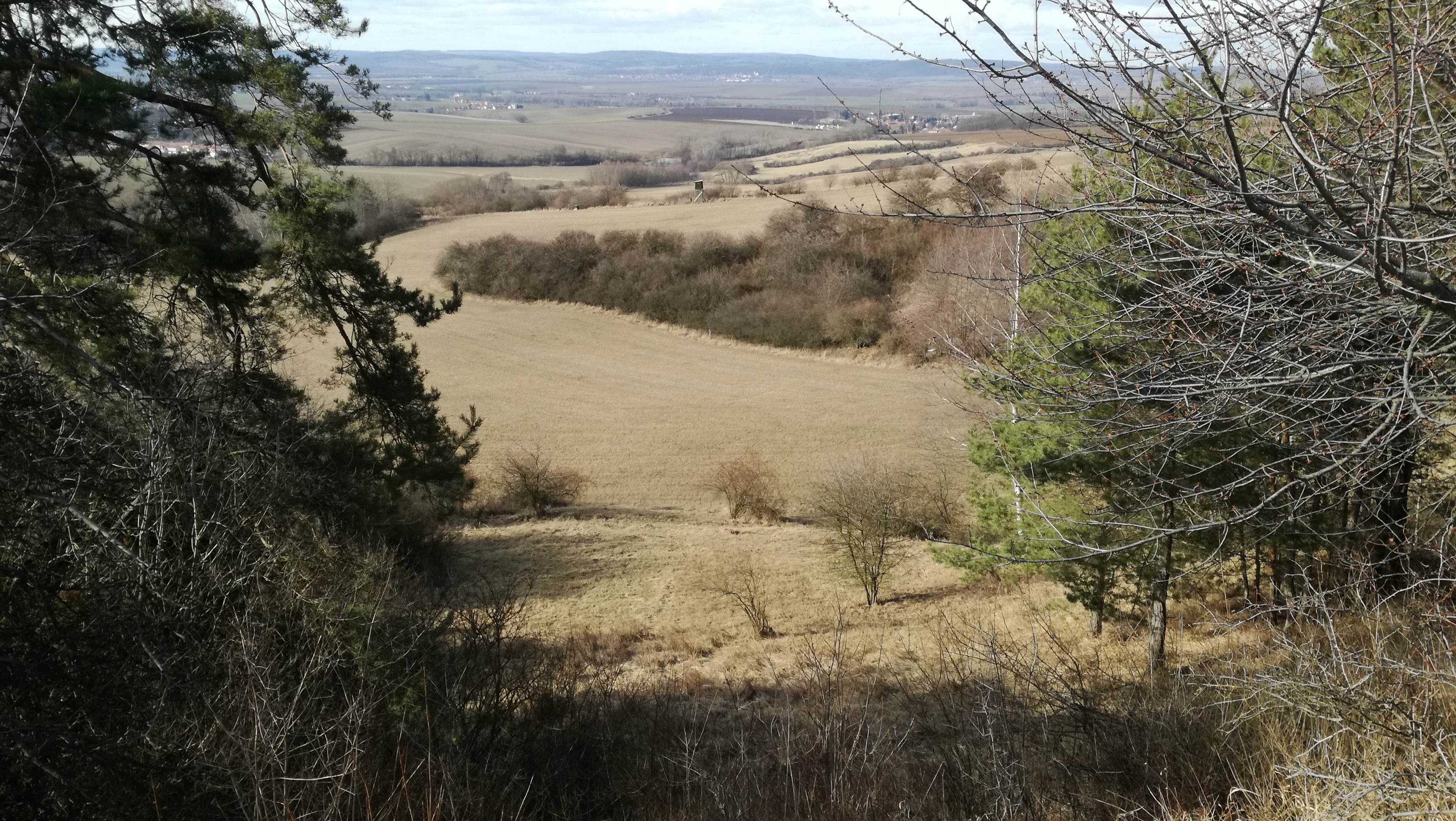
Roznital view from the east
View of the Roznital natural monument

Roznitál history and protected-area timeline

Roznitál was formally declared a protected natural monument on 1 July 1990, at a time when Czechoslovakia's nature conservation system was being reorganized to integrate small, ecologically valuable sites into the national framework. The declaration was issued by the Okresní národní výbor Vyškov, the district national committee that handled local administrative and environmental matters before the reorganization of Czech governance in the early 1990s. Today the site falls under the responsibility of the Krajský úřad Jihomoravského kraje, the regional authority of South Moravia.

The reserve was established specifically because the small patch of land had retained a relict assemblage of thermophilic plants and associated bird species, surrounded by land that had otherwise been converted to cultivation. Recognizing that such an island of original flora would be lost without active protection, conservation authorities chose to formalize its status, placing it into the national nature conservation registry under identification code 1484.

Beyond its formal designation, the documented history of Roznitál is largely the history of its botanical inventory. It appears in regional literature on protected areas of the Vyškov district, including Jiří Kopřiva's 1999 publication Chráněná území okresu Vyškov, which describes the site among the smaller natural monuments of the district. There is little evidence of major changes to the reserve's boundaries or status since 1990, and the principal narrative is one of careful, continuing management rather than dramatic events.

Roznitál landscape and geographic character

Roznitál occupies a tiny parcel of gently undulating terrain in the warm, low-lying agricultural landscape of central Moravia. The site lies at roughly 340 to 350 meters above sea level, on landforms that are relatively subdued by the standards of the broader Moravian topography. There are no dramatic cliffs, peaks, or water features within the reserve itself; instead, the land rises and falls in modest slopes typical of the transition zone between the Drahanská vrchovina highlands to the north and the lower basins to the south.

What defines the landscape character of Roznitál is not the internal relief, but the contrast between the reserve and its surroundings. From every direction, the plot meets cultivated fields, so that the protected area appears as a distinct ecological island set against a uniform backdrop of ploughed land, seasonal crops, and rural infrastructure. The visual impression is of a small, sometimes shrubby meadow-patch surrounded by an agricultural mosaic of cultivated fields, lanes, and the scattered villages of Moravské Málkovice and Orlovice.

Within the reserve itself, the surface is shaped by the requirements of its thermophilic flora. Open, sun-exposed ground with sparse vegetation cover, low herbaceous plants, and patches of bare or stony soil dominate. A scattering of shrubs and young trees may be present, but these are largely the result of woodland encroachment that active management seeks to control. The overall effect is of a warm, dry, light-filled open habitat wedged into a working agricultural countryside.

Roznitál ecosystems, habitats, and plant life

Roznitál is fundamentally a refuge for thermophilic, or warmth-loving, vegetation that has become rare in the modern Moravian landscape. The plant community preserved here belongs to the broad category of Central European dry grasslands and open steppe habitats, which historically occupied south-facing slopes and limestone-rich soils across southeastern Central Europe but have been drastically reduced by agricultural intensification.

Common characteristics of this habitat type include low-growing, drought-tolerant herbaceous plants, a high proportion of species with deep taproots or narrow, tough leaves adapted to summer heat, and a sparse canopy that allows intense sunlight to reach the soil. Such communities typically bloom in late spring and early summer, taking advantage of moisture and warmth before the hottest part of the year. The presence of species such as Anthericum ramosum and Pulsatilla grandis confirms that Roznitál preserves a recognizable fragment of this once-widespread vegetation type.

Beyond its core plant community, the site functions as a small refugium for the invertebrates, pollinators, and ground-nesting birds that depend on open, warm habitats. Because such conditions have become scarce in the intensively farmed Vyškov district, the reserve provides living space for species that the surrounding agricultural matrix can no longer support. The ecological value of Roznitál therefore lies less in its size than in the rarity of the habitat type it maintains within a heavily modified region.

Roznitál wildlife and species highlights

Wildlife information for Roznitál centers particularly on the bird species associated with its thermophilic, open habitat. The reserve was established in part to protect certain bird species that rely on warm, shrubby, low-vegetation environments of the kind that have otherwise been eliminated from the surrounding farmland. These are typically ground-nesting or low-shrub-nesting species that favor open spaces with herbaceous cover and scattered taller vegetation for perches and song posts.

Although the source material does not enumerate the bird species in detail, the broader habitat context strongly suggests a community typical of Moravian dry grassland and steppe-edge environments. Such communities generally include larks, wheatears, whinchats, and various warblers and buntings, alongside species that use the edges between open ground and scattered shrubs. The reserve thus contributes to avian diversity in a district where most remaining open land is under cultivation.

On the invertebrate and pollinator side, the thermophilic flora of Roznitál sustains a specialized insect fauna, including butterflies, bees, and other pollinators tied to dry grassland wildflowers. Theong-term persistence of plant species such as Anthericum ramosum and Pulsatilla grandis depends on this pollinator network, which is itself an important reason why the reserve requires careful, ongoing habitat management.

Roznitál conservation status and protection priorities

Roznitál is a conservation site of strategic, if modest, scope. Its importance lies in the role it plays as one of the few remaining refuges for thermophilic flora and associated fauna within an otherwise heavily cultivated district. By formally protecting a small, clearly delimited fragment of original vegetation, the reserve helps maintain regional plant diversity that would otherwise have been entirely lost from the local flora.

The site is classified as a přírodní památka under Czech national law and placed in IUCN Category IV, recognizing that its central purpose is the protection of specific habitats and species rather than broader landscape preservation. Its small size, just over one hectare, makes it a classic example of a habitat conservation site where careful management is more important than sheer area size.

Active management is essential to Roznitál's conservation value. Natural succession would, over time, allow shrubs and trees to colonize the open ground, gradually shading out the thermophilic plants the reserve was created to protect. Conservation work therefore focuses on regular cutting of náletové dřeviny, the invasive woody seedlings that would otherwise transform the open habitat into closed scrub or woodland. This ongoing human intervention is not a sign of fragility alone, but a deliberate strategy to maintain the open, warm conditions on which the site's flora and fauna depend.

Top sights and standout views in Roznitál

Roznitál's most distinctive quality is its character as a true habitat island: a tiny, formally protected patch of thermophilic steppe vegetation entirely encircled by farmland in the South Moravian countryside. Its botanical highlights include branched St. Bernard's lily (Anthericum ramosum) and the large-flowered pasqueflower (Pulsatilla grandis), both emblematic of the dry grassland flora that once covered much of warm Moravia.

Equally noteworthy is the reserve's role as a refuge for open-habitat birds in a district where most natural vegetation has been replaced by crops. The combination of a clear conservation designation, a long-established management tradition of woody-species control, and a focused botanical mission makes Roznitál a textbook example of how small, carefully managed protected sites can preserve biodiversity in modern agricultural Europe.

Best time to visit Roznitál

Roznitál is a small lowland site in warm Moravia, and its character shifts with the seasons in ways typical of Central European dry grasslands. Late spring, when Pulsatilla grandis and many other thermophilic species come into bloom, is generally the most rewarding period for observing the reserve's distinctive flora, with a tightly compressed flowering season set against the backdrop of newly greening farmland.

Early summer, with its warmer and drier conditions, brings out the full expression of the site's thermophilic character, when Anthericum ramosum and other heat-adapted plants reach their peak. Late summer and autumn see the vegetation dry and turn golden, and visits during this period can still reveal the reserve's structure and the contrast between its open habitat and the surrounding harvested or sown fields.

Monthly climate preview

Long-term representative averages tracking monthly temperature and precipitation rhythm

Roznitál Climate Normals and Measured Annual Temperature Patterns

Historical data from NASA POWER records average monthly temperatures ranging from sub-zero winter minimums to warm summer highs alongside recorded precipitation rates at a representative coordinate. Reviewing complete monthly climate normals for Roznitál provides deeper analytical context on thermal variations across the entire year.
Annual mean8 °C
-4 °C19 °C
Jan-4°
Feb-2°
Mar
Apr
May13°
Jun17°
Jul19°
Aug19°
Sep14°
Oct
Nov
Dec-2°
Warmest month
July

19.3 °C

Coolest month
January

-3.7 °C

Wettest month
July

2.7 mm/day

Driest month
February

1.2 mm/day

Park location guide

Geography guide, regional context, and park location map for Roznitál

Roznitál park geography, regions, and map view in Czechia

Understand where Roznitál sits in Czechia through a broader geographic reading of the surrounding landscape, nearby location context, and its mapped position within the national park landscape.

How Roznitál fits into Czechia

Czech Republic is a landlocked Central European country with a population of approximately 10.9 million people. The nation was established as an independent state on January 1, 1993, following the dissolution of Czechoslovakia. Its capital and largest city is Prague, with other major urban centers including Brno, Ostrava, Plzeň, and Liberec.

Wider geography shaping Roznitál in Czechia

The Czech Republic is a landlocked country in Central Europe. It is bordered by Germany to the west, Austria to the south, Poland to the northeast, and Slovakia to the southeast. The landscape is predominantly hilly, with the territory covering 78,871 square kilometers.

Map view of Roznitál

Use this park location map to pinpoint Roznitál in Czechia, understand its exact geographic position, and read its mapped placement within the surrounding landscape more clearly.

Pigeon | © OpenStreetMap contributors

Location context for Roznitál

Jihomoravský kraj

Explore detailed visual records of the protected landscape, terrain, and warm-loving vegetation.

Roznitál Photos and Protected Area Scenery: Visualizing the Steppe Flora Habitat

Visual documentation captures the gentle elevation, sparse vegetation, and unique habitat boundaries of the protected natural monument. Examining field photography reveals the sharp contrast between preserved dry grasslands and surrounding agricultural lands.

Roznital view from the east

Park atlas

Compare regional park geography and adjacent protected landscapes

Parks Near Roznitál and Surrounding Protected Areas in Lowland Moravia

Explore other protected areas near Roznitál to examine similar dry grassland habitats and lowland terrain across the surrounding region. Comparing adjacent nature reserves provides deeper context on relict steppe vegetation and fragmented conservation landscapes.
Nature reserveJihomoravský kraj
About 16 km away#1 closest

Southwest

Volkramy Nature Reserve: Geography and Protected Habitat Mapping in South Moravia

Sub-Pannonian steppe grassland and sandy landscape terrain.

Volkramy serves as a critical nature monument in the Czech Republic, protecting a dense concentration of rare steppe flora and dry-grassland ecosystems on sandy substrates. This protected area within the Jihomoravský kraj region showcases a unique combination of open grassland, orchard heritage, and post-industrial sand quarry habitats that provide nesting sites for specialized bird colonies.

Area
0.072 km²
Established
2023
IUCN
IV
Relief
Upland
Natural monumentZlínský kraj
About 21 km away#2 closest

Northeast

Rameno Moravy Natural Monument: Protected Oxbow and Wetland Geography in Zlínský kraj

Mapping floodplain habitats and riverine natural monuments.

Rameno Moravy is a significant natural monument in the Czech Republic, encompassing a unique oxbow of the Morava River. The site provides a rare example of preserved still-water wetland habitats and diverse marsh communities within the lowland geography of the Zlínský kraj, standing out as a critical botanical site in the broader river basin.

Area
0.02 km²
Established
1995
IUCN
IV
Relief
Lowland
Protected landscapeCzechia
About 22 km away#3 closest

West

Přírodní park Říčky: Protected Landscape and Highland Geography in Czechia

Deep exploration of stream-carved valleys and karst-influenced terrain.

Přírodní park Říčky preserves a vital transitional environment within the Drahanská vrchovina highlands. This protected area integrates diverse ecosystems, including upland beech enclaves and orchid-rich wet meadows, tied together by a complex network of springs and streams that carve through the sedimentary and limestone geology of the region.

Area
30.05 km²
Established
1984
Relief
Upland
Climate
Temperate
Protected landscapeCzechia
About 24 km away#4 closest

Southwest

Přírodní park Ždánický les: Exploring Protected Woodlands and Moravian Carpathian Landscapes

Regional woodland geography and floodplain meadow systems

Přírodní park Ždánický les spans nearly 182 square kilometers of rolling terrain across the Vyškov and Hodonín districts. This protected landscape preserves extensive broadleaf forests, including mature beech and oak stands, while maintaining unique floodplain meadows that serve as essential habitat corridors within the wider Moravian Carpathian region.

Area
181.89 km²
Established
1996
Relief
Upland
Scope
Terrestrial
Natural monumentZlínský kraj
About 25 km away#5 closest

Southeast

Medlovický lom Natural Monument: Geomorphological and Geological Atlas of Zlínský Kraj

Protected geological profile and amphibian habitat in eastern Moravia

Explore the geological heritage of Medlovický lom, a protected site defined by its extensive exposure of fired clay known as porcelanite. This former quarry offers a window into the geomorphological history of the Vážanská vrchovina, contrasting its artificial rock faces with the surrounding agricultural terrain and hills of the Moravian region. The site acts as both an educational geological record and a small-scale sanctuary for aquatic wildlife, maintaining its status as a landmark of local earth science.

Area
0.011 km²
Established
1997
IUCN
III
Relief
Upland
Natural monumentJihomoravský kraj
About 27 km away#6 closest

West

Velatická slepencová stráň: A Protected Natural Monument in South Moravia, Czech Republic

Mapping the rare steppe vegetation and conglomerate geology of Jihomoravský kraj.

Velatická slepencová stráň serves as a critical refuge for thermophilous steppe communities within the Jihomoravský kraj region. The site features distinctive conglomerate outcrops and a rich assembly of dry-grassland plants. This mapping resource provides a comprehensive geographic overview of the protected landscape and its specific ecological configuration.

Area
0.017 km²
Established
1951
IUCN
IV
Relief
Upland
Watercolor illustration of a karst landscape featuring hills, a lake, and cave-like rock formations with green vegetation
Protected landscapeSouth Moravian Region
About 27 km away#7 closest

West

Moravian Karst Protected Landscape: Detailed Geographic and Cave System Atlas

Mapped protected boundaries and karst phenomena in the South Moravian Region.

Moravian Karst, designated a Protected Landscape Area, offers a profound look into complex karst geology within the South Moravian Region. This entry within MoriAtlas facilitates a structured discovery of its approximately 92 square kilometers, featuring an intricate network of over 1,100 caves and gorges. Users can explore the mapped extent of this geological treasure, understand its relationship with the surrounding regional geography, and appreciate the unique formations sculpted by underground water systems, including the iconic Macocha Abyss.

Area
92 km²
IUCN
V
Scope
Terrestrial
Water
Minor water
Natural monumentOlomouc Region
About 28 km away#8 closest

Northeast

Vlkoš - statek Natural Monument: Geography and Protected Area Context in the Olomouc Region

Small-scale conservation in the Morava river floodplain

Vlkoš - statek is a significant natural monument comprising a single farmhouse attic that serves as a vital summer refuge for protected bat species. Situated within the flat alluvial terrain of the Olomouc Region, this site highlights the role of anthropogenic structures as key ecological components of the surrounding lowland landscape.

Established
2013
IUCN
III
Relief
Lowland
Climate
Temperate

Common questions about visiting, size, designation, and location context for Roznitál

Roznitál FAQs for park facts, access, geography, and protected area context

Find quick answers about Roznitál, including protected-area facts, park geography, trail and visitor context, and how the park fits into its surrounding country and regional landscape.
MoriAtlas Explorer

Continue Your Protected Areas Search Across the Global Atlas

Deepen your exploration by continuing the structured search for national parks and protected areas worldwide. Utilize the comprehensive filtering capabilities to compare different conservation landscapes and refine your understanding of global park geography. Discover more about the distribution and characteristics of protected natural areas.

Global natural geography