
Mori Atlas logo
Natural monumentRozštípená skála

Examining the geological structure and riverine landscape context within the Vysočina region

Rozštípená skála Natural Monument: Mapped Gneiss Formations in the Bohemian-Moravian Highlands

(Přírodní památka Rozštípená skála)

Rozštípená skála represents a significant natural monument defined by a vertical gneiss rock face split by a ten-meter weathered fissure. Situated near the Sázava River in the Vysočina Region, this protected site preserves a vital geological outcrop characteristic of the surrounding Bohemian-Moravian Highlands. Mapping this terrain reveals a confluence of rugged stone architecture and gentle riparian environments that define the regional geography.

rock formationgneiss cliffgeological monumentnatural monumentŽďárské vrchyBohemian-Moravian Highlands
A flat vector-style illustration of a forested mountain valley with a prominent central rock formation shaped like a woolly mammoth.

Rozštípená skála

Natural monument

Park overview

Structured park overview, official facts, and landscape profile for Rozštípená skála

Rozštípená skála park facts, protected area profile, and essential visitor context

Review the core facts for Rozštípená skála, including designation, size, terrain, visitor scale, habitats, and operating context in one park-focused overview.

About Rozštípená skála

Rozštípená skála is a protected natural monument located in the Bohemian-Moravian Highlands of the Czech Republic, close to the town of Žďár nad Sázavou. The site centers on a single dramatic geological feature, a wall of metamorphic gneiss that has been divided by a deep, weathered fissure along its base. This rupture is the origin of the name 'split rock' and gives the small monument its distinct physical character.

Although the protected area is only 0.76 hectares, the site is meaningful within the wider Žďárské vrchy Protected Landscape Area, where it serves as a representative example of the rocky outcrops that punctuate the surrounding forested hills. The fence-like cliff rises above the Sázava River, whose quiet waters flow below the meadow at the foot of the rock. The combination of rock, river, and open meadow gives the location a layered landscape quality beyond what its tiny size might suggest.

The monument's elevation of about 560 meters places it within the rolling upland terrain typical of the Vysočina Region, an area of mixed woodland, rocky ridges, and clear river valleys. Because the site is closely tied to the Žďárské vrchy Protected Landscape Area, it also plays a role in highlighting how small-scale geological features can be locally important even within broader regional conservation frameworks. The monument has been protected since 1974 and is maintained through the Czech Agency for Nature Conservation and Landscape Protection, the country's central body for safeguarding natural areas.

For visitors, the location functions simultaneously as a geological curiosity, a short hiking stop, and a quiet recreational place. The rock is approachable on foot via marked trails, and the compact scale of the site makes it easy to experience without being a major destination in itself. Its value lies more in the local landscape context and the unusual appearance of the split cliff than in the breadth of its protected footprint.

Quick facts and research context for Rozštípená skála

Rozštípená skála is a natural monument (přírodní památka) that was declared on 18 July 1974. It is located in the Vysočina Region, Žďár nad Sázavou District, in the cadastral territory of Najdek na Moravě, roughly three kilometers west of the town of Žďár nad Sázavou. The protected site covers only 0.76 hectares and is administered by the Agency for Nature Conservation and Landscape Protection of the Czech Republic (AOPK ČR), within the Žďárské vrchy Protected Landscape Area.

The monument sits at about 560 meters above sea level and consists of a gneiss rock face split by a long, weathered fissure. The monument lies above the Sázava River and is accessible by red and yellow hiking trails.

Protection and recognition

Documented protection scope and international recognition metrics

Rozštípená skála Protection Status and Terrestrial Conservation Data

Rozštípená skála features a documented terrestrial protection scope within the regional conservation network. Structured facts outline administrative designation history and international recognition sources for geographic analysis.

Protection details

Protection scope
Terrestrial
Park context

Deeper park guide and search-rich context for Rozštípená skála

Rozštípená skála history, landscape, wildlife, and travel context

Explore Rozštípená skála through its history, landscape character, ecosystems, wildlife, conservation priorities, cultural context, and seasonal travel timing in a structured park guide built for atlas discovery and search intent.

Why Rozštípená skála stands out

Rozštípená skála is best known for its distinctive split rock formation, a gneiss cliff divided by a ten-meter-long weathered crack that gives the site its name. The formation is a textbook example of how frost, water, and time have shaped a small but visually expressive rocky outcrop in the Žďárské vrchy. It is also recognized for combining geological, scenic, and cultural values in a compact footprint, including the nearby Sázava river valley, an overlook used by hikers, and the locally crafted mammoth head sculpture by sculptor Michal Olšiak at the foot of the rock.
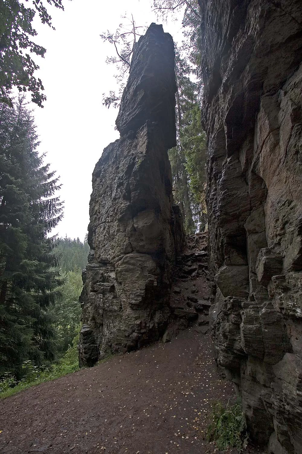
A vertical view of the tall gneiss rock formation at Rozštípená skála, showing a distinct split between two rock faces with a dirt path in the foreground.
The split rock formation at the Rozštípená skála natural monument.

Rozštípená skála history and protected-area timeline

Rozštípená skála was officially designated as a protected natural monument on 18 July 1974. The purpose of the designation was to preserve the rock formation itself, a gneiss cliff distinguished by a long weathered fissure that had given the site its descriptive name. The protected area has been administered through the Czech Agency for Nature Conservation and Landscape Protection, with on-the-ground management linked to the regional administration of the Žďárské vrchy Protected Landscape Area.

The site's broader context is tied to the Žďárské vrchy region, known for its highland scenery, rocky ridges, and traditional Bohemian-Moravian landscape culture. The placement of the site within that regional framework has shaped how the small monument has been protected and interpreted over the decades.

Rozštípená skála landscape and geographic character

The landscape around Rozštípená skála reflects the character of the Bohemian-Moravian Highlands: rolling forested hills, scattered rocky outcrops, and narrow river valleys. At the heart of the protected area stands a vertical gneiss rock face, roughly defined by a straight, wall-like appearance. The most striking landscape element is the deep, weathered fissure that opens the lower part of the cliff, creating an opening over ten meters long and around two meters wide.

Below the rock, the Sázava River flows through a small valley, crossed by a footbridge that connects hiking paths on either side. A meadow stretches at the foot of the cliff, softening the transition between hard rock geometry and the gentler, riverine ground nearby. The elevation of roughly 560 meters places the formation well within the typical mid-altitude range of the Žďárské vrchy region.
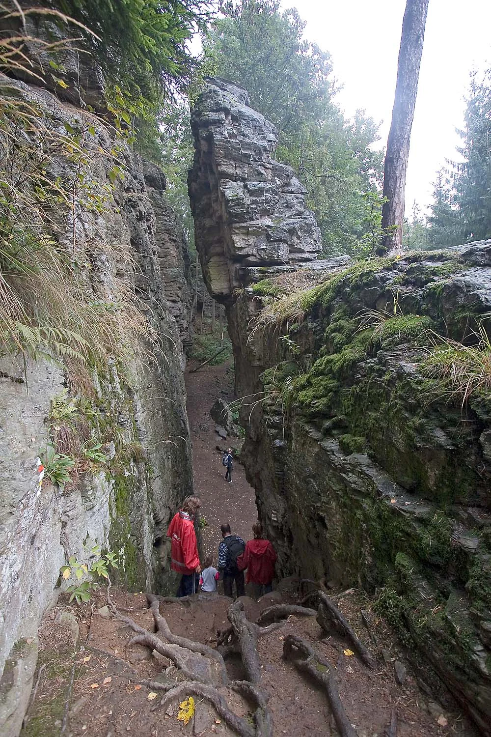
A group of hikers descends a narrow, earthy trail path between two high, vertical gneiss rock walls at Rozstipena skala.
Visitors walking through the narrow crevice of the Rozstipena skala natural monument.

Rozštípená skála ecosystems, habitats, and plant life

The natural value of Rozštípená skála is closely tied to its geological character rather than to expansive habitat zones. The site's most important ecological signal is its exposed gneiss rock face, which shelters crevice-dwelling plant communities typical of small rocky outcrops in the Žďárské vrchy.

Below the rock, a meadow and the riparian edge of the Sázava River add a contrasting softer habitat, supporting shallow-soil grassland species and, along the watercourse, typical river-valley vegetation. Together, the rock, meadow, and riverside create a compact mosaic of habitats that justifies the site's protection at the small-scale monument level.
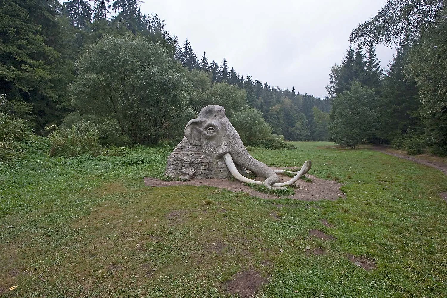
A large, realistic stone-like sculpture of a mammoth head emerging from the ground in a green grassy clearing surrounded by a dense conifer forest.
A sculpture of a mammoth head located in a clearing beneath the Rozštípená skála rock formation.

Rozštípená skála conservation status and protection priorities

The conservation significance of Rozštípená skála lies in its preservation of a distinctive geological formation: an exposed gneiss cliff with a characteristic weathered fissure. By protecting this small but visually unusual rock face, the designation helps maintain a representative example of the rocky landforms that occur throughout the Žďárské vrchy Protected Landscape Area.

The site also demonstrates the value of conserving small-scale natural monuments alongside larger landscape-level protections. Even at only 0.76 hectares, the area encapsulates geological, scenic, and micro-habitat values that contribute to the broader understanding and enjoyment of the Czech highland landscape.

Rozštípená skála cultural meaning and human context

The cultural dimension of Rozštípená skála is closely connected to the Žďárské vrchy region, a traditional part of the Bohemian-Moravian Highlands known for its folk heritage and its relationship with forested highland terrain. The nearby town of Žďár nad Sázavou adds a historical anchor to visitor experience, including the famous pilgrimage church complex that draws cultural tourists to the area.

Locally, the site also has a distinct artistic touch: a stone sculpture titled Hlava mamuta, created by regional sculptor Michal Olšiak, stands on the meadow beneath the rock. Roughly 2.5 meters tall, it depicts the head of a Pleistocene mammoth seemingly emerging from beneath the cliff, linking the geological monument with a creative visual interpretation of deep-time natural history.
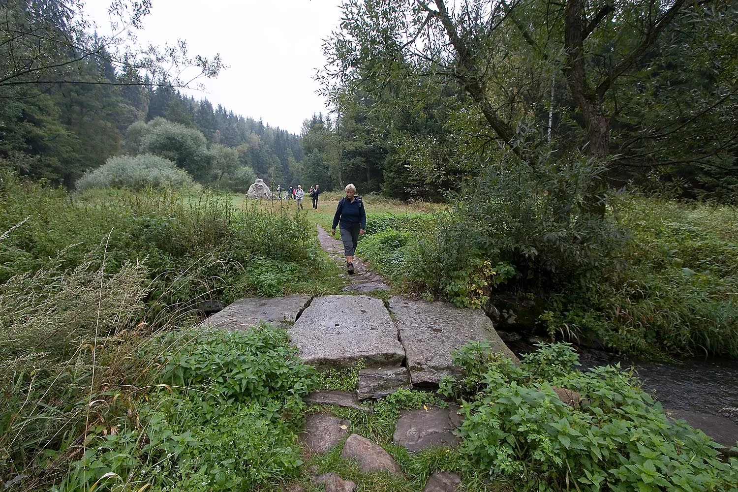
A hiker walking across a stone slab bridge over a small river in a forested landscape.
A hiker crosses a stone bridge over the Sázava River, with the landscape leading towards the forest.

Best time to visit Rozštípená skála

Rozštípená skála can be visited year-round, but late spring and early autumn are generally the most comfortable seasons for walking the marked trails leading to the rock, when the surrounding forest and meadow vegetation are fully visible and the Sázava River valley is scenically attractive. Summer offers green vegetation and easy trail conditions, while winter can give the rock a more dramatic appearance when snow emphasizes its split shape, though paths may be icy.

Monthly climate preview

Long-term monthly temperature and precipitation rhythm for Kraj Vysočina

Rozštípená skála Climate Normals and Measured Annual Temperature Patterns

Historical monitoring data from 1991 to 2000 establishes the recorded monthly temperature ranges and precipitation rates measured at representative elevations across Rozštípená skála. Reviewing the complete twelve-month profile provides deeper analytical context for long-term climate normals and seasonal variations.
Annual mean7 °C
-4 °C18 °C
Jan-4°
Feb-2°
Mar
Apr
May12°
Jun16°
Jul18°
Aug18°
Sep13°
Oct
Nov
Dec-2°
Warmest month
July

18.1 °C

Coolest month
January

-3.6 °C

Wettest month
July

2.9 mm/day

Driest month
February

1.3 mm/day

Park location guide

Geography guide, regional context, and park location map for Rozštípená skála

Rozštípená skála park geography, regions, and map view in Czechia

Understand where Rozštípená skála sits in Czechia through a broader geographic reading of the surrounding landscape, nearby location context, and its mapped position within the national park landscape.

How Rozštípená skála fits into Czechia

Czech Republic is a landlocked Central European country with a population of approximately 10.9 million people. The nation was established as an independent state on January 1, 1993, following the dissolution of Czechoslovakia. Its capital and largest city is Prague, with other major urban centers including Brno, Ostrava, Plzeň, and Liberec.

Wider geography shaping Rozštípená skála in Czechia

The Czech Republic is a landlocked country in Central Europe. It is bordered by Germany to the west, Austria to the south, Poland to the northeast, and Slovakia to the southeast. The landscape is predominantly hilly, with the territory covering 78,871 square kilometers.

Map view of Rozštípená skála

Use this park location map to pinpoint Rozštípená skála in Czechia, understand its exact geographic position, and read its mapped placement within the surrounding landscape more clearly.

Pigeon | © OpenStreetMap contributors

Location context for Rozštípená skála

Kraj Vysočina

Explore detailed imagery of the split rock formation, river valley, and protected terrain.

Rozštípená skála Photos and Scenery: Visualizing the Gneiss Cliff Landscape

Visual records capture the distinctive vertical gneiss cliff and weathered fissures that define the protected landscape around Rozštípená skála. Examining field photography reveals the rugged geological character, surrounding river valley, and regional terrain features more clearly.

A vertical view of the tall gneiss rock formation at Rozštípená skála, showing a distinct split between two rock faces with a dirt path in the foreground.

A narrow dirt trail winding between two massive, vertical gneiss rock walls surrounded by dense green forest foliage.

A group of hikers descends a narrow, earthy trail path between two high, vertical gneiss rock walls at Rozstipena skala.

A large, realistic stone-like sculpture of a mammoth head emerging from the ground in a green grassy clearing surrounded by a dense conifer forest.

A path leads along a tall, rugged, layered grey rock cliff on the right, with tall trees on the left side of the path.

A hiker walking across a stone slab bridge over a small river in a forested landscape.

Park atlas

Compare regional protected areas and discover related geological formations in the highlands

Exploring Parks Near Rozštípená Skála and Surrounding Protected Landscapes

Visitors exploring Rozštípená skála can continue browsing other protected areas and geological formations across the surrounding regional highlands. Comparing adjacent terrain features helps place local rock outcrops and river valleys into a broader geographical context.
A watercolor painting showing a soft landscape of rolling hills, grassy meadows, and patches of vegetation in a pastel color palette.
Natural monumentKraj Vysočina
About 9.8 km away#1 closest

Northeast

Sklenské louky Natural Monument: Wetland Landscapes in Kraj Vysočina

Highland geography and protected peatland habitats

Sklenské louky functions as a concentrated nature monument within the Kraj Vysočina region, preserving vital moisture-loving vegetation and peat-based ecosystems. The terrain features a characteristic mix of open meadows and spruce groupings, illustrating the diverse landscape character of the Bohemian-Moravian Highlands. This protected area provides a clear view into the region's unique upland hydrological and botanical patterns.

Area
0.063 km²
Established
1985
IUCN
IV
Relief
Upland
Watercolor painting of a rolling countryside scene featuring green hills, forest edges, and muted pastel tones on a white background.
Protected landscapeVysočina Region
About 10 km away#2 closest

South

Přírodní park Bohdalovsko: Protected Landscape and Wetland Geography in the Vysočina Region

Highland terrain, fishpond mosaics, and protected natural corridors.

Located in the Czech Republic, Přírodní park Bohdalovsko serves as a primary example of a cultural highland landscape. The area features a remarkable concentration of ponds and peatland pockets that anchor local biodiversity, including rare aquatic species and amphibian strongholds. Its geography is characterized by rolling uplands and varied forest-field mosaics that remain integral to the regional conservation framework of the Bohemian-Moravian Highlands.

Area
60.8 km²
Established
2001
Relief
Upland
Climate
Temperate
Natural monumentKraj Vysočina
About 16 km away#3 closest

East

Vávrova skála Natural Monument: Geological Exploration in the Kraj Vysočina Region

Metamorphic rock outcrops and highland protected habitats

Vávrova skála stands as a protected natural monument near Pohledec, showcasing a distinct orthogneiss formation shaped by Quaternary weathering. This site serves as a vital reference for the geological diversity of the Bohemian-Moravian highlands, protecting rare summit heath and dry grassland within the larger Žďárské vrchy protected landscape.

Area
0.001 km²
Established
1983
IUCN
III
Relief
Upland
A soft watercolor illustration of a landscape with rolling hills, a meandering stream, and wooded areas against a pale sky.
Natural monumentVysočina Region
About 17 km away#4 closest

Southeast

Rasuveň Natural Monument: Protected Forest Terrain in the Czech Vysočina Region

Mapping upland woodland and fir-beech conservation areas

Rasuveň protects a meaningful remnant of fir-beech forest in the Czech-Moravian Highlands. This natural monument, situated in the Vysočina Region, provides a quiet example of mature upland woodland conservation. Its geographic profile is defined by rolling ridges and crystalline bedrock, offering a dedicated space for observing natural forest structures within an increasingly managed agricultural landscape.

Area
0.207 km²
Established
1989
IUCN
IV
Relief
Upland
A horizontal watercolor painting depicting a soft, scenic view of hills with rocky outcrops in the foreground and a forested landscape in the distance.
Protected areaCzechia
About 17 km away#5 closest

Northeast

Malinská skála: Geomorphological Landmark and Viewpoint in the Czech-Moravian Highlands

Protected gneiss rock group and mountain ridge geography

Rising as a striking summit in the Žďárské vrchy, Malinská skála presents a concentrated group of named gneiss towers reaching 20 meters in height. The site functions as a geological monument, preserving classic examples of frost-shattered boulder streams and high-elevation landforms. With its panoramic vantage points, it serves as a central point for mapping the topography of the surrounding Czech upland ridges.

Area
0.058 km²
Established
1987
Relief
Mountain
Climate
Temperate
A soft watercolor painting showing a quiet pond landscape with grassy banks, reeds, and distant trees against a pale background.
Nature reservePardubický kraj
About 23 km away#6 closest

North

Ratajské rybníky Protected Nature Reserve: Highland Wetland Geography and Mapped Boundaries

A core wetland refuge for rare flora and fauna in the Pardubický kraj region

The Ratajské rybníky reserve represents a vital highland wetland ecosystem characterized by its three connected fishponds and surrounding quaking bogs. This mapped protected area provides an essential habitat for endangered butterfly populations, the rare moss Hamatocaulis vernicosus, and dense amphibian breeding grounds, set against the backdrop of the forested Železné hory mountain ridge.

Established
1990
IUCN
IV
Relief
Upland
Climate
Temperate
A soft watercolor illustration featuring rolling hills in pink and green tones with stylized coniferous trees, set against a white background.
Natural monumentPardubický kraj
About 23 km away#7 closest

Northeast

Rybenské Perničky: Natural Monument and Geological Landmark of the Bohemian-Moravian Highlands

Geological rock outcrops and protected upland terrain in the Pardubice Region

Investigate the geological structure of Rybenské Perničky, a protected natural monument featuring unique orthogneiss outcrops and characteristic bowl-shaped weathering basins. Situated in the Pardubice Region, this site offers a focused look at the crystalline rock formations and undulating plateau terrain of the Bohemian-Moravian Highlands, providing essential geographic context for this noteworthy natural landmark.

Area
0.141 km²
Established
1980
Relief
Upland
Climate
Temperate
A soft, horizontal watercolor painting showing a green meadow in the foreground leading to a line of trees and distant rolling hills.
Natural monumentKraj Vysočina
About 29 km away#8 closest

East

Na Ostrážné Natural Monument: Geographic Boundaries and Protected Meadow Landscapes

A vital Natura 2000 site in the Bohemian-Moravian Highlands

The Na Ostrážné natural monument encompasses a compact meadow ecosystem situated on an ecologically expressive slope. This area serves as a critical refuge for rare invertebrate species, maintaining traditional grassland characteristics within the Svratecká hornatina. Its status as both a national monument and a European site makes it a key focus for understanding habitat preservation in the Vysočina Region.

Area
0.014 km²
Established
2015
IUCN
IV
Relief
Upland

Common questions about visiting, size, designation, and location context for Rozštípená skála

Rozštípená skála FAQs for park facts, access, geography, and protected area context

Find quick answers about Rozštípená skála, including protected-area facts, park geography, trail and visitor context, and how the park fits into its surrounding country and regional landscape.
MoriAtlas Explorer

Continue Your Protected Areas Search Across the Global Atlas

Deepen your exploration by continuing the structured search for national parks and protected areas worldwide. Utilize the comprehensive filtering capabilities to compare different conservation landscapes and refine your understanding of global park geography. Discover more about the distribution and characteristics of protected natural areas.

Global natural geography