Mori Atlas logo
Nature reserveRüdesheimer Aue

Understanding the dynamic sediment, floodplain forests, and mapped river geography

Rüdesheimer Aue Nature Reserve: A Protected River Island in the Upper Rhine Landscape

Rüdesheimer Aue sits as a secluded river island within the Upper Rhine, forming part of the ecologically significant Inselrhein chain. This nature reserve provides a critical refuge for softwood floodplain forests and serves as a vital corridor for waterbirds moving along the river corridor. By mapping the shifting sandbanks and successional woodland, this site reveals the complex natural processes still shaping the Rhine valley environment within the Rheingau-Taunus-Kreis district.

river islandRhineUpper RhineInselrheinfloodplain forestAuwald

Rüdesheimer Aue

Nature reserve

Park overview

Structured park overview, official facts, and landscape profile for Rüdesheimer Aue

Rüdesheimer Aue park facts, protected area profile, and essential visitor context

Review the core facts for Rüdesheimer Aue, including designation, size, terrain, visitor scale, habitats, and operating context in one park-focused overview.

About Rüdesheimer Aue

Rüdesheimer Aue is one of the islands that make up the Inselrhein, the stretch of the Upper Rhine between Mainz and Bingen where the river historically spread across a broad floodplain and left behind a string of islands, gravel bars, and side channels. Today, the Rhine in this section is heavily engineered for navigation, but a few islands still survive, and Rüdesheimer Aue is among them. The island sits in the right-bank side of the river channel, close enough to the town of Rüdesheim am Rhein to be a familiar local landmark and yet isolated enough by water to remain ecologically distinct.

Although the island is only on the order of a few hectares in extent and reaches no more than the mid-eighties in elevation, it carries an ecological importance far out of proportion to its size. Its surface reflects the dynamic processes that built the Rhine floodplain: freshly accumulated sandbanks, layers of fine sediment and mud, and on top of them a cover of vegetation that has established itself through natural succession. Once these substrates would have supported extensive softwood floodplain forest; today, that habitat is among the rarest in Central Europe, and Rüdesheimer Aue preserves a recognizable fragment of it.

Modern protection reinforces this natural significance. The island is a designated Naturschutzgebiet, applying the strict German nature reserve regime, and it is also part of the European network of Habitats Directive sites as FFH-Gebiet 6013-350. This dual designation reflects both national and continental recognition of the island's value for threatened habitat types and species. In practical terms, the protection means the island is left to its own ecological dynamics, while human activity on the island itself is kept minimal; agriculture, building, and other interventions have been excluded in favor of allowing the habitat to develop.

Quick facts and research context for Rüdesheimer Aue

Rüdesheimer Aue is a river island in the Upper Rhine, located roughly 200 meters from the Rüdesheim shore above Rhine kilometer 526. The island belongs to the municipality of Rüdesheim am Rhein within the Rheingau-Taunus district and forms part of the Inselrhein, the system of Rhine islands running between Mainz and Bingen. The island covers a few hectares in area, sits between roughly 78 and 84 meters in elevation, and is uninhabited.

Its protected status is dual: it is designated as a Naturschutzgebiet under German nature conservation law and as an FFH-Gebiet under the European Union Habitats Directive. The composition of the island, fragments of softwood floodplain forest rooted on sandbanks and mudflats, supports habitat types that have become very rare along the Upper Rhine, and gives the site a recognized role in regional and continental conservation frameworks.

Protection and recognition

Documented terrestrial protection scope and official international designations

Rüdesheimer Aue Protection Status and Natura 2000 Recognition Details

Rüdesheimer Aue maintains a documented terrestrial protection scope backed by official Natura 2000 recognition records. Structured conservation data outlines the established management context and international designation details for this protected area.

International recognition

Protection details

Protection scope
Terrestrial
Transboundary protection
No
Park context

Deeper park guide and search-rich context for Rüdesheimer Aue

Rüdesheimer Aue history, landscape, wildlife, and travel context

Explore Rüdesheimer Aue through its history, landscape character, ecosystems, wildlife, conservation priorities, cultural context, and seasonal travel timing in a structured park guide built for atlas discovery and search intent.

Why Rüdesheimer Aue stands out

Rüdesheimer Aue is known above all for its function as a refuge of softwood floodplain forest along the Upper Rhine, an ecosystem that has been almost entirely cleared from the active floodplain over the past century. The combination of sandbanks, freshly deposited sediments, and naturally regenerated woodland makes the island a small but textbook example of an island in the so-called Inselrhein. Equally important is the island's role as a stepping stone for waterbirds. Its undisturbed shoreline habitats, sandbars, and sheltered interior provide resting, foraging, and wintering conditions for migratory and overwintering species. Together, these qualities; the surviving Auwald vegetation and the documented waterbird presence, define the island's conservation identity.
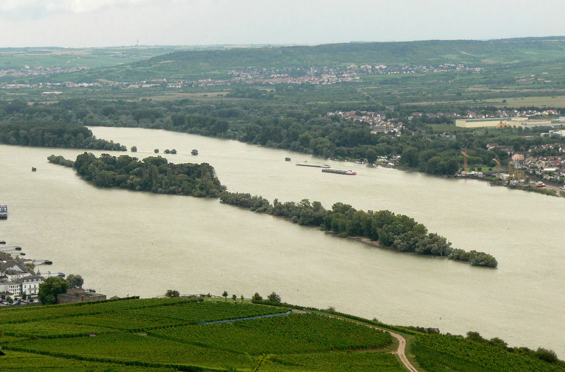
A wide, high angle view looking down at the forested Rüdesheimer Aue island situated in the middle of a wide river, with terraced vineyards in the foreground and a town on the far riverbank.
An aerial view of the Rüdesheimer Aue river island within the Rhine, observed from the surrounding hillside vineyards.

Rüdesheimer Aue history and protected-area timeline

The Rüdesheimer Aue has a modest but distinctive human history. In earlier centuries parts of the island were used for small-scale agriculture, with plots devoted to fruit and vegetable cultivation. That land-use phase is now over, and the island has returned to a fully natural cover of shrubs and trees driven by ecological succession rather than by farming or forestry.

A more visible trace of the island's past sits at its upper tip, where a single pillar of the former Hindenburgbrücke once stood. The Hindenburg Bridge was a significant Rhine crossing at this location; its surviving pillar on the island serves as a reminder that the Rüdesheimer Aue was tied into the broader infrastructure and traffic history of the Middle Rhine, before the bridge itself was dismantled and replaced. That solitary pillar is a notable cultural landmark on what is otherwise an entirely nature-driven island.

Rüdesheimer Aue landscape and geographic character

Rüdesheimer Aue is a low-lying river island shaped entirely by the dynamics of the Upper Rhine. It rises only to between about 78 and 84 meters in elevation, with a mean height around 81 meters, and runs roughly 900 meters in length while remaining quite narrow at around 120 meters across. The island's edges are defined by sandbanks and silty mudflats, where active river processes continue to deposit and rework material, gradually extending the island's footprint.

Along these margins, the natural engineering of the Rhine plays a quiet role: longitudinal training works, so-called Längswerke, anchor the upper and lower ends of the island, and the gentle sediment build-up behind them has lengthened the island over time. Together, the open sediment surfaces and the wooded interior create a layered landscape, moving from bare or sparsely vegetated shoreline through young successional woodland, and that gradient is itself part of what makes the island ecologically valuable.

Rüdesheimer Aue ecosystems, habitats, and plant life

The natural character of Rüdesheimer Aue is built on three closely linked elements: the surviving floodplain forest fragments, the open sandbanks, and the mudflats along the river's edge. Together they form a miniature version of the Auwald landscape that once stretched along much of the Upper Rhine and which has since been largely lost. The island's vegetation has been allowed to develop through natural succession, and it is now completely covered with shrubs and trees, a cover that reflects the resilience of floodplain woodland once it is given the chance to establish.

The mix of habitats matters because it provides niches for very different kinds of life. Open sediment areas favor pioneer plants and invertebrates adapted to disturbance and seasonal flooding; the softwood forest above brings typical floodplain tree species, including willows and poplars historically associated with this environment. Although the island is small, the combination of these habitats in close proximity gives Rüdesheimer Aue a habitat diversity that is unusual for such a compact protected area along this stretch of the Rhine.

Rüdesheimer Aue wildlife and species highlights

The island is documented as a breeding site for Black Kite and Northern Lapwing, both species that depend on undisturbed riverine habitats with a mix of open ground and adjacent woodland. This breeding presence alone makes the island notable in a regional context, as both species have become restricted in their distribution along the heavily modified Upper Rhine.

Beyond the breeding season, the island functions as a resting and wintering site for an exceptional list of waterbirds. Recorded visitors include Common Kingfisher, Whooper Swan, Smew, Osprey, Ruff, Eurasian Teal, Greylag Goose, Bean Goose, Common Pochard, Tufted Duck, Greater White-fronted Goose, Common Goldeneye, Goosander, Red-breasted Merganser, and Common Redshank. The recurring presence of these species highlights the island's role as a stepping stone in the broader flyway along the Rhine and gives Rüdesheimer Aue an importance that extends well beyond its local catchment.

Rüdesheimer Aue conservation status and protection priorities

Rüdesheimer Aue matters from a conservation perspective because it preserves habitat types and species assemblages that have been almost lost from the Upper Rhine. Softwood floodplain forest, the Auwald, was once a defining feature of this river system, but the vast majority has been cleared over the past century for agriculture, settlements, flood control, and shipping. The island's surviving fragments, combined with its open sandbanks and mudflats, give it an outsized role in maintaining the ecological memory of the original floodplain.

Reflecting this importance, the island carries two overlapping protective designations. As a Naturschutzgebiet, it falls under Germany's strictest category of domestic nature reserve, restricting uses that could alter the habitat. As FFH-Gebiet 6013-350, it is integrated into the European Union's Natura 2000 network under the Habitats Directive, which commits it to a broader transnational framework of habitat and species protection. The combination of these instruments means that Rüdesheimer Aue is monitored and managed not only as a local natural asset but as part of the continent's effort to sustain its remaining floodplain biodiversity.

Rüdesheimer Aue cultural meaning and human context

Beyond its ecological profile, the island carries a small but tangible cultural footprint. The surviving bridge pillar of the former Hindenburgbrücke at the upper end of the island, a relic of the once major Rhine crossing near Rüdesheim, anchors the island in the transport history of the Middle Rhine. The shift from agricultural use to fully natural succession also tells a quieter story: a working agrarian plot gradually absorbed back into the landscape as protection took hold. Together, these traces connect the island to the broader human history of the Rheingau region without overshadowing its present-day role as a protected natural site.

Top sights and standout views in Rüdesheimer Aue

Rüdesheimer Aue stands out for the combination of a rare surviving softwood floodplain forest cover on a small, dynamic Rhine island, dual protection under both German Naturschutzgebiet and EU Habitats Directive law, and a well-documented function as a stepping stone for waterbirds along the Rhine. The island's mix of sandbanks, mudflats, and successional woodland, together with the visible remains of the Hindenburgbrücke pillar, gives it both an ecological and a modest cultural signature that is rare for a site of its proportions.

Best time to visit Rüdesheimer Aue

As a protected, uninhabited island, Rüdesheimer Aue is not set up for casual visits. Its value is best appreciated from viewpoints on the surrounding hills and vineyards, such as the Rochusberg or Rüdesheimer Berg, which overlook the island against the wider backdrop of the Rhine valley. For those interested in waterbirds, cooler months tend to bring the most diverse mix of resting and wintering species; for floodplain woodland character, late spring through early autumn shows the island at its most vegetatively expressive, when the succession cover is fully leafed out against the river.


Monthly climate preview

Long-term monthly temperature and precipitation data for Rüdesheimer Aue

Rüdesheimer Aue Climate Normals and Measured Temperature Rhythm

Historical climate records for Rüdesheimer Aue outline a measured annual temperature and precipitation rhythm across the representative coordinate. Reviewing the complete twelve-month profile provides detailed meteorological context for studying long-term environmental patterns in this protected landscape.
Annual mean9 °C
0 °C20 °C
Jan
Feb
Mar
Apr
May13°
Jun17°
Jul20°
Aug19°
Sep15°
Oct
Nov
Dec
Warmest month
July

19.6 °C

Coolest month
January

-0.1 °C

Wettest month
July

2.2 mm/day

Driest month
April

1.5 mm/day

Park location guide

Geography guide, regional context, and park location map for Rüdesheimer Aue

Rüdesheimer Aue park geography, regions, and map view in Germany

Understand where Rüdesheimer Aue sits in Germany through a broader geographic reading of the surrounding landscape, nearby location context, and its mapped position within the national park landscape.

How Rüdesheimer Aue fits into Germany

Germany is a federal republic in Western and Central Europe with a population of over 83 million across sixteen constituent states. It is Europe's largest economy by nominal GDP and a major global exporter and importer. The capital is Berlin, and the country borders Denmark, Poland, Czech Republic, Austria, Switzerland, France, Luxembourg, Belgium, and the Netherlands.

Wider geography shaping Rüdesheimer Aue in Germany

Germany is located in Western and Central Europe, spanning 357,022 km². It borders Denmark to the north, Poland and the Czech Republic to the east, Austria and Switzerland to the south, and France, Luxembourg, Belgium, and the Netherlands to the west. The country has coastlines on the Baltic Sea and North Sea to the north, with the Alps located in the southern region.

Map view of Rüdesheimer Aue

Use this park location map to pinpoint Rüdesheimer Aue in Germany, understand its exact geographic position, and read its mapped placement within the surrounding landscape more clearly.

Pigeon | © OpenStreetMap contributors

Location context for Rüdesheimer Aue

Rheingau-Taunus-Kreis
Recorded earthquake history

Examine the Documented Earthquake History for Rüdesheimer Aue

Review a comprehensive collection of recorded seismic events associated with the geography of Rüdesheimer Aue. This MoriAtlas catalogue provides historical data on regional earthquakes, allowing users to map and compare event details based on their proximity to this protected river island.

Rüdesheimer Aue Earthquake History

Catalogued events

34 events

Strongest magnitude

Magnitude 4.3

Most recent event

Feb 14, 2011

This history includes earthquakes recorded inside the park or within 50 km of its borders

Floodplain woodland, sandbanks, and river-island change in visual detail

Rüdesheimer Aue landscape images of an Upper Rhine island reserve

Explore Rüdesheimer Aue through photographs that place its secluded river-island form within the Upper Rhine and wider Inselrhein chain. Views of floodplain woodland, shore margins, and shifting sandbanks make the reserve's successional landscape and role in the Rhine corridor easier to read.

A wide, high angle view looking down at the forested Rüdesheimer Aue island situated in the middle of a wide river, with terraced vineyards in the foreground and a town on the far riverbank.

A high vantage point view of Rüdesheimer Aue, a forested river island in the Rhine, with urban development on the riverbanks.

Park atlas

Discover related protected landscapes and river valley reserves across the surrounding regional geography

Exploring Other Parks and Protected Areas Near Rüdesheimer Aue

Continue browsing other parks near Rüdesheimer Aue to compare similar floodplain ecosystems and protected river habitats along the Rhine corridor. Examining adjacent conservation areas provides valuable context on regional wildlife corridors and dynamic wetland terrain.
A watercolor painting showing a soft, atmospheric landscape with a river flowing through green hills and gentle, misty mountains.
Nature reserveRhineland-Palatinate
Park boundaries overlap#1 closest

East

Inselrhein Nature Reserve, Rhineland-Palatinate: A Geographic and Protected-Area Atlas

River islands, floodplain forests, and Upper Rhine wetlands

Inselrhein features a chain of natural river islands and side channels forming a critical wetland habitat. The terrain transition from soft-wood to hardwood forest communities creates a layered landscape. Examine the protected boundaries and geographic significance of this river corridor between Mainz and Bingen, documented within the Rhineland-Palatinate atlas.

Relief
Lowland
Climate
Temperate
Access
Easy access
Scope
Terrestrial
A watercolor illustration of a calm body of water with a single tree in the center; distant rolling hills are visible in the background under a soft, pastel-colored sky.
Nature reserveLower Saxony
About 1.7 km away#2 closest

East

Fulder Aue, Ilmen Aue Nature Reserve: Mapped Protected Landscapes and Floodplain Geography

Alluvial river islands and wetland ecosystems in the Rhine valley.

The Fulder Aue, Ilmen Aue nature reserve serves as an vital example of an active Rhine floodplain. This area preserves a mosaic of islands, connecting channels, and soft-wood forest habitats. Learn about the geographic and hydrological dynamics that shape this protected space near Bingen am Rhein, showcasing its importance within the Rhine lowland system.

Area
3.38 km²
Established
1995
Relief
Lowland
Scope
Terrestrial
A horizontal watercolor painting showing a serene valley landscape with distant rolling mountains, a central winding river or stream, and grassy banks in soft muted colors.
Nature reserveGermany
About 6.1 km away#3 closest

West

Morgenbachtal Nature Reserve: A Geographic Atlas of the Middle Rhine Slate Cliffs

Exploration of the Binger Wald protected valley and its geological terrain.

Morgenbachtal presents a unique geographic profile characterized by two distinct ridge lines of crystalline slate cliffs. This protected area in Germany balances strict conservation with a complex landscape of narrow ravines, mixed forests, and historical landmarks like the Steckeschlääferklamm gorge and medieval castle ruins along the Rhine.

A horizontal watercolor painting of a river landscape with lush green trees, grasses, and a winding waterway under a soft light.
Nature reserveHessen
7.6 km away#4 closest

East

Mariannenaue Nature Reserve: Protected River Island Geography and Landscape Atlas

Rhine river island and floodplain forest in Hessen, Germany.

Mariannenaue serves as a prominent example of a protected inland island in the Upper Rhine. Its geography encompasses a complex mix of veteran floodplain forest, still-water habitats, and centuries-old vineyard cultivation. This detail page provides insights into the park boundaries, the surrounding riverine terrain, and the ecological network that connects this site to the broader Rheingau landscape.

Area
1.96 km²
Established
1972
Relief
Lowland
Climate
Temperate
A horizontal watercolor painting showing a river winding through lush green islands and low hills in the background.
Nature reserveHesse
9 km away#5 closest

Northwest

Lorcher Werth Nature Reserve: Protected Rhine Island Geography and Floodplain Forest

An ecologically significant island pair in the Middle Rhine, Hesse.

Lorcher Werth is a unique river island complex in Hesse, Germany, designated as a nature reserve and European Habitats Directive site. These uninhabited islands act as a vital refuge for floodplain habitats, currently undergoing a transformation toward natural Auwald forest. This site provides a rare, flat fluvial counterpoint to the surrounding steep and narrow landscapes of the Middle Rhine corridor.

Area
0.129 km²
Relief
Lowland
Climate
Temperate
Access
Highly restricted
Nature reserveRhineland-Palatinate
About 11 km away#6 closest

East

Hangflächen um den Heidesheimer Weg: Nature Reserve Geography and Protected Landscape Context

Mainz-Bingen, Rhineland-Palatinate Nature Reserve

Hangflächen um den Heidesheimer Weg contains an unusual ecological convergence of sand dunes, open flats, and calcareous grasslands near Ingelheim am Rhein. This nature reserve provides critical protection for a fragmented yet highly structured landscape where springs and wetland zones intersect with warm, dry slopes. The area preserves a significant biotope complex of national importance within the Upper Rhine Plain.

Area
3.348 km²
Established
2003
A horizontal watercolor illustration of a natural landscape featuring a small body of water or pond in the foreground, surrounded by grassy banks, low hills in the distance, and soft-colored vegetation.
Nature reserveRhineland-Palatinate
About 11 km away#7 closest

East

Sandgrube am Weilersberg Nature Reserve and Protected Landscape Map

Rhineland-Palatinate, Germany protected area

Sandgrube am Weilersberg is a protected nature reserve in Rhineland-Palatinate, Germany, known for its compact mosaic of calcareous sand slopes and wet meadows. Part of the Natura 2000 network, the site preserves rare steppe flora and wetland ecosystems that emerged following former sand extraction. The terrain supports significant entomological, botanical, and bryological diversity maintained through active grazing.

Area
0.095 km²
Established
1986
Relief
Lowland
Climate
Temperate
Nature reserveRhineland-Palatinate
About 16 km away#8 closest

East

Wiesen am Layenhof, Ober-Olmer Wald Nature Reserve: Mapped Landscapes of Rhineland-Palatinate

Protecting a delicate balance of beech woodland and rare dry grassland ecosystems.

Spanning 533 hectares near Mainz, this nature reserve serves as a critical refuge for biodiversity, characterized by its interlocking habitat types including oak-beech forests and orchid-rich dry swards. The geography is shaped by small seasonal pools and a network of pathways that provide access to the protected terrain, offering a clear view of how woodland and meadow habitats interact within the landscape of Rhineland-Palatinate.

Area
5.33 km²
Established
2017
Relief
Lowland
Scope
Terrestrial

Common questions about visiting, size, designation, and location context for Rüdesheimer Aue

Rüdesheimer Aue FAQs for park facts, access, geography, and protected area context

Find quick answers about Rüdesheimer Aue, including protected-area facts, park geography, trail and visitor context, and how the park fits into its surrounding country and regional landscape.
MoriAtlas Explorer

Continue Your Protected Areas Search Across the Global Atlas

Deepen your exploration by continuing the structured search for national parks and protected areas worldwide. Utilize the comprehensive filtering capabilities to compare different conservation landscapes and refine your understanding of global park geography. Discover more about the distribution and characteristics of protected natural areas.

Global natural geography