
Mori Atlas logo
Nature reserveRuggeller Riet

A rare glacial-basin habitat protecting peat meadows and moorland within the Alpine Rhine valley floor.

Ruggeller Riet Nature Reserve: Mapping the Protected Wetland Landscapes of Northern Liechtenstein

(Ruggeller Riet Nature Reserve)

Ruggeller Riet represents a significant nature reserve situated in the northernmost municipality of Liechtenstein. This protected landscape occupies a glacial basin along the Alpine Rhine valley floor, preserving a unique ecosystem of wet meadows and peat-rich moorland. As an internationally recognized wetland site, the area serves as a critical corridor for migratory birds and provides a distinct contrast to the surrounding mountainous terrain of the region.

wetland nature reserveRamsar sitepeat meadowsmoorlandImportant Bird AreaAlpine Rhine valley
Stylized vector illustration of a mountainous landscape featuring a waterfall cascading between peaks, surrounded by pine trees and soft-colored slopes.

Ruggeller Riet

Nature reserve

Park overview

Structured park overview, official facts, and landscape profile for Ruggeller Riet

Ruggeller Riet park facts, protected area profile, and essential visitor context

Review the core facts for Ruggeller Riet, including designation, size, terrain, visitor scale, habitats, and operating context in one park-focused overview.

About Ruggeller Riet

Ruggeller Riet Nature Reserve is the most important wetland protected area in Liechtenstein, situated in the far north of the principality in the valley of the Alpine Rhine. Although Liechtenstein is usually associated with alpine scenery, Ruggeller Riet represents the country's lowland face: a flat, peat-rich wetland landscape at around 430 metres above sea level, framed by the broad floodplain of the Rhine.

The reserve covers roughly 88 hectares near the eastern bank of the Alpine Rhine, close to the tripoint where Liechtenstein, Austria, and Switzerland meet. This location anchors the site regionally within a larger transboundary wetland system shaped by the geomorphology of the Rhine valley.

Ecologically, Ruggeller Riet is dominated by wet meadows, bogs, and moorland communities established on a deep bed of peat. The vegetation reflects the site's long history as a wetland, dominated by purple moor grass, brown bog-rush, and great fen-sedge, with other characteristic species such as crested wood fern, gladiolus, and Siberian iris also present. Together they form a distinctive lowland fen habitat that contrasts with the surrounding cultivated valley floor.

The reserve is nationally protected under IUCN category Ia as a strict nature reserve, and internationally recognized through its designation as a Ramsar Wetland in 1991 and as a BirdLife International Important Bird Area. Even though it is a small site by international standards, Ruggeller Riet provides disproportionate value for bird conservation in the Alpine Rhine region, supporting breeding corn crakes and common quails, as well as wintering hen harriers and passage marsh harriers.

Quick facts and research context for Ruggeller Riet

Ruggeller Riet is a wetland nature reserve located in Ruggell municipality in northern Liechtenstein, near the tripoint with Austria and Switzerland. It encompasses about 88 hectares of wet meadows and moorland in the Alpine Rhine valley at roughly 430 metres above sea level. The reserve has been a national nature reserve since 1978 and is Liechtenstein's first and only Ramsar site, designated on 6 August 1991. It is also recognized by BirdLife International as an Important Bird Area because of its importance for breeding, passage, and wintering birds.

Protection and recognition

Documented conservation status and Ramsar wetland recognition details

Ruggeller Riet Protection Status and International Recognition Data

Ruggeller Riet maintains documented international recognition through official Ramsar wetland listings. Official records detail the protected area designation and international conservation status without assuming management outcomes.
Park context

Deeper park guide and search-rich context for Ruggeller Riet

Ruggeller Riet history, landscape, wildlife, and travel context

Explore Ruggeller Riet through its history, landscape character, ecosystems, wildlife, conservation priorities, cultural context, and seasonal travel timing in a structured park guide built for atlas discovery and search intent.

Why Ruggeller Riet stands out

Ruggeller Riet is best known for being Liechtenstein's sole Ramsar wetland and one of the country's most valuable lowland nature reserves. Its peat meadows and moorland support a distinctive community of sedges, moor grasses, and flowering wetland plants, while serving as an important stopover and breeding habitat for migratory and grassland birds. The reserve is recognized as an Important Bird Area for species such as corn crake, common quail, whinchat, red-backed shrike, hen harrier, and several marsh harriers, giving the site a significance that extends well beyond its modest size.
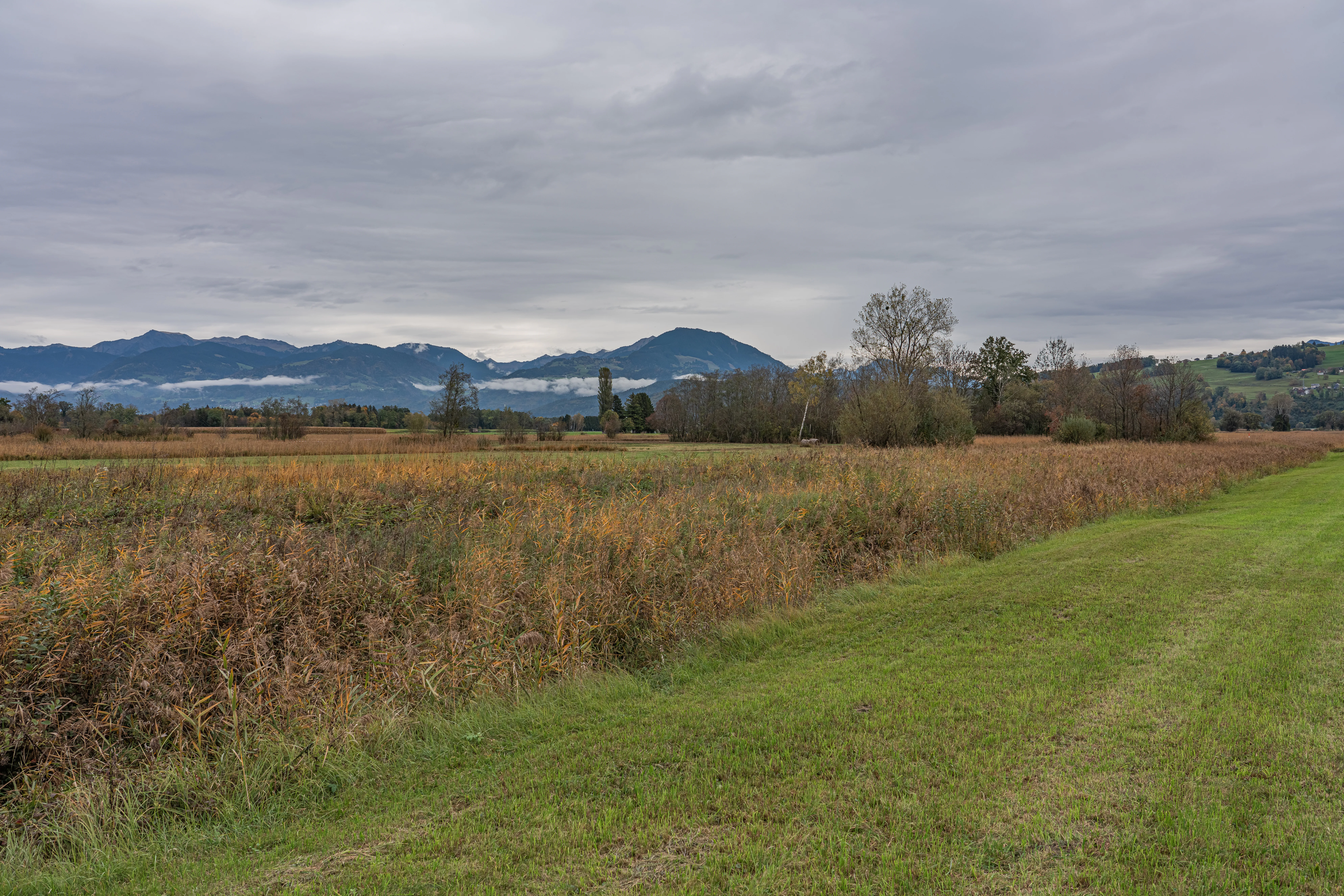
A wide view of a flat moorland landscape with brown marsh grasses and green meadow fields, backed by a distant mountain range under a cloudy sky.
The moorland landscape of Ruggeller Riet in Liechtenstein, characterized by expansive wet meadows and distant mountain views.

Ruggeller Riet history and protected-area timeline

The wetland landscape of Ruggeller Riet has roots that reach back to the end of the last ice age. After the Rhine Glacier retreated from the valley around 16,500 years ago, the area was left with shallow meltwater lakes. Over millennia, silt carried by the Rhine gradually filled these basins, creating bogs and laying down the peat deposits that still underpin the reserve today.

Evidence of human presence in the area dates back as far as the 4th millennium BCE, recorded in pollen profiles from the peat. Bronze Age and Iron Age artifacts have also been recovered from the bog, indicating that the wetland was part of human environments for thousands of years.

The name "Ruggeller Riet" is itself thought to refer to reeds that once spread across the region before intensive agriculture reshaped the valley. Since the late Middle Ages, the meadows have been used by local farmers for pasture and hay-making, a traditional low-intensity land use that helped preserve the open character of the wetland. In the nineteenth century a small-scale peat-cutting industry developed, but it declined after World War II as the modern agricultural economy shifted away from the bog.

The site entered formal conservation in 1978, when the Principality of Liechtenstein designated Ruggeller Riet as a national nature reserve. In 1991, when Liechtenstein acceded to the Ramsar Convention, Ruggeller Riet became the country's first and only Ramsar site, placing it on the international map of wetlands of importance.

Ruggeller Riet landscape and geographic character

Ruggeller Riet sits on the floor of the Alpine Rhine valley, in the lowest and most northerly part of Liechtenstein. Its elevation, around 430 metres above sea level, is modest by Liechtenstein standards and gives the reserve a very different character from the steep alpine terrain that dominates the rest of the country.

The physical setting is shaped by the post-glacial history of the Rhine valley. Ancient meltwater basins filled with silt and organic material left a thick layer of peat, on which the present-day wet meadows and moorland are established. The result is a relatively flat, open landscape of damp grassland, boggy hollows, and peatland vegetation, bordered by the broader floodplain of the Alpine Rhine.

The reserve lies near the east bank of the Rhine, close to the tripoint with Austria and Switzerland. This geographic position embeds Ruggeller Riet within a wider corridor of lowland habitats along the river, making the landscape both locally protected and part of a larger valley-scale ecosystem.

Ruggeller Riet ecosystems, habitats, and plant life

Ruggeller Riet preserves a complex of wet meadows and moorland that has developed on peat laid down in the former glacial lake basin of the Alpine Rhine. The habitat mosaic reflects the long ecological history of the site, where silt deposition and peat formation have produced the conditions for a distinctive lowland wetland community.

The vegetation is dominated by species typical of fen meadows and bog margins. Purple moor grass is one of the most conspicuous plants, joined by brown bog-rush and great fen-sedge in forming the structural backbone of the meadows. Other characteristic species include crested wood fern, gladiolus, and Siberian iris, contributing to the diversity and seasonal color of the reserve.

Because of its open, waterlogged character and its position in the Rhine valley, Ruggeller Riet provides a rare low-elevation wetland habitat in a small country that is otherwise dominated by alpine environments. This ecological setting supports a wide array of invertebrates, which in turn underpins the reserve's importance for birds.

Ruggeller Riet wildlife and species highlights

The wetland habitat of Ruggeller Riet makes it a particularly significant site for birds in Liechtenstein. The reserve functions both as a breeding area for ground-nesting and meadow species, and as a stopover for migratory birds moving along the Rhine valley.

BirdLife International has recognized Ruggeller Riet as an Important Bird Area because of this birdlife. The reserve supports breeding populations of corn crakes and common quails in its grassy meadows, along with whinchats and red-backed shrikes, both of which favor open habitats with scattered shrubs and perches. In winter the site hosts hen harriers, while both western marsh harriers and Montagu's harriers pass through on migration, taking advantage of the rich hunting grounds provided by the open wetland landscape.

Storks have also been documented using the area as a stopover, underscoring the reserve's role as a refuge along broader flyways rather than just a small local wetland.

Ruggeller Riet conservation status and protection priorities

Ruggeller Riet holds a notably strong conservation status for a reserve of its size. Domestically, it has been protected as a national nature reserve by the Principality of Liechtenstein since 1978, classified under IUCN category Ia as a strict nature reserve. This places it in the highest tier of protection, with management oriented toward preserving natural processes rather than accommodating heavy public use.

Internationally, the reserve's significance was cemented in 1991 when it was designated as Liechtenstein's first and only Ramsar site, on the day Liechtenstein acceded to the Ramsar Convention. The Ramsar listing recognizes the wetland as being of international importance for its ecological character, its hydrological functions, and its biodiversity.

The BirdLife International Important Bird Area designation adds another layer of international recognition. By supporting breeding corn crakes, common quails, whinchats, and red-backed shrikes, and by serving wintering and passage habitat for hen harrier, western marsh harrier, and Montagu's harrier, the reserve contributes to broader conservation efforts for grassland and wetland bird species across the Alpine Rhine region.

Ruggeller Riet cultural meaning and human context

The landscape of Ruggeller Riet has been part of the agricultural life of northern Liechtenstein for centuries. The name itself, derived from reeds that once clothed the valley floor, preserves an older ecological memory embedded in local language. Since the late Middle Ages, the meadows have been managed as pasture and hay fields, an association between the wetland and traditional farming that helped shape both the vegetation and the cultural identity of the Ruggell area.

The preservation of the reserve can also be read as part of the wider recognition, late in the twentieth century, of the cultural and historical value of these working landscapes, even as peat-cutting and traditional land uses declined in the modern era.

Top sights and standout views in Ruggeller Riet

Ruggeller Riet stands out as Liechtenstein's most significant lowland protected area and as a rare example of an internationally important wetland in a predominantly alpine country. Its peat-rich wet meadows, dominated by purple moor grass, brown bog-rush, and great fen-sedge, support Siberian iris and gladiolus, creating a distinctive habitat that is unique within the country.

The reserve combines national, Ramsar, and BirdLife International recognition, making it a focal point for conservation in the Alpine Rhine valley. Its role as breeding habitat for corn crakes and common quails, its importance for whinchats and red-backed shrikes, and its value for wintering and migrating harriers all combine to give this small reserve an ecological footprint far larger than its 88 hectares might suggest.

Best time to visit Ruggeller Riet

Ruggeller Riet is best appreciated in late spring and summer, when the wet meadows are most visually active and flowering species such as gladiolus and Siberian iris contribute to the seasonal character of the vegetation. This is also the period when breeding birds such as corn crakes, common quails, whinchats, and red-backed shrikes are most easily associated with the meadows.

Autumn and winter bring quieter conditions and the possibility of observing wintering hen harriers over the open landscape. Migratory passage, including storks and marsh harriers, can add further seasonal interest to a visit, while the broad, flat valley setting makes the reserve accessible from Ruggell throughout much of the year. As a strict nature reserve, visits are primarily oriented around observation from the perimeter and appreciation of the landscape rather than active recreation within the protected area itself.

Monthly climate preview

Track representative monthly averages and multi-year climate patterns across Ruggeller Riet.

Ruggeller Riet Climate Normals, Long Term Temperature and Precipitation Rhythm

Long-term NASA measurements reveal a measured annual rhythm of shifting temperatures and precipitation across Ruggeller Riet from 1991 to 2020. Examining the complete twelve-month climate profile provides deeper context for monthly averages and multi-year meteorological trends.
Annual mean8 °C
-1 °C18 °C
Jan-1°
Feb-1°
Mar
Apr
May12°
Jun16°
Jul18°
Aug18°
Sep13°
Oct
Nov
Dec
Warmest month
July

17.9 °C

Coolest month
January

-1.3 °C

Wettest month
June

5.1 mm/day

Driest month
February

2.8 mm/day

Park location guide

Geography guide, regional context, and park location map for Ruggeller Riet

Ruggeller Riet park geography, regions, and map view in Liechtenstein

Understand where Ruggeller Riet sits in Liechtenstein through a broader geographic reading of the surrounding landscape, nearby location context, and its mapped position within the national park landscape.

How Ruggeller Riet fits into Liechtenstein

The Principality of Liechtenstein is a small Central European country in the Alps, bordered by Switzerland to the west and north and Austria to the east. Founded in 1719, it became fully independent in 1866. The country is a parliamentary monarchy with the Prince holding significant executive powers. With an area of just 160 km² and a population of around 41,000, it is one of Europe's smallest and wealthiest nations.

Wider geography shaping Ruggeller Riet in Liechtenstein

Liechtenstein is situated in the Central European Alps between Austria to the east and north-east and Switzerland to the north-west, west and south. The country is doubly landlocked, meaning it is landlocked and surrounded by other landlocked countries. The terrain is mountainous with the Rhine River forming part of its western border.

Map view of Ruggeller Riet

Use this park location map to pinpoint Ruggeller Riet in Liechtenstein, understand its exact geographic position, and read its mapped placement within the surrounding landscape more clearly.

Pigeon | © OpenStreetMap contributors
Recorded earthquake history

Examine Recorded Earthquake History Near Ruggeller Riet Nature Reserve

Consult the historical catalogue of seismic activity associated with the Ruggeller Riet wetland. Discover mapped records of nearby events, including magnitude and distance data, to better understand the seismic history of this protected landscape in the Alpine Rhine valley.

Ruggeller Riet Earthquake History

Catalogued events

88 events

Strongest magnitude

Magnitude 5.2

Most recent event

Apr 26, 2026

This history includes earthquakes recorded inside the park or within 50 km of its borders

Visual exploration of Liechtenstein's lowland peat meadows and Ramsar wetland scenery

Ruggeller Riet Photos: Scenery, Wetland Landscapes, and Protected Habitats

Visual documentation captures the flat terrain and peatland vegetation characterizing Ruggeller Riet within the Alpine Rhine valley. Examination of field photographs reveals the distinctive ecological composition of wet meadows, sedge communities, and protected bird habitats.

A wide view of a flat moorland landscape with brown marsh grasses and green meadow fields, backed by a distant mountain range under a cloudy sky.

Park atlas

Compare nearby lowland reserves, valley wetlands, and regional conservation landscapes

Parks Near Ruggeller Riet and Connected Protected Areas in the Alpine Rhine Valley

Continue exploring protected areas near Ruggeller Riet by comparing adjacent lowland wetlands and valley habitats across the surrounding region. Examining connected conservation landscapes provides deeper context on regional geography and post-glacial ecosystems.
Light watercolor illustration of a winding river or lake curving through green trees and vegetation with pale mountains in the distant background
Nature reserveLiechtenstein
About 4.2 km away#1 closest

Southwest

Gampriner Seelein Nature Reserve: Geographical Context and Mapped Protected Boundaries

A rare natural lake within the Rhine Valley lowlands

Gampriner Seelein serves as a vital nature reserve and the sole naturally formed lake in Liechtenstein. Formed by historic Rhine flood events, this site preserves a rare floodplain forest ecosystem and managed wetland, providing essential habitat for diverse aquatic species and birds within a densely developed regional geography.

Area
0.015 km²
Established
1961
Relief
Lowland
Climate
Temperate
A wide watercolor illustration showing a landscape of green fields, trees, small white buildings, and distant purple mountains.
Biosphere reserveVorarlberg
About 13 km away#2 closest

South

Biosphere Reserve Großes Walsertal: Regional Geography and Protected Alpine Landscapes

A mapped conservation zone within the Vorarlberg Alps

Biosphere Reserve Großes Walsertal encompasses a protected valley characterized by significant geological diversity. Explore the transition from the soft flysch ridges of the Walserkamm to the dramatic limestone crests of the Kalkhochalpen, reflecting a modern approach to managing Alpine natural resources and cultural heritage in western Austria.

Area
192.31 km²
Established
2000
A watercolor painting showing a panoramic view of a wetland with water, grasses in the foreground, green hills, and purple-toned mountains in the distance.
Nature reserveVorarlberg
About 28 km away#3 closest

North

Rhine Delta Nature Reserve: Mapped Wetlands and Alpine Foothills Geography in Vorarlberg

A dynamic freshwater delta and critical bird habitat in Austria

The Rhine Delta constitutes the largest wetland biotope on Lake Constance, characterized by ongoing sediment deposits and an evolving shoreline. Its geography includes dense riparian forests, alluvial plains, and shallow bays that provide refuge for diverse amphibians and birds. This nature reserve serves as a prime example of large-scale wetland conservation nestled between the Alpine foothills and the open waters of the lake.

Area
20.65 km²
Established
1982
Relief
Lowland
Climate
Temperate
Protected landscapeBaden-Württemberg
About 38 km away#4 closest

North

Steilrand und Schotterfeld des Argentals südlich der Kochermühle Protected Landscape Atlas

Glacial geomorphology and river terrace geography in Baden-Württemberg

This protected area provides a diagrammatic view of the Argen valley's ice-age origins. By preserving a Late Glacial terrace complete with its characteristic steep edge and gravel-strewn surfaces, it offers an essential geographic reference for understanding the retreat of the Würm ice within the wider Bodenseebecken region.

Area
0.081 km²
Established
1954
Relief
Lowland
Climate
Temperate
A flat, stylized illustration showing a waterfall cascading from a cliff into a river that flows alongside a forest towards a large body of water under a soft-toned sky.
Protected landscapeBaden-Württemberg
About 39 km away#5 closest

North

Württembergisches Bodenseeufer: Protected Shoreline Landscapes of Lake Constance

A regional atlas of riparian habitats in Baden-Württemberg

Württembergisches Bodenseeufer preserves over 180 hectares of natural shoreline across Friedrichshafen, Langenargen, and Kressbronn am Bodensee. This protected landscape highlights essential riparian ecology, featuring diverse river mouth environments and largely unaltered forest edges that define the southern borders of the Bodenseekreis district.

Area
1.88 km²
Established
1940
Relief
Lowland
Climate
Temperate
A soft watercolor painting of a wetland landscape with rolling hills, grassy plains, and gentle water channels in muted green and pink tones.
Nature reserveSt. Gallen
41 km away#6 closest

West

Kaltbrunner Riet Nature Reserve and Wetland Landscape in the Canton of St. Gallen

Mapping the protected fen habitats and agricultural wetland remnants of the Linthebene.

Kaltbrunner Riet serves as a primary nature reserve in the canton of St. Gallen, encompassing critical lowland fen and amphibian spawning habitats. As a protected Ramsar wetland, the reserve offers an essential window into the historic Linthebene landscape, showcasing how traditional meadow management sustains biodiversity across the Swiss plateau.

Area
0.5 km²
Established
1914
Relief
Lowland
Climate
Temperate
Protected landscapeBaden-Württemberg
About 43 km away#7 closest

North

Tettnanger Wald mit Hochwacht, Krüntenbühl, Reichenbühl, Argenhardter Kopf, Schoos und Steilrand des Argentales an dem Schwandenbogen: Geography and Protected Boundaries

A Glacial Landscape Protection Area in the Lake Constance Basin

This protected landscape in Baden-Württemberg captures a classic moraine terrain shaped by glacial retreat. With its system of ridges, dead-ice hollows, and escarpments along the Argen valley, the area serves as a critical geological reference point. Explore the detailed topography and mapped boundaries of this forest landscape within the broader Bodenseebecken region.

Area
7.01 km²
Established
1954
Nature reserveBavaria
About 46 km away#8 closest

Northeast

Nagelfluhkette Nature Park: Mapping the Alpine Ridges and Conglomerate Landscapes

A cross-border nature reserve in the Bavarian Alps.

Nagelfluhkette Nature Park is defined by its dramatic vertical transitions and unique Nagelfluh conglomerate geology. This protected area connects valley wetlands like the Großer Alpsee with steep mountain summits along the Hochgrat ridge. The region serves as an essential example of integrated conservation, linking forests, high-altitude moorlands, and traditional alpine agricultural landscapes across the Bavarian and Vorarlberg border.

Area
480 km²
Established
2008
Relief
Mountain
Climate
Alpine

Common questions about visiting, size, designation, and location context for Ruggeller Riet

Ruggeller Riet FAQs for park facts, access, geography, and protected area context

Find quick answers about Ruggeller Riet, including protected-area facts, park geography, trail and visitor context, and how the park fits into its surrounding country and regional landscape.
MoriAtlas Explorer

Continue Your Protected Areas Search Across the Global Atlas

Deepen your exploration by continuing the structured search for national parks and protected areas worldwide. Utilize the comprehensive filtering capabilities to compare different conservation landscapes and refine your understanding of global park geography. Discover more about the distribution and characteristics of protected natural areas.

Global natural geography