Mori Atlas logo
National parkRuma National Park

Discover the mapped boundaries and regional geographic setting of this significant national park.

Ruma National Park: Protected Landscape, Geography, and Map Context in Nyanza Province, Kenya

Ruma National Park stands as a protected natural landscape within Nyanza Province, Kenya. This detail page offers an atlas-driven perspective, focusing on the park's geographic identity, mapped boundaries, and its context within the broader regional geography. Users can explore the specific protected area Ruma National Park represents, understanding its place in the natural landscape and its utility for geographic discovery.

Roan antelope conservationImportant Bird AreaWestern KenyaSavanna ecosystemEndangered species refugeKenya Wildlife Service

Ruma National Park

National park

Park overview

Structured park overview, official facts, and landscape profile for Ruma National Park

Ruma National Park park facts, protected area profile, and essential visitor context
Review the core facts for Ruma National Park, including designation, size, terrain, visitor scale, habitats, and operating context in one park-focused overview.

About Ruma National Park

Ruma National Park occupies a distinctive position in Kenya's protected area network as the only terrestrial national park in Nyanza Province, a region otherwise dominated by agricultural landscapes and lake-based ecosystems. The park is located in the Lambwe Valley, a vast lowland area that provides essential habitat for species adapted to savanna and woodland environments. Its establishment in 1983, following its earlier designation as a game reserve in 1966, reflects Kenya's commitment to preserving representative samples of its diverse ecological communities. The park's name derives from Ruma, a powerful traditional figure associated with local folklore, linking the protected area to the cultural heritage of the surrounding communities. The Kenya Wildlife Service manages the park, implementing conservation programs that balance wildlife protection with the ecological needs of the region. Ruma serves as a critical corridor and refuge for species that have been displaced from surrounding lands due to agricultural expansion and human settlement, making its conservation role increasingly important as development pressure intensifies in western Kenya.

Quick facts and research context for Ruma National Park

Ruma National Park is located in Nyanza Province, western Kenya, near the town of Homa Bay. The park was established as Lambwe Valley Game Reserve in 1966 and officially designated as a national park in 1983, covering an area of 120 square kilometers. It is managed by the Kenya Wildlife Service and serves as the sole terrestrial protected area in Nyanza Province. The park is particularly renowned for its population of roan antelopes, a species that is on the verge of extinction in Kenya with approximately 40 individuals remaining. The park features two access gates: Kamato Gate (Main Gate) and Nyatoto Gate.

Park context

Deeper park guide and search-rich context for Ruma National Park

Ruma National Park history, landscape, wildlife, and travel context
Explore Ruma National Park through its history, landscape character, ecosystems, wildlife, conservation priorities, cultural context, and seasonal travel timing in a structured park guide built for atlas discovery and search intent.

Why Ruma National Park stands out

Ruma National Park is best known as the "Last Retreat of the Roan Antelope," protecting Kenya's sole remaining indigenous population of this endangered antelope species. The park's significance extends beyond this flagship species to include eastern black rhinoceros, Rothschild's giraffes, and Lelwel hartebeests. With over 400 bird species recorded, including the rare blue swallow, the park is also recognized as an Important Bird Area, making it a destination of particular interest for birdwatchers and ornithologists. The combination of endangered large mammal conservation and significant avian diversity within a single protected area gives Ruma its distinctive identity among Kenya's national parks.

Ruma National Park history and protected-area timeline

Ruma National Park originated as the Lambwe Valley Game Reserve in 1966, established to protect the unique wildlife communities inhabiting this western Kenyan valley. The area gained particular importance for its population of roan antelopes, which represented the only remaining indigenous population of this species in Kenya. In 1983, the reserve was upgraded to national park status and officially renamed Ruma, drawing inspiration from Ruma, a legendary and powerful figure in local traditional belief systems who was closely associated with the area. This renaming connected the protected area to cultural identity and heritage of the region. The park's evolution from game reserve to national park reflected growing recognition of its conservation significance, particularly for the endangered roan antelope whose population had declined dramatically across Kenya. Management responsibility transferred to the Kenya Wildlife Service, which continues to oversee protection and development of the park's resources.

Ruma National Park landscape and geographic character

Ruma National Park encompasses the Lambwe Valley, a sweeping lowland area characterized by gentle rolling terrain and open savanna grasslands interspersed with woodland patches. The landscape features a mix of grassy plains that provide ideal habitat for grazing species and denser thicket areas that offer cover for more secretive animals. The valley setting creates a relatively flat to gently undulating topography, distinguishing Ruma from the highland and mountainous terrain found in many other Kenyan protected areas. The park's position in Nyanza Province places it within a broader landscape dominated by agricultural activity, making the protected area a critical island of natural habitat within a largely converted region. The vegetation communities reflect the valley's ecology, with combinations of grassland, bushland, and riparian vegetation along drainage lines providing structural diversity that supports the park's wildlife.

Ruma National Park ecosystems, habitats, and plant life

The ecological character of Ruma National Park is defined by its role as a refuge for both endangered large mammals and significant bird communities. The savanna and woodland habitats of the Lambwe Valley support populations of species adapted to eastern Africa's grasslands, including the park's most celebrated resident, the roan antelope. The park's designation as an Important Bird Area reflects the presence of over 400 recorded bird species, with the rare blue swallow being a particularly notable resident. The combination of grasslands, woodlands, and associated habitats creates ecological conditions that support diverse communities of both mammals and birds. The valley setting provides ecological connectivity to surrounding landscapes, though the park's boundaries represent a relatively constrained protected area within the broader region.

Ruma National Park wildlife and species highlights

Ruma National Park supports a notable assembly of large mammal species, with the endangered roan antelope standing as the park's most significant conservation priority. This species, with only approximately 40 individuals remaining in Kenya, finds its only viable population within Ruma's boundaries. The park also hosts eastern black rhinoceros, Rothschild's giraffes, Lelwel hartebeests, and oribi, representing a collection of species of conservation concern. More common species including Cape buffaloes, olive baboons, Bohor reedbucks, hyenas, topis, and various smaller mammals обитают throughout the park. The avian fauna is exceptionally diverse, with over 400 bird species recorded, including the rare blue swallow, an intra-African migrant that uses the park as breeding habitat. This combination of endangered large mammals and remarkable bird diversity gives Ruma its distinctive wildlife significance.

Ruma National Park conservation status and protection priorities

Ruma National Park represents a critical conservation stronghold in Kenya, primarily due to its role as the last refuge for the roan antelope in the country. The park's population of approximately 40 individuals constitutes the only indigenous roan antelope population remaining in Kenya, making the species' survival in the wild directly dependent on protection within Ruma's boundaries. The Important Bird Area designation further underscores the park's conservation significance, recognizing the area's importance for bird species including the rare blue swallow. Conservation challenges include managing the small and vulnerable roan antelope population against threats from habitat fragmentation, human-wildlife conflict, and the inherent risks of small population dynamics. The Kenya Wildlife Service implements management programs aimed at maintaining viable populations of threatened species while preserving the overall ecological integrity of the park.

Ruma National Park cultural meaning and human context

Ruma National Park is situated within the cultural landscape of Nyanza Province, a region with rich traditions and historical heritage in western Kenya. The park's name originates from Ruma, a figure of considerable local significance described as a powerful traditional wizard or spiritual leader whose presence was associated with the area surrounding the park. This naming reflects the deep historical connection between the landscape and local communities. The park lies near the town of Homa Bay, serving as a natural heritage asset for the surrounding population. The Lambwe Valley has historically supported communities whose livelihoods intersect with the park's resources, creating ongoing relationships between human communities and the protected area's wildlife and landscapes.

Top sights and standout views in Ruma National Park

Ruma National Park stands out for its role as the exclusive refuge for Kenya's roan antelope population, offering visitors the rare opportunity to observe this endangered species in its natural habitat. The park's birdlife, with over 400 species including the distinctive blue swallow, makes it a compelling destination for wildlife enthusiasts and ornithologists. As the only terrestrial national park in Nyanza Province, Ruma provides a protected natural environment unique within its region. The combination of endangered mammal conservation and significant avian diversity within a compact savanna landscape creates a distinctive visitor experience different from Kenya's more famous highland and coastal parks.

Best time to visit Ruma National Park

Ruma National Park can be visited throughout the year, though the dry seasons typically offer optimal wildlife viewing conditions when animals concentrate around remaining water sources. The long dry season from December to March and the short dry period from June to September generally provide the most reliable game viewing. The wet seasons bring renewed vegetation and can offer excellent birdwatching opportunities, particularly for migratory species. Visitors interested in observing roan antelopes and other wildlife should consider the dry seasons when animals are more active during cooler morning and evening hours and more readily visible in open areas.

Park location guide

Geography guide, regional context, and park location map for Ruma National Park

Ruma National Park park geography, regions, and map view in Kenya
Understand where Ruma National Park sits in Kenya through a broader geographic reading of the surrounding landscape, nearby location context, and its mapped position within the national park landscape.

How Ruma National Park fits into Kenya

Kenya is a presidential republic in East Africa and the seventh-most populous country on the continent. Its capital is Nairobi, and it borders five countries and the Indian Ocean. The country features significant geographic diversity including Mount Kenya, the Rift Valley, and coastal regions.

Wider geography shaping Ruma National Park in Kenya

Kenya is located in East Africa, bordering South Sudan to the northwest, Ethiopia to the north, Somalia to the east, Tanzania to the southwest, and Uganda and Lake Victoria to the west. The southeastern border meets the Indian Ocean. The geography includes the Rift Valley highlands with Mount Kenya, coastal plains, and northern arid regions.

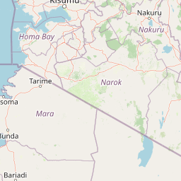
Map view of Ruma National Park

Use this park location map to pinpoint Ruma National Park in Kenya, understand its exact geographic position, and read its mapped placement within the surrounding landscape more clearly.

Pigeon | © OpenStreetMap contributors

Location context for Ruma National Park

Nyanza Province
Park atlas

Map nearby protected landscapes and trace the regional spread of conservation areas around Ruma National Park

Compare National Parks and Protected Areas Near Ruma National Park in Western Kenya
Expand your exploration from Ruma National Park to browse other national parks and protected areas within Kenya's diverse regional geography, comparing adjacent savanna ecosystems and varied conservation landscapes. This geographic context helps you trace the distribution of important protected areas, understand unique terrain features, and discover ecological strongholds beyond Ruma's specific profile.
National parkMara Region

Serengeti National Park: National Park Atlas and Protected Landscape Discovery

Explore savanna grasslands, regional geography, and mapped park boundaries.

Serengeti National Park, a significant national park within Tanzania's Mara Region, offers an unparalleled view into a vast protected landscape. This page provides access to the park's geographic identity, its defining savanna ecosystem, and its role as a critical component of the regional atlas. Understand the mapped extent of its protected boundaries and the unique natural context that supports its renowned wildlife.

Area
14,763 km²
Established
1940
IUCN
II
Visitors
350K annual
National parkUganda

Mount Elgon National Park: Uganda's Transboundary Volcano and Mapped Protected Area

Explore volcanic terrain, unique cave systems, and diverse montane landscapes.

Mount Elgon National Park offers a rich tapestry of protected landscapes, centered on a dormant shield volcano straddling the Uganda-Kenya border. This park is recognized for its extraordinary botanical diversity and spectacular cave systems, such as Kitum Cave, where wildlife congregates to lick salt. The elevation gradient supports distinct vegetation zones, from dense montane forests to high-altitude heath and moorland, providing crucial habitat and watershed protection. Understanding Mount Elgon National Park through its mapped boundaries and geographic context reveals a unique protected area in East Africa.

Area
1,279 km²
Established
1968
IUCN
II
Relief
Mountain
National parkTrans-Nzoia County

Saiwa Swamp National Park National Park: Mapped Protected Area in Trans-Nzoia County

Explore the geographic context and protected landscape features.

Saiwa Swamp National Park serves as a vital national park within Trans-Nzoia County, Kenya, offering a unique perspective on protected lands. This page details its mapped geography and landscape characteristics, providing essential context for atlas-based exploration of its protected boundaries and regional setting. Understand the specific features that define this important conservation area.

Area
3 km²
Established
1974
IUCN
II
Relief
Lowland
National parkNakuru County

Hell's Gate National Park: National Park Atlas and Mapped Landscape Exploration

Discover Nakuru County's protected terrain and geographic context.

Explore the mapped boundaries and unique geographic identity of Hell's Gate National Park, a protected national park within Kenya's Nakuru County. This detailed atlas view focuses on the park's natural landscape and its place within the regional geography, offering structured discovery of its protected terrain and surrounding context. Understand the visual and geographic essence of this significant conservation area.

Area
68.25 km²
Established
1984
IUCN
II
Relief
Mountain
National parkMwanza Region

Saanane Island National Park: Tanzania National Park with Mapped Protected Landscape Identity

Discover its geographic context within Mwanza Region and atlas exploration value.

Saanane Island National Park represents a key protected area within the Mwanza Region of Tanzania. This detailed entry focuses on its identity as a national park, emphasizing its mapped boundaries and geographic presence. It's designed for users seeking a structured understanding of its landscape context and its place within a broader atlas of protected natural areas, offering factual, geography-focused discovery.

Area
2.8 km²
Established
2013
IUCN
II
Visitors
5.3K annual
National parkNyeri County

Aberdare National Park: Mapped Protected Landscape in Nyeri County

National Park Geography and Atlas Context

Aberdare National Park is a protected national park located within Nyeri County, Kenya. This entry offers detailed geographic information and map context, highlighting its protected boundaries and landscape characteristics. Users can explore its regional setting, understand its specific terrain features, and discover its significance as a conservation area within the Kenyan geography. Access structured data that clarifies the park's identity as a vital protected landscape.

Area
767 km²
Established
1950
IUCN
II
Relief
Mountain
National parkKenya

Nairobi National Park: Detailed Geographic Overview and Protected Landscape Atlas

Explore the mapped boundaries and regional context of this Kenyan national park.

Nairobi National Park represents a significant protected national park entity within Kenya. This MoriAtlas entry provides detailed insight into its geographic placement and mapped landscape characteristics. Users can delve into the park's specific location, its protected boundaries, and its contribution to the regional geography of East Africa, facilitating structured map-based exploration and understanding of this vital conservation area.

Area
117 km²
Established
1946
IUCN
II
Relief
Mixed relief
National parkGeita Region

Rubondo Island National Park: Tanzanian National Park Geography and Mapped Boundaries

Explore the protected landscape within Geita Region.

Delve into the protected landscape of Rubondo Island National Park, a designated national park situated in Tanzania's Geita Region. This page provides essential geographic context, detailing the park's mapped boundaries and its contribution to the regional atlas. Understanding Rubondo Island National Park involves exploring its specific terrain and its significance as a protected natural area within the broader landscape.

Area
456.8 km²
Established
1965
IUCN
II
Visitors
1.5K annual

Common questions about visiting, size, designation, and location context for Ruma National Park

Ruma National Park FAQs for park facts, access, geography, and protected area context
Find quick answers about Ruma National Park, including protected-area facts, park geography, trail and visitor context, and how the park fits into its surrounding country and regional landscape.
MoriAtlas Explorer

Continue Your Protected Areas Search Across the Global Atlas

Deepen your exploration by continuing the structured search for national parks and protected areas worldwide. Utilize the comprehensive filtering capabilities to compare different conservation landscapes and refine your understanding of global park geography. Discover more about the distribution and characteristics of protected natural areas.

Global natural geography