Mori Atlas logo
Nature reserveRzeka San

A vital river corridor and Natura 2000 protected area within the Carpathian foothills geography

Rzeka San Nature Reserve: Mapped Protected Riverine Landscape in Podkarpackie Voivodeship, Poland

Rzeka San represents a critical riverine protected area spanning the Podkarpackie Voivodeship, specifically catalogued for its role in maintaining riparian habitats and aquatic species connectivity. This nature reserve, designated within the Natura 2000 framework, preserves essential gravel beds and dynamic water channels that link the Carpathian foothills to the wider Vistula drainage. Its unique geographic reach creates a layered conservation landscape that overlaps with regional zones, including the Pogórze Przemyskie Landscape Park.

river habitatfreshwater conservationfreshwater musselsmigratory fishAtlantic salmonCarpathian foothills

Rzeka San

Nature reserve

Park overview

Structured park overview, official facts, and landscape profile for Rzeka San

Rzeka San park facts, protected area profile, and essential visitor context

Review the core facts for Rzeka San, including designation, size, terrain, visitor scale, habitats, and operating context in one park-focused overview.

About Rzeka San

Rzeka San is a linear, river-based Special Area of Conservation in the EU Natura 2000 network, situated in the Podkarpackie Voivodeship of southeastern Poland. The site follows the course of the San River, one of the principal right-bank tributaries of the upper Vistula, from the city of Sanok downstream to Jarosław. In geographical terms it lies within the Pogórze Dynowskie foothills and the Dolina Dolnego Sanu valley, transitioning between submontane terrain and broader lowland river corridor.

Designated under the Habitats Directive, the site is catalogued as PLH180007 and protects habitat conditions for a community of freshwater species. The Polish description of the area emphasizes eleven species from Annex II, including the brook lamprey (Lampetra planeri), the Carpathian gudgeon complex (Gobio kessleri and Gobio albipinatus), the peloponnese barbel (Barbus peloponessius), the asp (Aspius aspius), the bitterling (Rhodeus sericeus amarus), the bullhead (Cottus gobio), the spined loach (Cobitis taenia), the golden loach (Sabanajewia aurata), the Atlantic salmon (Salmo salar), and the thick-shelled river mussel (Unio crassus). Each of these species depends on particular riverbed structure, water quality, and connectivity, conditions that the protected status is intended to maintain.

Much of the site falls inside the boundaries of larger landscape-level conservation units. The Pogórze Przemyskie Landscape Park accounts for the largest share of the site's territory, with the Wschodniobeskidzki Protected Landscape Area also contributing a significant portion. This nesting of protections means that visitors and managers experience the area as part of the broader San River valley, where landscape, scenic, and ecological protections intersect.

The site's administration crosses several Polish powiats, including Sanok, Rzeszów, Przemyśl, Brzozów, and Jarosław, along with the city of Przemyśl, which sits prominently along the protected river corridor. This multi-county character reflects the linear nature of the protection, hugging the river's path across local administrative boundaries.

Quick facts and research context for Rzeka San

Rzeka San (Natura 2000 code PLH180007) is a Special Area of Conservation in the Podkarpackie Voivodeship of southeastern Poland, protecting roughly 1,374 hectares of the San River between Sanok and Jarosław.

The site was initially proposed as a Site of Community Importance in March 2009, following a European Commission decision of December 2008, and was formally confirmed as a Special Area of Conservation in 2017 by ministerial regulation. It spans parts of several counties, including Sanok, Rzeszów, Przemyśl, Brzozów, and Jarosław, together with the city of Przemyśl, and lies within the Pogórze Dynowskie and Dolina Dolnego Sanu physical-geographical mesoregions.

Protection and recognition

Documented conservation status and international recognition records for Rzeka San.

Rzeka San Protection Status and Natura 2000 Recognition Data

Terrestrial protection records and Natura 2000 designations outline the official conservation framework established for Rzeka San. Structured recognition sources provide verified data regarding the administrative scope and international context governing this protected natural area.

International recognition

Protection details

Protection scope
Terrestrial
Park context

Deeper park guide and search-rich context for Rzeka San

Rzeka San history, landscape, wildlife, and travel context

Explore Rzeka San through its history, landscape character, ecosystems, wildlife, conservation priorities, cultural context, and seasonal travel timing in a structured park guide built for atlas discovery and search intent.

Why Rzeka San stands out

Rzeka San is best known as a riverine Natura 2000 site that protects eleven Annex II species of the EU Habitats Directive concentrated along a single reach of the San River. The species list gives the site its conservation character, ranging from lampreys and small bottom-dwelling cyprinids to migratory Atlantic salmon and the thick-shelled river mussel Unio crassus. Its recognition also stems from how it layers with surrounding landscape protections, with significant overlap onto the Pogórze Przemyskie Landscape Park and the Wschodniobeskidzki Protected Landscape Area, reinforcing the ecological value of the San valley.

Rzeka San history and protected-area timeline

Rzeka San was originally proposed as a Site of Community Importance (projektowany specjalny obszar ochrony siedlisk) in March 2009, on the basis of a European Commission decision dated 12 December 2008. This stage placed the area on the EU list of candidate Special Areas of Conservation under the Habitats Directive, marking a formal recognition of the San River corridor's ecological significance.

The site was subsequently confirmed as a Special Area of Conservation in 2017 by a regulation issued by the Polish Minister of the Environment, completing the legal transition from a candidate designation to a fully protected Natura 2000 site. This regulatory step anchored the long-term protection of the area and established the legal framework for managing the eleven Annex II species of concern, including Atlantic salmon and the thick-shelled river mussel.

In the Polish conservation literature, the site has been described in the 2012 regional Natura 2000 volume Obszary Natura 2000 na Podkarpaciu, edited by Rogała and Marcela for the Regional Directorate for Environmental Protection in Rzeszów, providing a published reference point for the area's ecological profile and management context.

Rzeka San landscape and geographic character

The landscape of Rzeka San is defined by the river corridor itself, cutting through the transition between submontane foothills and the broader lowland valley of the lower San. The site falls within two physical-geographical mesoregions: Pogórze Dynowskie, where the river leaves the more confined Carpathian foothills, and Dolina Dolnego Sanu, the wider valley that the river forms as it approaches the Vistula lowlands.

Topography along the protected reach is shaped by the alternation of valley flats, low terraces, and gentle slopes descending from the surrounding foothills. The river corridor includes both main channel features and adjacent riparian zones, with gravel beds, banks, and associated waterside vegetation characteristic of a dynamic Carpathian tributary system.

Because much of the territory overlaps with the Pogórze Przemyskie Landscape Park, the landscape setting also includes the surrounding foothills of the Przemyśl range, framed by agricultural land and forested ridges. The visual identity of the area is therefore one of an active river set against the rolling green backdrop of the eastern Carpathian foothills and the wider landscape protection mosaic of the region.

Rzeka San ecosystems, habitats, and plant life

Ecologically, Rzeka San is a freshwater and riparian habitat complex characteristic of a medium-sized Carpathian river. The site's nature value is strongly species-led, with the conservation framework organized around Annex II fauna rather than around broad terrestrial habitat types.

The river supports communities of small bottom-dwelling species such as the brook lamprey and the bullhead, alongside cyprinid species like the Carpathian and white-finned gudgeons, the spined and golden loaches, and the bitterling. Larger migratory and predatory species, including Atlantic salmon and asp, link the protected river reach to the wider Baltic and Vistula drainage systems, making continuity of habitat along the river a key ecological feature.

The presence of Unio crassus, the thick-shelled river mussel, adds a freshwater bivalve dimension to the site's ecological profile, since this species depends on stable riverbeds and good water quality. Together, these fauna point to a protected river system valued less for high species counts and more for the ecological integrity of the river itself, supported by the layered protections of the landscape parks and protected landscape areas that overlap the site.

Rzeka San wildlife and species highlights

The wildlife profile of Rzeka San is built around its freshwater fauna rather than around terrestrial mammals or breeding birds, and is unusually well defined because the site's conservation interest hinges on a small list of Annex II species. This makes the species assemblage itself a defining element of the area's identity.

Fish species of central interest include migratory and resident forms of the San, with Atlantic salmon representing the river's connection to long-distance migratory pathways, and asp serving as a predatory fish indicative of a relatively intact trophic structure. Smaller and often overlooked species form the backbone of the site, including the brook lamprey, gudgeons of the Gobio genus, the peloponnese barbel, bitterling, bullhead, and the spined and golden loaches, each reflecting particular microhabitats along the river.

The freshwater mussel Unio crassus completes the wildlife picture, providing a presence of large bivalves in the riverbed that depend on fish hosts for part of their life cycle. Although the species list is focused, it reflects a working Carpathian river ecosystem whose conservation is anchored to the continued functioning of the San as a flowing-water habitat.

Rzeka San conservation status and protection priorities

From a conservation perspective, Rzeka San is significant because it anchors EU-level protection onto a single functioning river corridor in southeastern Poland. By targeting the river reach from Sanok to Jarosław, the site concentrates Natura 2000 attention on a length of river that links the Polish Carpathians with downstream Vistula tributaries, supporting species that depend on connectivity.

The site's formal progression from a candidate Site of Community Importance in 2009 to a fully designated Special Area of Conservation in 2017 reflects a long, deliberate legal pathway, giving the area a stable institutional framework. The protection extends beyond the river itself through significant overlap with larger conservation units, most notably the Pogórze Przemyskie Landscape Park, which accounts for a substantial share of the site's area, and the Wschodniobeskidzki Protected Landscape Area, adding a buffer of landscape-level protection around the river.

What makes Rzeka San valuable as a conservation unit is not its size but its targeted role: protecting eleven Annex II species along an ecologically continuous river reach, in a region where the same valley is already valued at the landscape level. This layering of habitat-, landscape-, and species-level protections gives the area a strong basis for long-term freshwater conservation in the Polish Carpathians.

Rzeka San cultural meaning and human context

The cultural context of Rzeka San is intertwined with the San River valley itself, a long-standing corridor of settlement, transport, and regional identity in the Podkarpackie region. The protected river reach passes through several historically important centers, including the city of Przemyśl, a notable borderland and historical hub of southeastern Poland, and connects Sanok, Jarosław, and other towns that have shaped the valley's local identity.

The presence of overlapping landscape protections, particularly the Pogórze Przemyskie Landscape Park, reflects a regional tradition of recognizing the San valley as both an ecological and a cultural landscape. While the Natura 2000 site itself is defined around ecological criteria, the surrounding area carries a strong sense of regional heritage tied to the river's role in connecting Carpathian communities with the broader lowland Poland.

Top sights and standout views in Rzeka San

A typologically focused riverine Natura 2000 site, Rzeka San stands out for protecting eleven Annex II species along a single reach of the San River, including lampreys, gudgeons, Atlantic salmon, and the thick-shelled river mussel.

Its layered character, with strong overlap onto the Pogórze Przemyskie Landscape Park and the Wschodniobeskidzki Protected Landscape Area, makes it a notable example of how European species protection can be embedded in a broader national landscape conservation framework.

Best time to visit Rzeka San

As a river-based protected area centered on ecological rather than scenic tourism, the relevance of timing for visiting Rzeka San is mainly connected to the seasonal behavior of the river and the surrounding landscape. The Carpathian foothills and the San valley are most visually active from late spring through early autumn, when vegetation cover is at its peak and lower water levels make the river corridor more approachable.

For anyone interested in observing the broader landscape of the area rather than specific species, the warmer months offer the most favorable conditions for exploring the overlapping Pogórze Przemyskie Landscape Park and the Wschodniobeskidzki Protected Landscape Area. Specific conservation or wildlife observation windows are not detailed in the available source material, so any narrower timing for particular species should be sought from current local guidance.

Monthly climate preview

Long-term representative coordinates reveal measured monthly weather patterns across the terrain

Rzeka San Climate Normals, Annual Temperature and Monthly Precipitation Profile

Representative coordinate records outline the long-term annual temperature and precipitation rhythm measured across Rzeka San from 1991 through 2020. Deeper monthly climate normals detail twelve distinct temperature ranges and precipitation rates for comprehensive regional study.
Annual mean8 °C
-4 °C20 °C
Jan-4°
Feb-2°
Mar
Apr
May14°
Jun18°
Jul20°
Aug20°
Sep14°
Oct
Nov
Dec-2°
Warmest month
July

20 °C

Coolest month
January

-3.9 °C

Wettest month
July

2.9 mm/day

Driest month
January

1.2 mm/day

Park location guide

Geography guide, regional context, and park location map for Rzeka San

Rzeka San park geography, regions, and map view in Poland

Understand where Rzeka San sits in Poland through a broader geographic reading of the surrounding landscape, nearby location context, and its mapped position within the national park landscape.

How Rzeka San fits into Poland

Poland, officially the Republic of Poland, is a Central European country spanning from the Baltic Sea in the north to the Carpathian Mountains in the south. It borders Germany, Czech Republic, Slovakia, Ukraine, Belarus, Lithuania, and Kaliningrad Oblast. The country has a temperate climate, diverse landscapes, and is known for its rich history, cultural heritage, and strong economic position within the EU.

Wider geography shaping Rzeka San in Poland

Poland occupies 312,696 km2 in Central Europe, extending from the Baltic Sea coast in the north to the Sudetes and Carpathian Mountains in the south. It borders Germany to the west, Czech Republic and Slovakia to the south, Ukraine and Belarus to the east, and Lithuania and Kaliningrad Oblast to the northeast. The landscape includes lowland plains, uplands, and mountain ranges.

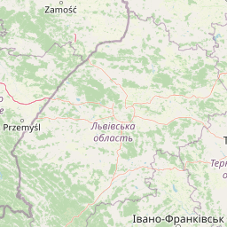
Map view of Rzeka San

Use this park location map to pinpoint Rzeka San in Poland, understand its exact geographic position, and read its mapped placement within the surrounding landscape more clearly.

Pigeon | © OpenStreetMap contributors

Location context for Rzeka San

Podkarpackie Voivodeship
Recorded earthquake history

Place Rzeka San's associated earthquake records in map context

Open the historical catalogue to inspect recorded epicentre locations relative to Rzeka San Nature Reserve and compare their geographic distance. Use the data as an atlas reference only, never as a live feed, safety assessment, causal explanation, or earthquake forecast.

View nearby earthquake records

Catalogued events

1 event

Strongest magnitude

Magnitude 3.6

Most recent event

Jun 29, 1992

This history includes earthquakes recorded inside the park or within 50 km of its borders

Park atlas

Discover related protected landscapes and regional river conservation zones

Parks Near Rzeka San, Exploring Protected Areas and River Valleys

Compare Rzeka San with other protected areas across the surrounding southeastern Polish river basin and foothill terrain. Analyzing adjacent river corridors and connected conservation zones reveals wider regional biodiversity patterns.
Protected areaPodkarpackie Voivodeship
Park boundaries overlap#1 closest

South

Ostoja Góry Słonne: Geographic Analysis of Protected Carpathian Forest and Foothills

Mapping natural boundaries in the Podkarpackie Voivodeship

Ostoja Góry Słonne represents a significant protected area within the Polish Carpathians, characterized by its dense beech forest cover and high biodiversity. This site serves as a vital refuge for large mammals and diverse riparian species, with its landscape of forested ridges and river valleys providing essential habitat connectivity across the Słonne Mountains and Przemyskie Foothills.

Area
460.715 km²
Established
2009
Relief
Mountain
Climate
Temperate
Protected areaPodkarpackie Voivodeship
5.4 km away#2 closest

Southwest

Sanisko w Bykowcach Protected Area: Riverine and Floodplain Landscape Mapping

Ecological terrain study of the Osława and San river confluence.

Sanisko w Bykowcach encompasses a dense cluster of Annex I habitats, including old river arms, riparian forests, and fresh meadows. This site demonstrates the interplay between river dynamics and land management in the Podkarpackie region, offering a clear view of wetland ecological transitions.

Area
0.798 km²
Established
2011
Relief
Upland
Scope
Terrestrial
A horizontal watercolor illustration showing a soft, impressionistic landscape of green meadows, small clusters of trees, and pale, distant rolling hills.
Protected areaSubcarpathian Voivodeship
9 km away#3 closest

North

Starodub w Pełkiniach Protected Area: Regional Landscape and Meadow Geography Map

Protected grassland habitat in Subcarpathian Voivodeship

Starodub w Pełkiniach is a specialized protected area in Poland, renowned for its extensive, unbroken meadow complex. The site sits where the Podgórze Rzeszowskie foothills meet the fertile Lower San River valley, creating a distinct geographic mosaic. This protected landscape is fundamental for conserving Annex II botanical species, maintaining traditional agricultural management at a significant scale across the local terrain.

Area
5.748 km²
Established
2011
Relief
Lowland
Water
Minor water
A watercolor illustration showing a landscape with a calm body of water, grassy banks, and rolling hills in the background.
Nature reservePodkarpackie Voivodeship
About 10 km away#4 closest

West

Mójka Nature Reserve: A Detailed Atlas View of Carpathian Foothill Protected Landscapes

Examining beech-fir forest and wetland habitats in Podkarpackie

Mójka Nature Reserve protects a 288 hectare forest environment within the Hyżnieńsko-Gwoźnicki Protected Landscape Area. This geographic entity showcases a mosaic of moist forest and aquatic habitats, documenting 340 vascular plant species and significant beaver-influenced hydrology in the rolling terrain of the Pogórze Dynowskie foothills.

Area
2.884 km²
Established
1997
Relief
Upland
Climate
Temperate
Protected areaPodkarpackie Voivodeship
12 km away#5 closest

Southwest

Patria nad Odrzechową: A Detailed Geographic Study of Protected Polish Carpathian Forest Lands

Deciduous forest mosaic in the Bukowskie Foothills

Patria nad Odrzechową is a key protected area in Poland, renowned for its concentration of European-priority beech and oak-hornbeam forests. The site provides a compact, representative look at the transitional forest ecology of the Subcarpathian region, preserved within the larger Beskid Niski landscape framework. Explore the specific habitat boundaries and terrain features that define this essential woodland corridor.

Area
5.73 km²
Established
2011
Relief
Upland
Scope
Terrestrial
Protected areaPodkarpackie Voivodeship
15 km away#6 closest

Northeast

Łukawiec Protected Area Mapping and Landscape Context in the Podkarpackie Voivodeship

Fragmented forest and wetland habitats in southeastern Poland

Łukawiec represents a vital ecological intersection in the Podkarpackie Voivodeship, preserving rare forest types and wetland systems on the Płaskowyż Tarnogrodzki plateau. This site is defined by its complex mosaic of riparian woodlands, Molinia meadows, and boggy coniferous patches that sustain a variety of protected animal species.

Area
22.702 km²
Established
2011
Relief
Upland
Scope
Terrestrial
Nature reservePodkarpackie Voivodeship
About 15 km away#7 closest

Southwest

Dyrbek Nature Reserve: Protected Carpathian Beech Forests and Słonne Mountains Geography

A mountain forest refuge in the Podkarpackie Voivodeship

Dyrbek Nature Reserve functions as a critical forest conservation area, sheltering mature beech communities within the rugged topography of the Słonne Mountains. This site offers insight into the mesic forest ecosystems of the Eastern Carpathians, serving as a haven for sensitive raptors and forest birds that rely on undisturbed canopy cover in the southeastern Polish highlands.

Area
1.301 km²
Established
1996
Relief
Mountain
Climate
Temperate
Nature reservePodkarpackie Voivodeship
16 km away#8 closest

West

Wisłok Środkowy z Dopływami Protected Nature Reserve in the Podkarpackie Voivodeship

River corridor geography and riparian ecosystem analysis

Wisłok Środkowy z Dopływami serves as a crucial Natura 2000 site, safeguarding the middle course of the Wisłok River and the Stobnica tributary. This nature reserve provides essential habitat for various protected fish species and butterfly populations within a terrain shaped by the transition between the Jasielsko-Krośnieńska Basin and the Carpathian foothills. The area represents a significant riparian landscape, offering a window into the natural freshwater geography of southeastern Poland.

Area
10.646 km²
Established
2011
Relief
Upland
Scope
Terrestrial

Common questions about visiting, size, designation, and location context for Rzeka San

Rzeka San FAQs for park facts, access, geography, and protected area context

Find quick answers about Rzeka San, including protected-area facts, park geography, trail and visitor context, and how the park fits into its surrounding country and regional landscape.
MoriAtlas Explorer

Continue Your Protected Areas Search Across the Global Atlas

Deepen your exploration by continuing the structured search for national parks and protected areas worldwide. Utilize the comprehensive filtering capabilities to compare different conservation landscapes and refine your understanding of global park geography. Discover more about the distribution and characteristics of protected natural areas.

Global natural geography