Mori Atlas logo
National parkSacred Mountain National Park

Discover the mapped boundaries and protected landscape of Sacred Mountain National Park.

Sacred Mountain National Park: National Park Detailed Geographic and Atlas Exploration in Lanao del Sur

Sacred Mountain National Park stands as a designated national park within the region of Lanao del Sur, Philippines. This page offers detailed geographic context and an atlas-oriented view of its protected landscape, enabling exploration of its mapped boundaries and regional setting. Understand Sacred Mountain National Park's unique place within the natural geography of the Philippines through structured data and map-based discovery tools.

protected landscapemountain parktrekking destinationMindanaoLanao del Surbirdwatching

Sacred Mountain National Park

National park

Park overview

Structured park overview, official facts, and landscape profile for Sacred Mountain National Park

Sacred Mountain National Park park facts, protected area profile, and essential visitor context
Review the core facts for Sacred Mountain National Park, including designation, size, terrain, visitor scale, habitats, and operating context in one park-focused overview.

About Sacred Mountain National Park

Sacred Mountain National Park provides a protected area in the Southern Philippines that balances natural landscape preservation with the cultural context of the surrounding communities in Lanao del Sur. The park's establishment in 1965 reflected the Philippines' broader mid-20th century effort to designate national parks across the archipelago, though its naming as Sacred Mountain rather than its local indigenous name has become a point of discussion. The protected area occupies a mountainous terrain with Mount Mupo as its defining feature, providing a visual landmark visible from the nearby city of Marawi. Visitors to the park can engage in trekking activities that lead to the mountain's summit pond, as well as birdwatching among the park's vegetation communities. The park's location in a region with deep cultural and historical significance adds dimension to its conservation role, as it exists within a landscape shaped by generations of local community presence and traditional land use practices.

Quick facts and research context for Sacred Mountain National Park

Sacred Mountain National Park occupies 94 hectares in Lanao del Sur, Mindanao, Philippines, with Mount Mupo as its dominant geographic feature at 274.32 meters elevation. The park was established on August 5, 1965, and is managed by the Department of Environment and Natural Resources. The protected area supports trekking to a mountaintop pond and birdwatching activities. Native vegetation includes Buyo Buyo (Piper abbreviatum), while non-native species such as African tulip trees have also become established in the park ecosystem.

Park context

Deeper park guide and search-rich context for Sacred Mountain National Park

Sacred Mountain National Park history, landscape, wildlife, and travel context
Explore Sacred Mountain National Park through its history, landscape character, ecosystems, wildlife, conservation priorities, cultural context, and seasonal travel timing in a structured park guide built for atlas discovery and search intent.

Why Sacred Mountain National Park stands out

Sacred Mountain National Park is best known for its compact but distinctive mountainous terrain centered on Mount Mupo, which offers a achievable trekking destination with a pond at the summit. The park represents one of the smaller protected areas in the Philippines but holds cultural significance beyond its land area due to the ongoing discussion about restoring its indigenous name. It serves as a rare example of a protected landscape in the Muslim-majority region of Lanao del Sur, where conservation and cultural heritage intersect.

Sacred Mountain National Park history and protected-area timeline

Sacred Mountain National Park was established on August 5, 1965, through Republic Act No. 4190, which authorized the creation of national parks throughout the Philippines during a period of active protected area designation. The park was set aside as a protected area during an era when the national government retained significant influence over naming conventions, resulting in the designation of Sacred Mountain rather than preservation of the indigenous local name for the mountain. This naming choice reflects the broader colonial and post-colonial administrative context where indigenous toponyms were often superseded by English or Spanish-derived designations. In more recent years, some local community members have advocated for renaming the park to better reflect the indigenous identity of the locality and to acknowledge the cultural significance of the mountain to local communities. The park remains under the management of the Department of Environment and Natural Resources and continues to operate as a protected landscape under IUCN category V classification.

Sacred Mountain National Park landscape and geographic character

The landscape of Sacred Mountain National Park is defined by its central topographic feature, Mount Mupo, which rises approximately 274 meters above sea level. The volcanic formation creates a distinct elevated terrain within the otherwise relatively flat surrounding landscape of Lanao del Sur. The mountain supports a summit pond that serves as a destination point for park visitors undertaking trekking activities. The terrain transitions from the lower slopes through forested sections to the rocky and vegetated summit area. The park's 94-hectare boundary encompasses both the mountain slopes and adjacent areas in barangays Guimba and Papandayan, creating a protected zone that preserves the mountain's ecological integrity and visual prominence in the regional landscape.

Sacred Mountain National Park ecosystems, habitats, and plant life

The ecological character of Sacred Mountain National Park reflects a mix of native and introduced plant species adapted to the mountain environment. The park features Buyo Buyo (Piper abbreviatum) as a dominant native plant species, contributing to the vegetation character of the slopes and lower terrain. Non-native flora, particularly African tulip trees, have become established within the park boundaries, representing vegetation that has spread beyond original planting. The park's natural communities provide habitat support for bird species, enabling birdwatching as an activity within the protected area. The mountainous setting creates varied microhabitats from the base to the summit, with differences in moisture, sunlight, and soil conditions supporting diverse plant associations.

Sacred Mountain National Park wildlife and species highlights

Sacred Mountain National Park supports birdwatching activities, indicating the presence of avian species within its boundaries. The park's vegetation communities and varied terrain from base to summit create habitat conditions that support bird life in the Lanao del Sur area. While specific species lists are not detailed in available sources, the protected landscape function of the park suggests it serves as a habitat area for common tropical bird species found in the Mindanao region. The mountain's isolated position within the agricultural and settled landscape surrounding Marawi creates a green refuge that supports wildlife movement and habitat continuity.

Sacred Mountain National Park conservation status and protection priorities

Sacred Mountain National Park holds IUCN category V classification as a protected landscape, indicating recognition that the area's natural values are intertwined with the cultural landscape shaped by human activity. The protected area designation preserves the mountainous terrain and its ecological communities while allowing for sustainable human uses such as traditional activities and controlled visitor access. The park's conservation value extends to its role in maintaining a visual and ecological landmark within the Lanao del Sur landscape. Ongoing community interest in the park's naming reflects a broader engagement with conservation and cultural heritage that shapes how protected areas are understood and valued by local populations.

Sacred Mountain National Park cultural meaning and human context

The cultural context of Sacred Mountain National Park is defined by its location in Lanao del Sur, a province with a predominantly Maranao Muslim population and deep cultural heritage in the Southern Philippines. The mountain has an indigenous local name that predates the colonial-influenced naming of the national park, and community advocacy for renaming the protected area reflects broader movements to reclaim indigenous identity in Philippine conservation and governance. The park exists within a landscape of traditional land use and community presence, where the concept of protected areas operates within different cultural frameworks than in other Philippine regions. The presence of barangays Guimba and Papandayan within or adjacent to the park boundary indicates the continued presence of local communities whose relationship with the mountain shaped its cultural significance before formal protected area designation.

Top sights and standout views in Sacred Mountain National Park

Sacred Mountain National Park offers trekking to the summit of Mount Mupo, where a natural pond provides a distinctive destination within the 94-hectare protected area. The park's small size makes it an accessible hiking destination for visitors in the Marawi area, with the 274-meter elevation providing panoramic views from the top. The ongoing conversation about restoring the park's indigenous name highlights its cultural significance and represents a meaningful intersection of conservation and cultural identity in the Southern Philippines. Birdwatching opportunities complement the trekking experience, while the park's classification as a protected landscape reflects its role in preserving a culturally significant mountain within Lanao del Sur.

Best time to visit Sacred Mountain National Park

The best time to visit Sacred Mountain National Park corresponds to the dry season typical of the Southern Philippines, generally from March through May, when lower rainfall allows for more comfortable trekking conditions on the mountain trails. The wet season from June through November brings higher precipitation that can make trails more difficult and conditions less predictable for outdoor activities. Year-round visits are possible, but travelers should account for the tropical climate of Mindanao and the potential for rain at any time. Early morning visits are advisable for those seeking cooler temperatures during trekking activities and for optimal birdwatching conditions.
Park location guide

Geography guide, regional context, and park location map for Sacred Mountain National Park

Sacred Mountain National Park park geography, regions, and map view in Philippines
Understand where Sacred Mountain National Park sits in Philippines through a broader geographic reading of the surrounding landscape, nearby location context, and its mapped position within the national park landscape.

How Sacred Mountain National Park fits into Philippines

The Philippines, officially the Republic of the Philippines, is an archipelagic nation in Southeast Asia comprising approximately 7,641 islands categorized into three main geographical divisions: Luzon, Visayas, and Mindanao. Located in the western Pacific Ocean, it shares maritime borders with Taiwan, Japan, Palau, Indonesia, Malaysia, Vietnam, and China. Manila serves as the capital city, while Quezon City is the most populated city, both within Metro Manila.

Wider geography shaping Sacred Mountain National Park in Philippines

The Philippines is an archipelagic nation in Southeast Asia, positioned in the western Pacific Ocean. Its islands are bounded by the South China Sea to the west, Philippine Sea to the east, and Celebes Sea to the south. The country shares maritime borders with Taiwan to the north, Japan to the northeast, Palau to the east and southeast, Indonesia to the south, Malaysia to the southwest, Vietnam to the west, and China to the northwest.

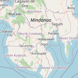
Map view of Sacred Mountain National Park

Use this park location map to pinpoint Sacred Mountain National Park in Philippines, understand its exact geographic position, and read its mapped placement within the surrounding landscape more clearly.

Pigeon | © OpenStreetMap contributors

Location context for Sacred Mountain National Park

Lanao del Sur
Park atlas

Expand your exploration from Sacred Mountain National Park, tracing protected landscapes and regional park geography in the Southern Philippines.

Discover Nearby Protected Areas and Regional Parks Surrounding Sacred Mountain National Park
Browse a curated selection of national parks and protected areas geographically connected to Sacred Mountain National Park in Lanao del Sur. Compare the distinct terrain, conservation status, and cultural landscapes of these protected lands to deepen your understanding of the Southern Philippines.
National parkLanao del Sur

Lake Butig National Park: National Park Atlas and Geographic Discovery in Lanao del Sur

Discover its mapped boundaries and regional landscape context.

Lake Butig National Park is a protected national park in the Philippines, located within Lanao del Sur. This entry provides specific geographic information and supports atlas exploration by detailing the park's mapped boundaries and its place within the regional landscape. Understand the terrain and protected area context crucial for geographic study and understanding Philippine natural landscapes.

Area
0.68 km²
Established
1965
IUCN
V
Relief
Mountain
National parkLanao del Sur

Pantuwaraya Lake National Park: National Park Atlas and Mapped Landscape

Explore the protected area and regional geography of Lanao del Sur.

Understand Pantuwaraya Lake National Park as a defined protected landscape and a significant national park within the Philippines. This entry focuses on its geographic placement in Lanao del Sur, providing context for its mapped boundaries and natural features. Users can explore its representation within a broader atlas of protected lands, gaining insight into its role and landscape identity.

Area
0.2 km²
Established
1965
IUCN
V
Climate
Tropical
National parkLanao del Sur

Salikata National Park: Explore Philippines National Park Geography

Mapped protected area boundaries and regional context.

Investigate Salikata National Park, a key protected area designated as a national park within Lanao del Sur, Philippines. This detailed view provides essential context for understanding its mapped boundaries, its place in the regional geography, and its significance as a protected landscape. Discover the unique geographic attributes that define Salikata National Park for atlas-based exploration.

Established
1965
IUCN
V
Relief
Mountain
Climate
Tropical
National parkMaguindanao del Norte

Mado Hot Spring National Park: Protected Geothermal Landscape in Maguindanao del Norte

Explore its therapeutic hot springs and mapped boundaries

Mado Hot Spring National Park, located in Maguindanao del Norte, Philippines, is a protected area defined by its geothermal features and therapeutic hot springs. This national park, established early in the Philippines' conservation history, offers a unique landscape centered around a warm mineral-rich natural pool. Delve into the geographic context and protected area identity of this distinctive site, understanding its role within the region's natural heritage.

Area
0.48 km²
Established
1939
IUCN
II
Scope
Terrestrial
National parkCebu

Guadalupe Mabugnao Mainit Hot Spring National Park: Protected Landscape and Watershed Geography

Explore hot springs, caves, and mapped terrain in Cebu.

Guadalupe Mabugnao Mainit Hot Spring National Park is a protected national park in Cebu, Philippines, recognized for its significant watershed function and unique natural features. Spanning forested highland terrain within the Mantalongon mountain range, the park protects natural hot springs, explored cave systems such as Cave Lorett, and river networks vital to local water supply. Its identity as a protected landscape offers rich opportunities for geographic exploration, mapping its boundaries, and understanding its role within the regional natural terrain and conservation efforts.

Area
0.575 km²
Established
1972
IUCN
V
Relief
Mountain
National parkPhilippines

Kuapnit Balinsasayao National Park: Philippines Old-Growth Forest and Endemic Wildlife Atlas

Explore protected landscape boundaries and mountainous terrain on Leyte Island.

Kuapnit Balinsasayao National Park stands as a key protected area within the Philippines, distinguished by its mature old-growth forests and its critical role in conserving endemic bird species unique to the Eastern Visayas. Located on Leyte Island within the mountainous terrain of the Anonang-Lobi Mountain Range, the park's protected landscape identity is central to understanding its geographic significance. This park offers a valuable entry point for exploring the mapped natural features and conservation importance of protected areas across the Philippine archipelago.

Area
3.64 km²
Established
1937
IUCN
V
Relief
Mountain
National parkPalo

MacArthur Landing Memorial National Park: Protected Area Geography & Map Context

Explore the mapped boundaries of this national park in Palo, Philippines.

This entry details MacArthur Landing Memorial National Park, a protected national park located near Palo, Philippines. It focuses on its identity as a mapped landscape and a distinct protected area, offering insights into its geographic context and atlas presence. Understanding this park involves exploring its mapped boundaries and its contribution to the regional protected area landscape, providing a factual basis for geographic discovery.

Area
0.068 km²
Established
1977
Relief
Lowland
Climate
Tropical
National parkPhilippines

Bulabog Putian National Park: Philippines National Park Geographic Context and Mapped Boundaries

Discover the protected landscape identity and regional atlas significance.

Bulabog Putian National Park stands as a designated national park in the Philippines, offering valuable insights for geographic and protected-area exploration. Users can understand its specific location and mapped presence within the country's natural landscape, contributing to a structured atlas of conservation areas. This entry focuses on the park's identity and geographic setting for informed discovery.

Area
8.543 km²
Established
1961
IUCN
V
Relief
Mountain

Common questions about visiting, size, designation, and location context for Sacred Mountain National Park

Sacred Mountain National Park FAQs for park facts, access, geography, and protected area context
Find quick answers about Sacred Mountain National Park, including protected-area facts, park geography, trail and visitor context, and how the park fits into its surrounding country and regional landscape.
MoriAtlas Explorer

Continue Your Protected Areas Search Across the Global Atlas

Deepen your exploration by continuing the structured search for national parks and protected areas worldwide. Utilize the comprehensive filtering capabilities to compare different conservation landscapes and refine your understanding of global park geography. Discover more about the distribution and characteristics of protected natural areas.

Global natural geography