Mori Atlas logo
Wildlife reserveSakumo Ramsar Site

A dynamic wetland ecosystem balancing migratory waterbird habitats with coastal savanna geography

Sakumo Ramsar Site Wildlife Reserve: Mapped Coastal Landscapes in the Greater Accra Region

The Sakumo Ramsar Site represents a vital protected landscape along the Gulf of Guinea coast, characterized by its seasonally fluctuating lagoon and varied freshwater marsh terrain. Spanning the urban fringe between Accra and Tema, this coastal wildlife reserve functions as a natural buffer, providing essential habitats for waterbirds while showcasing a complex mosaic of floodplains and savanna grasslands. The area remains a significant study in how protected ecological zones maintain their boundaries and biological function amidst intensive regional development.

wetlandRamsar sitecoastal lagoonImportant Bird Areawaterbirdsmigratory birds

Sakumo Ramsar Site

Wildlife reserve

Park overview

Structured park overview, official facts, and landscape profile for Sakumo Ramsar Site

Sakumo Ramsar Site park facts, protected area profile, and essential visitor context

Review the core facts for Sakumo Ramsar Site, including designation, size, terrain, visitor scale, habitats, and operating context in one park-focused overview.

About Sakumo Ramsar Site

The Sakumo Ramsar Site is one of Ghana's most ecologically significant urban-adjacent wetlands. Located along the coastal road between Accra and Tema in the Greater Accra Region, it represents a rare surviving example of a tropical coastal lagoon system embedded within a heavily urbanized metropolitan area. The site encompasses a dynamic mix of open water, periodically inundated flood-plain, freshwater marsh, and coastal savanna grassland, offering a striking contrast to the surrounding built environment.

At the core of the site is the Sakumo Lagoon, a semi-closed coastal system whose open-water area expands and contracts dramatically with the seasons. During the rainy months the lagoon swells toward its larger footprint, while in the dry season large portions evaporate, producing hyper-saline conditions that reshape the habitat. A controlled sluice maintains a narrow but permanent link to the sea, preventing historical flooding of the coastal road while allowing limited marine exchange.

Beyond its hydrological character, Sakumo stands out for its biodiversity value. Past surveys have documented over seventy waterbird species, with notable counts reaching tens of thousands of individual birds across seasons. The site also supports a recognizable fish fauna that shifts between freshwater, lagoon-resident, and marine visitors depending on rainfall and salinity. While pressures from urbanization, waste, and overfishing are significant, the site remains an important refuge and a focal point for conservation activity in the Greater Accra Region.

Quick facts and research context for Sakumo Ramsar Site

The Sakumo Ramsar Site lies in the Greater Accra Region of Ghana, about 3 kilometers west of Tema, between Accra and the coastline. It was designated as a Ramsar Wetland of International Importance on 14 August 1992, with Ramsar reference number 565. The total designated area is approximately 1,400 hectares, of which the open lagoon itself varies seasonally between roughly 100 and 350 hectares.

A narrow coastal road separates the lagoon from the sea, but a controlled sluice maintains a limited permanent marine connection. The Wildlife Division of the Ghana Forestry Commission is the responsible government agency, and the site has also been recognized as an Important Bird Area by BirdLife International. Surrounding communities include Sakumono, Klagon, and Nungua, and the wetland continues to support farming, fishing, and informal recreation alongside its protected status.

Protection and recognition

Documented protection history, management scope, and Ramsar wetland status

Sakumo Ramsar Site Protection Status and International Recognition Record

Sakumo Ramsar Site maintains a documented mixed protection status established through official designation in 1992. The structured record tracks verified Ramsar site recognition sources and management frameworks associated with the protected area.

International recognition

Protection details

Protection scope
Mixed
Designated year
1992
Transboundary protection
No
Park context

Deeper park guide and search-rich context for Sakumo Ramsar Site

Sakumo Ramsar Site history, landscape, wildlife, and travel context

Explore Sakumo Ramsar Site through its history, landscape character, ecosystems, wildlife, conservation priorities, cultural context, and seasonal travel timing in a structured park guide built for atlas discovery and search intent.

Why Sakumo Ramsar Site stands out

Sakumo Ramsar Site is best known for its seasonally fluctuating coastal lagoon, which supports dense concentrations of migratory and resident waterbirds within the Accra-Tema urban corridor. Its international recognition rests on the combination of a Ramsar Wetland designation and Important Bird Area status, drawing attention to its importance against a backdrop of intense urban and industrial expansion. The site is also distinctive for its blend of freshwater marsh, coastal savanna, and hyper-saline lagoon habitats in a single compact area. The cultural significance of the lagoon to indigenous communities in Tema New Town, where it is regarded as a fetish site, adds another layer of identity to its ecological reputation.

Sakumo Ramsar Site history and protected-area timeline

Recognition of the Sakumo wetlands as a site of international importance began in 1987, when the area was proposed for designation under the Ramsar Convention. Five years later, on 14 August 1992, it was formally gazetted as a Ramsar Site under reference number 565. By the time of its formal designation, roughly one third of the originally proposed area had already been converted to settlement use, foreshadowing the long-running tension between protection and urban growth that continues to shape the site.

Subsequent decades have brought both institutional engagement and escalating environmental pressure. The Wildlife Division of the Forestry Commission has served as the lead government agency, while bodies such as the Environmental Protection Agency of Ghana and the United Nations Environment Programme have supported initiatives including afforestation using treated wastewater to rehabilitate degraded wetland areas. Community groups such as the Sakumo Ramsar Conservation and Resource Users Association and Friends of Ramsar Sites have also played active roles, alongside neighboring communities including Sakumono, Klagon, and Nungua.

A Biodiversity Conservation and Local Community Development Project has further focused attention on habitat rehabilitation and the protection of the site's biological diversity. Despite these efforts, encroachment from developers, cattle grazing, and waste pollution have remained persistent challenges, making the ongoing history of Sakumo as much a story of conservation struggle as one of formal protection.

Sakumo Ramsar Site landscape and geographic character

The Sakumo Ramsar Site occupies a low-lying coastal position in the Greater Accra Region, sandwiched between the Accra-Tema road and the Gulf of Guinea shoreline. Its defining landform is a shallow coastal lagoon whose surface area fluctuates sharply across the year, ranging from roughly 100 hectares in the dry season to about 350 hectares during the rainy months when the flood-plain becomes inundated. This seasonal contraction and expansion produces wide exposed mudflats and salt-encrusted margins during dry periods.

A narrow coastal road and embankment, linking Accra and Tema, separate the lagoon from the open sea, while an engineered sluice gates a small but permanent exchange between the lagoon and ocean waters. Surrounding the central lagoon are stretches of freshwater marsh, periodically flooded flood-plain largely devoid of vegetation, and patches of coastal savanna grassland dominated by salt-tolerant species such as Sesuvium portulacastrum. Rice, cassava, and assorted vegetable plots extend across parts of the catchable land, creating a mosaic of cultivated and natural surfaces.

The result is a compressed but varied coastal landscape in which open water, marsh, savanna, farmland, and urban edge meet within a relatively small radius, making the visual and ecological character of the site unusually diverse for its size.

Sakumo Ramsar Site ecosystems, habitats, and plant life

Ecologically, Sakumo Ramsar Site is characterized by the interplay between freshwater, brackish, and hypersaline conditions that shift with seasonal rainfall. The flood-plain supports periodic inundation cycles, while pockets of freshwater marsh and coastal savanna grassland create transitional habitats between the open lagoon and drier adjacent land. The coastal savanna is dominated by Sesuvium portulacastrum and associated grass species adapted to the saline, seasonally wet conditions.

Land-use patterns within the broader catchment include rice, cassava, and small-scale vegetable cultivation, which links the natural vegetation mosaic with active agricultural landscapes. The combination of variable salinity, seasonal flooding, and mosaic habitat structure creates ecological gradients that are important for the fish, bird, and turtle populations the site supports. The narrow sluice-maintained link to the sea also gives the lagoon a semi-closed character that blends marine and inland aquatic influences.

These overlapping habitat types make Sakumo ecologically distinctive in the Ghanaian context, where most coastal lagoons have been more heavily modified or lost. Even amid urban encroachment, the site retains functional wetland vegetation and hydrological cycles that nurture its broader biodiversity.

Sakumo Ramsar Site wildlife and species highlights

The wildlife profile of Sakumo Ramsar Site is dominated by waterbirds, fish, and marine turtles that use its seasonally shifting lagoon and adjacent habitats. Past records document over seventy waterbird species, with seasonal totals reaching roughly 30,000 individuals. Among regular visitors and residents are common ringed plover, black tern, little egret, western reef heron, common tern, sandwich tern, and spotted redshank, while collared pratincole, Kittlitz's plover, and little tern have been recorded as breeding waterbirds. The black heron holds a special place in local tradition, regarded as sacred and protected by community taboos.

The lagoon's semi-closed character, with a permanent but limited connection to the sea, supports an unusually varied fish community. Sixteen fish species or genera have been documented and are typically grouped into freshwater seasonal visitors, permanent lagoon residents, juvenile marine fish that enter after rains, and short-stay marine visitors. Despite this richness, heavy overfishing has reduced catches over time and remains a key pressure on the fish fauna.

On the adjacent beach, marine turtles including olive ridley, green, and leatherback sea turtles have historically nested, adding a marine element to the site's broader wildlife significance. The cumulative importance of these bird, fish, and turtle populations led BirdLife International to recognize Sakumo as an Important Bird Area, reinforcing its profile as a significant coastal wildlife site within West Africa.

Sakumo Ramsar Site conservation status and protection priorities

Conservation significance at Sakumo Ramsar Site stems from its formal recognition under the Ramsar Convention, its designation as an Important Bird Area by BirdLife International, and its position as one of the last major green spaces within the Accra-Tema Metropolitan Area. The site's value lies not only in its own ecological richness but also in the contrast it provides against a coastal zone experiencing some of the highest urban growth rates in Ghana.

Persistent conservation challenges include encroachment from urban and industrial development, land-take for settlement, sewage and domestic waste pollution from the catchment, cattle grazing in dry-season margins, and ongoing overfishing of the lagoon. These pressures are compounded by the fact that the area is government property that continues to be informally occupied and modified. The dry-season hyper-saline conditions that emerge when large parts of the lagoon evaporate further stress the system.

Conservation responses have involved multiple actors. The Wildlife Division of the Forestry Commission leads official management, while the Environmental Protection Agency of Ghana and the United Nations Environment Programme have launched afforestation efforts that use treated wastewater to reforest degraded wetland areas. A Biodiversity Conservation and Local Community Development Project has aimed to rehabilitate degraded zones and conserve biodiversity, complemented by community-based groups such as the Sakumo Ramsar Conservation and Resource Users Association and Friends of Ramsar Sites, alongside protective engagement from surrounding towns including Sakumono, Klagon, and Nungua.

Sakumo Ramsar Site cultural meaning and human context

The Sakumo Ramsar Site carries meaningful cultural weight for the communities around it, especially the indigenous people of Tema New Town, who regard the lagoon as a fetish, or sacred site. This local belief system shapes how the lagoon is treated and contributes to informal protections, such as the customary taboo that shields the black heron from harm.

Beyond sacred associations, the wetland is woven into everyday livelihoods of surrounding communities including Sakumono, Klagon, and Nungua, where farming, fishing, and recreation on or near the site are longstanding practices. The lagoon thus represents a meeting point between traditional cultural identity, local subsistence economies, and modern conservation frameworks. Community organizations affiliated with these towns have also become active stakeholders in the site's protection, reflecting an evolving local identity tied to defending this rare urban-adjacent wetland.

Top sights and standout views in Sakumo Ramsar Site

A coastal Ramsar wetland of international importance embedded directly within the Accra-Tema urban corridor. A dynamic seasonally fluctuating lagoon with open-water area shifting roughly between 100 and 350 hectares, producing both freshwater and hypersaline phases. A documented waterbird community of more than seventy species, with seasonal totals reaching about 30,000 birds, plus an Important Bird Area designation from BirdLife International.

The site also combines freshwater marsh, coastal savanna grassland, periodically inundated flood-plain, and a sea-facing beach with historical marine turtle nesting. Despite intense urban and industrial pressure, it remains one of the few surviving green areas within the Accra-Tema Metropolitan Area, and it carries cultural significance as a sacred lagoon for indigenous communities in Tema New Town.

Best time to visit Sakumo Ramsar Site

Because the park profile is dominated by its hydrological and bird cycles rather than accessibility logistics, the most informative periods to consider are tied to the rainy and dry seasons. In the rainy season the open lagoon expands toward its larger footprint and surfaces become flooded, which can enhance waterbird activity and overall wetland character. The dry season, running roughly from August into March, sees large portions of the lagoon evaporate and produce hyper-saline conditions, reshaping both wildlife behavior and visible landscape.

For viewing different facets of the site, the wet phase offers the fullest expression of the lagoon as open water, while the dry phase exposes mudflats, saline margins, and behaviors associated with contracted habitat. Either period can therefore offer distinct perspectives on Sakumo's ecology, depending on whether birds, water coverage, or exposed lagoon bed is the focus of interest.
Monthly climate preview

Long-term monthly temperature averages and precipitation rhythms across the protected landscape

Sakumo Ramsar Site Climate Normals, Annual Temperature and Precipitation Patterns

Historical monitoring data reveals consistent thermal ranges and shifting rainfall amounts across the representative coordinate throughout the year. Examining the full twelve-month profile provides complete insight into monthly climate variations and long-term averages.
Annual mean26 °C
24 °C28 °C
Jan27°
Feb28°
Mar28°
Apr28°
May27°
Jun26°
Jul25°
Aug24°
Sep25°
Oct26°
Nov27°
Dec27°
Warmest month
March

27.8 °C

Coolest month
August

24.1 °C

Wettest month
June

6.6 mm/day

Driest month
January

0.7 mm/day

Park location guide

Geography guide, regional context, and park location map for Sakumo Ramsar Site

Sakumo Ramsar Site park geography, regions, and map view in Ghana

Understand where Sakumo Ramsar Site sits in Ghana through a broader geographic reading of the surrounding landscape, nearby location context, and its mapped position within the national park landscape.

How Sakumo Ramsar Site fits into Ghana

Ghana, officially the Republic of Ghana, is a West African nation spanning approximately 240,000 km² along the Gulf of Guinea. It achieved independence from Britain in 1957, becoming the first Sub-Saharan colony to do so, and transitioned to a republic in 1960. The country has a population of over 35 million, with Accra as its capital and largest city. Ghana features diverse ecosystems from coastal savannas to tropical rainforests and is linguistically and ethnically rich, with English as the official language.

Wider geography shaping Sakumo Ramsar Site in Ghana

Ghana is located in West Africa along the Gulf of Guinea and Atlantic Ocean to its south. It borders Côte d'Ivoire to the west, Burkina Faso to the north, and Togo to the east. The country spans diverse ecologies including coastal savannas and tropical rainforests.

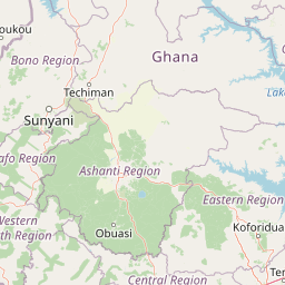
Map view of Sakumo Ramsar Site

Use this park location map to pinpoint Sakumo Ramsar Site in Ghana, understand its exact geographic position, and read its mapped placement within the surrounding landscape more clearly.

Pigeon | © OpenStreetMap contributors

Location context for Sakumo Ramsar Site

Greater Accra Region
Recorded earthquake history

View the Historical Earthquake Catalogue for the Sakumo Ramsar Site

Examine the historical record of seismic events associated with the Sakumo Ramsar Site. This curated collection on MoriAtlas displays documented earthquakes by date, magnitude, and distance to provide a clear view of recorded regional seismic activity near the protected coastal wetland.

Sakumo Ramsar Site Earthquake History

Catalogued events

6 events

Strongest magnitude

Magnitude 4.4

Most recent event

Jun 24, 2020

This history includes earthquakes recorded inside the park or within 50 km of its borders

Park atlas

Compare regional wetlands, coastal savanna reserves, and connected habitats

Explore Parks Near Sakumo Ramsar Site and Surrounding Coastal Protected Areas

Discover other protected areas near Sakumo Ramsar Site to compare regional wetland habitats and coastal conservation zones. Expanding the geographic view helps trace wider ecological networks and adjacent wildlife reserves across the surrounding landscape.
A horizontal watercolor painting showing a winding river flowing through a lush marshy landscape with distant hills in the background.
Nature reserveGreater Accra Region
25 km away#1 closest

West

Densu Delta Ramsar Site: Coastal Wetland Geography in the Greater Accra Region

Protected nature reserve, lagoon network, and tidal marshland

Located at the mouth of the Densu River, this Ramsar site features an interconnected system of mangroves, salt pans, and shallow lagoons. The protected area serves as an essential coastal buffer and bird habitat, showcasing the complex interplay between riverine freshwater and the marine environment of the Gulf of Guinea.

Area
58.93 km²
Established
1992
Water
Water-dominated
Wildlife reserveCentral Region
69 km away#2 closest

Southwest

Muni-Pomadze Ramsar Site: Protected Coastal Wetlands and Forest Reserves in Ghana

Coastal lagoons, mangrove stands, and undulating hill geography

Covering a compressed sequence of coastal and inland landforms, the Muni-Pomadze Ramsar Site serves as a significant protected landscape. This area encompasses the Muni Lagoon, shoreline dunes, and the forested slopes of the Yenku and Egyasimanku Hills, creating an ecologically diverse habitat that defines the geography of the surrounding coastline.

Area
3 km²
Established
1992
IUCN
II
A watercolor painting showing a soft, impressionistic landscape of Keta Lagoon, featuring patches of green vegetation, yellow grasses, and calm water against a light, airy background.
Protected areaVolta Region
About 98 km away#3 closest

East

Keta Lagoon Protected Area: Coastal Wetland Geography and Regional Landscape Mapping

A vital ecological and cultural landscape in Ghana's Volta Region

Keta Lagoon represents a primary coastal wetland system in eastern Ghana. Spanning the coastline between sandy barriers and inland floodplains, this protected area features a unique mosaic of mangroves, tidal flats, and islands. Its role as a major waterbird habitat and the center of Anlo-Ewe cultural life makes it a significant site for understanding West African coastal geography and environmental conservation.

Area
1,200 km²
Established
1992
Relief
Lowland
Climate
Tropical
Wildlife reserveVolta Region
About 106 km away#4 closest

Northeast

Kalakpa Game Production Reserve: Atlas Overview of Protected Terrain in Ghana

Ecological mosaic landscape in the Volta Region

Kalakpa Game Production Reserve represents a diverse protected area where Borassus and Combretum woodlands meet semi-deciduous gallery forests. Situated on the foothills of the Togo Mountains, this reserve provides essential habitat in the forest-savanna transition of southeastern Ghana, defined by its rugged rocky hills and seasonal valley streams.

Area
320 km²
Established
1975
IUCN
VI
Relief
Upland
National parkGhana
128 km away#5 closest

West

Kakum National Park: Ghana's Landmark Protected Rainforest and Canopy Walkway

Mapped tropical forest landscape and unique elevated park exploration.

Kakum National Park represents a significant protected area within Ghana, characterized by its 375 square kilometers of moist evergreen tropical rainforest. The park's identity is strongly linked to its iconic canopy walkway, an engineering feat offering elevated views into the forest structure. As a national park, Kakum provides crucial mapped context for understanding West African biodiversity and regional geography, including notable primate populations and the densest concentration of forest elephants in Ghana. Its community-driven establishment also marks it as a key site for participatory conservation examples.

Area
375 km²
Established
1992
IUCN
II
Visitors
135.9K annual
Wildlife reserveVolta Region
About 144 km away#6 closest

North

Tafi Atome Monkey Sanctuary: Mapping Ghana's Community Protected Wildlife Reserves

Protected sacred grove geography in the Volta Region

Tafi Atome Monkey Sanctuary preserves a unique tropical forest ecosystem that has been protected by local tradition for over two centuries. Located in the Volta Region of Ghana, this wildlife reserve demonstrates the significance of community-based conservation. View the sanctuary through the lens of its forest structure, primate populations, and the surrounding rural mosaic that makes this site a key element of the region's protected landscape.

Established
1993
Relief
Lowland
Climate
Tropical
Access
Access unknown
Wildlife reserveAshanti Region
About 182 km away#7 closest

Northwest

Bobiri Forest Reserve and Butterfly Sanctuary: Mapped Wildlife Reserve and Forest Geography

Ashanti Region protected landscape and butterfly habitat

Focusing on its status as a dedicated butterfly sanctuary, this protected forest reserve in Ghana offers a clear window into semi-deciduous ecology. Covering 54 square kilometers, the site is recognized for high insect biodiversity and its unique position as both an active research area and a managed wildlife reserve near the village of Kubease.

Area
54.65 km²
Established
1939
Relief
Upland
Climate
Tropical
Wildlife reserveGhana
About 194 km away#8 closest

Northwest

Bomfobiri Wildlife Sanctuary: Mapped Geography and Protected Landscapes in Central Ghana

A diverse habitat mosaic featuring forests, savanna, and waterfalls.

Bomfobiri Wildlife Sanctuary offers a compressed look at Ghana's natural diversity, where riverine corridors transition into open savanna. The protected area is recognized for its combination of dense forest, varied geological rock formations, and significant natural landmarks like the Lion Stone and local waterfalls, providing a clear perspective on the region's complex physical geography.

Area
53 km²
Established
1975

Common questions about visiting, size, designation, and location context for Sakumo Ramsar Site

Sakumo Ramsar Site FAQs for park facts, access, geography, and protected area context

Find quick answers about Sakumo Ramsar Site, including protected-area facts, park geography, trail and visitor context, and how the park fits into its surrounding country and regional landscape.
MoriAtlas Explorer

Continue Your Protected Areas Search Across the Global Atlas

Deepen your exploration by continuing the structured search for national parks and protected areas worldwide. Utilize the comprehensive filtering capabilities to compare different conservation landscapes and refine your understanding of global park geography. Discover more about the distribution and characteristics of protected natural areas.

Global natural geography