
Mori Atlas logo
Protected landscapeSaline Ulcinj

A vast mosaic of saline pools and mudflats forming a vital migratory bird sanctuary in coastal Montenegro.

Saline Ulcinj Protected Landscape: Understanding the Coastal Wetland Geography of the Buna Delta

Saline Ulcinj covers 1,500 hectares of the Buna river delta, featuring a distinctive landscape of engineered evaporation basins and narrow embankments that define its character as a coastal nature park. This protected area transforms through seasonal cycles of flooding and evaporation, creating a dynamic mosaic of shallow pools and white salt crusts. As a critical refuge along the eastern Adriatic flyway, the site functions as a complex wetland habitat that supports diverse avian communities and unique saline terrain.

saltworkssaline wetlandnature parkmigratory birdswaterbirdswaders
A flat vector illustration of a landscape with a central waterfall cascading into a valley, with salt pan pools in the foreground, wind turbines on a distant ridgeline, and trees lining the edges.

Saline Ulcinj

Protected landscape

Park overview

Structured park overview, official facts, and landscape profile for Saline Ulcinj

Saline Ulcinj park facts, protected area profile, and essential visitor context

Review the core facts for Saline Ulcinj, including designation, size, terrain, visitor scale, habitats, and operating context in one park-focused overview.

About Saline Ulcinj

Saline Ulcinj sits at the southern edge of Montenegro, within the low-lying coastal landscape formed by the Buna, otherwise Bojana, river as it approaches the Adriatic Sea. The site occupies a triangular wedge of reclaimed coastal terrain between the river, the sea, and the outskirts of Ulcinj. Although it is not a national park in the strict sense, it functions as a protected natural area whose ecological importance far exceeds its modest regional footprint.

The defining feature of Saline Ulcinj is its man-made hydrology. Originally engineered to extract sea salt, the saltworks consist of a network of basins, channels, and dikes that control the flow and evaporation of seawater. The same infrastructure, when managed for conservation rather than industry, produces a finely graduated wetland landscape, ranging from deep pools at one end of the hydrological sequence to nearly dry salt crusts at the other. This gradient of salinities and water depths is precisely what makes the site so attractive to birds.

A further element of the park's identity is its position within the Buna delta ecosystem, an area where freshwater inputs from river channels meet the saline influence of the Adriatic. The juxtaposition of salt pans, reed-fringed channels, and nearby coastal lagoons creates a varied habitat matrix that supports an exceptional density and diversity of birdlife. Within the broader Mediterranean, Saline Ulcinj is regarded as one of the more important sites for migratory and wintering waterbirds, and it is increasingly treated as a flagship example of how obsolete industrial landscapes can be repurposed for conservation.

Quick facts and research context for Saline Ulcinj

Saline Ulcinj lies within the Buna river delta near the southern Montenegrin coast, a short distance from the Albanian border. The site covers approximately 1,500 hectares and was one of the largest active salt-producing complexes of the former Yugoslavia during the mid twentieth century.

Following privatization in 2005 and the cessation of salt harvesting in 2013, the area has transitioned into a protected nature park, designated as such on 24 June 2019. Today it is recognized as a key node in the network of Mediterranean coastal wetlands supporting migratory waterbirds and shorebirds.

Park context

Deeper park guide and search-rich context for Saline Ulcinj

Saline Ulcinj history, landscape, wildlife, and travel context

Explore Saline Ulcinj through its history, landscape character, ecosystems, wildlife, conservation priorities, cultural context, and seasonal travel timing in a structured park guide built for atlas discovery and search intent.

Why Saline Ulcinj stands out

Saline Ulcinj is best known for its role as a staging, breeding, and wintering ground for migratory birds along the eastern Adriatic coast. The cycling of seawater through evaporation basins, originally designed for salt extraction, now produces a dynamic mosaic of saline pools, mudflats, and partially dry pans that offer ideal conditions for waders and waterbirds. Species such as spoonbills, greater flamingos, Dalmatian pelicans, ospreys, marsh harriers, and peregrine falcons regularly use the area. The park's combination of large size, traditional salt-pan hydrology, and geographic position within the Buna delta makes it one of the standout Mediterranean wetland complexes for bird conservation.
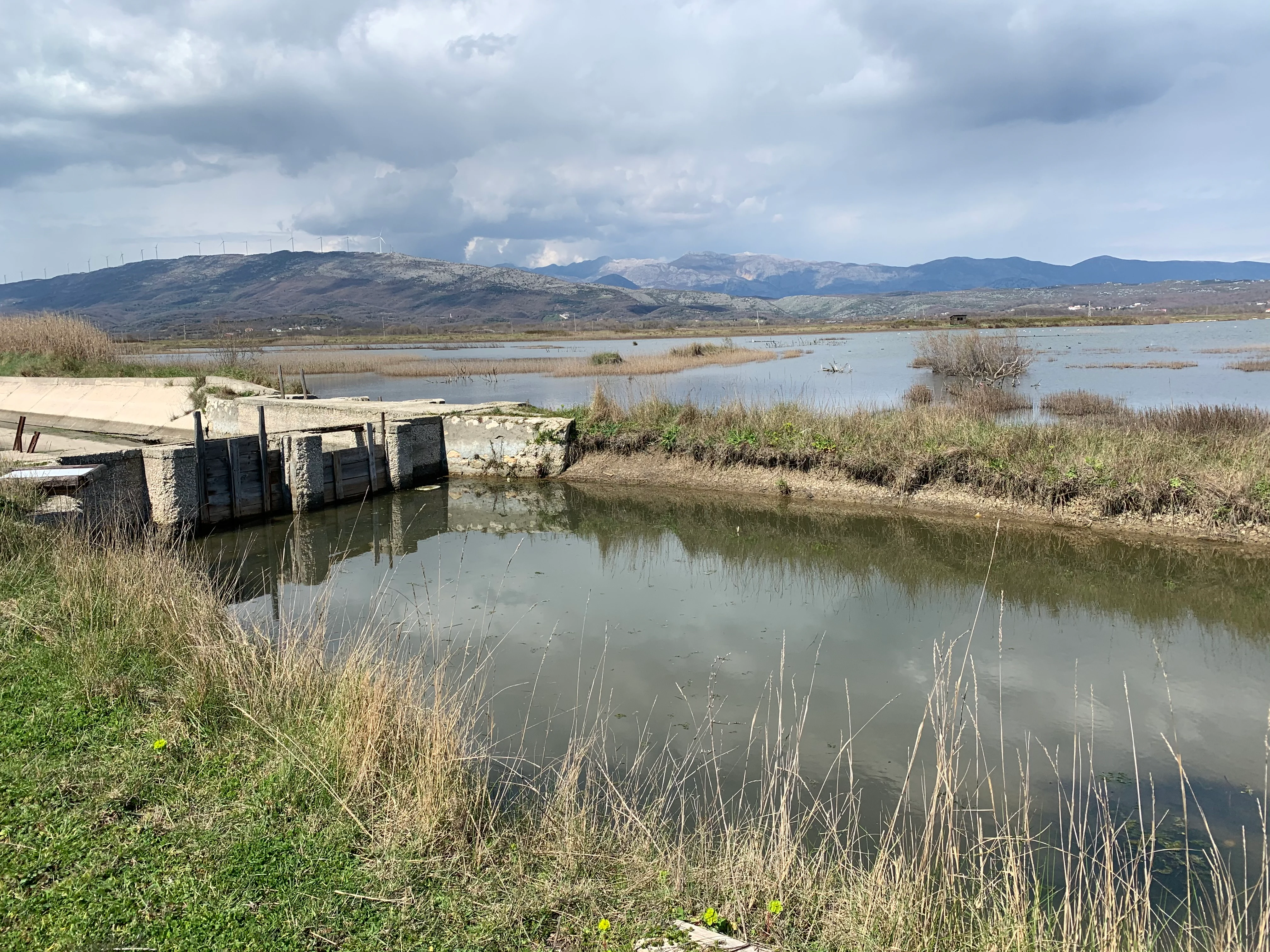
A calm, narrow water channel leading to a concrete structure in the foreground, with the wide, marshy expanse of the Saline Ulcinj salt pans and distant mountains under a cloudy sky in the background.
A water channel and concrete sluice structure in the Saline Ulcinj salt pans.

Saline Ulcinj history and protected-area timeline

The history of Saline Ulcinj is closely tied to the twentieth-century industrial development of the Yugoslav Adriatic coast. In 1920, a coastal lagoon called Zoganjsko Jezero, sometimes translated as the Lake of Birds, was identified as a suitable site for a new sea salt operation. Construction of the saltworks took place between 1926 and 1934, and commercial salt production began in 1935.

The facility expanded significantly after the Second World War. At its peak, around four hundred workers produced roughly 60,000 tonnes of salt per year, supplying about 60 percent of the salt needs of the former Yugoslavia. The saltworks were an important regional employer and an integral part of the coastal economy for several decades.

Privatization came in 2005. Production continued for a time, but in 2013 commercial salt harvesting was finally halted. Once the industrial activity ceased, NGOs that had been working to protect the site since 2003 were able to reshape its purpose. From 2015 onward, conservation organizations intensified efforts to secure Saline Ulcinj as a protected bird area, and in early 2024 the first phases of urgent ecological restoration work were completed. On 24 June 2019, the municipality of Ulcinj gave the site the formal status of a nature park, anchoring its future as a protected natural area.

Saline Ulcinj landscape and geographic character

The landscape of Saline Ulcinj is strongly shaped by human intervention, although its broader setting remains essentially coastal deltaic terrain. The site lies almost at sea level, framed by the meandering channels of the Buna delta to the east and the open Adriatic to the west. The dominant visual elements are the geometric outlines of evaporation basins, dividing dikes, and connecting water channels that together form a distinctive checkerboard pattern from the air.

At ground level, the terrain alternates between flooded pans, partially drained evaporation ponds, dry salt flats, and narrow access embankments. Depending on the season and the phase of the flooding cycle, visitors can encounter mirrors of still seawater one month and brilliant white salt crusts the next. The interplay of open water, saline mud, low dike walls, and distant coastal hills gives the park an unusual visual character, more reminiscent of a working landscape than a conventional wilderness, yet rich in ecological meaning.

To the north and east of the saltworks, the surrounding environment includes reed beds, freshwater channels of the Buna delta, and adjacent coastal lake systems such as Šasko Jezero, which broaden the effective habitat network around the reserve.
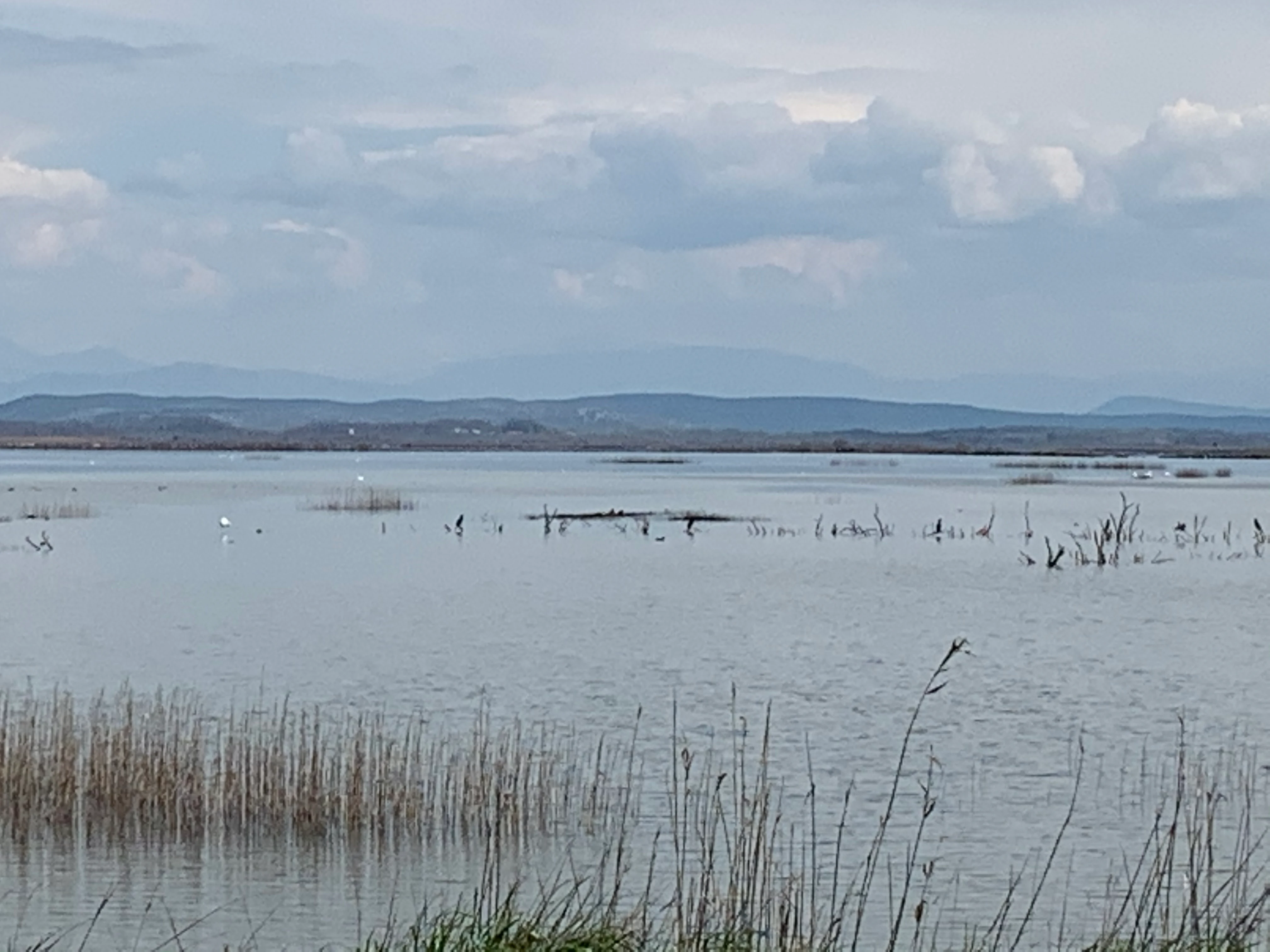
A wide shot of a calm, shallow salt pan wetland with scattered reeds and distant rolling hills under a cloudy sky.
A view across the wetland habitats at Saline Ulcinj.

Saline Ulcinj ecosystems, habitats, and plant life

Ecologically, Saline Ulcinj is best understood as a managed saline wetland complex. The salt pans themselves are the ecological core, but their value depends on a deliberate environmental rhythm: the basins are flooded with seawater early in the season and then allowed to evaporate gradually. This controlled hydrological cycle produces a shifting mosaic of open water, shallow brine pools, exposed mud, and dry saline crust.

Such a gradient of water depths and salinities is rare in the Mediterranean. Few habitats offer so many transitional conditions in such a compact area. The result is a site where different ecological niches, from submerged aquatic environments to hypersaline flats, coexist side by side and shift through the seasons. This variability supports a rich community of invertebrates and aquatic organisms, which in turn sustains dense populations of birds.

The park also intersects with the broader Buna delta landscape. Where the influence of the river meets the influence of the sea, transitional brackish and freshwater conditions complement the saline pans. Together, these features make Saline Ulcinj an unusually layered wetland system, with a strong identity rooted in salinity gradients rather than forest cover or mountainous terrain.
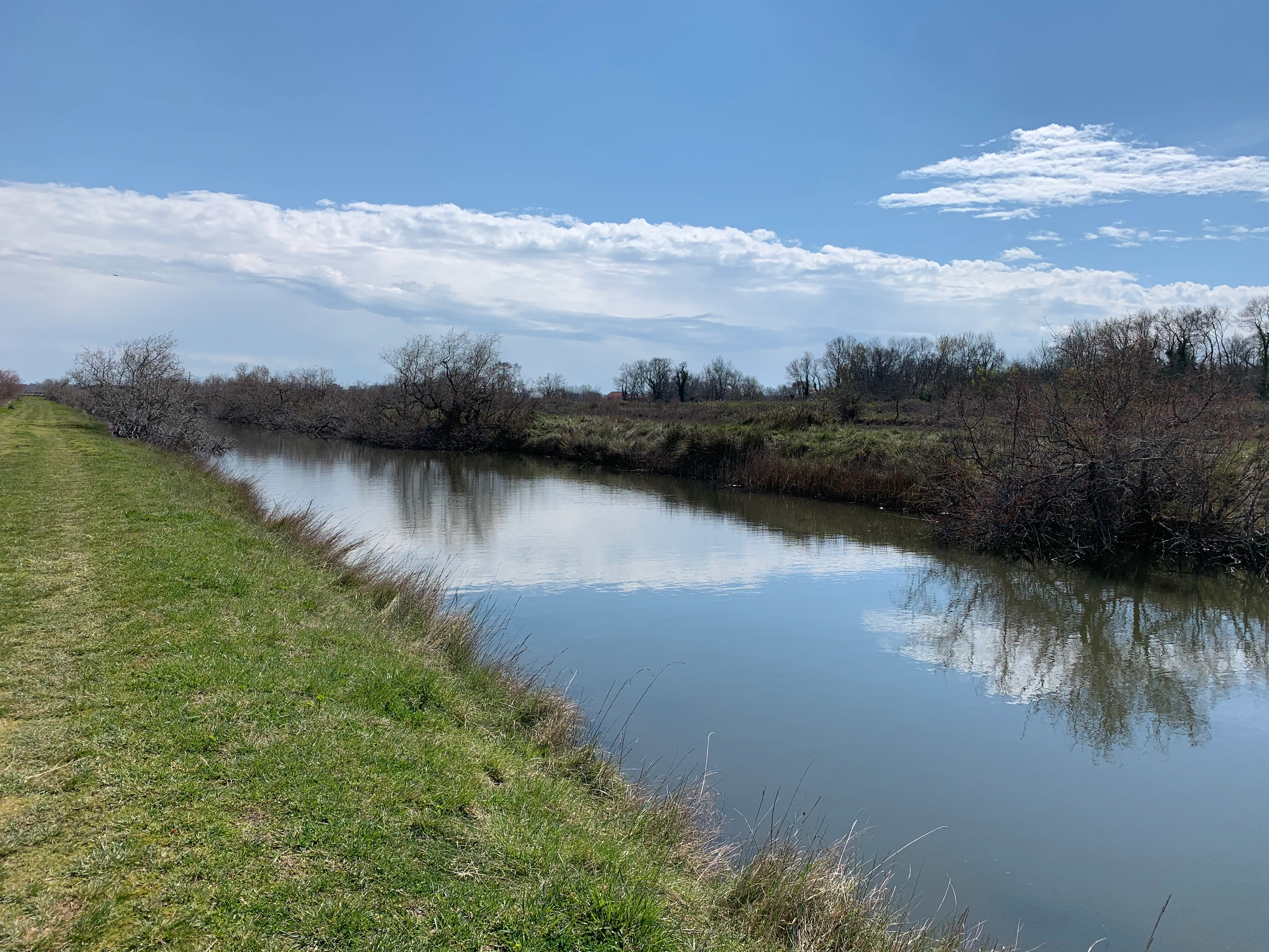
A calm, narrow canal reflecting the blue sky and clouds, bordered by a grassy bank on the left and scrubby, low vegetation on the right.
A calm canal winding through the wetland landscape of Saline Ulcinj in Montenegro.

Saline Ulcinj wildlife and species highlights

Saline Ulcinj is famous above all for its birdlife. The seasonal flooding cycle aligns with the migration, breeding, and wintering calendars of many species that follow the eastern Adriatic flyway. The site regularly hosts spoonbills, greater flamingos, and Dalmatian pelicans, all of which depend on the shallow saline waters and abundant invertebrate prey.

Birds of prey are also characteristic of the site. Ospreys, honey buzzards, lesser kestrels, black kites, marsh harriers, short-toed snake eagles, and peregrine falcons use the area at different times of the year, attracted by the concentrations of smaller birds and fish. The reed edges and dry margins of the pans also support passerines such as corn buntings and woodlarks, contributing to the overall diversity of the bird community.

Beyond birds, the salt pans host specialized communities of salt-tolerant invertebrates and aquatic life adapted to fluctuating salinity levels. The park is therefore not only a refuge for charismatic species but also a habitat for less conspicuous organisms whose presence explains why the site is so attractive to birds in the first place.

Saline Ulcinj conservation status and protection priorities

The conservation significance of Saline Ulcinj lies in its size, its hydrological complexity, and its strategic position along a major bird migration corridor. Few wetland sites of comparable scale exist along the eastern Adriatic shore, and the loss of industrial salt production unexpectedly opened a path for far stronger ecological protection.

Since 2003, non-governmental organizations have worked to preserve the area as a refuge for migratory, breeding, and wintering birds. Their efforts were reinforced in 2019 when the municipality of Ulcinj formally designated the site as a nature park. After the cessation of salt production in 2013, restoration measures focused on repairing dikes, channels, and water-control structures so that the flooding cycle could be maintained for ecological rather than industrial purposes. By early 2024, the first urgent restoration phases had been completed, marking a significant step in transforming the site into a functioning wetland reserve.

The park's conservation importance is widely regarded as extending beyond Montenegro. Within the Mediterranean basin, it represents one of the most significant examples of a former saltworks successfully converted into a protected wetland, contributing to regional networks aimed at safeguarding migratory birds and coastal lagoon systems.

Saline Ulcinj cultural meaning and human context

Saline Ulcinj carries an unusual blend of industrial and natural heritage. The salt pans themselves reflect a long Mediterranean tradition of coastal salt extraction, an activity that has shaped the southern Adriatic coastline for centuries. Communities along the Montenegrin coast have historically depended on fishing, salt-making, and trade, and the saltworks were for a time a central element of local employment and regional identity.

The transition from a working saltworks to a nature park represents a more recent cultural shift in how coastal communities relate to their landscape. Local recognition of the site's ecological value, alongside growing regional awareness of migratory bird conservation, has begun to redefine Ulcinj's southern shore as a place of natural heritage as much as industrial heritage. The coexistence of nearby traditional settlements, the Buna delta landscape, and adjacent coastal lakes such as Šasko Jezero reinforces this sense of layered, working coastal identity rather than untouched wilderness.

Top sights and standout views in Saline Ulcinj

Saline Ulcinj stands out for the sheer scale of its saline wetland system, the unusual ecological richness produced by its engineered flooding cycle, and its importance as a stopover for migratory birds. The combination of flamingos, pelicans, spoonbills, and a wide community of raptors makes it one of the most rewarding birdwatching sites in the eastern Adriatic.

The park also offers a striking visual landscape of geometric evaporation basins, sea-bright salt crusts, and quiet channels, framed by the soft outlines of the Buna delta and the distant Adriatic horizon. Its identity as a former industrial site reborn as a nature reserve gives it a distinctive and compelling character among Mediterranean protected areas.

Best time to visit Saline Ulcinj

The character of Saline Ulcinj shifts significantly through the year, and the timing of a visit largely determines what visitors can expect to see. The most rewarding periods for birdwatching are generally spring, when migratory species are moving northward, and autumn, when southbound migration brings diverse waders, waterbirds, and raptors to the basins.

Winter is also important ecologically, as the site serves as a refuge for waterbirds that remain in the Mediterranean during colder months, and the dried salt flats and lower water levels expose large areas of open ground and salt crust. Summer tends to be quieter for visitors but can showcase the extreme evaporation phase of the pans, when the basins appear as bright white salt landscapes. The cycling of flooding and drying means that even within a single season the visual and ecological atmosphere of the park can change markedly.
Monthly climate preview

Long term average temperature and precipitation rhythm across the park coordinate

Saline Ulcinj Climate Normals and Representative Monthly Temperature Patterns

Saline Ulcinj records sustained monthly temperature variations alongside measured precipitation patterns derived from representative coordinate sampling between 1991 and 2020. Examining the complete twelve month climate profile reveals detailed shifts in average minimum and maximum thresholds across the protected area.
Annual mean15 °C
6 °C26 °C
Jan
Feb
Mar10°
Apr13°
May18°
Jun23°
Jul26°
Aug26°
Sep21°
Oct17°
Nov12°
Dec
Warmest month
August

26.2 °C

Coolest month
January

5.9 °C

Wettest month
November

5.4 mm/day

Driest month
July

1.1 mm/day

Park location guide

Geography guide, regional context, and park location map for Saline Ulcinj

Saline Ulcinj park geography, regions, and map view in Montenegro

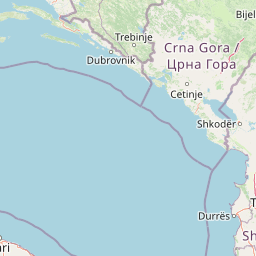
Understand where Saline Ulcinj sits in Montenegro through a broader geographic reading of the surrounding landscape, nearby location context, and its mapped position within the national park landscape.

How Saline Ulcinj fits into Montenegro

Montenegro is a unitary parliamentary republic in Southeast Europe on the Balkan Peninsula. With a population of approximately 623,000 and an area of 13,883 km², it borders five countries and has a coastline on the Adriatic Sea. The capital and largest city is Podgorica, while Cetinje serves as the old royal capital. The country declared independence in 2006 following the breakup of Serbia and Montenegro.

Wider geography shaping Saline Ulcinj in Montenegro

Montenegro is located on the Balkan Peninsula in Southeast Europe. It is bordered by Serbia to the northeast, Bosnia and Herzegovina to the northwest, Kosovo to the east, Albania to the southeast, and Croatia to the west. The country has a coastline along the Adriatic Sea to the southwest. The terrain is predominantly mountainous, with the Dinaric Alps running through the country.

Map view of Saline Ulcinj

Use this park location map to pinpoint Saline Ulcinj in Montenegro, understand its exact geographic position, and read its mapped placement within the surrounding landscape more clearly.

Pigeon | © OpenStreetMap contributors

Location context for Saline Ulcinj

Ulcinj

Explore the unique terrain, geometric salt pans, and protected wildlife habitats of Montenegro.

Saline Ulcinj Photos and Landscape Scenery: Visualizing the Coastal Wetland Environment

Visual records reveal the complex interplay of shallow evaporation pools, muddy flats, and engineered dikes that define the terrain of Saline Ulcinj. Examining these protected area views provides a clearer understanding of how former industrial saltworks function as vital Adriatic wetland habitats.

A calm, narrow water channel leading to a concrete structure in the foreground, with the wide, marshy expanse of the Saline Ulcinj salt pans and distant mountains under a cloudy sky in the background.

A wide view of the dry, brown salt pan fields at Saline Ulcinj, with wooden stake borders and low hills topped with wind turbines in the distance under a cloudy sky.

A wide shot of a calm, shallow salt pan wetland with scattered reeds and distant rolling hills under a cloudy sky.

A calm, narrow canal reflecting the blue sky and clouds, bordered by a grassy bank on the left and scrubby, low vegetation on the right.

Park atlas

Compare adjacent wetland habitats and regional coastal landscapes

Parks Near Saline Ulcinj and Surrounding Protected Areas

Explore other parks and protected areas near Saline Ulcinj to compare coastal wetland networks and deltaic terrain across the region. Extending the geographic scope reveals connected wildlife refuges and broader ecological patterns along the eastern Adriatic flyway.
A horizontal watercolor painting of a serene river landscape with green trees on both banks and small boats floating on the water at sunset.
Protected landscapeShkodër County
About 13 km away#1 closest

East

Buna River-Velipojë Protected Landscape: Albania Coastal and Wetland Geography

Mapped protected landscape in Shkodër County

The Buna River-Velipojë Protected Landscape encompasses the crucial junction of riverine systems and the Adriatic Sea. This protected area features a mosaic of marshes, lagoons, and alluvial forests that form a significant migratory corridor in northwestern Albania.

Area
230.27 km²
Established
2005
IUCN
V
Relief
Lowland
A watercolor painting showing a panoramic view of green rolling hills and a body of water under a soft, light sky.
Nature reserveShkodër District
About 23 km away#2 closest

Northeast

Lake Shkodër Nature Reserve: Mapping Protected Wetland and Riverine Geography in Albania

A critical Balkan freshwater protected area.

The Lake Shkodër Nature Reserve serves as a foundational protected landscape in northern Albania, encompassing the extensive shoreline and riverine floodplains of Lake Skadar. This geographic entity showcases a transition from fertile lowlands to mountainous ridges, offering a detailed look at how hydrologic processes and alpine proximity define Balkan wetland habitats.

Area
265.35 km²
Established
2005
IUCN
IV
Relief
Lowland
Watercolor painting of a lake landscape with green marshes in the foreground, small islands in the middle, and rolling hills in the background.
National parkMontenegro
About 27 km away#3 closest

North

Lake Skadar National Park: An Atlas Overview of Montenegro's Largest Freshwater Wetland

Karst Terrain and Transboundary Protected Landscapes

Lake Skadar stands as a monumental geographic feature in Montenegro, serving as the largest lake in Southern Europe. This national park protects a diverse ecosystem ranging from submerged karst springs to expansive seasonal marshes. Its status as a transboundary system offers insights into Mediterranean hydrology and endemic freshwater biodiversity within the unique Balkan karst basin.

Area
450 km²
Established
1983
Relief
Lowland
Climate
Mediterranean
A minimalist watercolor painting depicting a soft-focus landscape with green marshes, pale yellow flats, and light pink rolling hills in the background.
Nature reserveLezhë County
About 32 km away#4 closest

Southeast

Kunë-Vain-Talë-Patok-Fushëkuqe-Ishëm Nature Park: Mapped Geography and Coastal Wetlands

Protected lagoon and forest landscapes in Lezhë County, Albania

Examine the protected territory of Kunë-Vain-Talë-Patok-Fushëkuqe-Ishëm Nature Park, defined by its dynamic lagoon systems, alluvial forests, and coastal dunes along the Adriatic shore. This area provides deep insight into deltaic hydrology and the preservation of Mediterranean woodland habitats within a regional geographic context.

Area
43.93 km²
Established
2010
IUCN
IV
Relief
Lowland
Watercolor painting showing a mountainous landscape with a lake, green hills, and pink flowers
National parkAlbania
About 48 km away#5 closest

Northeast

Alps of Albania National Park: Explore Albania's Largest Protected Alpine Wilderness

Dramatic karst, glacial valleys, and high-altitude ecosystems await.

The Alps of Albania National Park offers an expansive view into one of the Balkans' most significant mountain protected areas. This national park encompasses a spectacular landscape characterized by towering limestone peaks, deep glacial valleys carved over millennia, and intricate karst formations like Grunas Canyon. Its pristine wilderness protects diverse high-altitude ecosystems and unique geological features, serving as a key destination for understanding regional geography and protected landscapes.

Area
828.447 km²
Established
2022
IUCN
II
Relief
Mountain
A watercolor painting showing a soft, panoramic landscape of low hills, green fields, and water, with a light and ethereal style.
Protected areaMontenegro
About 48 km away#6 closest

North

Cijevna Protected Area: Mapping the River Canyon and Balkan Highlands Geography

An alpine river system spanning the Montenegro and Albania border

The Cijevna represents a striking natural corridor carved into the Prokletije mountains. This protected landscape is defined by its deep V-shaped valleys, high-altitude gorges, and seasonal discharge patterns that sustain important freshwater biodiversity across the Balkan highlands.

A minimalist watercolor painting showing a tranquil lake surrounded by gentle hills and trees against a soft, pale sky.
Nature reserveDibër County
About 55 km away#7 closest

Southeast

Lake Ulza Nature Park: Mapped Geography and Protected Area Overview in Dibër County

Analyzing the reservoir and river valley landscapes of central Albania

Lake Ulza Nature Park represents a significant protected mosaic where the Mat River creates a corridor of reservoirs, oak forests, and stony uplands. This overview examines the park geography, offering a structured look at how water bodies and mountainous terrain converge to form a unique inland habitat in Dibër County. Explore the physical relief and environmental boundaries that define this essential Albanian natural landmark.

Area
42.06 km²
Established
2013
IUCN
IV
Relief
Mixed relief
Nature reserveAlbania
About 65 km away#8 closest

Southeast

Shtamë Pass Nature Park: Geographic Overview and Protected Mountain Landscape Map

Highland pine forests and freshwater corridors in Albania

Shtamë Pass Nature Park sits within the central Albanian mountains, providing a critical ecological link between coastal-inland gateway regions. The area protects a complex mosaic of alpine terrain, including clear mountain lakes, cold freshwater springs, and dense black pine forests that shelter brown bears and wolves. This protected zone offers a comprehensive view of regional highland geography and topography through its distinct mountain pass corridor.

Area
68.64 km²
Established
1996
IUCN
IV

Common questions about visiting, size, designation, and location context for Saline Ulcinj

Saline Ulcinj FAQs for park facts, access, geography, and protected area context

Find quick answers about Saline Ulcinj, including protected-area facts, park geography, trail and visitor context, and how the park fits into its surrounding country and regional landscape.
MoriAtlas Explorer

Continue Your Protected Areas Search Across the Global Atlas

Deepen your exploration by continuing the structured search for national parks and protected areas worldwide. Utilize the comprehensive filtering capabilities to compare different conservation landscapes and refine your understanding of global park geography. Discover more about the distribution and characteristics of protected natural areas.

Global natural geography