
Mori Atlas logo
Nature reserveSande am Tannenbusch bei Kleinlangheim

Mapping sand habitats, forest margins, and avian corridors in the Steigerwaldvorland

Sande am Tannenbusch bei Kleinlangheim Nature Reserve and Regional Protected Landscapes

(Naturschutzgebiet Sande am Tannenbusch bei Kleinlangheim)

Sande am Tannenbusch bei Kleinlangheim represents a vital protected mosaic in the Steigerwaldvorland of Lower Franconia. This nature reserve protects a distinctive inland sand landscape, including rare sand-poor grasslands and heath communities that contrast sharply with the surrounding Klosterforst woodland. Beyond its botanical value, the area serves as a significant distribution center for the ortolan bunting, integrating diverse wetland patches, meadows, and forest edges into a compact ecological unit.

sand grasslandsand heathinland dunesforest edge habitatsnature reserveLower Franconia
A graphic illustration of a mountainous landscape with a waterfall flowing down a cliffside, surrounded by coniferous trees and rows of vegetation in the foreground.

Sande am Tannenbusch bei Kleinlangheim

Nature reserve

Park overview

Structured park overview, official facts, and landscape profile for Sande am Tannenbusch bei Kleinlangheim

Sande am Tannenbusch bei Kleinlangheim park facts, protected area profile, and essential visitor context

Review the core facts for Sande am Tannenbusch bei Kleinlangheim, including designation, size, terrain, visitor scale, habitats, and operating context in one park-focused overview.

About Sande am Tannenbusch bei Kleinlangheim

Sande am Tannenbusch bei Kleinlangheim is a compact Lower Franconian nature reserve that protects one of the characteristic inland sand habitat mosaics of the Steigerwaldvorland, the foothill landscape that transitions from the Main valley up toward the Steigerwald. Although it lies within the larger Klosterforst forest area between the villages of Kleinlangheim and Haidt, the reserve is not primarily a forest conservation site. Instead, the Tannenbusch forest gives the area its name and forms a structural backdrop, while the actual conservation focus lies on the open and semi-open habitats along the forest edges and in clearings.

Geologically, the reserve belongs to the Albertshofener Flugsandgebiet, a region shaped by ancient sand deposits that have produced nutrient-poor, drought-prone soils. These conditions have allowed the development of sand-magerrasen and sandgrasheide habitats, dry grassland communities of high botanical value that have become rare across northern Bavaria due to land-use changes. The reserve's two main sections are connected by a narrow strip of woodland, and the southern part gives rise to the Rodenbach, a small stream that flows into the River Main.

In ecological terms, the area is defined less by a single habitat type than by a tightly interlocking mosaic of dry sandy substrates, moist pockets, meadows, and forest margins. This fine-grained habitat diversity supports a rich invertebrate and bird fauna, and lies at the core of the reserve's conservation value. The site is bordered in the south by the now-disused Kitzingen-Schweinfurt railway line and nearly reaches the Bundesautobahn 3 in the north, making it a small but ecologically meaningful patch within a heavily managed regional landscape.

Quick facts and research context for Sande am Tannenbusch bei Kleinlangheim

Sande am Tannenbusch bei Kleinlangheim is a nature reserve (Naturschutzgebiet) in Lower Franconia, Bavaria, located on the territory of the municipality of Kleinlangheim in the Landkreis Kitzingen. It was formally designated by the government of Unterfranken on 30 June 1995 and falls under IUCN Category IV, a habitat and species management area.

The reserve covers approximately 38 hectares, a figure that is also reflected in its parallel designation as a Fauna-Flora-Habitat (FFH) area and within the surrounding Südliches Steigerwaldvorland bird protection zone. Its protected-area identifier in the German national register is NSG-00498.01, and in the World Database on Protected Areas its WDPA ID is 165303.

Protection and recognition

Documented terrestrial protection scope and international recognition records for Sande am Tannenbusch bei Kleinlangheim

Sande am Tannenbusch bei Kleinlangheim Protection Status and Recognized Designations

Sande am Tannenbusch bei Kleinlangheim maintains a documented terrestrial protection scope within the global database framework. Official records compile verified designation metrics and international recognition sources to support structured park research.

Protection details

Protection scope
Terrestrial
Transboundary protection
No
WDPA ID
165303
Park context

Deeper park guide and search-rich context for Sande am Tannenbusch bei Kleinlangheim

Sande am Tannenbusch bei Kleinlangheim history, landscape, wildlife, and travel context

Explore Sande am Tannenbusch bei Kleinlangheim through its history, landscape character, ecosystems, wildlife, conservation priorities, cultural context, and seasonal travel timing in a structured park guide built for atlas discovery and search intent.

Why Sande am Tannenbusch bei Kleinlangheim stands out

The reserve is best known for protecting a rare mosaic of sand-magerrasen (sand-poor grassland) and sandgrasheide (sand grass heath) habitats typical of the Albertshofener Flugsandgebiet inland sand landscape. Beyond its botanical importance, the site is regionally recognized as one of the most important Bavarian strongholds of the ortolan (Emberiza hortulana), a farmland bird whose population has declined sharply across much of central Europe. The combination of dry sand openings, meadows, forest edges, and small wetland patches in close proximity makes the reserve a notable example of small-scale habitat diversity in the Steigerwaldvorland.
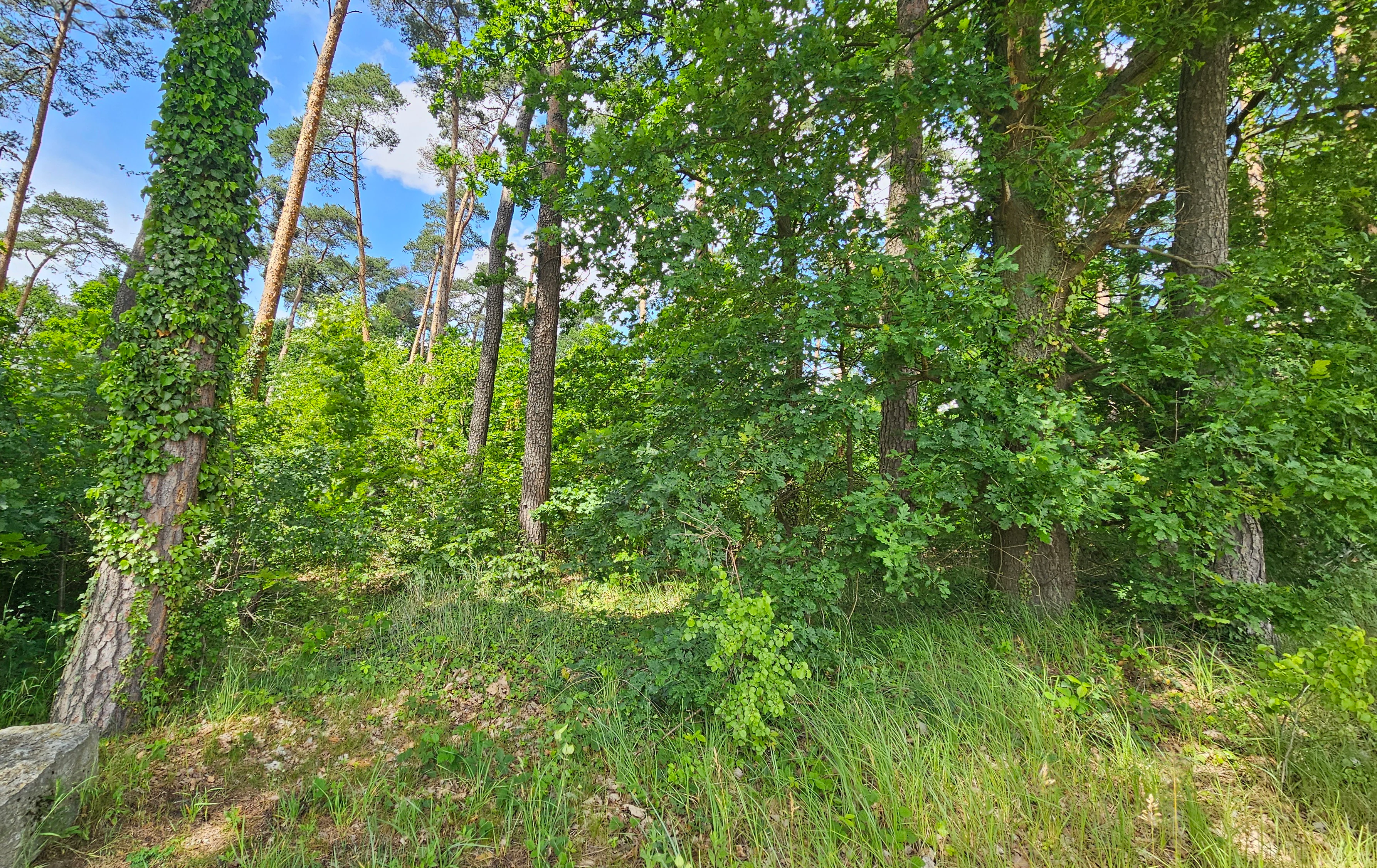
A dense patch of forest with tall green trees, undergrowth, and ivy-covered tree trunks under a partially cloudy blue sky.
A view into the lush woodland of the Sande am Tannenbusch nature reserve.

Sande am Tannenbusch bei Kleinlangheim history and protected-area timeline

The protected area was formally established by ordinance (Verordnung) of the government of Unterfranken on 30 June 1995, creating the Naturschutzgebiet Sande am Tannenbusch bei Kleinlangheim as an IUCN Category IV habitat and species management area.

Its designation reflects long-standing recognition of the region's unusual inland sand habitats around the Albertshofener Flugsandgebiet and the broader Steigerwaldvorland. The forested setting within the Klosterforst had historically been managed as woodland, but conservation interest in this period shifted toward the open sand habitats, forest edges, and adjacent waldnahe areas that the new reserve was designed to safeguard. A further important step came with the area's inclusion in the EU-wide Natura 2000 network, where the characteristic habitat mosaic was incorporated into the FFH area Sandgebiete bei Schwarzach, Klein- und Großlangheim.

Sande am Tannenbusch bei Kleinlangheim landscape and geographic character

Sande am Tannenbusch bei Kleinlangheim occupies a gently undulating position within the Steigerwaldvorland, the broad transitional landscape between the Main valley and the higher Steigerwald uplands in Lower Franconia.

The reserve's underlying character is defined by sandy substrates, a legacy of the Albertshofener Flugsandgebiet, which have produced open, dry terrain that contrasts with the surrounding farmland and forest. The protected area comprises two main sections linked by a thin belt of woodland, giving the site a slightly fragmented footprint. The southern portion of the reserve is the source of the Rodenbach, a small tributary of the River Main whose course helps shape the local drainage and supports moist microhabitats amid the otherwise dry sand soils.

The supporting forest belongs to the Klosterforst, a large, historically managed woodland complex in the Kitzingen district. While the wooded interior of the Tannenbusch gives the site its name, the actual conservation interest lies in the transitions: sun-exposed forest margins, sandy clearings, and adjoining meadows. The southern boundary is defined by the now-closed Kitzingen-Schweinfurt railway, while the northern edge approaches the busy Bundesautobahn 3, framing the reserve within a noticeably human-influenced landscape.

Sande am Tannenbusch bei Kleinlangheim ecosystems, habitats, and plant life

The reserve's biotope complex is anchored by sandmagerrasen and sandgrasheiden, dry, species-rich grassland communities that thrive on the nutrient-poor, acidic inland sands of the Albertshofener Flugsandgebiet. These habitats support characteristic specialist flora of the region's sand landscape and have become a conservation priority because they depend on continuing low-intensity land management.

What distinguishes the site ecologically is the close interconnection of contrasting habitats. Dry sandy openings are interspersed with moist patches, small wetland areas, meadows, and forest edges, creating a fine-grained mosaic within a compact footprint. This juxtaposition of xeric and mesic conditions within a short distance supports a higher diversity of invertebrates and ground-nesting birds than any single habitat type would on its own.

The forest itself, part of the wider Klosterforst, plays a supporting role rather than being the main focus. It frames the open habitats, provides shelter and perches for woodland and edge species, and links the two main sections of the reserve through the narrow wooded corridor between them. The combination of these elements is what allows the site to function as an FFH area as well as a national nature reserve.

Sande am Tannenbusch bei Kleinlangheim wildlife and species highlights

Birdlife is the most conspicuous ecological asset of the reserve. The entire area lies within the Südliches Steigerwaldvorland bird protection zone, and its mosaic of field, edge, and open sand habitats supports a diverse community of breeding and migrating species.

The site's most notable ornithological feature is its role as one of the main Bavarian strongholds of the ortolan (Emberiza hortulana), a farmland and edge species that has suffered major declines across much of central Europe. Beyond the ortolan, many other protected and noteworthy resident and migratory birds regularly use the area, drawn by the combination of open sandy ground, low vegetation, meadows, and adjacent woodland.

The reserve's mix of dry sand, wet ground, and forest-margin habitats also supports a varied invertebrate fauna typical of inland sand ecosystems, which in turn underpins the food supply for ground-foraging birds. Although the site is small, the structural diversity of habitats gives it a disproportionately rich wildlife profile relative to its size.

Sande am Tannenbusch bei Kleinlangheim conservation status and protection priorities

The reserve was specifically created to protect a group of increasingly threatened habitat types: sandmagerrasen and sandgrasheiden associated with the inland sand landscapes around the Albertshofener Flugsandgebiet. These communities are highly sensitive to changes in land use, nutrient input, and shrub encroachment, and have become conservation priorities within the Lower Franconian and Bavarian protected-area network.

Its status as an IUCN Category IV site underlines that management, not just strict preservation, is central to its purpose. The explicit protection goals include both the conservation of the dry sandy habitats and the safeguarding of threatened plant and animal species that depend on the broader habitat mosaic of dry, moist, and wooded patches. By also being part of the FFH area Sandgebiete bei Schwarzach, Klein- und Großlangheim, the reserve is integrated into the EU-wide Natura 2000 framework, reinforcing its role in pan-European habitat conservation.

Sande am Tannenbusch bei Kleinlangheim cultural meaning and human context

The reserve sits within a landscape shaped by centuries of woodland management and monastic landholding. The surrounding Klosterforst takes its name from the historical monastic forest administration associated with the region's former abbeys, and the forest remains a defining element of local identity in the Kitzingen district.

The village of Kleinlangheim, on whose municipal territory the reserve lies, and the neighboring Haidt area give the reserve its name and connect it to a long-established rural community pattern in Lower Franconia. The now-disused Kitzingen-Schweinfurt railway, which forms part of the southern boundary, also marks a layer of 19th- and 20th-century transport history running through the Steigerwaldvorland. Together these features place the reserve within a working cultural landscape rather than a remote wilderness setting.

Top sights and standout views in Sande am Tannenbusch bei Kleinlangheim

A defining highlight of the reserve is the rare coincidence of sand-magerrasen and sandgrasheide communities within a compact, formally protected area, set against the broader Albertshofener inland sand landscape. Equally notable is the site's dual designation as both a national Naturschutzgebiet and a Natura 2000 FFH area, tying local protection to European habitat conservation priorities.

The reserve's ornithological profile is another strong highlight: it acts as a Bavarian center of distribution for the ortolan and supports a varied community of migratory and resident birds in a very small footprint. The visual contrast between the open sandy habitats and the surrounding Klosterforst woodland, together with the small Rodenbach spring in the southern part of the reserve, gives the site a particularly expressive micro-landscape for those exploring the Steigerwaldvorland.

Best time to visit Sande am Tannenbusch bei Kleinlangheim

The reserve is most rewarding in late spring and early summer, when the open sand-magerrasen and sandgrasheide communities are in active growth and their characteristic flora is most visible. This is also the period when breeding birds, including the ortolan, are most active along the forest edges and open sandy ground, making it the strongest season for birdwatching.

Late summer and early autumn can still provide good sightings of post-breeding and migrant birds using the habitat mosaic, while the surrounding woodland and forest margins of the Klosterforst take on more visual prominence in the cooler months. Because the reserve is a small protected site embedded in working agricultural and infrastructural surroundings, visiting in mild, settled weather tends to give the best experience of its open sandy habitats.


Monthly climate preview

Long-term annual temperature and precipitation progression profiles

Sande am Tannenbusch bei Kleinlangheim Climate and Temperature Normals

Sande am Tannenbusch bei Kleinlangheim records measured monthly temperature variations and consistent precipitation rates across a representative coordinate elevation of 293.66 meters. Detailed examination of the complete twelve-month climate normals reveals precise long-term averages for thermal maximums and minimums.
Annual mean9 °C
-1 °C20 °C
Jan-1°
Feb
Mar
Apr
May13°
Jun17°
Jul20°
Aug19°
Sep15°
Oct
Nov
Dec
Warmest month
July

19.7 °C

Coolest month
January

-0.7 °C

Wettest month
July

2.4 mm/day

Driest month
April

1.3 mm/day

Park location guide

Geography guide, regional context, and park location map for Sande am Tannenbusch bei Kleinlangheim

Sande am Tannenbusch bei Kleinlangheim park geography, regions, and map view in Germany

Understand where Sande am Tannenbusch bei Kleinlangheim sits in Germany through a broader geographic reading of the surrounding landscape, nearby location context, and its mapped position within the national park landscape.

How Sande am Tannenbusch bei Kleinlangheim fits into Germany

Germany is a federal republic in Western and Central Europe with a population of over 83 million across sixteen constituent states. It is Europe's largest economy by nominal GDP and a major global exporter and importer. The capital is Berlin, and the country borders Denmark, Poland, Czech Republic, Austria, Switzerland, France, Luxembourg, Belgium, and the Netherlands.

Wider geography shaping Sande am Tannenbusch bei Kleinlangheim in Germany

Germany is located in Western and Central Europe, spanning 357,022 km². It borders Denmark to the north, Poland and the Czech Republic to the east, Austria and Switzerland to the south, and France, Luxembourg, Belgium, and the Netherlands to the west. The country has coastlines on the Baltic Sea and North Sea to the north, with the Alps located in the southern region.

Map view of Sande am Tannenbusch bei Kleinlangheim

Use this park location map to pinpoint Sande am Tannenbusch bei Kleinlangheim in Germany, understand its exact geographic position, and read its mapped placement within the surrounding landscape more clearly.

Pigeon | © OpenStreetMap contributors

Location context for Sande am Tannenbusch bei Kleinlangheim

Unterfranken

Visual reference of rare inland sand habitats and forest edge terrain

Sande am Tannenbusch bei Kleinlangheim Photos: Landscapes and Scenery

Visual records illustrate the rare mosaic of dry sand grassland and open heath environments across Sande am Tannenbusch bei Kleinlangheim. Detailed photography captures the distinct terrain transitions and protected landscape features within the Steigerwaldvorland.

A dense patch of forest with tall green trees, undergrowth, and ivy-covered tree trunks under a partially cloudy blue sky.

A wide view of a sloping vineyard in the foreground leading toward a meadow and a dense line of trees in the background under a soft light.

Park atlas

Compare surrounding Lower Franconia nature reserves and inland sand habitats.

Parks Near Sande am Tannenbusch bei Kleinlangheim and Related Protected Landscapes

Browsing other protected areas near Sande am Tannenbusch bei Kleinlangheim reveals the diverse inland sand topography of the Steigerwaldvorland. Extending the geographic comparison uncovers connected regional habitats and broader conservation zones across Lower Franconia.
Watercolor painting of a green forested landscape with soft rolling hills in the background.
Nature reserveBavaria
About 2.9 km away#1 closest

West

Naturwald Schwarzacher Tännig: Protected Oak Forest and Regional Landscape Context

Natural forest reserve in the Steigerwaldvorland of Bavaria

Naturwald Schwarzacher Tännig stands as a dedicated nature reserve in Bavaria, focused on the preservation of old-growth oak habitats. By removing this state forest area from active timber production, the reserve supports essential natural regeneration and structural biodiversity. The site functions as a key element within the regional ecological network of the Steigerwald foothills, illustrating the importance of small protected areas for maintaining diverse lowland forest habitats.

Area
0.095 km²
Established
2021
Relief
Upland
Scope
Terrestrial
A watercolor painting of a gentle landscape showing grassy plains, distant rolling hills, and patches of trees.
Nature reserveBayern
About 5.4 km away#2 closest

North

Sandfluren bei Volkach, Schwarzach am Main und Sommerach: Protected Sand Habitats

Inland dune formations and xerothermic grasslands in Bayern

Located in the Main valley, this nature reserve is defined by its inland sand dunes and drift sand flats that provide a refuge for specialized flora and fauna. As a designated Geotop and Natura 2000 site, it offers a distinct study of arid habitats surviving within an agricultural landscape. Explore the geographic boundaries and terrain mosaic that make this protected area a noteworthy feature of the Lower Franconian environment.

Area
1.048 km²
Established
1989
IUCN
IV
A watercolor illustration depicting a soft, rolling landscape of green hills, distant mountain silhouettes, and a winding stream.
Protected areaBavaria
About 9.3 km away#3 closest

Southeast

Naturwald Speckfeld: Protected Forest Reserve and Steigerwald Geographic Detail

Broadleaf woodland and gypsum ridge landscapes in Bavaria

Naturwald Speckfeld offers a look into unharvested forest dynamics within the Steigerwald mountains. This protected area stands out for its steep topography, historical castle ruins, and rare broadleaf woodland transitions, providing a critical reference point for natural forest conservation in the Lower Franconia region of Bavaria.

Area
0.195 km²
Established
1978
Relief
Upland
Climate
Temperate
Watercolor painting showing rolling green hills, trees in the midground, and purple-tinted mountains in the background against a white backdrop.
Nature reservePrichsenstadt
About 12 km away#4 closest

Northeast

Naturwald Krackentännig Nature Reserve: A Protected Forest Landscape in Northern Bavaria

Geography of the Steigerwaldvorland and Gänsseegraben valley floor

Situated near Prichsenstadt, Naturwald Krackentännig acts as a refuge for ash and alder trees that thrive in the moist soils of the Lower Franconian countryside. This nature reserve provides a critical example of undisturbed forest development, showcasing a specialized ecosystem within the rolling hills of the Steigerwaldvorland and a commitment to preserving small-scale woodland habitats.

Area
0.026 km²
Established
2021
Relief
Lowland
Scope
Terrestrial
A soft, light watercolor painting of a pastoral landscape with rolling green fields, scattered trees, and distant hills under a pale yellow sky.
Nature reserveBavaria
About 13 km away#5 closest

Northwest

Sandgrasheiden am Elgersheimer Hof Nature Reserve and Main Valley Protected Landscapes

Rare sand grassland geography and conservation status in Lower Franconia, Bavaria

Sandgrasheiden am Elgersheimer Hof protects two distinct parcels of sand grassland, a rare habitat type that provides a refuge for specialized plant communities like Jurinea cyanoides. Situated within the Maintal between Schweinfurt and Dettelbach, the reserve creates a critical ecological link between agricultural plains and riverine meadow landscapes. This atlas entry details the geographic context and habitat mosaic of this significant Bavarian nature reserve.

Area
0.035 km²
Established
1999
IUCN
IV
Watercolor painting of a forest landscape with a grassy clearing and distant hills, rendered in soft green and pink tones.
Nature reserveGermany
About 18 km away#6 closest

Northeast

Naturwald Waldhaus: Geographic Mapping of an Ancient Beech Reserve in Steigerwald, Bavaria

Protected natural woodland and forest biodiversity in northern Germany.

Naturwald Waldhaus stands as a prime example of a protected forest in the Steigerwald, recognized for its exceptionally old beech stands and documented saproxylic beetle populations. This nature reserve provides essential ecological continuity within the Bamberg district, representing a rare, undisturbed woodland landscape that serves as a cornerstone for forest research in southern Germany.

Area
1.062 km²
Established
1978
Relief
Upland
Climate
Temperate
A horizontal watercolor painting showing a soft, layered forest landscape with coniferous trees in the foreground and rolling mountains in the distance.
Nature reserveGermany
About 23 km away#7 closest

North

Naturwaldreservat Riedholz: Protected Woodland and Floodplain Forest in Lower Franconia

Mapped natural forest reserves in the Steigerwaldvorland region

Naturwaldreservat Riedholz represents a pioneering municipal initiative in Bavaria to preserve lowland forest processes permanently. Located near Grettstadt and Schwebheim, this protected woodland preserves moisture-loving vegetation and relict oaks, acting as a vital ecological anchor within the agricultural landscape of the Schweinfurt Basin.

Area
0.11 km²
Established
1999
Relief
Lowland
Scope
Terrestrial
A watercolor painting showing a panoramic landscape with light green hills, tall slender trees in the foreground, and soft washes of color depicting a natural forest scene.
Nature reserveBavaria
About 24 km away#8 closest

East

Naturwald Schlag Nature Reserve: Geographic Atlas and Protected Forest Context in Bavaria

A dedicated site for natural forest development and regional conservation mapping

Naturwald Schlag serves as a vital case study for non-intervention forestry in the Steigerwald region of Upper Franconia. Located near the locality of Heuchelheim, this reserve protects a mature stand of pine, beech, and oak. MoriAtlas provides a clear view of its formal designation and geographic position within the broader Bavarian natural forest network.

Area
0.008 km²
Established
2021
Relief
Upland
Climate
Temperate

Common questions about visiting, size, designation, and location context for Sande am Tannenbusch bei Kleinlangheim

Sande am Tannenbusch bei Kleinlangheim FAQs for park facts, access, geography, and protected area context

Find quick answers about Sande am Tannenbusch bei Kleinlangheim, including protected-area facts, park geography, trail and visitor context, and how the park fits into its surrounding country and regional landscape.
MoriAtlas Explorer

Continue Your Protected Areas Search Across the Global Atlas

Deepen your exploration by continuing the structured search for national parks and protected areas worldwide. Utilize the comprehensive filtering capabilities to compare different conservation landscapes and refine your understanding of global park geography. Discover more about the distribution and characteristics of protected natural areas.

Global natural geography