
Mori Atlas logo
Nature reserveSandgrube im Jagen 86

A former sand quarry transformed into a diverse habitat mosaic of dry grasslands and wetlands

Sandgrube im Jagen 86 Nature Reserve: Mapped Protected Landscapes in Berlin Germany

(Naturschutzgebiet Sandgrube im Jagen 86 des Grunewaldes)

Sandgrube im Jagen 86 represents a significant protected area within the Berlin Grunewald forest, originating from an industrial sand quarry that reached depths of 25 meters. This nature reserve now sustains an unusual ecological contrast by housing bare sand flats, shallow groundwater-fed pools, and damp willow carrs in a compact 18 hectare footprint. The site serves as a crucial refuge for warm-loving invertebrates, ground-nesting bees, and diverse amphibians that rely on these carefully managed sandy and wetland habitats.

nature reserveIUCN Category IVurban nature reserveformer sand quarrysand habitatdry grassland
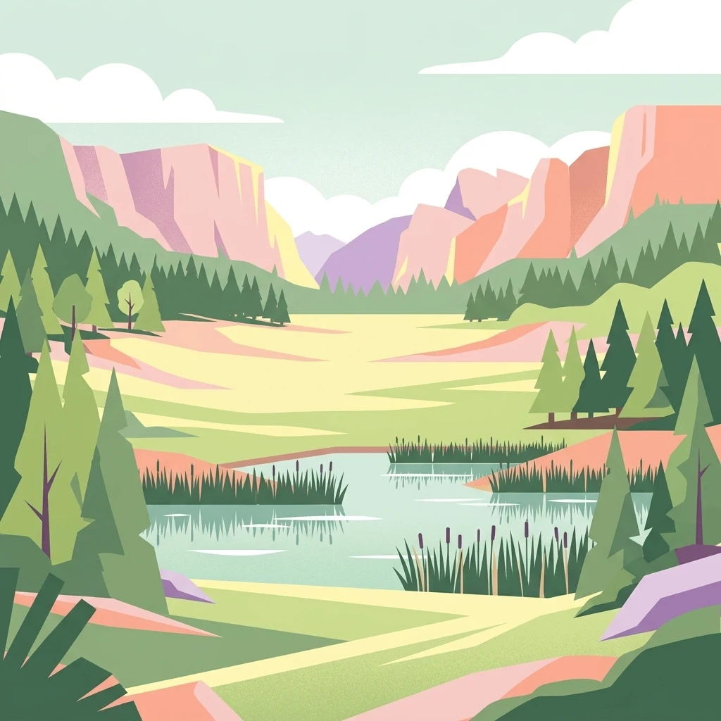
A flat-design illustration of a nature scene featuring a central pond surrounded by grassy meadows, evergreen trees, and distant rocky canyon walls under a pale sky.

Sandgrube im Jagen 86

Nature reserve

Park overview

Structured park overview, official facts, and landscape profile for Sandgrube im Jagen 86

Sandgrube im Jagen 86 park facts, protected area profile, and essential visitor context

Review the core facts for Sandgrube im Jagen 86, including designation, size, terrain, visitor scale, habitats, and operating context in one park-focused overview.

About Sandgrube im Jagen 86

Set within the Grunewald, the substantial forested area that defines western Berlin, Sandgrube im Jagen 86 occupies a distinctive niche in the city's network of protected areas. Although it covers only about 13.5 hectares, the reserve packages an unusually complete cross-section of habitat types into a single accessible site, making it an important reference point for urban nature conservation in Germany.

The Grunewald itself is one of Berlin's largest continuous woodland landscapes, and the quarry stands as a contrasting open wound in that forest canopy, a basin where the surrounding woodland has been deliberately allowed to retreat in order to preserve open sand and wetland habitats. This contrast is not incidental. The reserve exists precisely because industrial sand extraction, which ran from 1966 to 1983, removed roughly 3.5 million cubic meters of fine sand from a Weichselian-era geological formation and left behind a pit reaching 25 meters at its deepest. Once pumping and excavation stopped, the high water table of the region filled the lower parts of the pit, creating a layered environment where dry sand vegetation and aquatic habitats meet almost edge to edge.

Visitors encounter vegetation-free sandy flats, dry and nutrient-poor grassland, wet willow scrub, and clear shallow pools supporting amphibian breeding, along with vegetation that has been intentionally kept low through clearance work to prevent reforestation of the slopes. Fencing and visitor pathways separate the most sensitive zones, particularly nests and breeding areas for ground-nesting bees and wasps, while three information panels orient visitors to the quarry's history, the wetland, and the reserve's distinctive fauna. Access is provided via the Schildhornweg and reinforced by ramps at the northern and southern edges and a 134-step staircase at the northeastern corner.

Quick facts and research context for Sandgrube im Jagen 86

Sandgrube im Jagen 86 is a designated nature reserve of approximately 13.5 hectares situated in the Grunewald, the large forested district of Berlin. The site lies within the Teltow plateau geological region, shaped during the Weichselian glaciation, and was originally created through industrial extraction of fine sand for construction.

It is identified as NSG-13 in Berlin's nature protection register, is catalogued in the World Database on Protected Areas as record 165311, and is classified internationally as an IUCN Category IV protected area, recognizing its role in targeted habitat and species management. The reserve combines open sand surfaces, dry and nutrient-poor grassland, shallow wetland, and willow carrs, supporting diverse flora and fauna despite its compact size.

Protection and recognition

Analysis of terrestrial protected area records, management framework, and international recognition data

Sandgrube im Jagen 86 Protection Status and Documented Conservation Scope

Sandgrube im Jagen 86 maintains a documented terrestrial protection status within official databases without recorded international designation sources. Reviewing these verified administrative records provides clear insight into the governance framework governing the protected landscape.

Protection details

Protection scope
Terrestrial
Transboundary protection
No
WDPA ID
165311
Park context

Deeper park guide and search-rich context for Sandgrube im Jagen 86

Sandgrube im Jagen 86 history, landscape, wildlife, and travel context

Explore Sandgrube im Jagen 86 through its history, landscape character, ecosystems, wildlife, conservation priorities, cultural context, and seasonal travel timing in a structured park guide built for atlas discovery and search intent.

Why Sandgrube im Jagen 86 stands out

The reserve is best known for the striking ecological contrast it creates within a major city forest: a former sand quarry that now balances near-sterile sand flats against shallow standing water, damp willow carrs, and dry heath-like grassland, all in immediate proximity to each other. This compact, sharply defined mosaic favors species that have become rare elsewhere in intensively used landscapes, including ground-nesting wild bees and wasps, amphibians breeding in nutrient-poor pools, and warm-loving invertebrates whose populations are actively maintained by keeping south-facing slopes clear of forest succession.
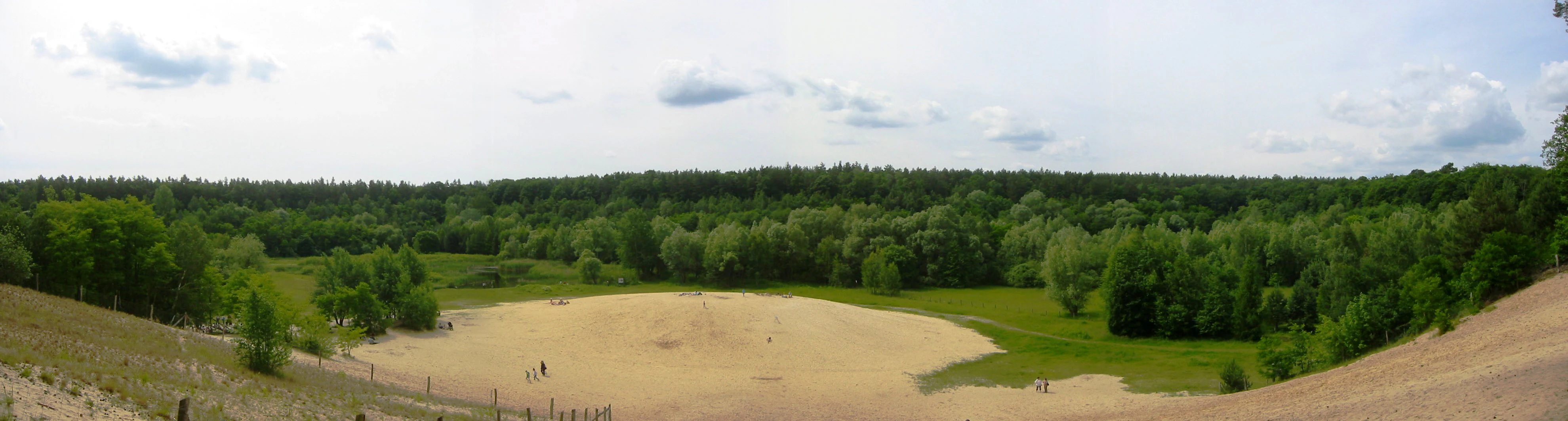
Panoramic landscape view of a former sand pit featuring a central sandy clearing surrounded by green vegetation and a dense forest line under a partly cloudy sky.
Panoramic view of the nature reserve at Sandgrube im Jagen 86, showing the transition from sandy pit to green wetland and forest.

Sandgrube im Jagen 86 history and protected-area timeline

Sandgrube im Jagen 86 has its origins in industrial activity rather than conservation. Between 1966 and 1983, fine construction sand was extracted from the Teltow plateau, a glacial landscape formed during the Weichselian cold period. Over the seventeen years of operation, about 3.5 million cubic meters of sand were removed for building purposes, leaving behind an excavated basin of roughly 18 hectares and up to 25 meters deep.

When extraction ended, conservation advocates campaigned to secure the site because nature had already begun to occupy the new open ground. In February 1992, the Berlin Senate formally designated 13 hectares of the former quarry as the nature protection area Sandgrube im Jagen 86, registered locally as NSG-13 and subsequently catalogued internationally in the World Database on Protected Areas. Since then, the reserve has been actively managed, including the clearing of encroaching trees and shrubs from the slopes to maintain the dry, sun-exposed open conditions that matter for ground-nesting insects and heat-loving fauna.

Sandgrube im Jagen 86 landscape and geographic character

The landscape of Sandgrube im Jagen 86 reads as a small-scale topographic anomaly in the middle of the Grunewald. A bowl-shaped quarry pit, up to 25 meters deep and reaching around 18 hectares at its historical maximum footprint, opens into the surrounding forest and exposes the underlying glacial sands of the Teltow plateau.

Inside the basin the terrain is clearly two-tiered. The lower, wetter levels fill with shallow groundwater-fed waterbodies, damp depressions, and willow carr along the margins. The higher and more exposed parts of the pit floor and the surrounding slopes form a dry, sandy landscape with bare sand flats, short grassland, and nutrient-poor, low-vegetation zones that resemble steppe-like heath. South-facing slopes in particular are maintained as open ground, which gives the reserve a warm, sun-exposed microclimate unusual for central Berlin.
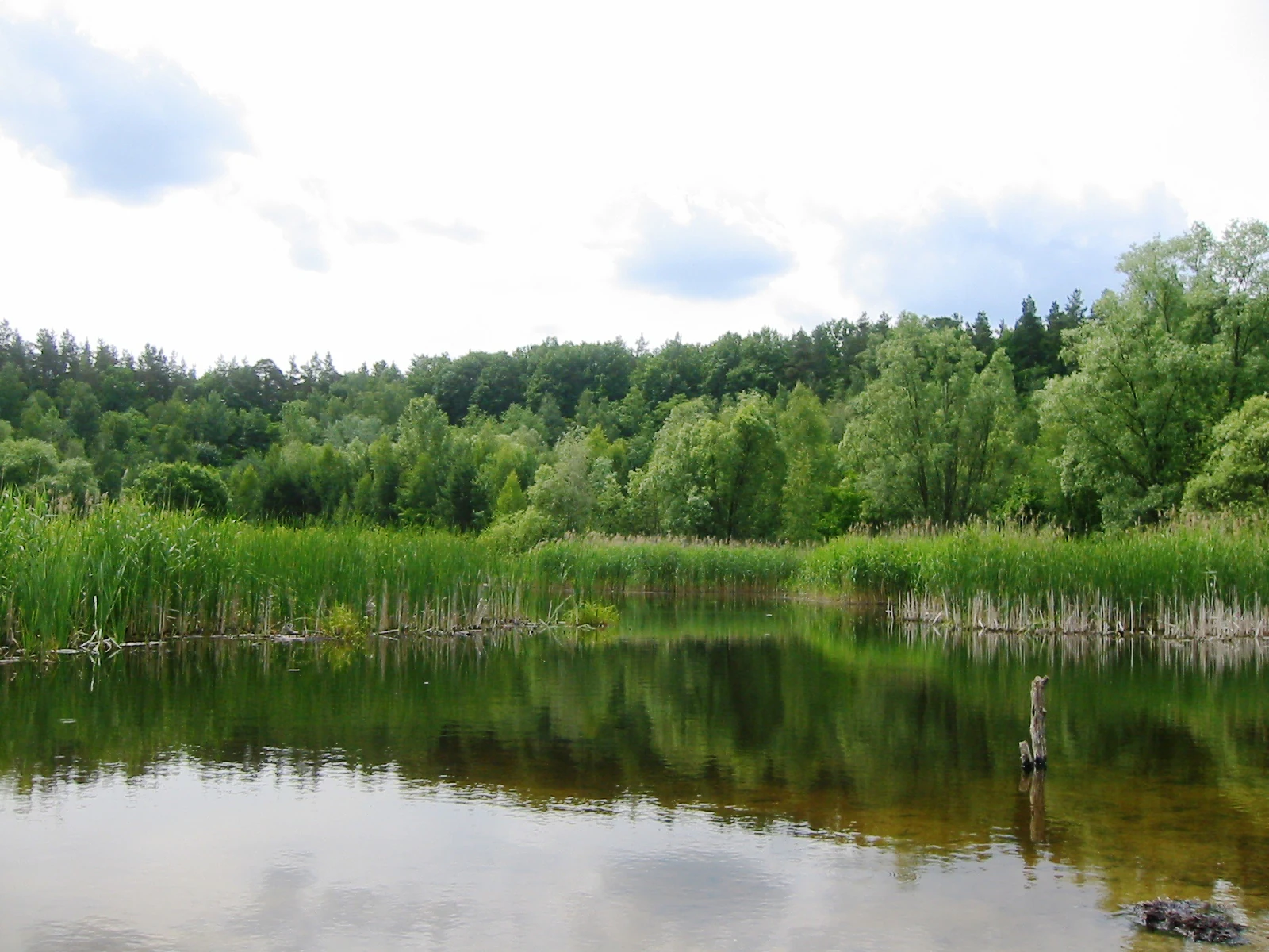
A calm, still pond surrounded by dense green reeds and a lush deciduous forest in the background under a cloudy sky.
The wetland biotope within the former sand pit of Sandgrube im Jagen 86.

Sandgrube im Jagen 86 ecosystems, habitats, and plant life

The ecological character of Sandgrube im Jagen 86 is defined by the close proximity of dry and wet habitats. On the dry side, the reserve includes bare sand surfaces, pioneer vegetation, dry grassland, and nutrient-poor meadows that mimic habitats once widespread across the Berlin region but now rare. On the wet side, the shallow waters and the marshy fringes support willow carr and seasonal pools ideal for amphibian reproduction.

This juxtaposition produces a particularly high density of plant species for such a small area: more than 300 ferns and flowering plants have been recorded in the reserve. Many of these are adapted to either extreme sand conditions or wet, nutrient-poor substrates, and the result is a flora that mixes heathland, meadow, wetland, and ruderal elements that would not normally coexist in a single continuous forest stand.

Sandgrube im Jagen 86 wildlife and species highlights

Wildlife is one of the reserve's main attractions. Seven amphibian species use the nutrient-poor pools as breeding habitat, where their larvae can develop in water largely free of competing fish. Sixteen bird species are documented as breeding within or directly around the quarry, using the mix of open sand, scrub, and forest edge for nesting and foraging.

The reserve is also a major stronghold for invertebrates. Around 188 butterfly species have been recorded, alongside significant populations of wild bees and wasps, many of which nest directly on the ground in bare sand. Fencing around key sections of the reserve protects these ground-nesting insects from trampling while still allowing visitors to walk through the broader site. The warm microclimate of the south-facing slopes is particularly important for these heat-loving species.

Sandgrube im Jagen 86 conservation status and protection priorities

Sandgrube im Jagen 86 is classified as an IUCN Category IV protected area, a designation reserved for sites where active management is essential to maintain targeted habitats and species. The reserve functions as a habitat refuge within the Grunewald, protecting a combination of dry sand, heath-like grassland, and wetland communities that have largely disappeared from the intensively used Berlin landscape.

Its conservation work is not passive. Management activities include the regular removal of woody vegetation to prevent the slopes from being reforested, the protection of bare sand surfaces for ground-nesting bees and wasps, and the maintenance of water levels suitable for amphibians. The reserve's inclusion in Berlin's formal nature protection system, its status under the German federal nature protection framework, and its record in the World Database on Protected Areas underline its recognition as a site of genuine ecological significance rather than a casual local green space.

Sandgrube im Jagen 86 cultural meaning and human context

The reserve has no deep pre-industrial cultural narrative; its identity is closely tied to twentieth-century Berlin, when the Grunewald was still actively mined for construction materials. The quarry years, running from 1966 to 1983, are an integral part of the site's story and a reminder that the Grunewald, often perceived as a purely natural landscape, has long been shaped by human resource use.

Since 1992, the site has also become a small piece of local environmental culture: a place where Berliners can encounter genuinely rare habitats without leaving the city, framed by explanatory panels developed with the Berlin Senate administration. Names like Kiesgrube (gravel pit) and Jagen 86, the latter being a traditional forestry compartment designation from the German forestry tradition, reflect the intertwined industrial and ecological history of this corner of the Grunewald.

Top sights and standout views in Sandgrube im Jagen 86

The most distinctive quality of Sandgrube im Jagen 86 is how completely a small, formerly industrial site can host a layered habitat mosaic: bare sand flats, dry nutrient-poor grassland, willow wetland, and open shallow water within a single accessible Berlin location.

It is also notable for the density of specialist species it supports, particularly ground-nesting bees and wasps, a rich assemblage of butterflies, and amphibians breeding in fish-free pools, all maintained through deliberate, ongoing habitat management rather than passive protection.

Best time to visit Sandgrube im Jagen 86

Because the reserve's biological value is centered on exposed sand, dry grassland, and breeding waterbodies, late spring through early autumn is generally the most rewarding period to visit. Warmer months bring out the butterflies, bees, and wasps that depend on the open sandy surfaces and sun-exposed slopes, while amphibian breeding activity is concentrated in the wetter early-season months.

The dry summer period also makes the terrain easier to walk through and highlights the contrast between the bare sand patches and the surrounding Grunewald forest. In winter, the site is quieter and more exposed, but the structural contrast between the open pit and the wooded surroundings remains clearly visible.

Monthly climate preview

Long-term representative point measurements tracking monthly temperature ranges and daily precipitation patterns

Sandgrube im Jagen 86 Climate Normals, Annual Temperature, and Precipitation Rhythm

Representative coordinate records show average monthly temperatures swinging from sub-zero winter minimums to warm summer highs alongside steady daily precipitation rates. Examining the full twelve-month profile provides complete historical climate data for this protected area.
Annual mean9 °C
-1 °C20 °C
Jan-1°
Feb
Mar
Apr
May14°
Jun18°
Jul20°
Aug20°
Sep15°
Oct
Nov
Dec
Warmest month
July

20.3 °C

Coolest month
January

-0.7 °C

Wettest month
July

2.4 mm/day

Driest month
April

1 mm/day

Park location guide

Geography guide, regional context, and park location map for Sandgrube im Jagen 86

Sandgrube im Jagen 86 park geography, regions, and map view in Germany

Understand where Sandgrube im Jagen 86 sits in Germany through a broader geographic reading of the surrounding landscape, nearby location context, and its mapped position within the national park landscape.

How Sandgrube im Jagen 86 fits into Germany

Germany is a federal republic in Western and Central Europe with a population of over 83 million across sixteen constituent states. It is Europe's largest economy by nominal GDP and a major global exporter and importer. The capital is Berlin, and the country borders Denmark, Poland, Czech Republic, Austria, Switzerland, France, Luxembourg, Belgium, and the Netherlands.

Wider geography shaping Sandgrube im Jagen 86 in Germany

Germany is located in Western and Central Europe, spanning 357,022 km². It borders Denmark to the north, Poland and the Czech Republic to the east, Austria and Switzerland to the south, and France, Luxembourg, Belgium, and the Netherlands to the west. The country has coastlines on the Baltic Sea and North Sea to the north, with the Alps located in the southern region.

Map view of Sandgrube im Jagen 86

Use this park location map to pinpoint Sandgrube im Jagen 86 in Germany, understand its exact geographic position, and read its mapped placement within the surrounding landscape more clearly.

Pigeon | © OpenStreetMap contributors

Location context for Sandgrube im Jagen 86

Berlin

Visualizing the habitats, terrain, and protected-area character of this Grunewald nature reserve

Sandgrube im Jagen 86 Photos and Landscape Scenery

Photographic records reveal the distinct topographic features and habitat mosaic defining Sandgrube im Jagen 86. Visual exploration of the terrain helps clarify the ecological contrast between exposed sand flats and wetland depressions.

Panoramic landscape view of a former sand pit featuring a central sandy clearing surrounded by green vegetation and a dense forest line under a partly cloudy sky.

An outdoor educational information sign in German with the title Grubengewässer und feuchte Senken, featuring photographs of a blue frog, a bird, a dragonfly, and a drawing of a snake.

A calm, still pond surrounded by dense green reeds and a lush deciduous forest in the background under a cloudy sky.

Park atlas

Compare regional park geography and connected conservation areas across the surrounding territory.

Parks Near Sandgrube im Jagen 86 and Surrounding Protected Landscapes

Browse other parks near Sandgrube im Jagen 86 to examine adjacent forest habitats and protected wetland reserves. Continued comparison of regional terrain reveals broader ecological patterns across the surrounding landscape.
A watercolor painting showing a soft green marshy landscape with low hills in the background and a winding stream in the foreground.
Nature reserveBerlin
About 2.2 km away#1 closest

Southeast

Hundekehlefenn Nature Reserve: Geography and Protected Wetland Landscapes in Berlin

Glacial meltwater channel and moorland in Grunewald

Hundekehlefenn represents one of the last surviving pieces of original Berlin vegetation, preserved as a nature reserve within the city limits. This compact protected area showcases a glacial meltwater channel geography, featuring marshy depressions, mesotrophic bog remnants, and alder swamp forests. It serves as an essential ecological link within the Grunewaldseenkette lake chain, providing a window into the natural terrain history of the region.

Area
0.1 km²
Established
1987
Relief
Lowland
Climate
Temperate
A horizontal watercolor painting showing a wetland landscape with calm water, marshy vegetation, and a background of soft rolling hills and mixed forest trees.
Nature reserveBerlin
About 3.2 km away#2 closest

South

Langes Luch / Dachsheide: Nature Reserve and Glacial Wetland Geography in Berlin

Protected mosaic of bog, forest, and inland dune habitats

Langes Luch / Dachsheide encompasses a rare urban protected area in Berlin, defined by the interplay between low-lying swampy depressions and elevated sandy heath. The site features complex glacial meltwater channels, open transitional mires, and historical terrain modifications, forming an essential study area for local conservation and regional landscape ecology.

Area
0.324 km²
Established
1960
IUCN
IV
Relief
Lowland
Nature reserveBerlin
About 3.3 km away#3 closest

North

Fließwiese Ruhleben: A Glacial Nature Reserve and Wetland Mosaic in Berlin

Mapping a unique urban protected area and its peat marsh topography

Fließwiese Ruhleben is a protected nature reserve in western Berlin that preserves a distinct relic of Weichselian glaciation. The site features a narrow, basin-like depression carved by glacial meltwater, supporting a rich diversity of peat-forming marshland and alder swamp forests. This protected area remains a vital node for regional biodiversity, contrasting sharply with the surrounding urban landscape of the Teltow plateau.

Area
0.118 km²
Established
1959
Relief
Lowland
Climate
Temperate
Nature reserveBerlin
About 3.7 km away#4 closest

South

Riemeisterfenn Nature Reserve and Protected Peatland Landscape in Berlin

A rare bog ecosystem within the city glacial lake chain

Riemeisterfenn is a distinct nature reserve in Berlin, characterized by its marshy lowlands, reed beds, and alder carr vegetation. This site offers an essential look at a preserved peatland habitat and the Fennkanal hydrology that connects these protected areas to the wider Grunewald forest ecosystem.

Area
0.072 km²
Established
1987
Relief
Lowland
Climate
Temperate
Protected landscapeBerlin
About 3.7 km away#5 closest

Northwest

Tiefwerder-Wiesen Protected Landscape: Berlin Riverine Geography and Floodplain Map

Mapping the historic Havel river floodplains and wetland habitats.

Tiefwerder-Wiesen serves as an important ecological corridor in Berlin, safeguarding the last functional pike spawning grounds within the city. This protected landscape contains a dense network of river arms, ditches, and sedge meadows that illustrate the historical and ongoing geomorphological processes of the Havel river valley.

Area
0.667 km²
Established
1960
Relief
Lowland
Climate
Temperate
Nature reserveBerlin
About 4.1 km away#6 closest

West

Windmühlenberg Nature Reserve: Glacial Terrain and Steppe Flora in Berlin

Protected sand-dry grasslands on the Nauen Plateau edge

Windmühlenberg preserves a rare ecological landscape in western Berlin. This glacial hill and nature reserve functions as a protected habitat for steppe-relict flora and specialized insects, serving as a critical point of interest for understanding the geomorphology and sand-based grassland environments of the Havel river valley.

Area
0.051 km²
Established
2002
Relief
Upland
Climate
Temperate
A soft watercolor painting showing rolling green hills, patches of open land, and trees against a pale sky background.
Nature reserveHavelland
About 9.5 km away#7 closest

West

Döberitzer Heide Nature Reserve: Geographic Atlas and Protected Landscape Mapping

Glacial sand flats and heathlands in the Havelland region

Döberitzer Heide occupies a unique position on the southeastern Nauener Platte, providing a study of dry heath, grassland, and wetland habitats. Once a restricted military training ground, the area now functions as a vital protected landscape where European bison and wild horses maintain open terrains. This atlas entry focuses on the regional geography and the structural components of this nature reserve situated near the urban centers of Berlin and Potsdam.

Area
34.15 km²
Established
1997
Relief
Upland
Climate
Temperate
A horizontal watercolor illustration depicting a calm lake surrounded by soft green forest and distant hazy hills.
Protected areaBerlin
About 11 km away#8 closest

Southwest

EU-Vogelschutzgebiet Westlicher Düppeler Forst: Protected Area and Regional Geography

Ecological sanctuary and Havel lakeshore landscape in Berlin

Located in the Steglitz-Zehlendorf district, this protected area spans nearly 10 square kilometres of diverse woodland and aquatic terrain. The site combines historical cultural landmarks with essential breeding grounds for migratory birds, including significant woodpecker populations and varied riparian corridors throughout the southwestern Berlin borderlands.

Area
9.44 km²
Established
2003

Common questions about visiting, size, designation, and location context for Sandgrube im Jagen 86

Sandgrube im Jagen 86 FAQs for park facts, access, geography, and protected area context

Find quick answers about Sandgrube im Jagen 86, including protected-area facts, park geography, trail and visitor context, and how the park fits into its surrounding country and regional landscape.
MoriAtlas Explorer

Continue Your Protected Areas Search Across the Global Atlas

Deepen your exploration by continuing the structured search for national parks and protected areas worldwide. Utilize the comprehensive filtering capabilities to compare different conservation landscapes and refine your understanding of global park geography. Discover more about the distribution and characteristics of protected natural areas.

Global natural geography