

Mori Atlas logo
Protected areaSanisko w Bykowcach

A study of floodplain mosaic habitats and river confluence dynamics within the Podkarpackie region.

Sanisko w Bykowcach Protected Area: Riverine Landscape Geography in the Carpathian Foothills

Sanisko w Bykowcach represents a vital riverine protected area situated at the confluence of the Osława and San rivers. This compact landscape in the Podkarpackie region features a complex mosaic of old river channels, freshwater meadows, and riparian forest. The site preserves essential lowland floodplain habitats within the Carpathian foothills, serving as a critical refuge for wetland species including the Eurasian beaver and northern crested newt.

natura 2000site of community importanceriverine habitatfloodplainriver confluenceCarpathian foothills

Sanisko w Bykowcach

Protected area

Park overview

Structured park overview, official facts, and landscape profile for Sanisko w Bykowcach

Sanisko w Bykowcach park facts, protected area profile, and essential visitor context

Review the core facts for Sanisko w Bykowcach, including designation, size, terrain, visitor scale, habitats, and operating context in one park-focused overview.

About Sanisko w Bykowcach

Sanisko w Bykowcach is a Natura 2000 habitat protection site in southeastern Poland, designated to safeguard a particularly valuable cluster of riverine and floodplain habitats at the meeting point of two rivers. The reserve occupies the landscape around the village of Bykowce, in the foothills of the Carpathian Mountains, in that stretch of the Podkarpackie region where the Osława River empties into the much larger San River. This confluence setting is central to the site's ecological identity, as the meeting of two watercourses of different character has historically created a mosaic of side channels, low-lying meadows, riparian thickets, and wet woodland.

The area lies within the Pogórze Bukowskie mesoregion, a transitional belt between the higher Beskidy Mountains and the broader lowlands of the San valley. Although the surrounding region is strongly shaped by agriculture and by dispersed rural settlement, the Sanisko site retains a substantial proportion of natural and semi-natural vegetation. Around four fifths of the protected territory falls within the broader Wschodniobeskidzki Obszar Chronionego Krajobrazu, an East-Beskidian Protected Landscape Area that complements Natura 2000 protection with regional landscape-level safeguards.

Ecologically, the site stands out for being able to support five distinct habitat types listed under Annex I of the EU Habitats Directive in a very compact area. These include old river channels, which preserve still-water and marginal habitats from former courses of the rivers; riverside tall herb communities, which develop in the periodically flooded zone along the riverbanks; fresh meadows, which depend on seasonal moisture and traditional low-intensity management; oak-hornbeam forests, which represent the more stable, higher ground vegetation; and floodplain riparian forests, which dominate the active river corridor.

The reserve's small size is offset by the density and interdependence of these habitats. The side channels and floodplain meadows work together to filter water and moderate flooding, while the riparian forests stabilize the banks and provide cover for mammals and breeding birds. This makes the site a valuable reference point for understanding how river confluence zones functioned historically in the Carpathian foothills, before extensive river regulation and drainage transformed many similar areas elsewhere in the region.

Quick facts and research context for Sanisko w Bykowcach

Sanisko w Bykowcach (Natura 2000 site code PLH180045) is a proposed Special Area of Conservation and currently listed Site of Community Importance under the EU Habitats Directive. The site lies in the Podkarpackie Voivodeship, in Sanok County, across the rural gminas of Sanok and Zagórz, in the mesoregion known as Pogórze Bukowskie. It occupies approximately 79.77 hectares near the confluence of the Osława and San rivers, and roughly 80 percent of its territory overlaps with the Wschodniobeskidzki Obszar Chronionego Krajobrazu.

Protection and recognition

Documented terrestrial protection scope and Natura 2000 designation records

Sanisko w Bykowcach Protection Status and International Recognition Data

Sanisko w Bykowcach maintains documented terrestrial protection status with verified Natura 2000 designation records. Official recognition sources provide structured context for assessing management scope and international conservation framing.

International recognition

Protection details

Protection scope
Terrestrial
Transboundary protection
No
Park context

Deeper park guide and search-rich context for Sanisko w Bykowcach

Sanisko w Bykowcach history, landscape, wildlife, and travel context

Explore Sanisko w Bykowcach through its history, landscape character, ecosystems, wildlife, conservation priorities, cultural context, and seasonal travel timing in a structured park guide built for atlas discovery and search intent.

Why Sanisko w Bykowcach stands out

Sanisko w Bykowcach is best known as a compact but ecologically dense riverine habitat complex at a Carpathian river confluence. The reserve is recognized for preserving five Annex I habitat types within a very small area, including old river arms, riparian tall herb communities, fresh meadows, oak-hornbeam forests, and floodplain riparian woodland. Its protected status under both the Natura 2000 network and the surrounding East-Beskidian Protected Landscape Area underscores its role as a refuge for moisture-dependent species in an intensively farmed foothill region. The site is also notable for the presence of characteristic wetland and aquatic species such as the Eurasian beaver, the Eurasian otter, the northern crested newt, the yellow-bellied toad, and the weatherfish, alongside a diverse bird community that uses the meandering channels and floodplain vegetation as a year-round habitat.
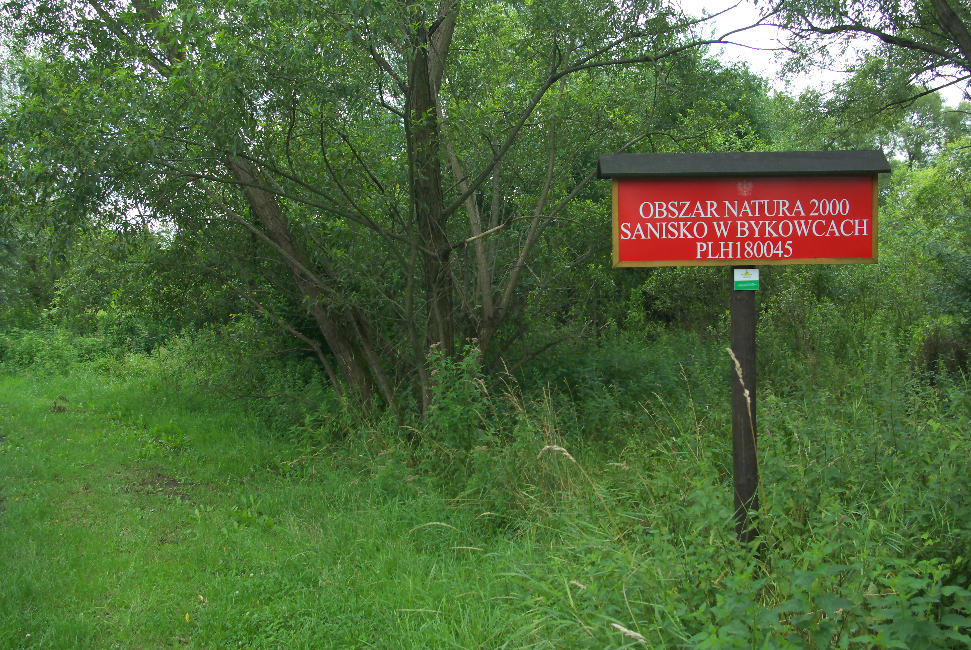
A red information sign on a wooden post surrounded by lush green foliage reads OBSZAR NATURA 2000, SANISKO W BYKOWCACH, PLH180045.
Information sign marking the Sanisko w Bykowcach Natura 2000 protected area.

Sanisko w Bykowcach history and protected-area timeline

Sanisko w Bykowcach entered the European conservation framework relatively recently, with its formal designation process beginning in 2011 as a proposed Site of Community Importance under the EU Habitats Directive. Its identification reflects the growing recognition across Poland of small but ecologically dense wetland and floodplain sites that had often been overlooked in earlier, more landscape-focused conservation planning, which tended to emphasize mountain forests or large national parks.

The site's later inclusion in regional-level documentation, such as the 2012 Natura 2000 area catalogue published by the Regional Directorate for Environmental Protection in Rzeszów, helped to formalize its profile and connect it to broader Polish and European conservation networks. The underlying rationale for protection is the combination of threatened habitat types and protected species that depend on the persistence of the Osława;San confluence wetlands, even where the surrounding land has long been used for farming and settlement.

Because the area is embedded in the larger Wschodniobeskidzki Obszar Chronionego Krajobrazu, its current conservation story is best understood as a layered system in which regional landscape protection, European habitat protection, and local land use all overlap.

Sanisko w Bykowcach landscape and geographic character

The physical landscape of Sanisko w Bykowcach is defined by the gentle topography of the Carpathian foothills and the strong influence of two rivers. The site occupies a flat to gently undulating section of the valley floor near the point where the Osława joins the San, and its elevation and relief are modest compared with the steeper slopes of the East Beskids further south. The terrain therefore has the character of a lowland floodplain rather than a mountain valley, even though it lies within the broader mountain foreland of the Podkarpackie region.

The most visually distinctive feature of the reserve is the network of old river channels and meanders associated with past river dynamics. These relict channels form elongated pools, marshy depressions, and narrow belts of sluggish water that contrast with the more active main channels of the Osława and the San. Around them, the land rises into low alluvial terraces and slightly higher sections that support the more stable forest habitats. The resulting terrain mosaic is irregular and intimate rather than dramatic, with water, wet meadow, shrubby thicket, and woodland alternating in close succession.

Beyond the river corridor itself, the surrounding mesoregion of Pogórze Bukowskie includes rolling agricultural land, hedgerows, and patches of woodland that frame the reserve. Within the protected area, the landscape retains a strong sense of openness along the riverbanks, where herbaceous vegetation becomes dominant in summer, while the higher edges of the site are cloaked in denser deciduous forest.

Sanisko w Bykowcach ecosystems, habitats, and plant life

Ecologically, Sanisko w Bykowcach is a small but unusually complete example of a lowland riverine habitat complex in the Carpathian foothills. The site's nature is shaped by the interaction between flowing water and the surrounding land. Old river arms create still-water conditions that develop distinctive aquatic and emergent vegetation; the regularly flooded riverbanks support tall herb communities and reed-like stands; slightly elevated terraces carry oak-hornbeam forests that have persisted as fragments of the natural woodland of the region; and the active floodplain supports classic riparian forest characterized by flood-tolerant trees and shrubs.

The fresh meadows present at the site reflect the role of low-intensity traditional land management in maintaining open, herb-rich vegetation. Where grazing or mowing has been less intensive, these meadows grade into shrubby transitions toward the forest edge. The result is a gradient from open water and wet meadow through tall herb and shrub layers to closed canopy forest, all within a relatively small footprint.

This habitat variation is the foundation of the site's biodiversity. Different animal groups specialize in the still channels, the seasonally flooded meadows, the tall herb thickets, and the more stable forest patches, and the close proximity of these environments allows species with otherwise different habitat requirements to coexist. The site also functions as a refugium for floodplain-dependent species in a region where many similar wetlands have been lost to drainage or channelization elsewhere in Poland.

Sanisko w Bykowcach wildlife and species highlights

Sanisko w Bykowcach supports a varied wildlife community typical of healthy lowland river corridors in the Carpathian foothills. The reserve is widely recognized for the presence of two flagship mammals of European wetland conservation: the Eurasian beaver, which actively shapes the channel and riparian vegetation through dam-building and bank excavation, and the Eurasian otter, which uses the river system as a year-round hunting area for fish and amphibians.

The site's amphibian fauna is also noteworthy. The northern crested newt, a species protected under the EU Habitats Directive, breeds in the calmer, vegetated waters provided by the old river arms and associated pools. The yellow-bellied toad, another species of conservation concern at the European level, finds suitable shallow, sun-warmed breeding habitat in the same section of the reserve, alongside other amphibians that benefit from the combination of still water and adjacent terrestrial cover.

Fish and other aquatic life are represented by species such as the weatherfish, a small bottom-dwelling fish associated with slow-moving or standing waters rich in organic sediment. The reserve's birdlife is rich but not described in exhaustive detail in publicly available sources; however, the combination of open water, wet meadow, reedbed-like margins, and forest edge provides nesting and foraging habitat for a wide range of species, including waders, waterfowl, songbirds of shrubby habitats, and woodland species along the floodplain forest edges.

Sanisko w Bykowcach conservation status and protection priorities

Sanisko w Bykowcach is part of the European Union's Natura 2000 network, the largest coordinated network of protected areas in the world. The site is classified as a proposed Special Area of Conservation, a designation under the EU Habitats Directive that targets habitats and species of European conservation importance. In the Polish national list it carries the code PLH180045, and it is also formally registered as a Site of Community Importance.

The reserve's conservation value rests on the combination of habitat diversity and species significance compressed into a small area. Five Annex I habitat types are present, including old river channels, riverside tall herb vegetation, fresh meadows, oak-hornbeam forests, and floodplain riparian forests, each of which is targeted for protection at the European level. Several Annex II species have also been recorded, including the Eurasian otter, the northern crested newt, the yellow-bellied toad, and the weatherfish, alongside the beaver as a highly visible indicator of wetland health.

Layered over this European designation is the regional protection provided by the Wschodniobeskidzki Obszar Chronionego Krajobrazu, a Polish protected landscape area that covers approximately 80 percent of the reserve's territory. This double protection is significant because it integrates habitat-level safeguarding with broader landscape connectivity, allowing the reserve to function as a node within a wider network of valued habitats in the East Beskid foothills. Conservation attention at the site is largely focused on maintaining the natural dynamics of the river system, preserving water quality, and preventing the further loss of meadows and forests to drainage, abandonment, or conversion.

Sanisko w Bykowcach cultural meaning and human context

The landscape around Sanisko w Bykowcach has long been shaped by traditional rural land use in the Carpathian foothills. The villages of Bykowce and the surrounding municipalities in the Sanok area have a deeply rooted agrarian culture, with small-scale farming, hay meadow management, and household-scale use of woodland having historically maintained much of the open and semi-open habitat that the reserve now protects. The persistence of fresh meadows at the site is largely a reflection of this older human relationship with the land, rather than active rewilding.

The Osława and San rivers themselves carry strong regional identity. Local communities have long depended on them for water, small-scale fishing, milling, and transport routes connecting the Beskid valleys with the broader lowlands of the San river basin. The naming of the site, "Sanisko," evokes the river San itself and points to the central role of the river system in defining the local sense of place.

In broader terms, the reserve represents a quiet example of how protected natural areas in southeastern Poland integrate with a long-established pattern of dispersed rural settlement. The cultural value of the area lies less in any single monument or landmark than in the continuity of the small valley landscape itself, where meadows, rivers, hamlets, and woodlands have long coexisted.

Top sights and standout views in Sanisko w Bykowcach

Sanisko w Bykowcach offers an unusually complete snapshot of lowland riverine ecology in a single, accessible stretch of the Polish Carpathian foothills. Its strongest points of interest include the network of old river channels around the Osława;San confluence, the dense concentration of Annex I habitats within a small footprint, and the combination of flagship species such as the beaver and the otter with protected amphibians like the northern crested newt and yellow-bellied toad.

Equally important is the layered protection status of the site: a Natura 2000 Site of Community Importance embedded within the broader East-Beskidian Protected Landscape Area. For visitors and researchers, the reserve's appeal lies in the chance to experience a compact, working example of floodplain ecology, where river dynamics, traditional meadow management, and natural forest succession all remain visible side by side.

Best time to visit Sanisko w Bykowcach

The character of Sanisko w Bykowcach shifts notably across the seasons, and each period brings a different kind of natural interest. Spring is the most biologically dynamic time of year, when fresh meadows begin to green and amphibians such as the northern crested newt and yellow-bellied toad become active in the still waters of the old river channels. Rising water levels and active beaver and otter presence also make spring a rewarding time for wildlife observation along the Osława and San.

Summer is the most visually lush period, with the riverside tall herb communities reaching full height and the floodplain forest in dense leaf. Meadows may host haymaking activity, echoing the traditional land management that helps maintain some of the site's open habitats. The warm months are also best for observing reptiles, insects, and many bird species, though denser vegetation can make viewing more challenging.

Autumn brings quieter conditions, with migratory and resident birds using the wetland and woodland mosaic as a transitional habitat before the cold sets in. Waterfowl are typically more visible in this period. Winter reveals the structural landscape most clearly: the meandering channels, the bare deciduous trees of the riparian forest, and the open meadows become the dominant visual elements, and signs of mammal activity such as beaver cuttings and otter tracks along the riverbanks are often easier to detect than in summer.


Monthly climate preview

Long term monthly temperature averages and precipitation metrics for Sanisko w Bykowcach

Sanisko w Bykowcach Climate Normals and Measured Annual Temperature Patterns

Representative point measurements reveal the long term monthly temperature progression and precipitation rhythm recorded at Sanisko w Bykowcach. Detailed twelve month climate statistics provide comprehensive insight into historical baseline patterns across the coordinates.
Annual mean7 °C
-5 °C19 °C
Jan-5°
Feb-3°
Mar
Apr
May13°
Jun17°
Jul19°
Aug19°
Sep13°
Oct
Nov
Dec-3°
Warmest month
July

18.8 °C

Coolest month
January

-4.9 °C

Wettest month
July

3.3 mm/day

Driest month
January

1.4 mm/day

Park location guide

Geography guide, regional context, and park location map for Sanisko w Bykowcach

Sanisko w Bykowcach park geography, regions, and map view in Poland

Understand where Sanisko w Bykowcach sits in Poland through a broader geographic reading of the surrounding landscape, nearby location context, and its mapped position within the national park landscape.

How Sanisko w Bykowcach fits into Poland

Poland, officially the Republic of Poland, is a Central European country spanning from the Baltic Sea in the north to the Carpathian Mountains in the south. It borders Germany, Czech Republic, Slovakia, Ukraine, Belarus, Lithuania, and Kaliningrad Oblast. The country has a temperate climate, diverse landscapes, and is known for its rich history, cultural heritage, and strong economic position within the EU.

Wider geography shaping Sanisko w Bykowcach in Poland

Poland occupies 312,696 km2 in Central Europe, extending from the Baltic Sea coast in the north to the Sudetes and Carpathian Mountains in the south. It borders Germany to the west, Czech Republic and Slovakia to the south, Ukraine and Belarus to the east, and Lithuania and Kaliningrad Oblast to the northeast. The landscape includes lowland plains, uplands, and mountain ranges.

Map view of Sanisko w Bykowcach

Use this park location map to pinpoint Sanisko w Bykowcach in Poland, understand its exact geographic position, and read its mapped placement within the surrounding landscape more clearly.

Pigeon | © OpenStreetMap contributors

Location context for Sanisko w Bykowcach

Podkarpackie Voivodeship
Recorded earthquake history

Explore the Recorded Earthquake History Associated with Sanisko w Bykowcach

MoriAtlas maintains a factual collection of seismic events recorded in the vicinity of Sanisko w Bykowcach. Review the historical data, including event magnitude and proximity, to better understand the seismic context of this Carpathian foothills protected area.

Sanisko w Bykowcach Earthquake History

Catalogued events

1 event

Strongest magnitude

Magnitude 3.6

Most recent event

Jun 29, 1992

This history includes earthquakes recorded inside the park or within 50 km of its borders

Visualizing riverine habitats, floodplain terrain, and protected wetland environments

Sanisko w Bykowcach Photos and Landscape Scenery in the Carpathian Foothills

Visual documentation captures the complex mosaic of old river channels, freshwater meadows, and riparian floodplain forests shaping Sanisko w Bykowcach. Examining these protected area views reveals the intricate lowland terrain and diverse habitats characterizing the Carpathian foothill confluence zone.

A red information sign on a wooden post surrounded by lush green foliage reads OBSZAR NATURA 2000, SANISKO W BYKOWCACH, PLH180045.

Park atlas

Compare regional riverine reserves and connected Carpathian foothill landscapes

Explore Parks Near Sanisko w Bykowcach and Surrounding Protected Areas

Browse other protected areas and river valley reserves located near Sanisko w Bykowcach in the Podkarpackie region. Expanding the search helps connect lowland floodplain habitats with the wider network of regional conservation landscapes.
Protected areaPodkarpackie Voivodeship
0.2 km away#1 closest

East

Ostoja Góry Słonne: Geographic Analysis of Protected Carpathian Forest and Foothills

Mapping natural boundaries in the Podkarpackie Voivodeship

Ostoja Góry Słonne represents a significant protected area within the Polish Carpathians, characterized by its dense beech forest cover and high biodiversity. This site serves as a vital refuge for large mammals and diverse riparian species, with its landscape of forested ridges and river valleys providing essential habitat connectivity across the Słonne Mountains and Przemyskie Foothills.

Area
460.715 km²
Established
2009
Relief
Mountain
Climate
Temperate
Nature reservePodkarpackie Voivodeship
5.4 km away#2 closest

Northeast

Rzeka San Nature Reserve: Mapped Geographic Overview and Protected Riverine Corridor

Protected landscape geography in Podkarpackie Voivodeship

Rzeka San is a significant river-based nature reserve that defines a crucial ecological passage through southeastern Poland. By focusing on the aquatic and riparian habitats along the San River, this protected area provides vital support for diverse freshwater species. Its strategic position within the Podkarpackie Voivodeship and its integration with larger landscape parks showcase a complex, multi-layered approach to regional environmental conservation and riverine terrain management.

Area
13.75 km²
Established
2009
Scope
Terrestrial
Water
Water-dominated
Nature reservePodkarpackie Voivodeship
About 10 km away#3 closest

East

Dyrbek Nature Reserve: Protected Carpathian Beech Forests and Słonne Mountains Geography

A mountain forest refuge in the Podkarpackie Voivodeship

Dyrbek Nature Reserve functions as a critical forest conservation area, sheltering mature beech communities within the rugged topography of the Słonne Mountains. This site offers insight into the mesic forest ecosystems of the Eastern Carpathians, serving as a haven for sensitive raptors and forest birds that rely on undisturbed canopy cover in the southeastern Polish highlands.

Area
1.301 km²
Established
1996
Relief
Mountain
Climate
Temperate
Protected areaPodkarpackie Voivodeship
16 km away#4 closest

West

Patria nad Odrzechową: A Detailed Geographic Study of Protected Polish Carpathian Forest Lands

Deciduous forest mosaic in the Bukowskie Foothills

Patria nad Odrzechową is a key protected area in Poland, renowned for its concentration of European-priority beech and oak-hornbeam forests. The site provides a compact, representative look at the transitional forest ecology of the Subcarpathian region, preserved within the larger Beskid Niski landscape framework. Explore the specific habitat boundaries and terrain features that define this essential woodland corridor.

Area
5.73 km²
Established
2011
Relief
Upland
Scope
Terrestrial
Protected landscapePodkarpackie Voivodeship
20 km away#5 closest

South

Ciśniańsko-Wetliński Park Krajobrazowy: Geography and Protected Area Landscape Context

A vital Carpathian conservation corridor in Podkarpackie Voivodeship.

Spanning heavily forested peaks and deeply incised river gorges, Ciśniańsko-Wetliński Park Krajobrazowy functions as a core refuge for large carnivores and rare yew populations. Its distinct flysch geology and altitudinal vegetation sequences establish it as an essential component of the international Eastern Carpathians ecological network.

Area
514.61 km²
Established
1992
Relief
Mountain
Climate
Temperate
Protected areaPodkarpackie Voivodeship
20 km away#6 closest

West

Rymanów Protected Area: Map and Landscape Overview in Podkarpackie Voivodeship

Forested foothill geography and Natura 2000 site boundaries

Located in the Podkarpackie Voivodeship, Rymanów is a 52-square-kilometer protected area defined by its rolling Bukowskie Foothills terrain. This site highlights the intersection of traditional architecture and subcarpathian forest, providing critical habitat within the larger Beskid Niski Protected Landscape Area. Examine the spatial relationship between its protected roosts and surrounding foraging zones.

Area
52.41 km²
Established
2009
Relief
Upland
Scope
Terrestrial
Protected areaPodkarpackie Voivodeship
22 km away#7 closest

Southwest

Ostoja Jaśliska Protected Area: Carpathian Forest Landscapes and Ecological Geography

Exploring Natura 2000 boundaries in Podkarpackie Voivodeship

The Ostoja Jaśliska protected area sits within the Beskid Niski range, offering a deep look into Carpathian beech forest communities and rare peatland habitats. The region holds nine distinct nature reserves and provides essential connectivity for apex predator populations. This geographic profile details the terrain and environmental importance of this expansive protected polygon in southeastern Poland.

Area
292.521 km²
Established
2009
Relief
Mountain
Climate
Temperate
Nature reservePodkarpackie Voivodeship
22 km away#8 closest

Northwest

Wisłok Środkowy z Dopływami Protected Nature Reserve in the Podkarpackie Voivodeship

River corridor geography and riparian ecosystem analysis

Wisłok Środkowy z Dopływami serves as a crucial Natura 2000 site, safeguarding the middle course of the Wisłok River and the Stobnica tributary. This nature reserve provides essential habitat for various protected fish species and butterfly populations within a terrain shaped by the transition between the Jasielsko-Krośnieńska Basin and the Carpathian foothills. The area represents a significant riparian landscape, offering a window into the natural freshwater geography of southeastern Poland.

Area
10.646 km²
Established
2011
Relief
Upland
Scope
Terrestrial

Common questions about visiting, size, designation, and location context for Sanisko w Bykowcach

Sanisko w Bykowcach FAQs for park facts, access, geography, and protected area context

Find quick answers about Sanisko w Bykowcach, including protected-area facts, park geography, trail and visitor context, and how the park fits into its surrounding country and regional landscape.
MoriAtlas Explorer

Continue Your Protected Areas Search Across the Global Atlas

Deepen your exploration by continuing the structured search for national parks and protected areas worldwide. Utilize the comprehensive filtering capabilities to compare different conservation landscapes and refine your understanding of global park geography. Discover more about the distribution and characteristics of protected natural areas.

Global natural geography