
Mori Atlas logo
Nature reserveSchachenwald

Tracing the geological boundaries and terrain of this protected Rheinland-Pfalz habitat

Schachenwald Nature Reserve: A Detailed Atlas of Sand Dune and Wetland Mosaic Landscapes

(Naturschutzgebiet Schachenwald)

Schachenwald preserves a distinct ecological mosaic defined by the intersection of sandy dune forests and moisture-rich alder swamp woodlands. Located across the Kaiserslautern district in Rheinland-Pfalz, the reserve sits upon a Buntsandstein ridge where wind-blown sand deposits create subtle dunes rising above peat-forming depressions. This site offers significant insight into small-scale habitat management and the geological signatures of regional sandstone formations.

sand dune forestinland dunesalder swamp woodlandBuntsandstein ridgehabitat management areaIUCN Category IV
A flat vector illustration of a valley featuring a winding dirt path in the foreground, surrounded by coniferous trees, leading toward a distant waterfall framed by rocky cliffs under a soft sky.

Schachenwald

Nature reserve

Park overview

Structured park overview, official facts, and landscape profile for Schachenwald

Schachenwald park facts, protected area profile, and essential visitor context

Review the core facts for Schachenwald, including designation, size, terrain, visitor scale, habitats, and operating context in one park-focused overview.

About Schachenwald

Schachenwald is a compact protected landscape in western Rhineland-Palatinate, situated in the Landkreis Kaiserslautern on the edge of the settlements of Hütschenhausen, Ramstein, and Spesbach. The reserve is small in scale, covering roughly 64 hectares, but it is ecologically specific: rather than a uniform forest block, it combines sandy dune woodland with a wetter zone of alder swamp woodland (Erlenbruchwald) to the south. Together these habitats create the transition zones, or ecotones, that the designation specifically aims to protect.

The site's ecology is closely tied to the underlying geology. The area rests on a ridge of Buntsandstein, the red Lower Triassic sandstone that dominates much of the Palatinate landscape. Across this ridge, wind-deposited sand built up small dunes that now form the substrate for a distinctive inland dune forest community. Toward the lower, moister ground on the southern side of the site, conditions shift to a peat-influenced environment supporting alder-dominated wet woodland, creating a sharp contrast in vegetation and hydrology within a relatively small footprint.

Because the reserve combines a defined substrate feature (dunes on sandstone), clearly delimited habitat types, and the ecotones between them, it functions as a targeted conservation site rather than a general-purpose landscape reserve. Its IUCN Category IV designation as a Habitat/Species Management Area reflects this purpose: the reserve exists to maintain active conditions for the habitats and species that depend on them, including the rare wild plant species and characteristic animal communities that occur in such sandy and boggy forest mosaic settings.

Schachenwald is part of a broader network of nature reserves in the Landkreis Kaiserslautern, which also includes sites such as the Landstuhler Bruch to the west and other dune, bog, and meadow reserves across the district. Within that network, Schachenwald contributes a specific inland dune forest reference point, complementing wetter sites like the surrounding moor and brook reserves with a drier, sand-influenced habitat type.

Quick facts and research context for Schachenwald

Schachenwald is a nature reserve of about 63.8 hectares in the Landkreis Kaiserslautern, Rhineland-Palatinate, Germany. It lies within the municipal areas of Hütschenhausen, Ramstein-Miesenbach, and Spesbach, and has been formally protected since 1987. The site is catalogued under the identifier 335096 and the World Database on Protected Areas entry 165347, and is classified as an IUCN Category IV Habitat/Species Management Area. Its conservation focus is on inland sand dune forests with ecotones, alder swamp woodland, and the geological features of wind-deposited dunes on the local Buntsandstein ridge.

Protection and recognition

Documented terrestrial protection scope and baseline administrative management data

Schachenwald Protection Status and Official Conservation Designation Records

Schachenwald maintains a documented terrestrial protection scope within the global protected area registry. Official conservation records outline the baseline administrative framework, designation context, and international database metadata.

Protection details

Protection scope
Terrestrial
Transboundary protection
No
WDPA ID
165347
Park context

Deeper park guide and search-rich context for Schachenwald

Schachenwald history, landscape, wildlife, and travel context

Explore Schachenwald through its history, landscape character, ecosystems, wildlife, conservation priorities, cultural context, and seasonal travel timing in a structured park guide built for atlas discovery and search intent.

Why Schachenwald stands out

Schachenwald is best known for its inland sand dune forest communities and the adjacent alder swamp woodland (Erlenbruchwald) that they shelter. It is also notable for the small dunes that rise roughly one meter above the surrounding peatland, formed by historical sand drift over the underlying Buntsandstein ridge, giving the reserve a compact but layered ecological and geological character.
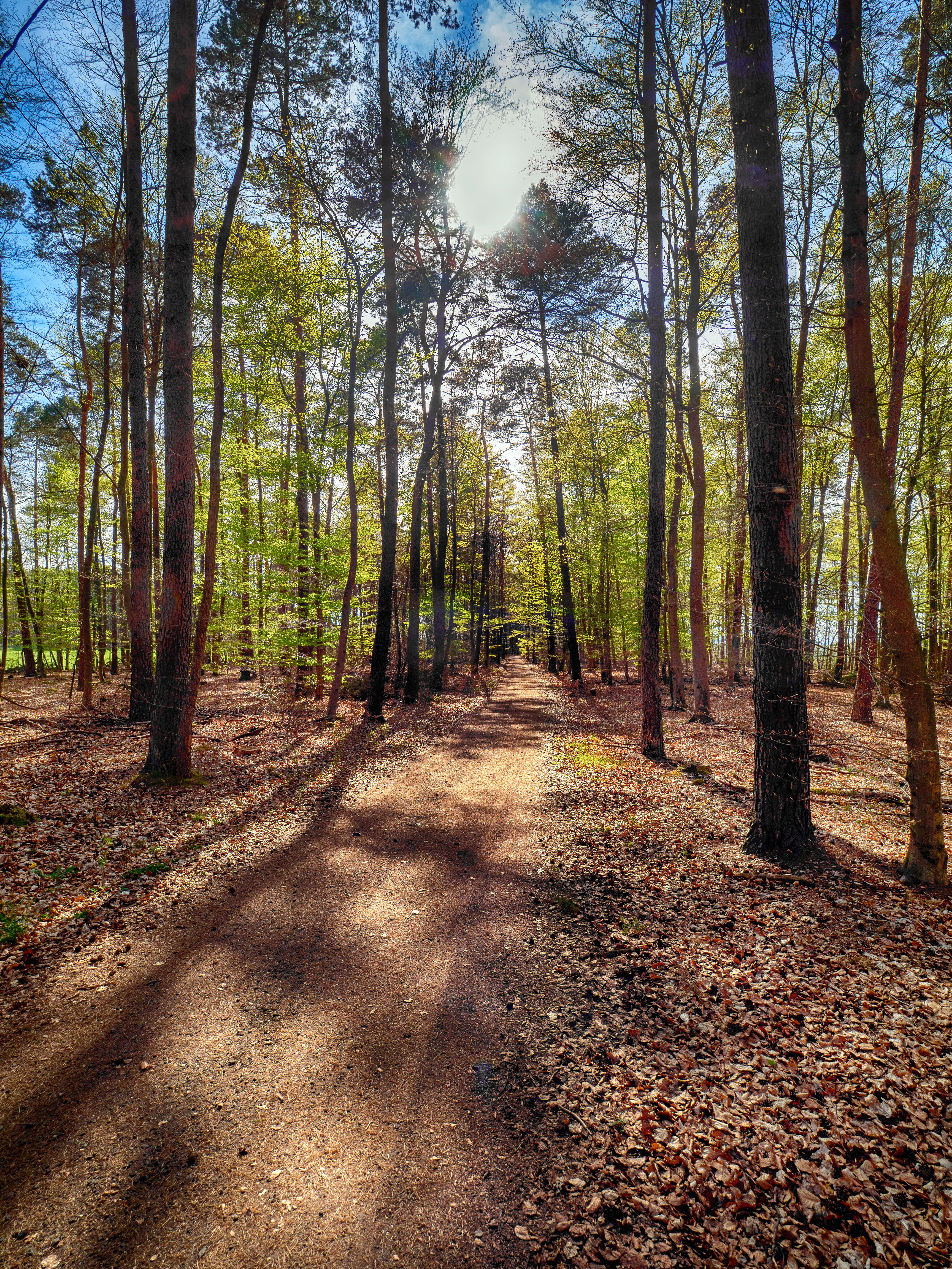
A dirt path leads into a dense forest with tall trees casting long shadows, with sunlight filtering through the canopy above.
A tranquil trail winds through the forested landscape of Schachenwald nature reserve.

Schachenwald history and protected-area timeline

Schachenwald was formally designated as a nature reserve (Naturschutzgebiet) in 1987, under the protection framework of Rhineland-Palatinate. The designation brought together pre-existing natural features of the area, sandy dune woodland and alder swamp woodland, under a single protective framework, recognizing their combined value for rare and characteristic species.

The underlying landscape predates the designation by a considerable margin. The dunes within the reserve formed over long periods through wind-driven sand deposition across the local Buntsandstein ridge, creating the subtle relief that still defines the site today. By formally protecting the area, the 1987 designation sought to preserve both the habitats and the natural-history features that record the region's geological and ecological development.

Schachenwald landscape and geographic character

The terrain of Schachenwald reflects its underlying sandstone geology. The site sits on a Buntsandstein ridge, the kind of weathered Lower Triassic sandstone platform that underpins much of the Palatinate landscape. Across this ridge, sand has been transported and deposited by wind over time, producing low dunes that protrude only about one meter above the surrounding wet ground.

These dunes are subtle rather than dramatic, but they create the dry substrate that supports the inland sand dune forest community. Toward the southern part of the reserve, the ground becomes moister and transitions into a peat- and bog-influenced environment, occupied by alder swamp woodland. This small-scale juxtaposition of dry dune ridges and damp, boggy low ground gives the reserve its unusual landscape signature within the district.

Schachenwald ecosystems, habitats, and plant life

The habitats of Schachenwald are the core of its conservation value. The dominant community is an inland sand dune forest, an unusual forest type in central Europe and one that supports plant species and ecological conditions distinct from typical woodland. Within this forest, numerous transition zones, or ecotones, occur where dry sand gradually gives way to wetter conditions, each carrying its own characteristic mix of species.

South of the dune forest lies a zone of Erlenbruchwald, alder swamp woodland that grows on the wetter, peat-influenced ground. This community is typical of bog and moor margins, and the contrast between it and the drier dune forest above sharpens the habitat diversity of the reserve. Together the dune forest, the alder swamp, and the ecotones between them sustain both rare wild plant species and the animal communities that depend on these specific habitats and on the complex mosaic they form.

Schachenwald wildlife and species highlights

Wildlife interest at Schachenwald is closely tied to the habitat mosaic rather than to single charismatic species. The dune forest and the alder swamp woodland together create the conditions for characteristic and rare species assemblages typical of sandy substrates and boggy woodland margins. Animal communities are maintained through the presence of both the dry dune forest and the adjacent wet woodland, with the ecotones between them providing additional structural diversity for species that rely on transitional conditions.

Schachenwald conservation status and protection priorities

Schachenwald is classified under IUCN Category IV as a Habitat/Species Management Area, a designation that highlights its role in active management of particular habitats and the species they support. The reserve's purpose is explicitly to safeguard the sand dune forests with their ecotones, the southern alder swamp woodland, and the species communities they sustain, including rare wild plant species and characteristic animal communities.

A secondary conservation rationale lies in the site's natural-history and regional-landscape value. The dunes themselves, formed by wind-deposited sand over the Buntsandstein ridge, are preserved as features of the regional geological record, alongside the biological habitats that have developed on them. Within the wider network of nature reserves in the Landkreis Kaiserslautern, Schachenwald contributes a specific inland dune forest reference point, complementing the district's wetland and bog reserves.

Top sights and standout views in Schachenwald

The standout qualities of Schachenwald lie in its combination of features within a small area: inland sand dune forest on a weathered Buntsandstein ridge, low dunes rising roughly a meter above surrounding boggy ground, and a southern fringe of alder swamp woodland with sharp ecotones between dry and wet habitats. Together these give the reserve a tightly defined ecological identity that distinguishes it from the broader wetland reserves of the Landkreis Kaiserslautern.

Best time to visit Schachenwald

Schachenwald is a quiet natural-area reserve rather than a tourist attraction, and seasonal conditions mainly affect what can be observed. Late spring and early summer tend to bring out the contrast between the dry dune woodland and the moist alder swamp, when ground vegetation is most active. In autumn, the dune forest's mixed deciduous character can offer more visible seasonal color, while wetter periods will emphasize the bog-influenced southern part of the reserve. Winter visits are possible but the subtle dune relief is less evident under heavy leaf cover or frost.

Monthly climate preview

Long-term representative point measurements for monthly weather analysis in Rheinland-Pfalz

Schachenwald Climate Normals, Annual Temperature and Precipitation Rhythm

Representative coordinate records show measured monthly temperature variation alongside consistent precipitation levels across the conservation area. Detailed monthly climate profiles provide complete statistical breakdowns of long-term temperature ranges and precipitation patterns.
Annual mean9 °C
0 °C19 °C
Jan
Feb
Mar
Apr
May13°
Jun17°
Jul19°
Aug19°
Sep14°
Oct
Nov
Dec
Warmest month
July

19.2 °C

Coolest month
January

-0.2 °C

Wettest month
December

2.4 mm/day

Driest month
April

1.5 mm/day

Park location guide

Geography guide, regional context, and park location map for Schachenwald

Schachenwald park geography, regions, and map view in Germany

Understand where Schachenwald sits in Germany through a broader geographic reading of the surrounding landscape, nearby location context, and its mapped position within the national park landscape.

How Schachenwald fits into Germany

Germany is a federal republic in Western and Central Europe with a population of over 83 million across sixteen constituent states. It is Europe's largest economy by nominal GDP and a major global exporter and importer. The capital is Berlin, and the country borders Denmark, Poland, Czech Republic, Austria, Switzerland, France, Luxembourg, Belgium, and the Netherlands.

Wider geography shaping Schachenwald in Germany

Germany is located in Western and Central Europe, spanning 357,022 km². It borders Denmark to the north, Poland and the Czech Republic to the east, Austria and Switzerland to the south, and France, Luxembourg, Belgium, and the Netherlands to the west. The country has coastlines on the Baltic Sea and North Sea to the north, with the Alps located in the southern region.

Map view of Schachenwald

Use this park location map to pinpoint Schachenwald in Germany, understand its exact geographic position, and read its mapped placement within the surrounding landscape more clearly.

Pigeon | © OpenStreetMap contributors

Location context for Schachenwald

Rheinland-Pfalz

Examine protected area views, sand dune forests, and wetland terrain.

Schachenwald Photos and Landscape Imagery for Visual Park Exploration

Visual records document the distinct sand dune forests and alder swamp woodland habitats protected across Schachenwald. Photographic evidence reveals the subtle geological relief and contrasting wet and dry terrain of the nature reserve.

A dirt path leads into a dense forest with tall trees casting long shadows, with sunlight filtering through the canopy above.

Park atlas

Discover related nature reserves and regional protected areas in the Palatinate district

Explore Parks Near Schachenwald and Surrounding Protected Landscapes

Compare Schachenwald with other protected areas across the surrounding region to analyze regional park geography and distinct habitat networks. Browsing adjacent reserves provides valuable context into local sand dune forests and wetland ecosystems.
Nature reserveRhineland-Palatinate
Mapped location lies within the park boundary#1 closest

Northeast

Westricher Moorniederung Nature Reserve: Protected Wetland and Moorland Atlas

Mapping low-lying basin landscapes and riparian corridors in the German Palatinate.

Spanning 40 kilometers between the Bliesaue and Kaiserslautern, the Westricher Moorniederung protects an intricate network of bogs, marsh zones, and alluvial forests. This lowland basin acts as a vital ecological link within Rhineland-Palatinate, defined by its drainage systems and diverse mire habitats. Gain insight into the regional geography and protected land boundaries that define this significant wetland system.

Area
21.52 km²
Established
1998
IUCN
IV
A minimalist watercolor illustration featuring a green treeline, soft rolling hills, and a calm body of water in warm light tones on a white background.
Protected landscapeRhineland-Palatinate
About 2.4 km away#2 closest

West

Landstuhler Bruch Protected Landscape: Regional Geography and Mapped Wetland Basin

Exploring the historic moorland basin of the Westpfalz

Situated in the Westpfalz region of Rhineland-Palatinate, the Landstuhler Bruch is a gentle lowland depression marked by a complex history of drainage and conservation. This protected area offers deep insight into the regional geology, preserved wetland pockets, and hydrological networks that define the local landscape. Understanding this basin provides a window into the intersection of cultural heritage and active ecological restoration in southwestern Germany.

Area
67 km²
Established
1985
IUCN
V
Relief
Lowland
A soft, light-toned watercolor painting of a wetland landscape featuring a small stream, grassy banks, and a treeline under a pale pink sky.
Nature reserveRhineland-Palatinate
About 3.3 km away#3 closest

West

Scheidelberger Woog Nature Reserve: Geographic Overview of a Palatinate Wetland Landscape

Tracing the protected peat-rich moorland boundaries in Rhineland-Palatinate

Scheidelberger Woog stands as a vital nature reserve and lowland moor basin in the western Palatinate. Its mapped terrain features a fine-grained mosaic of reed beds, damp woodlands, and river-fed ponds. This geographic detail provides essential insight into the area's ongoing conservation efforts and its role within the wider moor network of the Kaiserslautern district.

Area
2.32 km²
Established
1987
Relief
Lowland
Scope
Terrestrial
A watercolor painting showing a green valley with a meandering river, low hills in the distance, and light pink clouds in the sky.
Nature reserveRhineland-Palatinate
About 5.1 km away#4 closest

West

Glanniederung bei Elschbach: Protected River Floodplains and Wetland Geography

Nature reserve habitat and riparian landscape mapping

Spanning the Glan river valley in Rhineland-Palatinate, this nature reserve conserves a vital mosaic of wet meadows, reed beds, and near-natural stream courses. Gain insight into the regional conservation geography of this Palatinate habitat management area, where floodplain landforms define the ecological character of the protected valley floor.

Area
0.533 km²
Established
1987
IUCN
IV
Relief
Lowland
Nature reserveRheinland-Pfalz
About 7.8 km away#5 closest

West

Neuwoogmoor Nature Reserve: Protected Peatland and Wetland Landscape Mapping in Rheinland-Pfalz

Essential geographic data on this historic Palatinate mire system.

Neuwoogmoor serves as a crucial nature reserve in Rheinland-Pfalz, protecting one of the few remaining peat moorland fragments in the Landstuhler Bruch. The site encompasses a diverse mosaic of bog pools, reed beds, and bog woodland that create an intimate and highly structured wetland terrain. This detailed entry provides geographic context on its protected status, hydrological features, and role as a habitat for rare plant communities in the western Palatinate landscape.

Area
0.6 km²
Established
1986
IUCN
IV
Relief
Lowland
Nature reserveRheinland-Pfalz
About 12 km away#6 closest

East

Täler und Verlandungszone am Gelterswoog: Nature Reserve and Wetland Geography

A mosaic of lakes, mires, and stream valleys in Rheinland-Pfalz

Located in the Palatinate Forest, this protected nature reserve centers on the western shores of the Gelterswoog lake. It conserves a rare assembly of habitats including peat-forming moorland, reeds, and narrow forested valleys that provide essential breeding grounds for protected dragonfly species.

Area
0.554 km²
Established
1997
A soft watercolor illustration depicting rolling green hills and meadows with subtle hints of pink flora, set against a pale background.
Nature reserveRhineland-Palatinate
About 14 km away#7 closest

South

Battweiler Höhe Nature Reserve: Mapped Protected Landscapes and Ridge Geography in Germany

A vital calcareous grassland habitat in the Zweibrücken hill country

Battweiler Höhe preserves a rare strip of semi-dry, lime-rich grassland on a gentle hill ridge in the Südwestpfalz district. This nature reserve in Rhineland-Palatinate exemplifies specialized habitat conservation, protecting a mosaic of meadows and forest edges that support uncommon plant species like pasqueflowers and orchids. The site is a significant link in the broader regional biotope network, maintaining its ecological health through traditional land management.

Area
0.244 km²
Established
2003
Nature reserveRheinland-Pfalz
About 15 km away#8 closest

East

Naturschutzgebiet Vogelwoog-Schmalzwoog: An Urban-Edge Wetland and Forest Mosaic in Germany

Protected nature reserve in the Rheinland-Pfalz region.

Naturschutzgebiet Vogelwoog-Schmalzwoog represents a significant micro-landscape characterized by the Vogelwoog lake and surrounding peat bogs. This protected area contains a dense concentration of ecosystems ranging from wet meadows to sand grasslands, showcasing the importance of small-scale conservation within the Hammerbach valley. Access map-driven details on the varied terrain that defines this unique Rhineland-Palatinate nature reserve.

Area
0.22 km²
Established
1996
Relief
Lowland
Climate
Temperate

Common questions about visiting, size, designation, and location context for Schachenwald

Schachenwald FAQs for park facts, access, geography, and protected area context

Find quick answers about Schachenwald, including protected-area facts, park geography, trail and visitor context, and how the park fits into its surrounding country and regional landscape.
MoriAtlas Explorer

Continue Your Protected Areas Search Across the Global Atlas

Deepen your exploration by continuing the structured search for national parks and protected areas worldwide. Utilize the comprehensive filtering capabilities to compare different conservation landscapes and refine your understanding of global park geography. Discover more about the distribution and characteristics of protected natural areas.

Global natural geography