
Why Scheftheimer Wiesen stands out
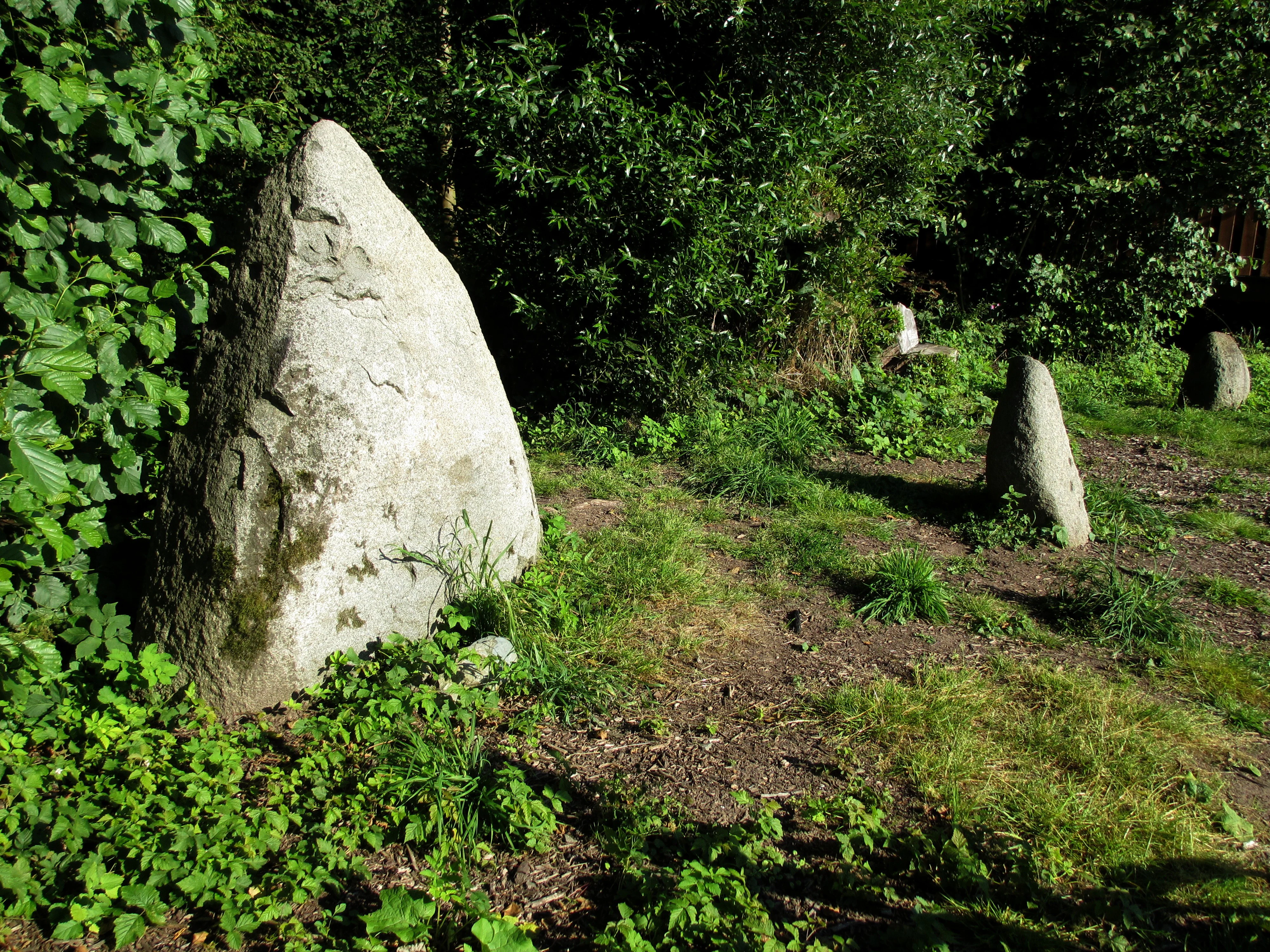
The Scheftheimer Wiesen are best known for their extensive wet meadow habitats (Feuchtbiotope) that emerged after centuries of changing land use, transitioning from imperial hunting grounds of the Landgraves of Hesse-Darmstadt to briefly cultivated farmland, and finally to ecologically valuable, protected wetlands. The reserve is also notable for the unusual combination of natural and cultural heritage within a single protected area. The reconstructed menhir arrangement and prehistoric burial mounds, situated right alongside the Ruthsenbach and its wet meadows, make the Scheftheimer Wiesen a meaningful example of how historical human activity and ecological recovery coexist in the Darmstadt region.
Scheftheimer Wiesen history and protected-area timeline
The Scheftheimer Wiesen have a long history shaped first by princely hunting, then by agriculture, and finally by nature conservation. During the 16th and 17th centuries, the open meadow areas formed part of the hunting grounds of the Landgraves of Hesse-Darmstadt. These were used for the so-called "Eingestelltes Jagen" (a form of staged hunt) in which hunters could shoot game conveniently from elevated wooden stands positioned within the landscape.
After the end of princely hunting activity, parts of the meadows were converted to arable farmland. However, unlike the western Oberfeld, where cultivation persisted, farming on the Scheftheimer Wiesen was eventually abandoned. This shift allowed wet habitats (Feuchtbiotope) to develop naturally on the former fields.
The conservation value of these recovering wet meadows eventually led authorities to formally protect the area. In 1993, the Scheftheimer Wiesen were designated as a Hessian nature reserve (Naturschutzgebiet), a status that continues to safeguard the area's ecological and cultural-historical character today. The reserve name itself is linked to a long-lost medieval settlement, Scheftheim, recorded in Darmstadt as early as 1521 and continuing to appear under varying spellings until at least the 17th century, with the place name likely referring to a sloping ("abschüssige") location.
Scheftheimer Wiesen landscape and geographic character
The landscape of the Scheftheimer Wiesen is defined by a long, southeast-trending corridor of open meadows set within the broader Oberwald forest east of Darmstadt. The reserve runs along the Ruthsenbach, whose watercourse helps create the moist conditions that give the area its ecological character. To the north, the Steinbrücker Teich pond marks the entry point of the meadow landscape, while to the southeast the terrain gradually merges with the surroundings of Rossdorf.
Topographically, the area combines flat and gently sloping meadow terrain with adjacent woodland edges. Wet zones along the Ruthsenbach contrast with drier margins, producing a mosaic of grass, reed, and shrubby habitats within a relatively narrow but elongated protected strip. The presence of prehistoric monuments such as the menhir arrangement and burial mounds further shapes the visible landscape, integrating cultural landmarks into the otherwise nature-focused terrain.
The surrounding infrastructure, including the Dieburger Straße and the B 26 federal highway, frames the reserve between Darmstadt and its eastern outskirts, while the historic Jagdschloss Kranichstein and the broader Oberwald provide a forested, park-like backdrop. This combination of waterways, meadows, forest margins, archeological features, and transport corridors gives the Scheftheimer Wiesen a clearly defined yet varied physical setting.
Scheftheimer Wiesen ecosystems, habitats, and plant life
Ecologically, the Scheftheimer Wiesen are dominated by wet meadow and moist habitat communities that developed after centuries of land-use change. The reserve's most important natural feature is its system of Feuchtbiotope, including meadows and other moisture-dependent habitats closely tied to the Ruthsenbach and adjacent groundwater conditions. The Steinbrücker Teich supports local aquatic and semi-aquatic habitat variety near the northern end of the reserve.
The wet meadows are embedded within the larger forested matrix of the Oberwald, creating ecotones between open grassland, shrubby edges, and woodland. These transitions are a key part of the reserve's ecological value, providing habitat diversity for meadow, wetland, woodland-margin, and aquatic species. The wet meadow habitats formed through agricultural abandonment make the area a notable example of spontaneous rewetting and succession within a regional landscape context.
Scheftheimer Wiesen conservation status and protection priorities
The Scheftheimer Wiesen hold clear conservation significance as a formally designated Hessian Naturschutzgebiet established in 1993. The reserve is classified as IUCN Category IV (Habitat/Species Management Area), indicating that its primary conservation role is to maintain and enhance specific habitats and species rather than to provide a strict wilderness zone.
The protected status reflects the ecological importance of the wet meadow habitats that developed naturally after the area's arable use was abandoned. By safeguarding these Feuchtbiotope, the reserve helps maintain regionally important meadow and wetland habitat complexes east of Darmstadt, complementing the Oberwald forest habitat and other Darmstadt-area protected sites. Inclusion in the World Database on Protected Areas (WDPA ID 165373) underscores the reserve's recognition within national and international protected-area frameworks.
Beyond ecological preservation, conservation management of the Scheftheimer Wiesen also implicitly protects the area's archaeological features, including the menhir arrangement and burial mounds. This integration of natural and cultural protection within a single reserve adds a distinctive dimension to its conservation profile.
Scheftheimer Wiesen cultural meaning and human context
The Scheftheimer Wiesen carry multiple layers of cultural and historical meaning. Their hunting landscape origins under the Landgraves of Hesse-Darmstadt, the eventual abandonment of agriculture, and the modern conservation designation all reflect how local communities and authorities have reinterpreted the same land over time.
Equally significant is the prehistoric dimension of the reserve. The reconstructed menhir arrangement of fourteen granite megaliths near the Ruthsenbach, and the Hügelgräber along the Bernhardsackerschneise, mark the area as a long-attested human landscape, with monuments built and used by communities far older than any medieval settlement.
The reserve's very name is itself a piece of cultural heritage. It refers to the lost medieval settlement of Scheftheim, documented under several variant spellings from 1521 through the 17th century, with the underlying place name likely describing a sloping ("abschüssige") location. Together, these layers make the Scheftheimer Wiesen a place where ecological and cultural history visibly intersect.
Top sights and standout views in Scheftheimer Wiesen
Among the Scheftheimer Wiesen's most distinctive features are its wet meadow habitats along the Ruthsenbach, which formed through the abandonment of farmland after centuries of landgravel hunting and intermittent cultivation. These habitats, together with the Steinbrücker Teich and adjoining forest margins of the Oberwald, form the ecological backbone of the reserve.
Equally striking are the area's prehistoric landmarks: the reconstructed menhir arrangement of fourteen granite blocks and the burial mounds along the Bernhardsackerschneise. Combined with the reserve's formal designation as a Hessian Naturschutzgebiet since 1993 and its IUCN Category IV status, these elements give the Scheftheimer Wiesen a rich, multi-layered identity within the Darmstadt protected-area network.
Best time to visit Scheftheimer Wiesen
Based on its character as a wet meadow and woodland-edge reserve near Darmstadt, late spring through early autumn is generally the period when the meadows are most botanically expressive and easier to explore on foot, with summer typically bringing the most active vegetation and insect life along the Ruthsenbach corridor. The reserve can be visited year-round for quiet landscape and historical landmark viewing, though wet ground conditions are common in cooler and wetter months.