

Mori Atlas logo
Nature reserveSchöbendorfer Busch

Examining the ecological boundaries and glacial terrain of this vital Brandenburg woodland.

Schöbendorfer Busch Nature Reserve: A Protected Forest Landscape in the Baruther Urstromtal

(Naturschutzgebiet Schöbendorfer Busch)

Schöbendorfer Busch represents a key protected lowland landscape situated on the floor of the Baruther Urstromtal in Brandenburg. This nature reserve preserves significant fragments of original deciduous mixed woodland, including extensive oak-hornbeam and alder swamp forest habitats. The site functions as a critical reference for dead-wood conservation and supports a rare population of old-growth dependent forest species within the sandy valley floor of northeastern Germany.

nature reservelowland forestdeciduous mixed forestoak-hornbeam forestalder swamp forestdeadwood habitat

Schöbendorfer Busch

Nature reserve

Park overview

Structured park overview, official facts, and landscape profile for Schöbendorfer Busch

Schöbendorfer Busch park facts, protected area profile, and essential visitor context

Review the core facts for Schöbendorfer Busch, including designation, size, terrain, visitor scale, habitats, and operating context in one park-focused overview.

About Schöbendorfer Busch

Schöbendorfer Busch covers roughly 831 hectares of low-lying terrain in the Baruther Urstromtal, the broad glacial meltwater valley that runs through southern Brandenburg. The reserve occupies the lowest part of the valley floor, where elevations rise only modestly from about 50 to 52 metres above sea level. To the south, the valley is bordered by the linear inland dune known as the Lange Horstberge, a striking strip of wind-blown sand that closes the view and gives the area its characteristic enclosed character.

The reserve is shaped by water and soils typical of the south Brandenburg sandlands. The Mückendorfer Graben flows through the area from the north-east toward the south-west, draining into the Hammerfließ. These small watercourses produce the persistent wet conditions that favour alder swamp woodlands in the lowest sections, while the slightly drier ground supports oak-hornbeam forest and scattered individual old oaks. Out of the total area, around 570 hectares are woodland and about 315 hectares remain in agricultural use, balancing woodland protection with the traditional farming footprint of the surrounding villages.

A significant part of Schöbendorfer Busch is set aside as a strict core zone in which forestry is excluded. The resulting high proportion of dead and decaying wood has turned the reserve into one of the most important sites in Germany for saproxylic insects and old-growth forest specialists. Heldbock longhorn beetles inhabit more than 5,000 trees, alongside the Eremit beetle and the Großer Eichenbock, while the barbastelle bat uses the old oaks and hollow trees as roost sites. The presence of finds such as the liverwort Hepatica, wood anemone, yellow anemone, muskweed, goldilocks buttercup, herb Paris, bulbil coralroot and toothwort in the understorey confirms the long continuity of broadleaf forest cover.

The protection of Schöbendorfer Busch is rooted in a 1978 ordinance and is part of the larger network of nature reserves managed within the Baruther Urstromtal landscape. The reserve also preserves a small memorial site for the longtime regional forester Norbert Schurk, who served more than thirty years in the local forestry administration and was a strong advocate for the area's conservation.

Quick facts and research context for Schöbendorfer Busch

Schöbendorfer Busch is a nature reserve (Naturschutzgebiet) in the district of Teltow-Fläming in Brandenburg, northeastern Germany, designated by ordinance on 26 June 1978. It lies south and east of Horstwalde, a district of Baruth/Mark, and extends across roughly 831 hectares, of which about 570 hectares are woodland and around 315 hectares are used for agriculture.

The terrain sits between about 50 and 52 metres above sea level, making it the lowest point of the Baruther Urstromtal. The reserve is bordered by federal highway B 96 to the east and by regional roads L 70 and L 73 to the west, north-west, and south. Two small streams, the Mückendorfer Graben and the Hammerfließ, drain the lowland soils and create the wet forest conditions that define much of the area.

Protection and recognition

Documented Natura 2000 listings and formal conservation tracking records

Schöbendorfer Busch Protection Status and International Recognition Data

Schöbendorfer Busch holds structured administrative records detailing official protected area designations and Natura 2000 network listings. Verified conservation documentation tracks international recognition status and regional management framing across public databases.
Park context

Deeper park guide and search-rich context for Schöbendorfer Busch

Schöbendorfer Busch history, landscape, wildlife, and travel context

Explore Schöbendorfer Busch through its history, landscape character, ecosystems, wildlife, conservation priorities, cultural context, and seasonal travel timing in a structured park guide built for atlas discovery and search intent.

Why Schöbendorfer Busch stands out

Schöbendorfer Busch is best known for hosting one of the largest known populations of the longhorn beetle Heldbock (Cerambyx cerdo) in Germany, and possibly in Central Europe, with more than 5,000 old oak trees occupied by the species within the reserve. The non-managed core zone maintains a high volume of standing and lying dead wood, which sustains this and other rare saproxylic beetles such as the Eremit (Osmoderma eremita) and the Great Capricorn beetle's relative, the Großer Eichenbock, as well as bats like the barbastelle (Mopsfledermaus). The reserve is also valued as one of the few surviving fragments of the original deciduous mixed forests of the Baruther Urstromtal. The combination of old oaks, alder swamp forest along the Hammerfließ and Mückendorfer Graben, and a strict no-harvest core zone gives the area an unusually continuous habitat for specialist forest species on the nutrient-poor sandy valley floor.
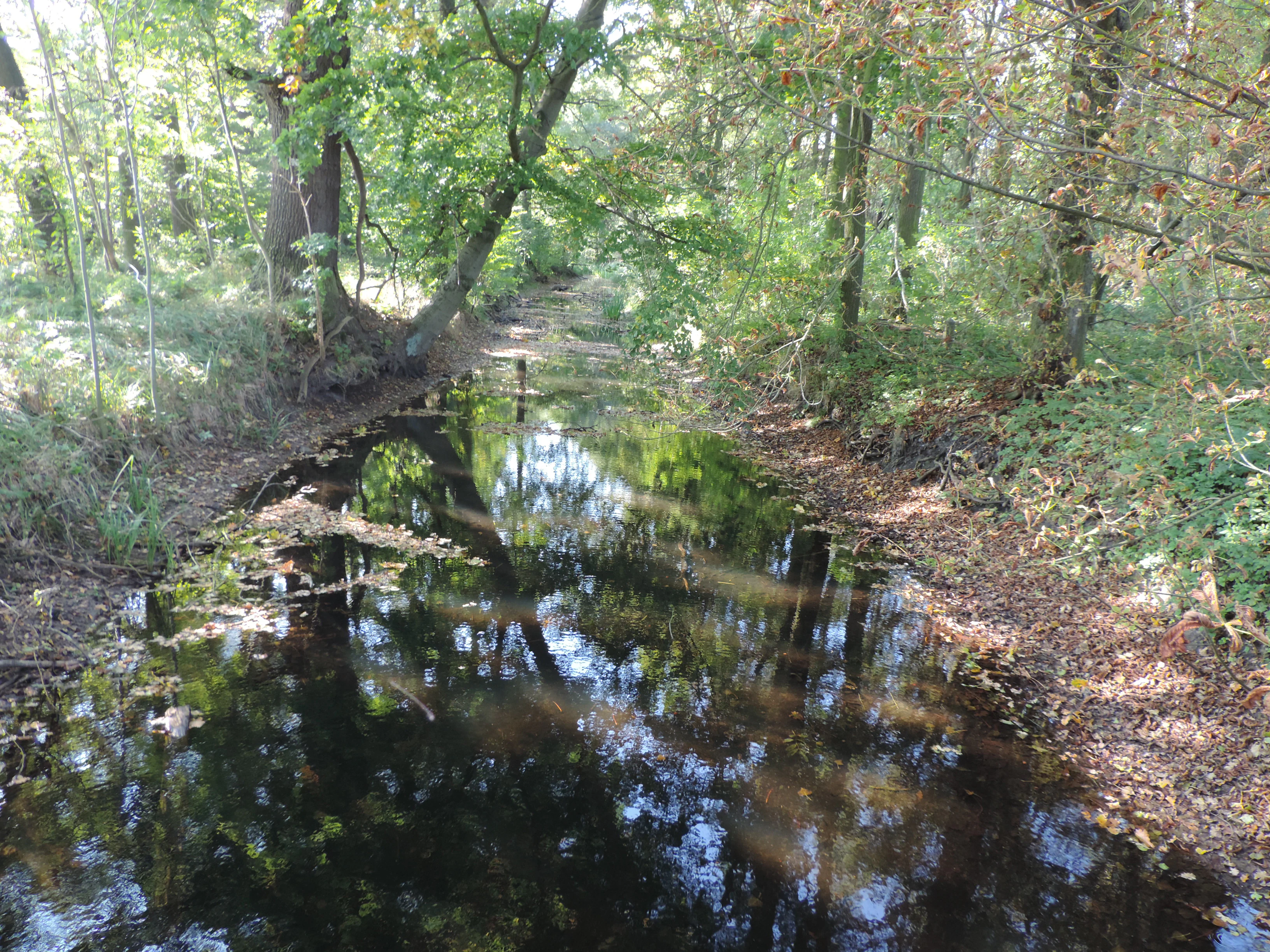
Hammerfliess in Schobendorfer Busch
The Hammerfliess stream within the Schobendorfer Busch nature reserve in Baruth/Mark

Schöbendorfer Busch history and protected-area timeline

Schöbendorfer Busch has been formally protected as a nature reserve (Naturschutzgebiet) since 26 June 1978, when the responsible Brandenburg authorities placed the area under ordinance. The designation carried the official site number 1253 and made the reserve one of the early statutory conservation sites in what was then still the GDR administrative structure, although the ordinance continued under the post-reunification Brandenburg legal framework after 1990.

The reserve was established specifically to preserve the remnants of the original deciduous mixed forests that once covered the floor of the Baruther Urstromtal. By excluding forestry from a defined core zone, the responsible forest administration sought to maintain the high proportion of old oaks, dead wood, and natural regeneration that the area still supported in the late 1970s. Over the following decades, this approach allowed the population of the Heldbock longhorn beetle and other saproxylic species to build up to nationally significant levels.

The site is also associated with the long career of Oberforstrat Norbert Schurk, who led the regional forestry offices in Sperenberg and, later, Jüterbog for more than thirty years. After his death in 2016, a memorial stone was placed in the reserve in recognition of his sustained commitment to the conservation of the Baruther Urstromtal area.

Schöbendorfer Busch landscape and geographic character

Schöbendorfer Busch occupies the lowest, flattest stretch of the Baruther Urstromtal, where the valley floor lies between roughly 50 and 52 metres above sea level. The terrain is almost uniformly level, shaped by glacial meltwater deposits and later fluvial reworking, so that small differences in elevation and water table are the main drivers of habitat variety within the reserve.

To the south of the protected area, the linear inland dune Lange Horstberge rises above the valley and forms a clear topographical boundary. The dune runs roughly east to west, sealing the lowland forest and meadows along a distinct sandy ridge. Within the reserve itself, the landscape is shaped by the Mückendorfer Graben and the Hammerfließ, two shallow streams that meander through the wet soils and create the swampy depressions where alder carr has established.

Around 570 hectares of the reserve are forested, giving it the enclosed, semicontinuous woodland character typical of larger Baruther Urstromtal sites, while approximately 315 hectares are in agricultural use as open meadows and farmland. Roads frame the area: federal highway B 96 to the east and the regional roads L 70 and L 73 to the west, north-west, and south mark the boundaries of the protected area without crossing the woodland itself.

Schöbendorfer Busch ecosystems, habitats, and plant life

The ecological identity of Schöbendorfer Busch is that of a surviving fragment of the original lowland deciduous mixed woodland of the Baruther Urstromtal. The most humid sections around the Hammerfließ and the Mückendorfer Graben carry alder swamp forest (Erlenbruchwald), while the slightly higher and drier areas are dominated by oak-hornbeam woodland (Eichen-Hainbuchenwald) with scattered old oaks. This combination of wet and dry broadleaf forest types on nutrient-poor sandy soils is increasingly rare in the region and is the backbone of the reserve's biodiversity.

The forest floor reflects this continuity of broadleaf cover. Characteristic woodland plants include the liverleaf (Hepatica nobilis), wood anemone (Anemone nemorosa), yellow anemone (Anemone ranunculoides), muskweed (Adoxa moschatellina), goldilocks buttercup (Ranunculus auricomus), herb Paris (Paris quadrifolia), bulbil coralroot (Cardamine bulbifera) and common toothwort (Lathraea squamaria). The presence of these species indicates long-standing closed-canopy deciduous woodland rather than recent plantations.

In the strict core zone, forestry is excluded, which has allowed a large amount of standing and lying dead wood to accumulate. This dead wood habitat is the key to the area's conservation value, supporting a community of fungi, lichens, bryophytes, and invertebrates that depend on decaying wood and old trees. The reserve's non-harvested core zone functions as a refuge for natural forest dynamics in a landscape that is otherwise heavily affected by forestry and agriculture.

Schöbendorfer Busch wildlife and species highlights

Schöbendorfer Busch is nationally and internationally significant for its invertebrate fauna, especially the saproxylic beetles associated with very old oak trees. The reserve hosts the country's, and likely Central Europe's, largest known population of the Heldbock longhorn beetle (Cerambyx cerdo), which inhabits more than 5,000 individual trees within the area. Other rare beetles tied to old broadleaf trees also occur, including the hermit beetle Eremit (Osmoderma eremita) and the Großer Eichenbock, both of which depend on cavities, dead wood, and the microhabitats of ancient oaks.

The vigorous dead-wood habitat also supports bats. The barbastelle (Mopsfledermaus, Barbastella barbastellus), a strictly forest-dwelling species that roosts under loose bark and in tree cavities, has been recorded in the reserve. Together with the beetle fauna, the barbastelle and other woodland bats make the area an important site for old-forest specialists whose habitats have largely disappeared from the more intensively used parts of Brandenburg's sandlands.

Schöbendorfer Busch conservation status and protection priorities

Schöbendorfer Busch has been formally protected as a nature reserve (Naturschutzgebiet) since 26 June 1978 under ordinance number 1253. Its conservation value lies in the combination of a sizeable, contiguous broadleaf forest area, a strictly protected core zone without active forestry, and a substantial stock of old oaks and dead wood. This combination makes it one of the few sites in Brandenburg where natural forest dynamics and dead-wood habitats can develop over long timescales.

The reserve plays an outsized role for saproxylic beetle conservation in Germany and Central Europe. The fact that Cerambyx cerdo, Osmoderma eremita, and the Großer Eichenbock all sustain breeding populations within a single site, and that Cerambyx cerdo alone occupies more than 5,000 trees, marks Schöbendorfer Busch as a reference site for the management of old oak woodland at national level. The presence of the barbastelle bat adds a further layer of importance, as the species depends on the same old-tree and dead-wood structures.

At landscape scale, the reserve contributes directly to the conservation network of the Baruther Urstromtal, where several smaller and larger protected areas together aim to preserve the valley's mixed forest, meadow, stream, and dune habitats. By maintaining the deepest, wettest portion of the valley in a near-natural state, Schöbendorfer Busch helps anchor ecological connectivity in a region where sandy, easily drained soils have otherwise driven much of the land into intensive agriculture and pine forestry.

Schöbendorfer Busch cultural meaning and human context

Schöbendorfer Busch is closely tied to the cultural landscape of the Baruther Urstromtal, a region whose villages, fields, and forest patches have long shaped the rural identity of southern Brandenburg. The reserve itself is bordered by the small village of Horstwalde, part of the town of Baruth/Mark, and by traditional farmland that has been part of the working landscape for generations. Roughly one-third of the area is still in agricultural use, reflecting this long-standing mixed land use rather than a fully rewilded setting.

The reserve also carries a personal memory of regional forest management. A memorial stone in the area commemorates Norbert Schurk, an Oberforstrat who led the local forestry offices in Sperenberg and, later, Jüterbog for more than thirty years and was a key advocate for the conservation of the Baruther Urstromtal. The memorial underlines how the natural values of Schöbendorfer Busch have been shaped by sustained human stewardship rather than by abandonment, and how regional foresters have been central to maintaining the area's protected status.

Top sights and standout views in Schöbendorfer Busch

Schöbendorfer Busch is one of the most important sites in Germany for old-oak and dead-wood dependent species, particularly the Heldbock longhorn beetle, which inhabits more than 5,000 trees within the reserve.

The protection of large tracts of oak-hornbeam and alder swamp forest on the floor of the Baruther Urstromtal, the strict no-harvest core zone with abundant dead wood, the presence of rare spring woodland herbs such as liverleaf and bulbil coralroot, and the record of the barbastelle bat together make Schöbendorfer Busch a textbook example of lowland deciduous forest conservation on the Brandenburg sandlands.

Best time to visit Schöbendorfer Busch

As a quiet woodland reserve on the floor of the Baruther Urstromtal, Schöbendorfer Busch can be visited across much of the year. Late spring, when the understorey of oak-hornbeam forest comes into bloom with wood anemone, yellow anemone, liverleaf, herb Paris, and other characteristic species, is particularly attractive for visitors interested in woodland flora. Early summer offers the densest display of leaves and the most complete forest experience, while late summer and early autumn bring noticeable insect and bird activity in the older oak stands.

Because the reserve lies at the lowest point of the Baruther Urstromtal, it can stay wet and muddy underfoot after heavy rain or during the snowmelt period, so drier spells in late spring and summer are usually the most comfortable for walking. The surrounding agricultural land and the bordering Lange Horstberge dune also give the landscape a softer, more open appearance in early spring and late autumn, when the contrast between forest, fields, and dune ridge is most visible.

Monthly climate preview

Long-term representative monthly temperature and precipitation patterns in Brandenburg

Schöbendorfer Busch Climate Normals and Annual Temperature Rhythm

Representative coordinate records show measured monthly temperature variations and precipitation averages across the protected terrain. Analyzing the complete twelve-month sequence reveals long-term climatological trends for Schöbendorfer Busch.
Annual mean10 °C
-1 °C20 °C
Jan-1°
Feb
Mar
Apr
May14°
Jun18°
Jul20°
Aug20°
Sep15°
Oct
Nov
Dec
Warmest month
July

20.3 °C

Coolest month
January

-0.7 °C

Wettest month
July

2.4 mm/day

Driest month
April

1.1 mm/day

Park location guide

Geography guide, regional context, and park location map for Schöbendorfer Busch

Schöbendorfer Busch park geography, regions, and map view in Germany

Understand where Schöbendorfer Busch sits in Germany through a broader geographic reading of the surrounding landscape, nearby location context, and its mapped position within the national park landscape.

How Schöbendorfer Busch fits into Germany

Germany is a federal republic in Western and Central Europe with a population of over 83 million across sixteen constituent states. It is Europe's largest economy by nominal GDP and a major global exporter and importer. The capital is Berlin, and the country borders Denmark, Poland, Czech Republic, Austria, Switzerland, France, Luxembourg, Belgium, and the Netherlands.

Wider geography shaping Schöbendorfer Busch in Germany

Germany is located in Western and Central Europe, spanning 357,022 km². It borders Denmark to the north, Poland and the Czech Republic to the east, Austria and Switzerland to the south, and France, Luxembourg, Belgium, and the Netherlands to the west. The country has coastlines on the Baltic Sea and North Sea to the north, with the Alps located in the southern region.

Map view of Schöbendorfer Busch

Use this park location map to pinpoint Schöbendorfer Busch in Germany, understand its exact geographic position, and read its mapped placement within the surrounding landscape more clearly.

Pigeon | © OpenStreetMap contributors

Location context for Schöbendorfer Busch

Brandenburg

Visual reference collection showcasing lowland deciduous habitats, old oak stands, and glacial valley terrain.

Schöbendorfer Busch Photos, Landscape Scenery, and Protected Forest Views

Photographic records document the distinctive lowland forest environment and flat glacial valley floor of Schöbendorfer Busch. Visual exploration reveals the dense canopy structure, ancient oak reserves, and meandering wetland streams that define the protected landscape.

Hammerfliess in Schobendorfer Busch

Park atlas

Compare nearby protected areas and glacial valley nature reserves across Brandenburg

Exploring Other Parks Near Schöbendorfer Busch and Regional Protected Landscapes

Visitors exploring Schöbendorfer Busch can continue browsing other protected areas sharing similar lowland forest geography and glacial valley terrain. Comparing adjacent nature reserves provides broader context on regional conservation corridors and woodland habitats.
Nature reserveBrandenburg
5.8 km away#1 closest

West

Stärtchen und Freibusch Nature Reserve: Protected Forest and Glacial Valley Geography

A critical habitat node within the Baruth glacial valley of Brandenburg

Stärtchen und Freibusch is a specialized nature reserve in Brandenburg that preserves a near-natural woodland mosaic. The area features a dense concentration of old-growth and deadwood habitats, fen communities, and glacial dune terrain. As a protected area, it provides essential shelter for rare flora, saproxylic beetles, and diverse avian species, contributing to the connectivity of forest corridors throughout the Teltow-Fläming district.

Area
1.787 km²
Established
2002
IUCN
IV
Nature reserveBrandenburg
7 km away#2 closest

Northeast

Kleine und Mittelleber Nature Reserve: Brandenburg Wetland and Mire Landscape Mapping

Ecological terrain analysis of a protected post-glacial site

Kleine und Mittelleber is a significant nature reserve in Brandenburg that preserves a rare sequence of silted-up lake basins and active peat-forming bogs. The area provides a detailed window into the interplay of transitional mire systems, floating mat bogs, and pine-fringed woodlands. Through its status as a European FFH site, it serves as a vital case study for the conservation of wetland habitats and the restoration of natural hydrological processes in post-industrial forest landscapes.

Area
0.665 km²
Established
1995
Nature reserveBrandenburg
9.6 km away#3 closest

East

Briesensee und Klingeberg Nature Reserve: Mapped Landscapes and Glacial Terrain in Brandenburg

Protected glacial lakes and old-growth forest geography

Situated in the Dahme-Spreewald district, Briesensee und Klingeberg stands as a testament to Brandenburg's glacial past. The reserve protects complex aquatic and forest ecosystems, including genetically documented pine stands over 220 years old and the active Klingespring seepage site. Learn about the interaction between sandy moraine ridges and water-retaining depressions that sustain these rare mire and spring habitats within the German Natura 2000 network.

Area
0.799 km²
Established
2002
IUCN
IV
Nature reserveBrandenburg
10 km away#4 closest

Northeast

Töpchiner Seen Nature Reserve: Geographic Overview of Brandenburg Protected Landscapes

A glacial landscape mosaic of lakes, fens, and woodlands

Located in the Dahme-Spreewald district, Töpchiner Seen is a vital nature reserve showcasing deep peat deposits and diverse wetland vegetation. The protected area features a layered terrain, where open water connects to transition mires, calcareous meadows, and mature oak and pine forests, providing a stable habitat for specialized flora and fauna within the broader Brandenburg geography.

Area
3.75 km²
Established
1988
Nature reserveBrandenburg
15 km away#5 closest

Northeast

Naturschutzgebiet Löptener Fenne, Wustrickwiesen: Mapped Geography and Protected Landscapes

Glacial mire and wetland systems in Brandenburg, Germany

The Naturschutzgebiet Löptener Fenne, Wustrickwiesen nature reserve provides a critical look at terrestrialized mire landscapes. Beneath its surface lie deep layers of lake-derived mud, marking this site as a key reference for understanding glacial meltwater history in eastern Germany. Today, the area serves as a focal point for active peatland renaturation and habitat management within the Dahme-Spreewald district.

Area
2.18 km²
Established
1998
IUCN
IV
Relief
Lowland
Nature reserveRhineland-Palatinate
About 18 km away#6 closest

Northwest

Bärluch Nature Reserve: Protected Wetland Terrain and Regional Geography in Brandenburg

Post-glacial fens and swamp forest mosaic

Bärluch represents an essential protected nature reserve in Germany, defined by its bowl-shaped post-glacial depressions and diverse wetland habitats. The area preserves a rare ecological mosaic of oak-dominated forests, wet grasslands, and swampy lowland basins that provide vital breeding grounds for disturbance-sensitive bird populations and specialized regional wildlife.

Area
1.6 km²
Established
2000
Relief
Lowland
Climate
Temperate
Nature reserveBrandenburg
19 km away#7 closest

Northeast

Stintgraben Nature Reserve: Protected Stream Landscapes in Southern Brandenburg

Ecological connectivity between glacial lakes and river corridors.

Located in the Dahme-Spreewald district, Stintgraben is a protected stream corridor defined by its lowland riparian habitats and position between the Klein Köriser See and the Dahme river. This nature reserve provides essential ecological continuity within the broader Dahme-Heideseen region, offering a clear example of how small-scale protected areas maintain the natural integrity of Germany's glacial lake districts.

Area
1.09 km²
Established
1995
IUCN
IV
Nature reserveBrandenburg
21 km away#8 closest

Northeast

Katzenberge Nature Reserve: An Atlas of Glacial Moraine Woodlands in Brandenburg Germany

Protected oak forest habitats within the Dahme-Spreewald landscape

Katzenberge offers a focused look at the conservation of mature deciduous forest environments on sandy moraine soils. As a designated nature reserve within the Brandenburg region, the area serves as a primary reference point for studying habitat continuity and the unique glacial terrain that defines the south-eastern lowlands near the Dahme river.

Area
1.44 km²
Established
2004
IUCN
IV
Relief
Upland

Common questions about visiting, size, designation, and location context for Schöbendorfer Busch

Schöbendorfer Busch FAQs for park facts, access, geography, and protected area context

Find quick answers about Schöbendorfer Busch, including protected-area facts, park geography, trail and visitor context, and how the park fits into its surrounding country and regional landscape.
MoriAtlas Explorer

Continue Your Protected Areas Search Across the Global Atlas

Deepen your exploration by continuing the structured search for national parks and protected areas worldwide. Utilize the comprehensive filtering capabilities to compare different conservation landscapes and refine your understanding of global park geography. Discover more about the distribution and characteristics of protected natural areas.

Global natural geography