
Mori Atlas logo
Nature reserveSchützenbergmoor

Mapping the peatland terrain and conservation landscape of this protected highland bog

Schützenbergmoor Nature Reserve and Highland Bog Geography in the Thuringian Forest

(Naturschutzgebiet Schützenbergmoor)

Schützenbergmoor serves as a classic reference point for highland bog conservation in central Germany. Situated in the Thuringian Forest at an elevation of 890 meters, this nature reserve protects a delicate raised bog ecosystem characterized by deep peat deposits and moisture-loving plant communities. The site offers a detailed look at high-altitude wetland geography, where persistent fog and cool highland conditions shape a distinct, fragile environment preserved within a regional forest landscape.

raised bogpeatlandnature reserveThuringian ForestThuringiaboardwalk trail
A digital illustration of a wooden boardwalk extending from the foreground into a snow-covered forest clearing under a bright blue sky.

Schützenbergmoor

Nature reserve

Park overview

Structured park overview, official facts, and landscape profile for Schützenbergmoor

Schützenbergmoor park facts, protected area profile, and essential visitor context

Review the core facts for Schützenbergmoor, including designation, size, terrain, visitor scale, habitats, and operating context in one park-focused overview.

About Schützenbergmoor

Schützenbergmoor is a peatland nature reserve in the German uplands, sitting in the forested highlands of the Thuringian Forest near Oberhof. Although tiny by the standards of large national parks or continental protected landscapes, it represents a complete and well-preserved example of the raised bog ecosystems that once were more widespread across central Germany. The bog sits along a traditional hiking route between Rondell near Oberhof, the Stein 16 boundary stone, Adelsruh, and Zella-Mehlis, integrating directly into the regional walking network.

The site has been recognized as a Naturschutzgebiet since 1967, giving it decades of formal protection. In 2012, the area was rekonstruiert, meaning the bog habitat was actively restored, and a wooden boardwalk path was laid through part of the reserve. This combination of long protection and targeted restoration turned Schützenbergmoor into a small but instructive showcase of how fragile peatland habitats can be reopened to the public without compromising their ecological value.

The reserve's identity is shaped by the cool, damp high-mountain climate of the central Thuringian Forest. Average annual rainfall of around 1,200 millimeters, a mean annual temperature of roughly 5 degrees Celsius, and about 180 foggy days per year create the consistent moisture conditions that raised bogs depend on. These conditions allow peat-forming mosses to dominate, building up the characteristic peat dome that gives the site its botanical significance.

Today, the Schützenbergmoor functions simultaneously as a conservation site, a research-relevant peatland reference, and a popular stop for hikers exploring the Oberhof-Zella-Mehlis corridor. Visitors experience the bog through the boardwalk and information signage rather than by walking directly on the peat, an approach designed to protect both the delicate moss surface and the underlying peat structure.

Quick facts and research context for Schützenbergmoor

Schützenbergmoor is a nature reserve in the district of Schmalkalden-Meiningen in the German state of Thuringia. The peatland sits at around 890 meters elevation along a hiking trail between Oberhof and Zella-Mehlis, within the upland landscape of the Thuringian Forest. It is classified as a raised bog, has been a protected nature reserve since 1967, and was restored and opened to visitors in 2012 with a wooden boardwalk.

Protection and recognition

Documented terrestrial conservation scope and official records for Schützenbergmoor

Schützenbergmoor Protection Status and Designated Area Recognition

Terrestrial protection status and designation records for Schützenbergmoor outline documented conservation boundaries without imported international recognition sources. Official protection metrics and management parameters provide clear context for exploring the protected landscape footprint.

Protection details

Protection scope
Terrestrial
WDPA ID
165474
Park context

Deeper park guide and search-rich context for Schützenbergmoor

Schützenbergmoor history, landscape, wildlife, and travel context

Explore Schützenbergmoor through its history, landscape character, ecosystems, wildlife, conservation priorities, cultural context, and seasonal travel timing in a structured park guide built for atlas discovery and search intent.

Why Schützenbergmoor stands out

Schützenbergmoor is best known as a classic example of a Thuringian highland raised bog. Despite its small footprint, it preserves the full ecological character of a Hochmoor: peat-forming Sphagnum mosses, moisture-loving bog plants such as sundews, cranberry, and cottongrass, and a sharply localized microclimate defined by high rainfall, cool temperatures, and persistent fog. It is also known among regional hikers for the boardwalk that allows a close but low-impact walk through the fragile peatland.
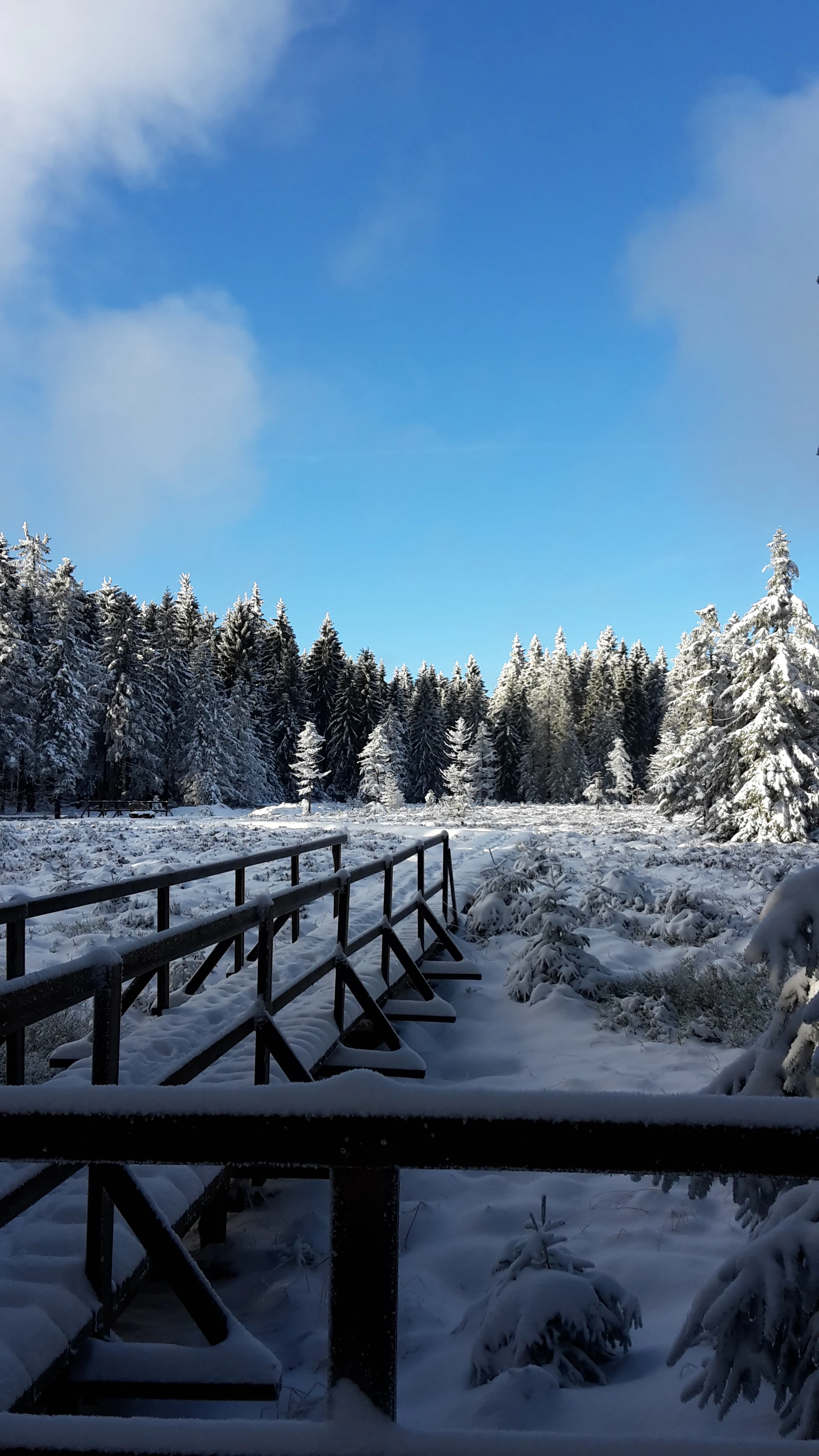
A wooden boardwalk bridge extends into a snow-covered forest clearing under a bright blue sky.
A snow-covered boardwalk trail winding through the forest at Schützenbergmoor.

Schützenbergmoor history and protected-area timeline

Schützenbergmoor was formally designated as a Naturschutzgebiet in 1967, recognizing its value as a largely intact raised bog within the Thuringian Forest. Decades of protection followed, during which the site preserved its peat-forming vegetation and associated microclimate.

In 2012, the area underwent restoration and was made physically accessible to the public for the first time through the construction of a wooden boardwalk path. The project allowed visitors to enter the sensitive bog environment on a controlled surface while leaving the underlying peat and moss communities undisturbed. Together, these two milestones, the 1967 protection designation and the 2012 restoration and boardwalk, form the main documented chapters of the site's modern history.

Schützenbergmoor landscape and geographic character

The landscape of Schützenbergmoor is defined by the subdued but distinct topography of a raised bog set within the Thuringian Forest highlands. The reserve sits at approximately 890 meters above sea level, surrounded by coniferous forest typical of the region's mid-to-high elevation zones.

The peatland itself does not form dramatic topography. Instead, it is recognizable as a slight, dome-shaped depression in the forest floor, where the surface is dominated by moss hummocks, patches of saturated peat, and a moisture-loving plant community. The visual experience is one of softness rather than grandeur: a low, quiet, spongy landscape enclosed by woodland and threaded by the wooden boardwalk that allows visitors to cross it. Atmospheric conditions, including frequent fog and sustained moisture, contribute significantly to the site's landscape identity, giving it an often muted, damp, and distinctly northern-bog ambiance despite its location in central Germany.
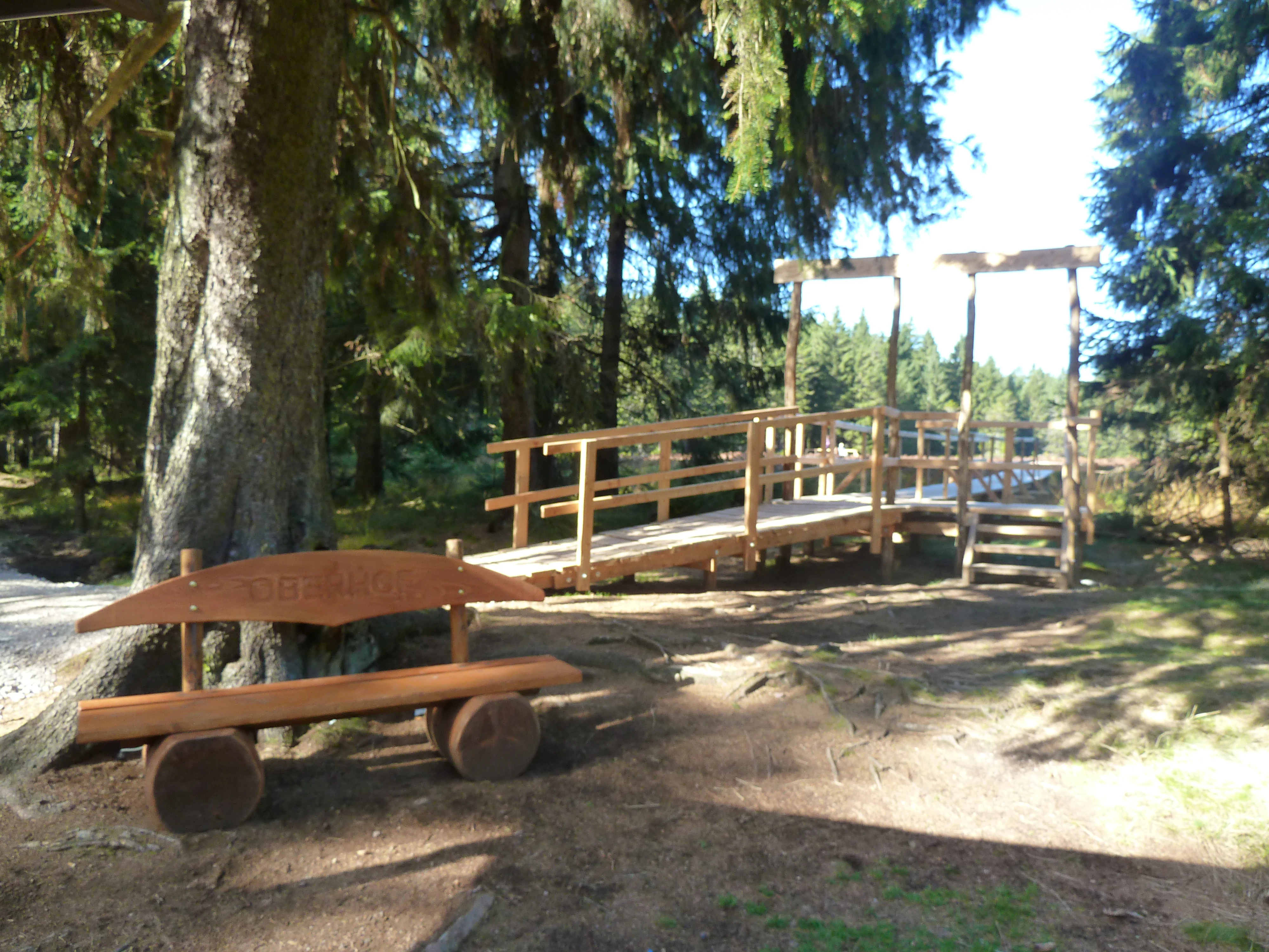
A rustic wooden bench sits under a large evergreen tree in front of a wooden boardwalk entrance, located in a forested bog area.
A wooden bench and a boardwalk entrance at the Schützenbergmoor nature reserve.

Schützenbergmoor ecosystems, habitats, and plant life

Ecologically, Schützenbergmoor is a textbook example of a central European Hochmoor, a raised bog fed primarily by precipitation rather than groundwater. The continuous saturation of the peat body, combined with acidic and nutrient-poor conditions, allows Sphagnum mosses to dominate and gradually build up the peat layer; in the Schützenbergmoor, peat thickness reaches around 2.5 meters.

Beyond the Sphagnum base, the bog supports the plant community typical of undisturbed raised peatlands: common sundew (Drosera rotundifolia) as a characteristic insectivorous species, cranberry-type plants in the Moosbeere group, and various cottongrass species, all of which are classic indicators of intact bog conditions. The surrounding forest adds a buffer of spruce-dominated woodland that protects the bog from edge effects and contributes to the litter and microclimate conditions that the peatland requires.

Because the reserve is both compact and heavily buffered, it maintains relatively stable humidity and temperature conditions even as the wider region experiences climate shifts. This combination of small size, focused habitat, and long protection makes the site ecologically significant in disproportion to its physical extent.

Schützenbergmoor wildlife and species highlights

Wildlife at Schützenbergmoor reflects the bog's character as a specialized, moisture-bound habitat. Small mammals find refuge there, including the common shrew-like Zwergspitz and the field vole, both of which thrive in the dense ground vegetation of mosses, grasses, and low shrubs.

Reptiles and amphibians are also characteristic of the site. Forest lizards inhabit the drier edges between the bog and the surrounding forest, while common frogs use the wetter parts of the peatland and its margins for breeding and foraging. Birdlife associated with similar central European raised bogs tends to favor the transitional woodland-bog edge rather than the open peat surface itself, and the reserve's location within a larger forested landscape gives it a broader forest fauna context as well.

Because of the fragility of the peatland, wildlife observation here is best approached as a quiet, low-impact experience from the boardwalk, with birds, amphibians, and the ever-present insect life underfoot providing the main points of interest.

Schützenbergmoor conservation status and protection priorities

Schützenbergmoor has been a designated nature reserve since 1967, making it one of the older small-scale protected peatland sites in the Thuringian Forest. Its long protection status has allowed the peat body and the associated vegetation to remain largely intact, preserving an ecologically faithful example of a raised bog within an otherwise heavily forested landscape.

The 2012 restoration and boardwalk project added a second conservation approach: public education and engagement alongside habitat protection. By giving visitors a clearly defined route through the bog, the reserve reduces the risk of informal trampling while increasing awareness of why peatlands matter, both as biodiversity hotspots and as slow-forming carbon stores.

At a broader scale, the reserve contributes to a network of Naturschutzgebiete within the Schmalkalden-Meiningen district and, more widely, to the conservation of central European raised bog ecosystems. These ecosystems are globally rare and increasingly threatened, which gives even a small site like Schützenbergmoor outsized conservation importance.

Schützenbergmoor cultural meaning and human context

Schützenbergmoor is embedded in the hiking and outdoor culture of the Thuringian Forest. The reserve sits along a well-used trail between the small Rondell viewing point near Oberhof, the historic Stein 16 boundary stone along the old Dietzel-Geba border line, the settlement of Adelsruh, and the town of Zella-Mehlis. This route has long been part of regional walking tradition, connecting historical points of interest in the central Thuringian highlands.

The area around Oberhof has long been associated with winter sports and outdoor recreation in Thuringia, and the bog fits into this broader cultural setting as a quieter, nature-focused counterpart to the more active sport tourism of the region. The site's boardwalk and interpretive signage also place it within the modern German tradition of making small yet ecologically valuable reserves accessible for public learning.

Top sights and standout views in Schützenbergmoor

Schützenbergmoor stands out as a small but unusually complete raised bog in the Thuringian Forest. Its highlights include the clearly visible Sphagnum and sundew community, the 2.5-meter peat profile beneath the bog surface, the cool, fog-rich highland microclimate at roughly 890 meters elevation, and the careful integration of public access through a boardwalk that protects the fragile peat while letting visitors experience the bog at close range.

Equally noteworthy is the reserve's long protection history, stretching back to 1967, and its restored 2012 boardwalk, which together make it both a conservation reference site and a regional outdoor destination.

Best time to visit Schützenbergmoor

Schützenbergmoor can be visited year-round, but the experience varies significantly with the seasons. Late spring and summer bring out the active growing season of the bog, with Sphagnum mosses lush and green, cottongrass in flower, and the small insectivorous plants of the sundew group most visible. The surrounding forest is also at its most inviting for hiking in this period.

In autumn and winter, the bog takes on a quieter, more atmospheric character. Cold temperatures and frequent fog, the latter a near-constant feature of the site with around 180 foggy days per year, lend the area a moody, northern-bog feel, and frost or snow can highlight the texture of the boardwalk and surrounding coniferous forest. Winter visitors should be prepared for damp, cold conditions and limited daylight. Spring and early autumn are generally the most balanced periods for combining comfortable hiking conditions with active-interest bog ecology.

Monthly climate preview

Long-term representative point measurements tracking monthly averages across the protected terrain

Schützenbergmoor Climate Normals, Annual Temperature and Precipitation Rhythm

Schützenbergmoor displays a measured annual temperature and precipitation rhythm spanning long-term averages from NASA Power climatology data. Examining the complete monthly climate normals reveals deeper variations in temperature extremes and precipitation distribution across the representative coordinate.
Annual mean8 °C
-2 °C18 °C
Jan-2°
Feb-1°
Mar
Apr
May12°
Jun16°
Jul18°
Aug18°
Sep13°
Oct
Nov
Dec-1°
Warmest month
July

18.2 °C

Coolest month
January

-1.8 °C

Wettest month
July

2.6 mm/day

Driest month
April

1.4 mm/day

Park location guide

Geography guide, regional context, and park location map for Schützenbergmoor

Schützenbergmoor park geography, regions, and map view in Germany

Understand where Schützenbergmoor sits in Germany through a broader geographic reading of the surrounding landscape, nearby location context, and its mapped position within the national park landscape.

How Schützenbergmoor fits into Germany

Germany is a federal republic in Western and Central Europe with a population of over 83 million across sixteen constituent states. It is Europe's largest economy by nominal GDP and a major global exporter and importer. The capital is Berlin, and the country borders Denmark, Poland, Czech Republic, Austria, Switzerland, France, Luxembourg, Belgium, and the Netherlands.

Wider geography shaping Schützenbergmoor in Germany

Germany is located in Western and Central Europe, spanning 357,022 km². It borders Denmark to the north, Poland and the Czech Republic to the east, Austria and Switzerland to the south, and France, Luxembourg, Belgium, and the Netherlands to the west. The country has coastlines on the Baltic Sea and North Sea to the north, with the Alps located in the southern region.

Map view of Schützenbergmoor

Use this park location map to pinpoint Schützenbergmoor in Germany, understand its exact geographic position, and read its mapped placement within the surrounding landscape more clearly.

Pigeon | © OpenStreetMap contributors

Location context for Schützenbergmoor

Thuringia

Explore the unique terrain, Sphagnum moss habitats, and protected wetland character of Schützenbergmoor.

Schützenbergmoor Photos and Landscape Scenery: Visualizing the Thuringian Highland Bog

Visual documentation reveals the quiet topography, saturated peat formations, and distinct highland environment defining Schützenbergmoor. Examining these protected habitats provides deeper insight into the delicate ecology of central German raised bogs.

A wooden boardwalk bridge extends into a snow-covered forest clearing under a bright blue sky.

A wooden boardwalk trail with railings extends into a marshy, forested nature reserve under a clear blue sky.

A rustic wooden bench sits under a large evergreen tree in front of a wooden boardwalk entrance, located in a forested bog area.

Park atlas

Compare adjacent wetland habitats and regional conservation landscapes in central Germany

Exploring Parks Near Schützenbergmoor and Surrounding Highland Protected Areas

Visitors exploring the highland raised bog at Schützenbergmoor can continue browsing nearby protected areas and forest reserves across the region. Extending the geographic comparison reveals broader patterns in upland peatland conservation and woodland terrain.
Nature reserveThuringia
About 3.4 km away#1 closest

Northwest

Saukopfmoor Nature Reserve: A Protected Raised Bog in Thuringia, Germany

Mapping peatland ecosystems within the Thuringian Forest

Saukopfmoor functions as a managed nature reserve in the Thuringian Forest, protecting valuable raised bog habitat that relies on specific high-elevation conditions. This site stands as a key example of peatland conservation in central Germany, revealing how stable mountain microclimates sustain specialized flora and complex hydrological processes across the regional landscape.

Area
0.346 km²
Established
1961
IUCN
IV
Climate
Temperate
Nature reserveThuringia
About 15 km away#2 closest

East

Veronikaberg Nature Reserve: Protected Muschelkalk Ridge and Forest Landscapes in Thuringia

Geographic overview of the southern Reinsberge range.

Veronikaberg functions as a critical nature reserve at the southeastern edge of the Ohrdrufer Platte. The landscape is defined by its Muschelkalk geology, which supports a unique microclimate for beech and yew forests. This record details the park boundaries and the terrain transitions that characterize this significant conservation site in central Germany.

Area
1.161 km²
Established
1961
Relief
Mountain
Water
No major water
Nature reserveThuringia
About 16 km away#3 closest

Northwest

Werra bis Treffurt mit Zuflüssen: Protected River and Floodplain Network in Thuringia

Mapping an extensive 191 kilometer Natura 2000 river corridor.

The Werra bis Treffurt mit Zuflüssen protected area serves as a vital ecological corridor in Thuringia. This site encompasses a complex mosaic of fast-flowing highland brooks, expansive floodplain meadows, inland salt sites, and rare dissolution lakes. Its geography bridges high-altitude source regions with lower river valleys, creating a distinctive landscape transect that supports essential freshwater habitats and rare aquatic species across the state.

Area
22.6 km²
Established
2008
IUCN
IV
Relief
Mixed relief
A soft watercolor illustration of a pond landscape with green reeds in the foreground, calm water in the midground, and distant rolling hills in the background.
Nature reserveIlm-Kreis
About 17 km away#4 closest

East

Ilmenauer Teichgebiet: Wetland Landscape and Protected Nature Reserve Atlas

Mapped pond system and geographic terrain in Ilm-Kreis

The Ilmenauer Teichgebiet nature reserve is defined by its six interconnected ponds, which create a significant wetland complex on the eastern edge of Ilmenau. Anchored by the Grosser Teich and supported by a gypsum basin, this area preserves both the history of medieval fish farming and critical habitats for waterbirds and amphibians, offering a unique look at the regional geography of central Thuringia.

Area
0.58 km²
Established
2002
IUCN
IV
Relief
Lowland
Nature reserveIlm-Kreis
About 19 km away#5 closest

Northeast

Gottesholz Nature Reserve: Mapping the Protected Landscapes of Ilm-Kreis, Thuringia

A study of shell-limestone woodland geography

Gottesholz serves as an essential nature reserve in Ilm-Kreis, defined by its porous shell-limestone bedrock and rich, diverse vegetation. This detailed view covers the physical landscape, the strict forest reserve status, and the ecological markers that define this distinctive central German site.

Area
0.593 km²
Established
1961
IUCN
IV
Nature reserveThuringia
About 23 km away#6 closest

East

Willinger Berg Nature Reserve: Exploring the Geography and Forested Terrain of the Ilm-Saale-Platte

A prominent muschelkalk limestone outlier in Thuringia

Willinger Berg stands out for its double-peaked silhouette and geological significance as a Zeugenberg. The 83.8 hectare nature reserve includes protected beech forests and karst features that define the slopes above the surrounding villages. This study traces its role as a regional landmark and its position within the complex watershed of the Ilm and Unstrut basins.

Area
0.838 km²
Relief
Mountain
Climate
Temperate
Scope
Terrestrial
A horizontal watercolor painting depicting a landscape with soft, rolling hills in the background, a band of mixed forest with hints of autumn foliage in the midground, and a winding stream flowing through wetland grasses in the foreground.
Nature reserveThuringia
About 24 km away#7 closest

East

Pennewitzer Teiche und Unteres Wohlrosetal Nature Reserve: Thuringian Wetland Geography

A dense mosaic of historic ponds, moor woodlands, and framing stream valleys.

Located in Thuringia, this nature reserve is defined by an extraordinary density of aquatic habitats. The terrain features historic pond groups and flooded forest pits linked by brook valleys. This protected area serves as an essential example of the interplay between cultural pond construction and natural wetland ecosystems in central Germany.

Area
4.246 km²
Established
2004
IUCN
IV
Nature reserveThuringia
About 26 km away#8 closest

Northwest

Werra-Aue zwischen Breitungen und Creuzburg: Protected Floodplain and River Geography

Nature reserve sanctuary in western Thuringia

Spanning over 33 kilometers of the Werra river, this protected floodplain is defined by its distinctive geological sinkholes, seasonal wetlands, and diverse bird habitats. Discover the layered conservation status and riparian terrain that mark this significant Thuringian nature reserve as a crucial node for European ecological connectivity.

Area
25.78 km²
Established
2007
IUCN
IV
Relief
Lowland

Common questions about visiting, size, designation, and location context for Schützenbergmoor

Schützenbergmoor FAQs for park facts, access, geography, and protected area context

Find quick answers about Schützenbergmoor, including protected-area facts, park geography, trail and visitor context, and how the park fits into its surrounding country and regional landscape.
MoriAtlas Explorer

Continue Your Protected Areas Search Across the Global Atlas

Deepen your exploration by continuing the structured search for national parks and protected areas worldwide. Utilize the comprehensive filtering capabilities to compare different conservation landscapes and refine your understanding of global park geography. Discover more about the distribution and characteristics of protected natural areas.

Global natural geography