

Mori Atlas logo
Nature reserveScottsdale Reserve

A critical restoration landscape and riparian corridor located in the southern tablelands of New South Wales

Scottsdale Reserve Nature Reserve: Exploring Protected Grassland and Murrumbidgee River Landscapes

Scottsdale Reserve functions as a major landscape-scale conservation site along the Murrumbidgee River in New South Wales. This protected nature reserve focuses on restoring critically endangered yellow box grassy woodlands and natural temperate grasslands. By managing river corridors and frost hollow vegetation, the reserve maintains essential habitat connectivity across the diverse tablelands terrain of southeastern Australia.

grassland conservationbox woodlandriver corridormurrumbidgeebush heritage australiaprivate nature reserve

Scottsdale Reserve

Nature reserve

Park overview

Structured park overview, official facts, and landscape profile for Scottsdale Reserve

Scottsdale Reserve park facts, protected area profile, and essential visitor context

Review the core facts for Scottsdale Reserve, including designation, size, terrain, visitor scale, habitats, and operating context in one park-focused overview.

About Scottsdale Reserve

Scottsdale Reserve occupies a transitional landscape between the river flats of the Murrumbidgee and the colder, frost-prone country of the southern New South Wales tablelands. The terrain combines open valley floors, frost hollow pockets, gently undulating grazing country, woody ridges, and a corridor of riverine habitat along the Murrumbidgee. From an ecological standpoint, the reserve matters because it captures a slice of habitat that was historically widespread but is now reduced to a small fraction of its original extent, and because it lies at a hinge point between alpine and lowland environments.

The property entered conservation ownership in 2006, when Bush Heritage Australia purchased it after more than 130 years of sheep grazing and limited cropping. The acquisition was strategic: roughly a quarter of the land had already been cleared, and the remainder was in a fragmented and degraded condition. Since then, the reserve has become a working laboratory for restoring grassy woodland and temperate grassland under Australian conditions, and a key node in regional efforts to link scattered remnants.

Scottsdale's importance extends beyond its boundaries because of its role in the Kosciuszko to Coast (K2C) initiative, a long-running program aiming to connect surviving habitat from the high country through to coastal New South Wales. The reserve's position on the Murrumbidgee corridor makes it a natural bridge in this larger network, supporting wildlife movement and allowing species such as woodland birds and native fish to maintain viable populations in a fragmented landscape.

Quick facts and research context for Scottsdale Reserve

Scottsdale Reserve is a 1,328-hectare nature reserve situated on the Murrumbidgee River in southern New South Wales, between Bredbo and Canberra. It is held in private ownership by Bush Heritage Australia, a national conservation organisation that purchased the property in 2006 to halt ongoing clearing and grazing pressures on threatened woodland and grassland habitat.

The reserve is significant for encompassing two nationally critically endangered ecological communities under the Australian Environment Protection and Biodiversity Conservation Act: yellow box grassy woodland and natural temperate grassland. Roughly a quarter of the property consists of cleared former agricultural land that is now the focus of an intensive ecosystem restoration program.

Scottsdale sits within lands associated with the Ngunawal people and forms a core link in the broader Kosciuszko to Coast (K2C) conservation initiative that aims to reconnect fragmented habitat across south-eastern New South Wales.

Protection and recognition

Documented protection scope and official international recognition records

Scottsdale Reserve Protection Status and Terrestrial Conservation Data

Terrestrial protection status and management data for Scottsdale Reserve provide a structured record of its conservation framework. Verified designation details and official recognition sources outline the foundational framework governing the protected area.

Protection details

Protection scope
Terrestrial
Transboundary protection
No
Park context

Deeper park guide and search-rich context for Scottsdale Reserve

Scottsdale Reserve history, landscape, wildlife, and travel context

Explore Scottsdale Reserve through its history, landscape character, ecosystems, wildlife, conservation priorities, cultural context, and seasonal travel timing in a structured park guide built for atlas discovery and search intent.

Why Scottsdale Reserve stands out

Scottsdale Reserve is best known for its role in recovering two critically endangered Australian ecological communities: yellow box grassy woodland and natural temperate grassland. Less than three percent of the original natural temperate grassland of the southern tablelands remains intact, and Scottsdale preserves what is left while also attempting to expand it through direct seeding and active restoration. The reserve is also recognised for its riparian rehabilitation work along the Murrumbidgee River. In partnership with the Upper Murrumbidgee Demonstration Reach, Scottsdale has helped establish a long habitat corridor aimed at supporting threatened native fish, including the Macquarie perch, trout cod, and Murray cod. Scottsdale combines rare ecological assets: remnant grassy woodland, tussock grassland, frost hollow vegetation, and a stretch of one of Australia's most ecologically important rivers, all on a single actively managed property.
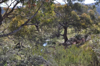
A view through Australian eucalyptus trees into a grassy woodland area, with a small stream visible in the midground.
Native woodland vegetation typical of the Scottsdale Reserve landscape.

Scottsdale Reserve history and protected-area timeline

The land now known as Scottsdale Reserve has a layered history of human use shaped by Aboriginal presence, European pastoral settlement, and modern conservation acquisition. The area lies within lands traditionally associated with the Ngunawal people, who are thought to have used the river flats and broader uplands seasonally. Aboriginal presence was tied to seasonal resources such as bogong moths and daisy yams, while the Murrumbidgee River supported fishing for species such as trout cod, and terrestrial game including brushtail possums, eastern grey kangaroos, and swamp wallabies.

European land use began in the late nineteenth century. From the 1870s until 2006, the property operated as a working pastoral holding dominated by sheep grazing, with some cropping. These activities removed large areas of native vegetation, degraded soils, fragmented habitat, and opened the door to invasive plants and animals. By the time conservation interests were focused on the property, roughly a quarter of the landscape had already been cleared, leaving remnant patches embedded in modified pasture.

In 2006, Bush Heritage Australia acquired Scottsdale to halt further degradation and to initiate ecological recovery. The acquisition aligned Scottstdale with the broader Kosciuszko to Coast program, which seeks to connect fragmented habitat running from the Australian Alps to the coast. Since purchase, the reserve has shifted from a primarily pastoral property to an active restoration landscape, with work focused on replanting native vegetation, controlling invasive species, stabilising gullies, and restoring riparian habitat along the Murrumbidgee.

Scottsdale Reserve landscape and geographic character

Scottsdale Reserve occupies a stretch of the southern New South Wales tablelands where the Murrumbidgee River has carved a valley through gently undulating country. The topography combines river flats and valley floors along the main watercourse with rising ground, frost hollow gullies, and small drainage lines such as Gungoandra Creek. The result is a mosaic of microhabitats in relatively close proximity: sunny grassy flats, cold air-draining frost hollows, dry ridges, and shaded creekside vegetation.

The reserve carries the imprint of more than a century of grazing. Much of the open country has lost its original tree cover, and introduced grasses now dominate large areas. Remnants of the pre-agricultural landscape survive as scattered patches of woodland with mature yellow box and red gum eucalypts, while the river corridor retains a band of native riparian vegetation interspersed with cleared banks.

The climate of the tablelands reinforces the visual character of the landscape. Cold winters, regular frosts, and relatively low rainfall favour hardy tussock grasses and open woodland rather than dense forest, shaping an environment where sky, frost, and grass dominate the visual rhythm of the land.

Scottsdale Reserve ecosystems, habitats, and plant life

The ecological identity of Scottsdale Reserve is defined by two nationally critically endangered plant communities: yellow box grassy woodland and natural temperate grassland. These communities once covered millions of hectares across New South Wales but have collapsed to a small percentage of their historical area because of clearing, grazing, fertiliser use, and weed invasion. Today, the reserve harbours both surviving remnants and active restoration sites aimed at rebuilding these vegetation types.

Yellow box grassy woodland at Scottsdale is characterised by an over-storey of yellow box and red gum eucalypts, a sparse mid-storey of shrubs from families such as Acacia, Grevillea, and Cassinia, and a ground layer of native grasses and herbaceous plants. Natural temperate grassland, by contrast, is an open landscape of perennial tussock grasses such as kangaroo grass, snow grass, river tussock, speargrass, wallaby grasses, and wild sorghum, supporting a distinctive wildflower assemblage.

Other vegetation communities on the reserve include scribbly gum and black cypress pine forest on drier ridges and tablelands frost hollow grassy woodland in cold pockets. The property is also notable for hosting a wild population of the silver-leafed mountain gum, a species now reduced to about ten known natural populations in Australia. An on-site nursery propagates key species including river tussock, silver wattle, yellow box, and silver-leafed mountain gum to support replanting of cleared areas. Experimental plots suggest that, with stock exclusion and weed control, replanted areas can achieve high survival and meaningful regeneration of native plant communities.

Scottsdale Reserve wildlife and species highlights

Scottsdale Reserve supports a diverse array of native fauna across its woodland, grassland, and riparian habitats. Surveys have recorded more than 140 animal species, including over 110 bird species, reflecting the range of vegetation types available on the property. Native mammals typical of the southern tablelands are present, including eastern grey kangaroos, swamp wallabies, and brushtail possums, which were historically important food resources for Aboriginal communities in the area.

The reserve is nationally significant for several threatened species. The striped legless lizard, a grassland reptile dependent on dense tussock cover, has been the focus of an active conservation program, with animals relocated from development sites in Canberra into protected trial areas at Scottsdale. Other threatened fauna recorded include Rosenberg's monitor, the speckled warbler, and the brown treecreeper.

The Murrumbidgee corridor running through the reserve is a stronghold for threatened native fish. Three protected fish species, the Macquarie perch, Murray cod, and trout cod, are present in the upper Murrumbidgee, and Scottsdale is involved in scientific work to understand their spawning behaviour, recruitment, and survival. Restored riparian habitat is expected to benefit woodland birds and other fauna by increasing the structural complexity of vegetation along the river.

Scottsdale Reserve conservation status and protection priorities

Scottsdale Reserve is one of the most ecologically significant private conservation properties in southern New South Wales. Its two nationally critically endangered ecosystems, yellow box grassy woodland and natural temperate grassland, place it at the centre of Australia's efforts to halt the collapse of temperate grassy landscapes. Less than three percent of the original natural temperate grassland of the southern tablelands remains intact, making Scottsdale's surviving grassland remnants and experimental restoration sites disproportionately valuable for national biodiversity outcomes.

The reserve is also a working site for landscape-scale conservation. Its location on the Murrumbidgee corridor and its alignment with the Kosciuszko to Coast (K2C) initiative mean that conservation work at Scottsdale contributes directly to connecting fragmented habitat across south-eastern New South Wales. Replanting programs along the river corridor, designed to improve habitat for native fish and woodland birds, are part of a broader effort to rebuild functional ecosystems at a regional scale.

Active management at Scottsdale focuses on a set of long-term ecological targets: restoring cleared box woodland areas by 2030, expanding native grassland cover by 20 percent by 2030, rehabilitating riparian and in-stream habitat along the Murrumbidgee by 2020, stabilising Gungoandra Creek and its tributaries by 2030, and supporting priority flora and fauna in dry sclerophyll forest areas by 2030. These objectives, pursued through volunteer-driven replanting, weed control, feral animal management, and erosion mitigation, make Scottsdale an important case study in large-scale ecological restoration on private land.

Scottsdale Reserve cultural meaning and human context

Scottsdale Reserve lies within lands historically attributed to the Ngunawal people, whose traditional use of the broader region included seasonal harvesting of bogong moths and daisy yams, fishing in the Murrumbidgee, and hunting of terrestrial mammals such as brushtail possums, eastern grey kangaroos, and swamp wallabies. Aboriginal presence in the area was closely tied to the river's resources, including species such as the once-abundant trout cod.

European land use began in earnest in the 1870s, when sheep grazing became the dominant activity across the Murrumbidgee valley and surrounding tablelands. Over more than a century, this pastoral history shaped the reserve: cleared land, eroded gullies, and modified vegetation communities visible today are direct legacies of grazing-era management. The 2006 transition to conservation ownership marked a turning point, shifting the land from a working pastoral property to a landscape focused on ecological and cultural heritage values.

Top sights and standout views in Scottsdale Reserve

Scottsdale Reserve combines rare and endangered ecological communities with a long stretch of the Murrumbidgee River, making it both a refuge for remnant vegetation and a focal point for landscape-scale restoration. Its yellow box grassy woodlands and natural temperate grasslands are among the most depleted vegetation types in Australia, and Scottsdale hosts both surviving patches and ambitious replanting programs aimed at rebuilding them.

Among its distinctive features are populations of the silver-leafed mountain gum, a species reduced to roughly ten wild populations nationally, and a Murrumbidgee corridor used by threatened native fish including the Macquarie perch, trout cod, and Murray cod. The reserve also functions as a key node in the Kosciuszko to Coast initiative, helping stitch together habitat fragments across south-eastern New South Wales.

Best time to visit Scottsdale Reserve

Scottsdale Reserve sits on the southern New South Wales tablelands, where winter brings cold nights, regular frosts, and occasional snow influence from the nearby high country, while summer tends to be warm and dry with the risk of thunderstorms. Spring is typically the most rewarding season for biodiversity, when native wildflowers and tussock grasses come into growth and grassland birds are most active.

Autumn can also be a productive time, with milder temperatures and softer light across the open valley floors. Wildlife observation opportunities tend to track these seasons rather than visitor-oriented considerations, given the reserve's focus on private conservation management rather than open public access.


Monthly climate preview

Long-term representative temperature and precipitation averages for New South Wales

Scottsdale Reserve Climate Normals and Monthly Weather Statistics

Scottsdale Reserve exhibits a measured annual temperature and precipitation rhythm spanning long-term averages from NASA Power coordinate sampling. Examining the complete twelve-month climatology profile reveals deeper monthly variations across the representative elevation point.
Annual mean12 °C
5 °C19 °C
Jan19°
Feb18°
Mar16°
Apr12°
May
Jun
Jul
Aug
Sep
Oct12°
Nov15°
Dec17°
Warmest month
January

19.5 °C

Coolest month
July

5 °C

Wettest month
February

3 mm/day

Driest month
May

1.3 mm/day

Park location guide

Geography guide, regional context, and park location map for Scottsdale Reserve

Scottsdale Reserve park geography, regions, and map view in Australia

Understand where Scottsdale Reserve sits in Australia through a broader geographic reading of the surrounding landscape, nearby location context, and its mapped position within the national park landscape.

How Scottsdale Reserve fits into Australia

Australia is a constitutional monarchy and federal parliamentary democracy comprising six states and ten territories. With a population of nearly 28 million, it is one of the world's most urbanised countries, with most people concentrated on the eastern seaboard. The country has a high Human Development Index and is known for its cultural diversity, ancient Aboriginal heritage, and unique wildlife.

Wider geography shaping Scottsdale Reserve in Australia

Australia occupies the entire Australian continent, the island of Tasmania, and numerous smaller islands. It is the world's flattest and driest inhabited continent, featuring vast deserts in the interior (the Outback), tropical rainforests along the eastern coast, and a coastline bordering the Indian and Pacific Oceans.

Map view of Scottsdale Reserve

Use this park location map to pinpoint Scottsdale Reserve in Australia, understand its exact geographic position, and read its mapped placement within the surrounding landscape more clearly.

Pigeon | © OpenStreetMap contributors

Location context for Scottsdale Reserve

New South Wales

Visual reference of native grasslands, river corridors, and restored tablelands habitats.

Scottsdale Reserve Photos, Scenery, and Protected Landscape Views

Visual records capture the undulating topography, endangered grassy woodlands, and river flats that define the protected character of Scottsdale Reserve. Detailed photography provides clear insight into the complex mosaic of frost hollows, riparian corridors, and restoration zones across the southern tablelands.

A view through Australian eucalyptus trees into a grassy woodland area, with a small stream visible in the midground.

A landscape view showing grassy hills in the foreground and a series of forested ridgelines receding into the background.

Park atlas

Compare regional tablelands geography and connected conservation corridors

Exploring Parks Near Scottsdale Reserve and Surrounding Protected Landscapes

Browse other parks and protected areas near Scottsdale Reserve to examine regional tablelands topography and connected river corridors. Extending the search helps trace broader ecological networks across south-eastern New South Wales conservation landscapes.
National parkAustralian Capital Territory
About 6.1 km away#1 closest

North

Namadgi National Park: Protected Landscape and Geographic Context in Australian Capital Territory

Explore the mapped boundaries and regional geography of this national park.

Namadgi National Park is a designated national park situated in the Australian Capital Territory. This dedicated page offers detailed information on its protected status, geographic features, and its role within the regional landscape atlas of Australia. Dive into the mapped terrain and understand the park's environmental significance and its contribution to the conservation landscape of the Australian Capital Territory.

Area
1,060.95 km²
Established
1984
IUCN
II
Relief
Mountain
Nature reserveNew South Wales
About 19 km away#2 closest

Northeast

Strike-a-Light Nature Reserve: Monaro Region Upland Protected Landscape Analysis

Essential conservation geography of southeastern New South Wales

Strike-a-Light Nature Reserve functions as a critical, high-protection status area dedicated to preserving native temperate grassland. Located in the Monaro region of New South Wales, the site provides a mapped window into the cool, grassy uplands and rolling tablelands of the Southern Tablelands, maintaining ecological integrity in a landscape defined by historically significant ground cover and open woodland remnants.

Area
4.07 km²
Established
2001
IUCN
Ia
Relief
Upland
Nature reserveNew South Wales
About 25 km away#3 closest

North

Queanbeyan Nature Reserve: Geography and Protected Area Atlas of the Southern Tablelands

Conserving threatened grassland and woodland habitats in New South Wales

Queanbeyan Nature Reserve sits on the undulating terrain of the Southern Tablelands, protecting essential remnants of Natural Temperate Grassland and Box-Gum Woodland. This site provides a critical refuge for endangered species within a landscape shaped by suburban and rural boundaries. Study the terrain and ecological features that define this significant conservation area near the Canberra region.

Area
0.67 km²
Established
1989
IUCN
IV
Relief
Upland
Nature reserveNew South Wales
About 27 km away#4 closest

Northwest

Scabby Range Nature Reserve: A Detailed Look at High Country Protected Landscapes and Terrain

Granite wilderness and subalpine ecology near the New South Wales border.

This reserve protects a dramatic 48 square kilometre block of the Kosciusko Uplands. Featuring boulder-strewn slopes, sphagnum-rich sedgelands, and tall montane eucalypt forests, the area represents a key node within the Australian Alps. Gain insight into the varied lithology and alpine flora that define this important nature reserve, from its granite pavements to the panoramic views at Mount Kelly.

Area
48.72 km²
Established
1982
IUCN
Ia
Relief
Mountain
National parkAustralia
About 31 km away#5 closest

Northwest

North East Island National Park: Australia's Protected Landscape Identity and Map Context

Discover mapped park boundaries and regional geographic setting.

North East Island National Park stands as a key protected area within Australia, offering users a detailed view of its geographic and landscape characteristics. This entry focuses on its designation as a national park, providing essential context for atlas-based exploration. Understand the specific mapped region and protected land attributes that contribute to its unique environmental geography, fostering a deeper appreciation for its place within the Australian continent.

National parkNew South Wales
About 32 km away#6 closest

Northeast

Tallaganda National Park: New South Wales Protected Area and Geographic Atlas Entry

Explore mapped boundaries and natural landscape context.

Tallaganda National Park serves as a vital protected landscape within the state of New South Wales, offering users a deep dive into its specific geographic identity and mapped territory. As a national park, its protected boundaries are crucial for understanding its role in regional geography and conservation. This detail page provides the foundation for atlas-style exploration, focusing on the park's unique landscape characteristics and its place within Australia's network of protected areas.

Access
Moderate access
Scope
Terrestrial
Water
Minor water
Forest
Mostly forested
Watercolor painting showing mountains, fields, and a river
National parkNew South Wales
About 33 km away#7 closest

West

Kosciuszko National Park: Australia's Highest Alpine Terrain and Mapped Protected Landscape

Discover unique glacial landscapes and geographic context in New South Wales.

Kosciuszko National Park represents the pinnacle of Australia's alpine geography, preserving the continent's only true alpine ecosystems. This extensive national park in New South Wales features dramatic glacial landforms, including its namesake Mount Kosciuszko, Australia's highest peak. Users can explore the park's mapped boundaries, surrounding natural terrain, and unique landscape features for a comprehensive understanding of this significant protected area.

Area
6,900 km²
Established
1944
IUCN
II
Visitors
3.3M annual
National parkNew South Wales
About 34 km away#8 closest

East

Deua National Park: New South Wales National Park Exploration and Map Context

Discover protected landscape boundaries and regional geography.

Deua National Park offers a focused lens into Australia's protected areas, specifically within the state of New South Wales. This page provides detailed geographic context, enabling users to trace the park's boundaries and understand its position within the regional atlas. Explore the mapped terrain and the protected landscape identity that defines Deua National Park as a key component of conservation efforts in the area, ideal for a structured understanding of protected natural spaces.

Area
1,220 km²
Established
1979
IUCN
Ib
Relief
Mountain

Common questions about visiting, size, designation, and location context for Scottsdale Reserve

Scottsdale Reserve FAQs for park facts, access, geography, and protected area context

Find quick answers about Scottsdale Reserve, including protected-area facts, park geography, trail and visitor context, and how the park fits into its surrounding country and regional landscape.
MoriAtlas Explorer

Continue Your Protected Areas Search Across the Global Atlas

Deepen your exploration by continuing the structured search for national parks and protected areas worldwide. Utilize the comprehensive filtering capabilities to compare different conservation landscapes and refine your understanding of global park geography. Discover more about the distribution and characteristics of protected natural areas.

Global natural geography