
Mori Atlas logo
Protected areaNatura 2000-område nr. 53 Sepstrup Sande, Vrads Sande, Velling Skov og Palsgård Skov

A diverse mosaic of glacial outwash plains, tunnel valleys, and rare inland dune systems in Region Midtjylland.

Natura 2000-område nr. 53 Sepstrup Sande, Vrads Sande, Velling Skov og Palsgård Skov Protected Area Landscape

Natura 2000-område nr. 53 Sepstrup Sande, Vrads Sande, Velling Skov og Palsgård Skov spans a significant portion of Central Jutland, defined by the distinct ice margin line from the last glaciation. This protected landscape encompasses a rare ecological mosaic including inland dunes, nutrient-poor Lobelia lakes, raised bogs, and extensive beech forest stands on moraine hills. Through its complex terrain of tunnel valleys and outwash plains, the area preserves critical natural habitats and hydrologic features that characterize the geography of Region Midtjylland.

Natura 2000EU Habitat Siteheathlandinland dunesraised bogLobelia lakes
A colorful digital illustration showing a tiered valley landscape with a central waterfall, coniferous trees, rolling hills, and a bright sun in the sky.

Natura 2000-område nr. 53 Sepstrup Sande, Vrads Sande, Velling Skov og Palsgård Skov

Protected area

Park overview

Structured park overview, official facts, and landscape profile for Sepstrup Sande, Vrads Sande, Velling Skov and Palsgård Skov

Sepstrup Sande, Vrads Sande, Velling Skov and Palsgård Skov park facts, protected area profile, and essential visitor context

Review the core facts for Sepstrup Sande, Vrads Sande, Velling Skov and Palsgård Skov, including designation, size, terrain, visitor scale, habitats, and operating context in one park-focused overview.

About Sepstrup Sande, Vrads Sande, Velling Skov and Palsgård Skov

Natura 2000 area no. 53 is one of the more ecologically layered protected landscapes in inland Denmark, distinguished by the way glacial history, heathland and forest come together in a single continuous territory. In the north and west the terrain flattens into broad outwash plains, while the east is shaped into a markedly hilly moraine landscape cut by tunnel valleys. This contrast gives the site its distinctive combination of windswept sandy heaths with inland dunes on one side, and deeply incised wooded valleys with clear lakes on the other.

The forest character of the area is substantial. Around two thirds of the land is wooded, with Palsgård Skov hosting both broadleaf and conifer forest and Velling Skov containing large areas of near-natural beech forest. One of the strongest ecological signatures of the site is the beech-on-mor-with-holly forest type, a priority habitat present here in unusually large stands exceeding 150 hectares. Conifer plantations such as Skærbæk, Snabegård and Kongsø supplement the forest cover and frame the more open heath and lake landscapes.

The open land holds some of the rarest habitats in the region. Inland dunes dominated by crowberry, juniper and grasses occupy sandy areas around Sepstrup Sande, Vrads Sande and Kolpendal Hede, while wet and dry heaths form extensive carpets around the same localities and continue south toward Kongsø Hede. Throughout the area, wet depressions contain hanging quag mires built by Sphagnum mosses, and Palsgård Skov in particular contains intact and partially degraded raised bogs, several of which are now overgrown by forest. In the southern part of the site, clusters of clear-water Lobelia lakes such as Hampen Sø and the Tingdalsøer reflect the calcium-poor, nutrient-poor water that defines this distinctive lake type in Denmark.

Quick facts and research context for Sepstrup Sande, Vrads Sande, Velling Skov and Palsgård Skov

Sepstrup Sande, Vrads Sande, Velling Skov and Palsgård Skov is a Danish Natura 2000 site carrying the official number 53 and the EU Habitat Area code H49, with an embedded Bird Protection Area coded F34. It covers about 5,572 hectares, of which roughly 1,537 hectares are state-owned, and crosses three municipalities in the Central Jutland region.

The protected area combines inland dunes with dry and wet heath, intact and degraded raised bogs, hanging quag mires, clear-water Lobelia lakes, spring mires, acidic and nutrient-rich grasslands, and a significant forest component dominated by beech and conifer plantation. Several of the constituent habitats, including inland dunes with crowberry and juniper, species-rich acidic grassland, raised bogs and alluvial forests, are listed as priority habitats within the EU Habitats Directive. Notable species include otter, great crested newt, pond bat, yellow saxifrage and the rare moss species known as blank sickle moss.

Park context

Deeper park guide and search-rich context for Sepstrup Sande, Vrads Sande, Velling Skov and Palsgård Skov

Sepstrup Sande, Vrads Sande, Velling Skov and Palsgård Skov history, landscape, wildlife, and travel context

Explore Sepstrup Sande, Vrads Sande, Velling Skov and Palsgård Skov through its history, landscape character, ecosystems, wildlife, conservation priorities, cultural context, and seasonal travel timing in a structured park guide built for atlas discovery and search intent.

Why Sepstrup Sande, Vrads Sande, Velling Skov and Palsgård Skov stands out

The site is best known for its concentrated mosaic of inland dunes, heaths and clear-water Lobelia lakes set against a forested glacial landscape. Kolpendal Hede, Sepstrup Sande, Vrads Sande and Kongsø Hede form the core heathland-and-dune complexes, while Palsgård Skov and Velling Skov carry extensive stands of beech forest, including the unusual habitat of beech on mor soils with holly. The area also holds the protected Tingdalsøer, a chain of clear, nutrient-poor lakes southeast of Kongsø Hede that exemplify Denmark's classical Lobelia lake type.
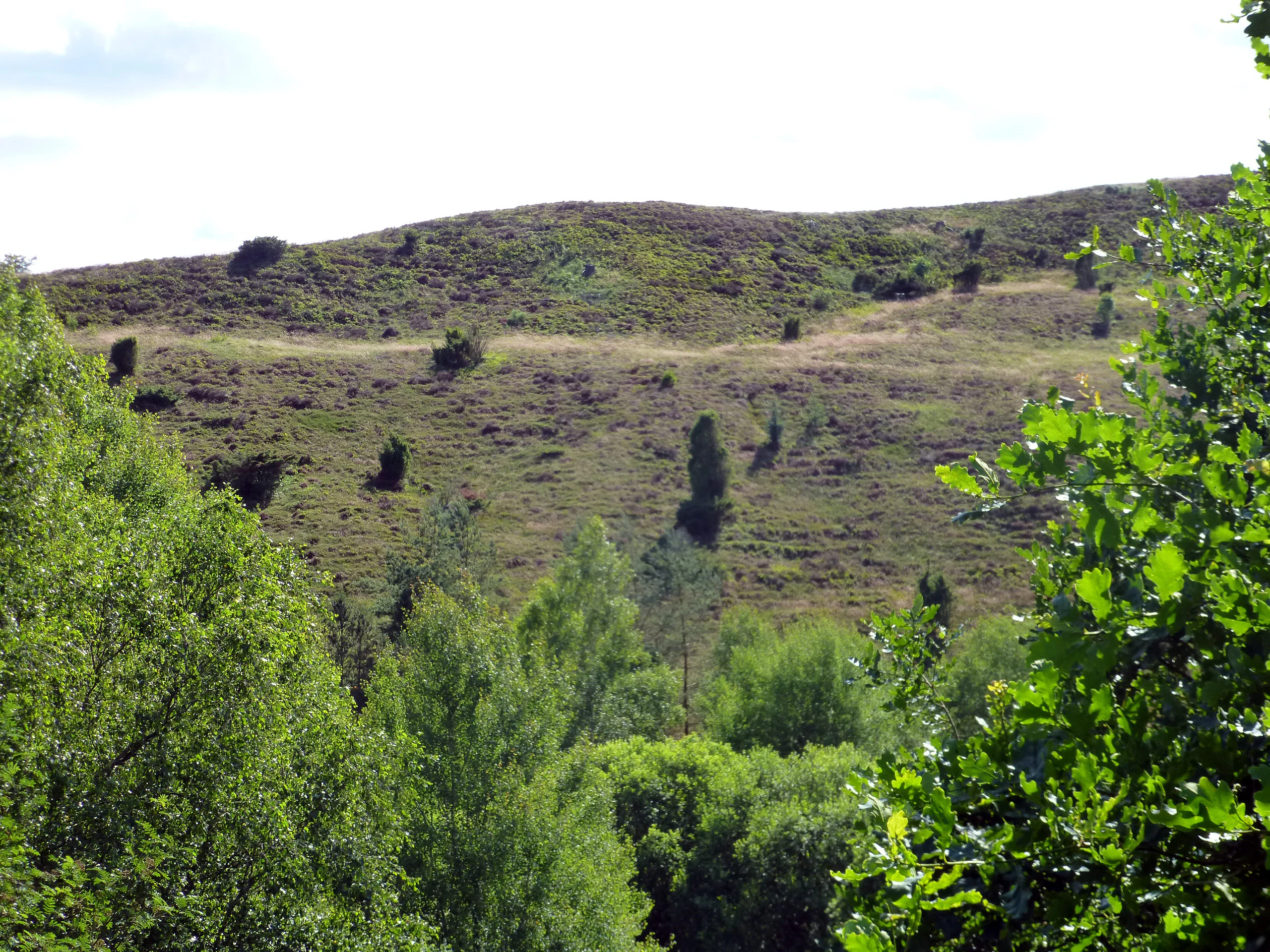
A grassy hill with sparse shrubs and trees in the background, framed by dense green deciduous foliage in the foreground.
Bøgelund Banke, a prominent sandy hill landscape in the Vrads Sande area.

Sepstrup Sande, Vrads Sande, Velling Skov and Palsgård Skov history and protected-area timeline

The protected landscape has been gradually assembled through a series of conservation steps dating back to the mid-twentieth century. Among the earliest formal protections were the conservation order covering Kolpendal Hede in 1954 and the order covering Vrads Sande in 1968, both securing open heathland that was otherwise vulnerable to afforestation and agricultural conversion.

Conservation continued throughout the 1970s and 1980s. The Salten Å valley, including the Bøgelund Banke and Svinsbjerg heathland areas, was designated in 1976, protecting a varied tunnel-valley landscape on the southern side of Salten Å. The Tingdalsøer area, enclosing four large Lobelia-type lakes (Rævsø, Grane Langsø, Kalgård Sø and Kongsø) along with the surrounding plantations and Kongsø Hede, was designated in 1987. A smaller conservation order also covers an area around Torup Sø.

Under the EU Habitats Directive the area was later designated as Habitat Site H49 and, in connection with important bird populations, as Bird Protection Area F34. A Natura 2000 plan was adopted in 2011, after which the municipalities of Silkeborg, Ikast-Brande and Horsens, together with the Danish Nature Agency, prepared statutory action plans for its implementation. The plan has since been renewed and developed in subsequent planning periods, and it is coordinated with the water management plans for the Randers Fjord and Ringkøbing Fjord catchments.

Sepstrup Sande, Vrads Sande, Velling Skov and Palsgård Skov landscape and geographic character

The terrain follows the old ice margin line that runs through central Jutland from the last glaciation. North and west of this line the surface is dominated by broad outwash plains, where sandy, relatively flat ground supports heathland and inland dune systems. East of the line the landscape rises into a strongly undulating moraine terrain, dissected by tunnel valleys that create steep slopes, basin lakes and wet hollows.

The heath-dominated sandy plains include the open, flat Kolpendal Hede in the western part of the site and the dune-and-heath complex of Sepstrup Sande and Vrads Sande, where inland dunes alternate with dry and wet heath. Southward the heathland continues through Kongsø Hede and the surroundings of the Tingdalsøer. In contrast, the eastern forest belt of Palsgård Skov and Velling Skov undulates over glacial moraine hills, while the stream valleys of Salten Å and its tributaries cut sharp wetland corridors into this hilly ground. Two larger nutrient-rich lakes, Halle Sø and Stigsholm Sø, occupy the southeastern river-valley landscape, while the southern half of the area holds numerous smaller clear-water, nutrient-poor lakes, including Hampen Sø and the protected chain of Tingdalsøer.

Sepstrup Sande, Vrads Sande, Velling Skov and Palsgård Skov ecosystems, habitats, and plant life

The site's ecological identity rests on a rare combination of open, dry inland habitats and wet, boggy nutrient-poor systems, embedded within a forested glacial matrix. The sandy plains support inland dunes with crowberry, juniper and grasses, alongside extensive dry and wet heaths that grade into wet depressions occupied by hanging quag mires and Sphagnum-dominated peatlands. These humid peatland systems include intact raised bogs, degraded raised bogs, active peat-cutting hollows, and forest-overgrown bogs, especially within Palsgård Skov.

The forest component is dominated by beech, often on acid mor soils, with notable occurrences of the uncommon beech-with-holly forest type. Velling Skov contains extensive near-natural beech stands, while smaller areas of oak-mixed forest and slender-stemmed oak scrub contribute to structural diversity. Alluvial alder-ash forests line the wet stream corridors, and conifer plantations such as Skærbæk, Snabegård and Kongsø add a managed forest element.

Wetland and aquatic habitats are equally central. The clear-water Lobelia lakes of the southern sector are calcium-poor and nutrient-poor, supporting characteristic isoetid vegetation and rare aquatic species, while Halle Sø and Stigsholm Sø in the southeast are richer and linked into the stream network. Spring-fed fens and mineral-rich flushes, particularly around Ansø Enge, anchor the northern part of the area, where a series of smaller streams rises to form Salten Å. Acidic and nutrient-rich grasslands, including species-rich acidic dry grassland, complement this pattern of habitats.

Sepstrup Sande, Vrads Sande, Velling Skov and Palsgård Skov wildlife and species highlights

The birdlife of the embedded Bird Protection Area F34 reflects the mixture of heath, forest and water that defines the site. Breeding species of conservation interest include honey buzzard, eagle owl, nightjar, kingfisher, black woodpecker, wood lark and red-backed shrike, all of which depend on different combinations of open heath, mature woodland, standing water or scattered trees within open land.

Among mammals, the most significant species is the otter, which uses the stream systems and lake chains as continuous habitat corridors. The pond bat, a species tied to older forest with suitable tree roosts, is also recorded. In the wetland systems, the great crested newt represents the amphibian interest of the area's ponds and wet depressions. Brook lamprey inhabits the smaller watercourses that rise in the northern valleys.

In the botanical register, yellow saxifrage marks the calcareous influence in certain spring-fed habitats, while the rare moss known as blank sickle moss is among the cryptogams that justify the site's inclusion in the EU Habitats Directive. Together these species underline the area's role as a refuge for fauna and flora that have become scarce elsewhere in the intensively cultivated Danish landscape.

Sepstrup Sande, Vrads Sande, Velling Skov and Palsgård Skov conservation status and protection priorities

As a Natura 2000 site the area contributes to the EU network of protected nature areas and carries responsibilities under both the Habitats Directive and the Birds Directive. It is designated as Habitat Site H49 and includes Bird Protection Area F34, and several of its habitats, including inland dunes with crowberry, juniper and grass-dominant forms, species-rich acidic dry grassland, raised bogs, alluvial alder-ash forest and beech forest with holly, are listed as priority habitats in the directive.

Conservation value comes from the unusually rich habitat diversity packed into a single connected landscape. The site combines open inland dunes, heath, raised bog, spring mires, nutrient-poor Lobelia lakes and substantial near-natural beech forest, all of which are habitat types that have declined sharply in Denmark and elsewhere in northwestern Europe. The continued presence of otter, great crested newt, pond bat and yellow saxifrage adds to this conservation significance.

Management is shared between the state and the municipalities of Silkeborg, Ikast-Brande and Horsens. Roughly a quarter of the site is state-owned, and a Natura 2000 plan adopted in 2011, with subsequent renewals, sets out binding actions implemented through municipal and Danish Nature Agency action plans. The terrestrial plan is coordinated with the water management plans for the Randers Fjord and Ringkøbing Fjord catchments, reflecting the importance of hydrology for the bog, fen and lake habitats.

Sepstrup Sande, Vrads Sande, Velling Skov and Palsgård Skov cultural meaning and human context

The site is woven into the traditional land-use fabric of central Jutland, where long-established heaths and forests have shaped local identity for centuries. Place names such as Sepstrup Sande, Vrads Sande and Kolpendal Hede reflect the historical use of these open sandy areas as commons and grazing heath, while the forest names Palsgård Skov, Velling Skov and the various plantations reflect a later phase of organized forest management, including the establishment of large conifer plantations in the nineteenth and twentieth centuries.

The abandoned Horsens-Silkeborg railway has been converted into a long-distance nature trail, the Naturstien Horsens-Silkeborg, which crosses the area and gives public access viewpoints such as the one looking out over Bøgelund Banke northeast of Vrads. Cultural heritage also touches the landscape through the network of protected conservation orders from 1954, 1968, 1976 and 1987, which were the original instruments by which Danish society decided to secure these heath, valley and lake landscapes against conversion.

Top sights and standout views in Sepstrup Sande, Vrads Sande, Velling Skov and Palsgård Skov

The diversity of habitats packed into one continuous Natura 2000 site is itself the strongest highlight, with a rare mix of inland dunes, wet and dry heath, intact and degraded raised bogs, hanging quag mires, Lobelia lakes, spring fens and substantial near-natural beech forest within a single territory.

Among individual features, the inland dunes and heaths at Kolpendal Hede, Sepstrup Sande and Vrads Sande stand out as representatives of a once more widespread Danish sandy-plain landscape, while the protected chain of clear-water Tingdalsøer is a textbook example of the Lobelia lake type. Large stands of the beech-with-holly forest habitat give the forest sector an unusually strong identity, and the conservation orders from 1954, 1968, 1976 and 1987 trace an unusually detailed protection history.

Best time to visit Sepstrup Sande, Vrads Sande, Velling Skov and Palsgård Skov

The site reads differently through the seasons because of its strong contrast between open heath and dune landscapes, lakes and forests. Late spring and summer bring heath flowers, dragonflies on the Lobelia lakes and active birdlife across the heaths and ponds, along with the species-rich grasslands at Ansø Enge and along Salten Å. Autumn highlights include warmer tones across the beech forest and cranberry displays on the heaths, while winter can emphasize the stark dune forms around Sepstrup Sande and Vrads Sande and the openness of Kolpendal Hede, as well as quiet visits to the clear-water lakes. The Naturstien Horsens-Silkeborg, which crosses part of the area on the old railway alignment, can be walked in any season.

Monthly climate preview

Long-term representative point measurements tracking monthly average temperature and precipitation cycles

Climate Normals and Annual Temperature Rhythm for Natura 2000-område nr. 53 Sepstrup Sande, Vrads Sande, Velling Skov og Palsgård Skov

Representative coordinates record measured monthly temperature ranges and precipitation patterns across the year within Natura 2000-område nr. 53 Sepstrup Sande, Vrads Sande, Velling Skov og Palsgård Skov. Devolved monthly climate normals provide structured baseline data for analyzing long-term environmental conditions across the protected terrain.
Annual mean8 °C
1 °C16 °C
Jan
Feb
Mar
Apr
May11°
Jun14°
Jul16°
Aug16°
Sep13°
Oct
Nov
Dec
Warmest month
July

16.5 °C

Coolest month
February

0.8 °C

Wettest month
October

2.9 mm/day

Driest month
April

1.6 mm/day

Park location guide

Geography guide, regional context, and park location map for Sepstrup Sande, Vrads Sande, Velling Skov and Palsgård Skov

Sepstrup Sande, Vrads Sande, Velling Skov and Palsgård Skov park geography, regions, and map view in Denmark

Understand where Sepstrup Sande, Vrads Sande, Velling Skov and Palsgård Skov sits in Denmark through a broader geographic reading of the surrounding landscape, nearby location context, and its mapped position within the national park landscape.

How Sepstrup Sande, Vrads Sande, Velling Skov and Palsgård Skov fits into Denmark

Denmark is a constitutional monarchy and Nordic country in Northern Europe. It is the southernmost of the Scandinavian countries, bordering Germany to the south, Norway to the north, and Sweden to the southwest. The country consists of the Jutland peninsula and an archipelago of islands, with Copenhagen as its capital and largest city. Denmark has a population of over 6 million and is characterized by flat, arable land, sandy coasts, and a temperate climate.

Wider geography shaping Sepstrup Sande, Vrads Sande, Velling Skov and Palsgård Skov in Denmark

Denmark occupies the Jutland peninsula and roughly 406 islands in Northern Europe. It is situated between the North Sea to the west and the Baltic Sea to the east. The country borders Germany to the south and is connected to Sweden via the Øresund Bridge. Denmark is predominantly flat terrain with low elevation, the highest point being Møllehøj at 170.86 meters.

Map view of Sepstrup Sande, Vrads Sande, Velling Skov and Palsgård Skov

Use this park location map to pinpoint Sepstrup Sande, Vrads Sande, Velling Skov and Palsgård Skov in Denmark, understand its exact geographic position, and read its mapped placement within the surrounding landscape more clearly.

Pigeon | © OpenStreetMap contributors

Location context for Sepstrup Sande, Vrads Sande, Velling Skov and Palsgård Skov

Region Midtjylland

Visual reference guide to inland dunes, glacial heaths, and ancient beech forest habitats

Natura 2000-område nr. 53 Sepstrup Sande, Vrads Sande, Velling Skov og Palsgård Skov Photos and Landscape Scenery

Protected area photography reveals the distinctive glacial terrain, rare inland dune systems, and clear water lakes defining Natura 2000-område nr. 53 Sepstrup Sande, Vrads Sande, Velling Skov og Palsgård Skov. Visual records help researchers and visitors examine habitat mosaics, undulating moraine forests, and open heathland character across Central Jutland.

A grassy hill with sparse shrubs and trees in the background, framed by dense green deciduous foliage in the foreground.

Park atlas

Compare surrounding Central Jutland protected landscapes, glacial terrain, and forest reserves

Exploring Parks Near Natura 2000-område nr. 53 Sepstrup Sande, Vrads Sande, Velling Skov og Palsgård Skov

Browse adjacent protected areas and regional reserves connected to the glacial moraines and sandy heathlands of Natura 2000-område nr. 53 Sepstrup Sande, Vrads Sande, Velling Skov og Palsgård Skov. Comparing these neighboring habitats provides a broader geographic perspective on Danish conservation landscapes and inland water systems.
A soft watercolor painting depicting a scenic landscape with distant purple hills, green forests, and a body of water in the foreground, set against a plain white background.
Nature reserveRegion Midtjylland
About 9 km away#1 closest

North

Silkeborgskovene Nature Reserve: Mapping the Forest and Lake Highlands of Central Jutland

Protected woodlands and freshwater mosaic in Denmark

Silkeborgskovene represents a profound example of Denmark's inland natural heritage, spanning a wide array of mature beech forests and clear lakes across the Søhøjland. This structured record provides geographic and habitat context for the reserve, detailing its role as a vital Natura 2000 protected area that preserves diverse ecosystems ranging from dry heathland to calcareous fens and unique brown-water aquatic environments.

Area
14.55 km²
Established
2011
Relief
Upland
Climate
Temperate
A minimalist watercolor painting showing rolling green hills and pink heather under a white sky.
Protected landscapeSilkeborg Municipality
About 15 km away#2 closest

Northeast

Sindbjerg og Stovbjerg: Protected Heath and Glacial Landscape near Silkeborg Municipality

Twin heather summits overlooking the central Danish lake district

Sindbjerg og Stovbjerg features two prominent summits that have remained open heathland since early conservation efforts in 1919. This protected landscape offers a rare perspective on the Gudenå tunnel valley, providing panoramic vantage points across Borre Sø and the surrounding forested ridges of Jutland.

Area
0.22 km²
Established
1910
Relief
Upland
Climate
Temperate
A horizontal watercolor illustration depicting a river flowing through a lush green valley with rolling hills in the background under a soft, warm sky.
Protected areaCentral Denmark Region
About 15 km away#3 closest

East

Salten Å Protected Area: Geography and Landscape Atlas of Central Denmark

Mapping inland river valleys and protected heathland corridors

Salten Å serves as a primary freshwater tributary and a protected natural corridor in the Central Denmark Region. This atlas entry provides insight into the valley's diverse terrain, spanning from the elevated inland heath at Sepstrup Sande to the forest-lined slopes and lake systems that characterize this unbroken Jutland habitat.

Water
Major water bodies
Panoramic watercolor illustration of a lake with green and pink trees and purple mountains in the background.
Protected areaCentral Denmark Region
About 16 km away#4 closest

East

Natura 2000-område nr. 52: Protected Lake and River Landscape in Central Denmark

Mapping freshwater habitats, mires, and sandy heath ridges.

Centered on the Salten Å river valley and the expansive waters of Mossø and Salten Langsø, this protected area represents one of the most significant freshwater networks in Denmark. The territory includes diverse habitat types ranging from calcareous fens and rare raised bogs to sandy dry heaths and Atlantic beech woodlands, creating a vital ecological corridor within the Central Denmark Region.

Area
44.7 km²
Established
2011
Nature reserveRegion Midtjylland
About 22 km away#5 closest

East

Natura 2000-område nr. 54 Yding Skov og Ejer Skov: Geography and Protected Area Context

Glacial plateau and forest reserve in Region Midtjylland

Natura 2000-område nr. 54 Yding Skov og Ejer Skov covers roughly 130 hectares of diverse Danish terrain. The reserve encompasses mature broadleaf forests and rare seepage habitats, mapped alongside significant Bronze Age archaeological sites. This protected landscape provides a clear view into the glacial geography and woodland conservation efforts characterizing eastern Jutland.

Area
1.3 km²
Established
2011
Relief
Upland
Climate
Temperate
Nature reserveRegion Midtjylland
About 29 km away#6 closest

Southwest

Mose ved Karstoft Å Protected Area: Landscape Geography and Wetland Mapping

Regional peatland habitat located in central Jutland, Denmark

Mose ved Karstoft Å represents a critical study in wetland restoration and habitat preservation. This small yet ecologically dense site features a complex terrain of Sphagnum mats, seasonal pools, and heathland, providing a vivid example of how post-industrial peat landscapes can foster specialist plant communities in the heart of Denmark.

Area
0.26 km²
Established
2011
Relief
Lowland
Climate
Temperate
A horizontal watercolor painting depicting a soft, rolling landscape with green grassy fields, small clusters of trees, and tall grasses in the foreground.
Protected areaCentral Denmark Region
About 37 km away#7 closest

Southeast

Horsens Fjord, havet øst for og Endelave: Protected Coastal Landscape and Map Context

Mapping island habitats, reefs, and fjord geography in Denmark

Examine the geographic composition of Horsens Fjord, havet øst for og Endelave, a significant Natura 2000 site. This protected area connects inland fjord waters to open Kattegat coastlines, featuring a chain of islands, tidal sand flats, and submerged stone reefs that define this distinct ecological region.

Area
458.23 km²
Established
2011
Relief
Lowland
Climate
Temperate
Protected areaCentral Denmark Region
About 38 km away#8 closest

Northwest

Natura 2000-område nr. 40 Karup Å, Kongenshus og Hessellund Heder Landscape and Maps

Central Denmark Region protected heath and river corridors

Investigate the natural terrain of this expansive Natura 2000 protected area. Analyze the distinct combination of the unregulated Karup Å river valley, rich fen systems, and the vast inland heathlands of Kongenshus and Hessellund that characterize this vital Central Denmark geographic feature.

Area
38.01 km²
Established
2011
Relief
Lowland
Climate
Temperate

Common questions about visiting, size, designation, and location context for Sepstrup Sande, Vrads Sande, Velling Skov and Palsgård Skov

Sepstrup Sande, Vrads Sande, Velling Skov and Palsgård Skov FAQs for park facts, access, geography, and protected area context

Find quick answers about Sepstrup Sande, Vrads Sande, Velling Skov and Palsgård Skov, including protected-area facts, park geography, trail and visitor context, and how the park fits into its surrounding country and regional landscape.
MoriAtlas Explorer

Continue Your Protected Areas Search Across the Global Atlas

Deepen your exploration by continuing the structured search for national parks and protected areas worldwide. Utilize the comprehensive filtering capabilities to compare different conservation landscapes and refine your understanding of global park geography. Discover more about the distribution and characteristics of protected natural areas.

Global natural geography