


Mori Atlas logo
Nature reserveSichuan Yading National Nature Reserve

Analyzing the terrain of sacred peaks, glaciated valleys, and high altitude meadows in Western Sichuan.

Sichuan Yading National Nature Reserve: Mapped Geography and Protected Alpine Landscapes

Sichuan Yading National Nature Reserve stands as a primary protected landscape within the eastern foothills of the Tibetan Plateau. This atlas entry provides a comprehensive look at the reserve, characterized by its distinctive triangular arrangement of snow clad summits, hanging glaciers, and high altitude alpine lakes like the Milk Lake and Five-Color Lake. Users can examine the vertical relief and the connection between the Litang River headwaters and the surrounding glacial cirques that define this unique ecological and cultural territory.

high-altitude mountainsglaciated peaksalpine meadowssacred mountainsTibetan PlateauUNESCO biosphere reserve
Vector-style illustration of a landscape with a meandering blue river flowing through a golden valley, bordered by evergreen and autumn-colored trees, with a large snow-covered mountain in the background under a clear sky.

Sichuan Yading National Nature Reserve

Nature reserve

Park overview

Structured park overview, official facts, and landscape profile for Sichuan Yading National Nature Reserve

Sichuan Yading National Nature Reserve park facts, protected area profile, and essential visitor context

Review the core facts for Sichuan Yading National Nature Reserve, including designation, size, terrain, visitor scale, habitats, and operating context in one park-focused overview.

About Sichuan Yading National Nature Reserve

Sichuan Yading National Nature Reserve is a high-elevation protected landscape in the eastern fringe of the Tibetan Plateau, in the southwestern corner of Sichuan Province. Although its official name frames it as a nature reserve, the area is widely recognized as a scenic mountain region, and the surrounding Yading scenic zone is one of the best-known natural attractions in western China.

The reserve is built around the upper reaches of the Litang River (also called the Gongga Yin'gou drainage in local usage), and its core is dominated by the Three Holy Mountains of Yading. These three peaks rise in close proximity but are separated by deep, glacially carved valleys, giving the landscape its characteristic "品" character from above: three distinct massifs positioned in a triangular layout. The vertical relief is exceptional within a compact area, with forested valleys below and glaciated summits above.

In addition to their geological drama, the mountains are central to Tibetan Buddhist pilgrimage culture. The Three Holy Mountains have long served as the focus of kora, or circumambulation pilgrimages, and the landscape around them is interwoven with monasteries, sacred lakes, and seasonal grazing grounds. This combination of ecological significance, high-altitude scenery, and living spiritual traditions gives the reserve a layered identity that goes well beyond simple conservation designation.

Today Yading is recognized at three levels: as a national nature reserve of China, as a UNESCO Man and the Biosphere Programme site, and as a national-level tourist attraction. Its protected status, biosphere recognition, and rising profile have turned it into one of the signature natural destinations of the Sichuan-Tibet borderland, both for travelers interested in mountain scenery and for researchers studying plateau ecology and traditional land use.

Quick facts and research context for Sichuan Yading National Nature Reserve

Sichuan Yading National Nature Reserve is located in Daocheng County, Garzê Tibetan Autonomous Prefecture, in southwestern Sichuan Province in western China. It was formally elevated to national nature reserve status in 2001, having previously passed through county, prefecture, and provincial protection steps starting in 1996. In July 2003 it was accepted into the UNESCO Man and the Biosphere Programme network.

The reserve covers roughly 3,800 square kilometers and surrounds the upper Litang River drainage, with elevations rising past the 6,000-meter mark on its central peaks. The landscape combines glacial landforms, alpine meadows, coniferous forest belts, and high-mountain lakes. The Three Holy Mountains form the symbolic and geographic heart of the protected area, while the broader reserve extends into surrounding valleys used for traditional pasture and pilgrimage circuits.

Protection and recognition

Documented terrestrial protection scope and historical designation data

Sichuan Yading National Nature Reserve Protection Status and Designation History

Sichuan Yading National Nature Reserve maintains a documented terrestrial protection status established in the year 2003. Structured records outline the official designation history and management scope associated with this protected natural area.

Protection details

Protection scope
Terrestrial
Designated year
2003
Transboundary protection
No
Park context

Deeper park guide and search-rich context for Sichuan Yading National Nature Reserve

Sichuan Yading National Nature Reserve history, landscape, wildlife, and travel context

Explore Sichuan Yading National Nature Reserve through its history, landscape character, ecosystems, wildlife, conservation priorities, cultural context, and seasonal travel timing in a structured park guide built for atlas discovery and search intent.

Why Sichuan Yading National Nature Reserve stands out

Yading is best known for the Three Holy Mountains, three isolated snow peaks rising in a triangular formation above the Litang River headwaters. Each peak is associated with a Tibetan Buddhist bodhisattva: Chenresig (compassion), Jampalyang (wisdom), and Chanadorje (courage). Locally they are collectively called Nyinchen Thangla Rigsum Gönbo. The reserve is also recognized for its high-altitude glacial lakes, including the turquoise-pearl Milk Lake and the multicolored Five-Color Lake, and for the dramatic alpine pastures of Luorong. These landscapes combine vertical relief of more than 3,000 meters, hanging glaciers, and deeply carved valleys, making the area one of the most visually distinct high-mountain protected regions in western Sichuan.
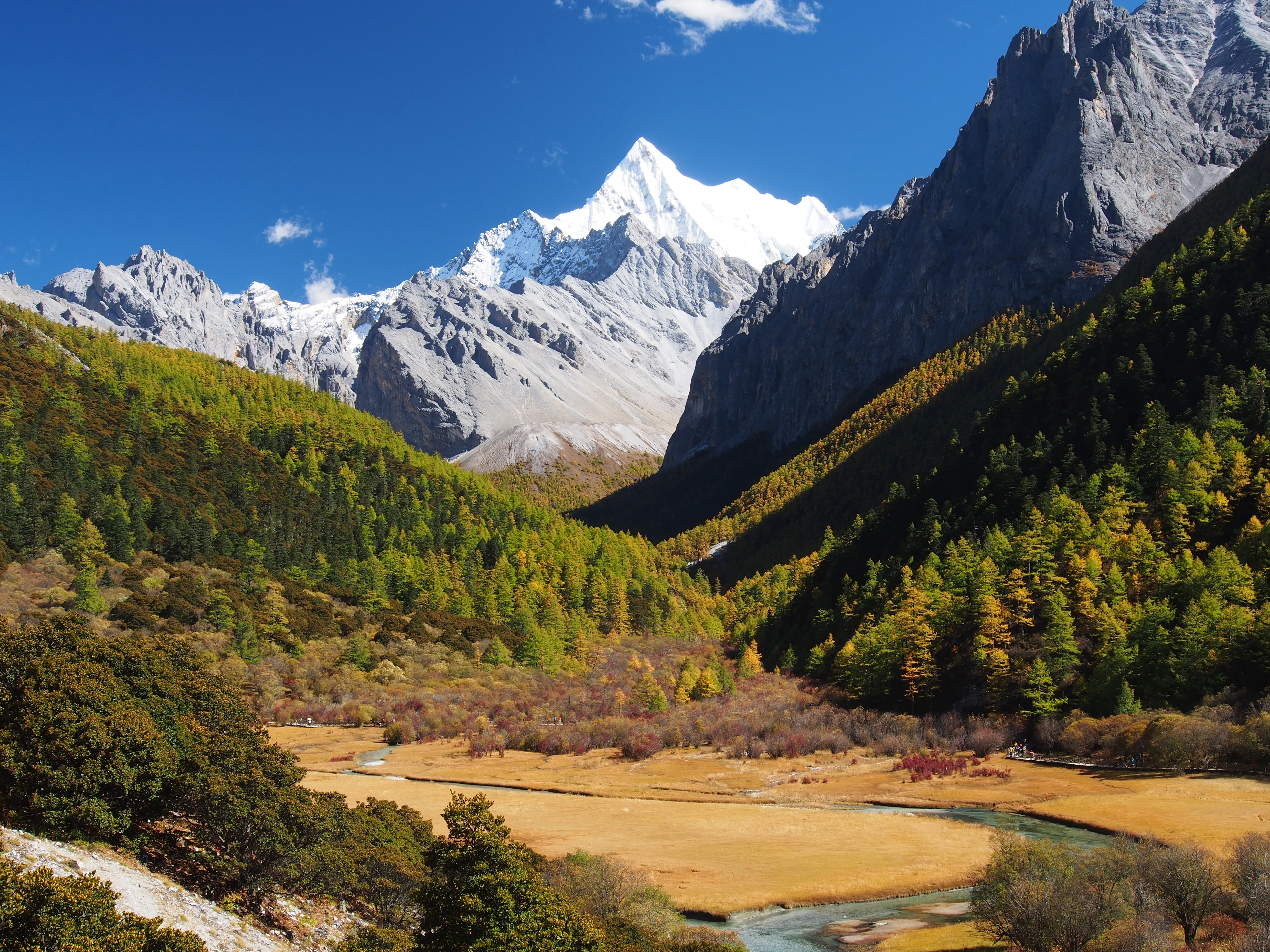
A towering, sharp, snow-covered mountain peak rises above a valley floor covered in golden-brown grasses and surrounded by coniferous forests during autumn.
The snow-capped peak of Chanadorje rising above the autumn colors of the Chonggu Grassland in Yading National Nature Reserve.

Sichuan Yading National Nature Reserve history and protected-area timeline

The protection history of Yading developed in clear stages over the second half of the 1990s. In March 1996, the Daocheng County government approved the area as a county-level nature reserve. About a year later, in May 1997, the Garzê Tibetan Autonomous Prefecture government elevated it to a prefecture-level nature reserve. By December of the same year, the Sichuan provincial government recognized Yading as a provincial-level nature reserve.

The decisive step came in June 2001, when the State Council of China approved the addition of Sichuan Yading National Nature Reserve to the national system of protected areas. This formal national designation reflected the area's growing recognition as an exceptional high-mountain ecosystem at the eastern edge of the Tibetan Plateau.

In July 2003, UNESCO accepted Yading into the Man and the Biosphere Programme, integrating it into the global network of biosphere reserves. This international recognition underscored the value of the area not only for its scenic mountains but also for its altitudinal ecological gradients, traditional land use, and cultural heritage. Since then, the reserve has been jointly managed by a designated national nature reserve administration and a tourism development company operating the scenic zone.

Sichuan Yading National Nature Reserve landscape and geographic character

The landscape of Yading is defined by sharp vertical contrasts over short horizontal distances. The lower valleys are forested with mixed coniferous stands, gradually giving way to alpine meadows, glacial moraines, exposed bedrock, and finally permanent ice and snow toward the upper elevations. The Litang River system and its tributaries cut deeply into the mountains, shaping narrow valleys that historically focused both ecological communities and traditional land use.

At the heart of the reserve stand the three sacred peaks. Chenresig reaches 5,998.5 meters, Jampalyang reaches 6,033.0 meters, and Chanadorje rises to 5,951.3 meters. Surrounding these central peaks are more than thirty additional horn-like summits, which together create a distinctive skyline of jagged alpine ridges and cirques.

Glacial features are prominent throughout the area. Hanging glaciers descend from the higher walls of Chanadorje into the valley above Luorong Pasture, while the flanks of Chenresig feed the small but visually striking high-altitude lakes. These include a turquoise-toned lake sometimes called Milk Lake, the multicolored Five-Color Lake higher on the mountain, and the small Zhoma Lhatso (Pearl Sea) on the northeast flank of Chenresig. The combination of glacial lakes, snowfields, hanging ice, and alpine meadow pastures gives Yading a landscape character often compared to classic high-mountain scenery found elsewhere in the greater Himalayan region.
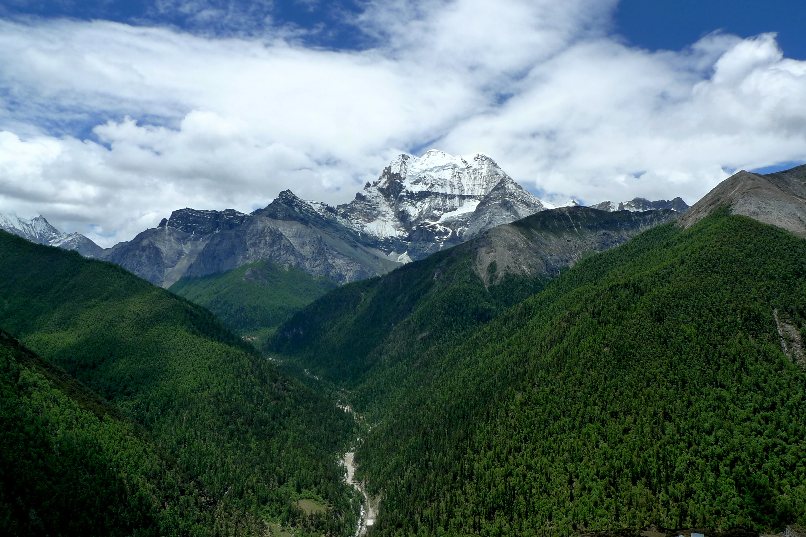
A wide scenic view of a forested alpine valley with a snow-capped mountain peak in the distance under a blue sky with white clouds.
A view of the verdant valley and Mount Xiannairi in Yading Nature Reserve.

Sichuan Yading National Nature Reserve ecosystems, habitats, and plant life

Ecologically, Yading represents a textbook example of vertical zonation on the eastern margin of the Tibetan Plateau. Within a relatively compact area, the reserve spans multiple life zones: riverine and forested valleys in the lower elevations, mixed coniferous forest belts, subalpine shrub and meadow zones, alpine pastures, and finally barren rock, ice, and snow at the highest elevations.

The forests are dominated by subalpine conifers typical of the Sichuan-Tibet borderland, including fir and spruce species that have adapted to long winters and short, intense growing seasons. Above the treeline, alpine meadows and rhododendron shrublands give way to cushion-plant communities and lichen-covered bedrock before transitioning into the glacial zone.

The reserve also protects important wetland and lake habitats. The high-altitude lakes around the Three Holy Mountains are not only scenic; they are also ecologically sensitive indicators of glacial meltwater dynamics and climate conditions on the plateau. Together these altitudinal belts create exceptionally high habitat diversity for a protected area of its size and contribute to the reserve's biosphere reserve designation.
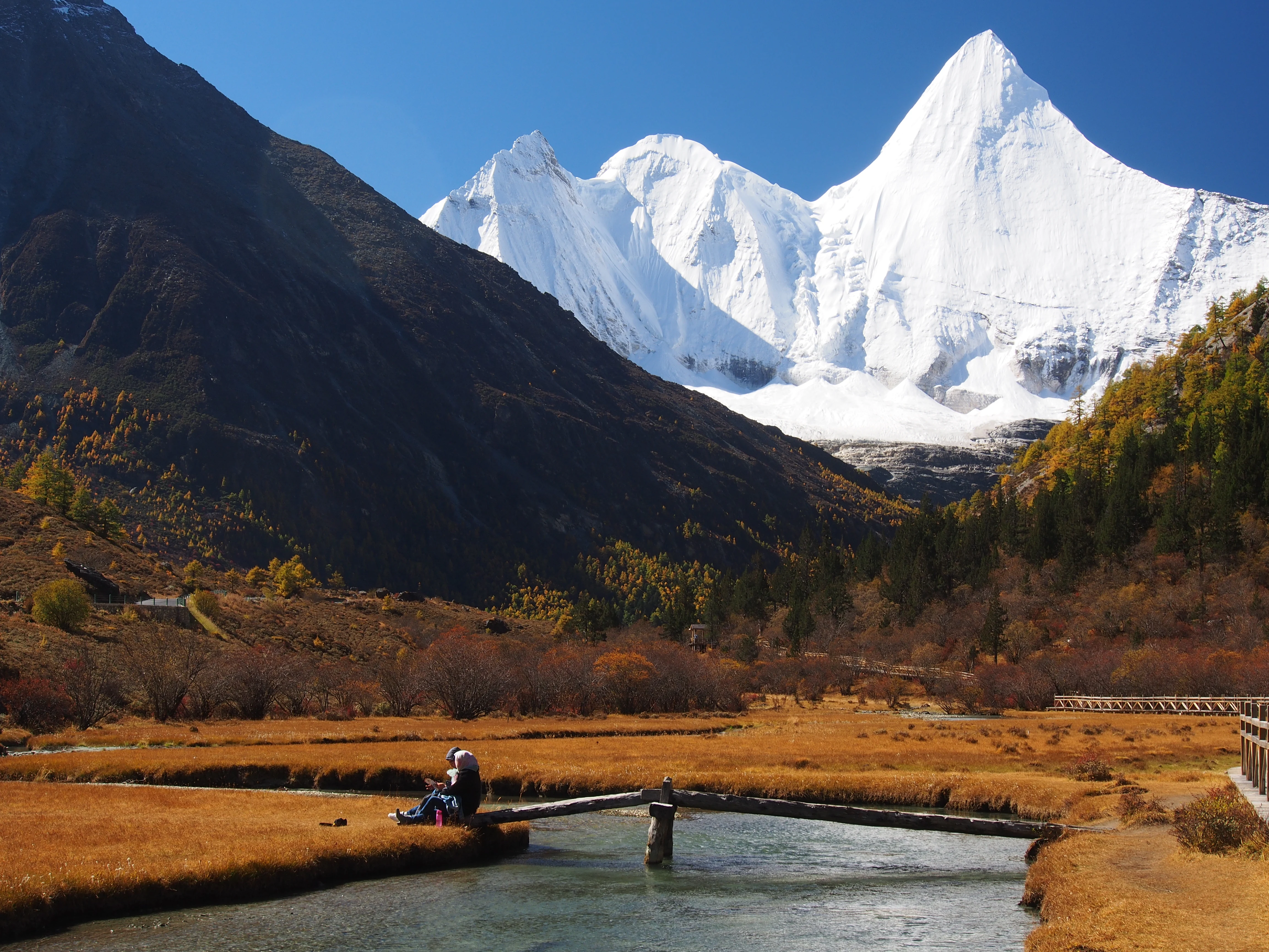
A snowy, pointed mountain peak rises above a golden-brown alpine meadow and a clear, flowing river, with a wooden bridge in the foreground.
A person sits on a small wooden bridge crossing a river with the snow-covered Jampelyang peak in the background at Yading Nature Reserve.

Sichuan Yading National Nature Reserve wildlife and species highlights

The wildlife of Yading reflects the altitudinal gradients that define the reserve. Lower forested valleys support typical western Sichuan and eastern Tibetan Plateau fauna, while the higher meadows and rocky zones harbor species adapted to cold, open environments. Among the larger mammals recorded in and around the reserve are blue sheep and various ungulates that use the alpine pastures above the treeline during the warmer months.

The diverse habitat structure also supports a rich bird community. Forest belts harbor typical Sino-Himalayan forest species, while alpine meadows, cliff faces, and lake margins provide habitat for raptors and high-country passerines adapted to open conditions. The high-altitude lakes around the Three Holy Mountains attract waterbirds seasonally and serve as important nodes in regional movement patterns.

Because the area combines substantial elevation variation with traditional pastoral use in surrounding valleys, the wildlife of Yading is best understood not in isolation but as part of a broader cultural landscape that has supported both livestock grazing and native fauna for generations. The national nature reserve designation reflects the importance of maintaining these ecological patterns alongside continuing local land use.

Sichuan Yading National Nature Reserve conservation status and protection priorities

Conservation significance in Yading operates on several overlapping levels. Domestically, the area has been part of China's national nature reserve system since 2001, which provides the highest tier of national-level habitat protection under Chinese law. Its inclusion in the national system recognizes the area's role as an exceptionally intact high-altitude ecosystem at the eastern fringe of the Tibetan Plateau.

Internationally, Yading's inclusion in the UNESCO Man and the Biosphere Programme in 2003 added another layer of recognition. Biosphere reserve status emphasizes not only strict protection of core zones but also the importance of buffering zones that can support sustainable human activity, in this case including traditional Tibetan pastoral practices and pilgrimage circuits associated with the Three Holy Mountains.

The reserve is also significant for water resources. The drainage at the heart of Yading feeds the upper Litang River, contributing to a major tributary system of the Yangtze basin. The condition of glaciers, glacial lakes, and alpine meadows within the reserve is therefore of broader regional interest, both as habitat and as part of the hydrological system of the Sichuan-Tibet plateau.

Sichuan Yading National Nature Reserve cultural meaning and human context

The cultural landscape around Yading is inseparable from Tibetan Buddhist tradition. The Three Holy Mountains are collectively known as Nyinchen Thangla Rigsum Gönbo, meaning the "Three Protectors of the Sacred Snow Mountains," and they are associated with three bodhisattvas: Chenresig (Avalokiteshvara), Jampalyang (Manjushri), and Chanadorje (Vajrapani). Each peak is identified with one of these figures, and the three together embody compassion, wisdom, and courage.

Pilgrimage practice has shaped the landscape for centuries. Local pilgrims historically completed a kora, or circumambulation, of Chenresig, a route that passes through pastoral zones, sacred gates, and high passes reaching roughly 4,700 meters. Villages such as Yading village, the ancient Chonggu Monastery area, and the seasonal grazing grounds of Luorong all form part of this cultural-geographic system.

Although modern tourism now plays a major economic role, traditional Tibetan pastoral use of the upper meadows, especially around Luorong, continues to coexist with the protected-area framework. The reserve thus represents a working example of how nature protection and living cultural practice can overlap in the high-altitude regions of the Tibetan Plateau.

Top sights and standout views in Sichuan Yading National Nature Reserve

The defining highlights of Yading revolve around its three sacred peaks and the alpine landscape that surrounds them. Chenresig, Jampalyang, and Chanadorje form a triangular skyline of snowy summits, each identifiable by its silhouette from different viewpoints within the scenic zone. The hanging glaciers of Chanadorje, the turquoise Milk Lake and multicolored Five-Color Lake, the Zhoma Lhatso (Pearl Sea) on the flank of Chenresig, and the broad alpine pastures of Luorong together make up the core visual identity of the area.

Equally important are the less-obvious highlights: the high-altitude wetlands, the coniferous forest belts, the seasonal grazing traditions, and the cultural pilgrimage circuit around Chenresig. These layered features give Yading depth beyond its iconic mountain photography. Recognition as both a national nature reserve and a UNESCO biosphere reserve confirms the area's ecological value, while the religious and pastoral heritage confirms its cultural weight.

Best time to visit Sichuan Yading National Nature Reserve

Yading's seasonal character is shaped largely by elevation and the Himalayan-influenced climate of the eastern Tibetan Plateau. The warmer months, roughly from late spring through autumn, are when alpine meadows are green, glacial meltwater lakes are full, and weather conditions are most favorable for accessing the higher scenic areas. This is also the season when traditional pastoral use of the upper meadows, especially around Luorong, is most visible.

In winter and early spring, much of the higher landscape is blanketed in snow, temperatures drop sharply, and access becomes more limited. Visitors during this period experience quieter conditions but also colder temperatures, frozen ground at high elevations, and reduced visibility of meadows and lakes under snow cover. Within the warmer season, the contrast between autumn yellows in the forests and the first heavy snows on the peaks is often considered one of the more visually distinctive windows for experiencing the reserve's scenery.
Monthly climate preview

Long-term representative point measurements tracking monthly temperature and precipitation patterns

Sichuan Yading National Nature Reserve Climate Normals and Annual Weather Rhythm

Representative coordinates record long-term monthly temperature and precipitation averages across the protected area, establishing a baseline annual rhythm from historical climatology data. Reviewing the complete twelve-month record provides deeper insight into temperature swings and precipitation distribution throughout the year.
Annual mean3 °C
-6 °C11 °C
Jan-6°
Feb-4°
Mar-1°
Apr
May
Jun11°
Jul11°
Aug10°
Sep
Oct
Nov-1°
Dec-4°
Warmest month
July

11 °C

Coolest month
January

-5.6 °C

Wettest month
July

5.6 mm/day

Driest month
December

0.1 mm/day

Park location guide

Geography guide, regional context, and park location map for Sichuan Yading National Nature Reserve

Sichuan Yading National Nature Reserve park geography, regions, and map view in China

Understand where Sichuan Yading National Nature Reserve sits in China through a broader geographic reading of the surrounding landscape, nearby location context, and its mapped position within the national park landscape.

How Sichuan Yading National Nature Reserve fits into China

China is a unitary communist state in East Asia, governed by the Chinese Communist Party. The country's capital is Beijing, while Shanghai is the largest city by urban population. China has 33 province-level divisions including provinces, autonomous regions, municipalities, and special administrative regions. The nation has a long history spanning thousands of years, with achievements including the invention of gunpowder, paper, printing, and the compass.

Wider geography shaping Sichuan Yading National Nature Reserve in China

China is located in East Asia, bordering fourteen countries: Russia, North Korea, Vietnam, Laos, Myanmar, India, Bhutan, Nepal, Pakistan, Afghanistan, Tajikistan, Kyrgyzstan, Kazakhstan, and Mongolia. The country spans diverse terrain including deserts, mountains, plateaus, and river valleys. Major river systems include the Yellow River and Yangtze River. The coastline stretches along the East China Sea, South China Sea, and Yellow Sea.

Map view of Sichuan Yading National Nature Reserve

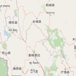
Use this park location map to pinpoint Sichuan Yading National Nature Reserve in China, understand its exact geographic position, and read its mapped placement within the surrounding landscape more clearly.

Pigeon | © OpenStreetMap contributors

Location context for Sichuan Yading National Nature Reserve

Garzê Tibetan Autonomous PrefectureSichuan

Visual exploration of sacred mountain peaks, alpine meadows, and glacial lakes

Sichuan Yading National Nature Reserve Photos and Landscape Scenery

Visual documentation captures the dramatic vertical relief, glaciated valleys, and high-altitude alpine habitats defining Sichuan Yading National Nature Reserve. Photographic records reveal the protected landscape character, sacred peaks, and remote terrain across the eastern Tibetan Plateau foothills.

A towering, sharp, snow-covered mountain peak rises above a valley floor covered in golden-brown grasses and surrounded by coniferous forests during autumn.

A line of colorful Tibetan prayer flags stretches across the foreground, framing a sharp, snow-covered mountain peak against a deep blue sky.

A wide scenic view of a forested alpine valley with a snow-capped mountain peak in the distance under a blue sky with white clouds.

A snowy, pointed mountain peak rises above a golden-brown alpine meadow and a clear, flowing river, with a wooden bridge in the foreground.

Park atlas

Compare surrounding regional geography and high-altitude protected areas across the eastern Tibetan Plateau

Parks Near Sichuan Yading National Nature Reserve and Protected Mountain Landscapes

Explore other protected natural areas and high-mountain reserves located near Sichuan Yading National Nature Reserve. Continuing past individual peaks provides broader geographic context for comparing alpine ecosystems and glacial terrain throughout the region.
Protected areaYunnan
About 187 km away#1 closest

West

Three Parallel Rivers of Yunnan Protected Areas: Mapped Geography and Protected Mountain Terrain

An atlas perspective on the Hengduan Mountain river corridor

The Three Parallel Rivers of Yunnan Protected Areas represents a unique geographic phenomenon in the Hengduan Mountains of China. The protected area is defined by deep, parallel river canyons, massive snow-capped peaks, and an exceptional vertical range of ecosystems. This atlas entry focuses on the regional layout, mapped mountain corridors, and the ecological significance of a site where three major rivers flow in close proximity for over 170 kilometers.

Area
17,000 km²
Established
2003
Relief
Mountain
Climate
Alpine
National parkChina
About 199 km away#2 closest

Northeast

Giant Panda National Park: China's Premier Panda Habitat and Protected Landscape

Mapped terrain and conservation significance in the mountains of western China.

Giant Panda National Park is a critically important protected area in China, established to conserve the primary habitat for the giant panda. This national park, spanning a vast mountainous region across Sichuan, Gansu, and Shaanxi, integrates numerous former reserves into a unified landscape. It serves as a vital sanctuary, protecting approximately 80 percent of the world's wild panda population and offering deep insights into the geographic distribution and ecological requirements of these endangered animals.

Area
27,134 km²
Established
2020
IUCN
II
Relief
Mountain
National parkKachin State
About 233 km away#3 closest

West

Hkakaborazi National Park: National Park Protected Landscape and Map Explorer

Explore its mapped boundaries and regional geography in Kachin State.

Hkakaborazi National Park serves as a critical protected area within Kachin State, offering a unique geographic profile for atlas and map exploration. This dedicated entry focuses on its identity as a national park, detailing its mapped landscape context and its role within the broader protected areas network. Understand the specific geographic features and boundaries that define this important natural landscape, essential for any detailed cartographic or regional study.

Area
3,810 km²
Established
1998
IUCN
II
Relief
Mountain
National parkMyanmar
About 285 km away#4 closest

Southwest

Emawbum National Park: Myanmar's Protected National Park Landscape Identity

Explore the geography and mapped boundaries.

Emawbum National Park offers a distinct focus for understanding protected areas within Myanmar. This detail page facilitates an exploration of its unique geographic setting and the mapped extent of its protected landscape. Discover what makes this national park a vital component of regional geographic context for atlas-based discovery and conservation insights.

IUCN
II
Nature reserveZhaotong
About 319 km away#5 closest

East

Dashanbao Black-necked Crane National Nature Reserve Geographic and Atlas Overview

Protected highland wetlands within the Zhaotong regional geography.

Dashanbao Black-necked Crane National Nature Reserve is a nationally significant protected area in Zhaotong, representing a rare high-elevation wintering habitat for migratory cranes. This rugged plateau landscape features shallow marshlands, alpine grasslands, and an interconnected system of lakes that support delicate highland ecological zones. Use this atlas resource to understand the park terrain and its formal conservation boundaries within the broader context of northeast Yunnan.

Area
192 km²
Established
1990
Relief
Mountain
Climate
Subtropical
Nature reserveSichuan
About 370 km away#6 closest

Northeast

Wolong National Nature Reserve: Mapping Sichuan's Rugged Mountain Protected Lands

A critical mountain nature reserve in the Qionglai range.

Delve into the geography of Wolong National Nature Reserve, a cornerstone of China's protected areas. This site offers insight into the vertical ecology of the eastern Qionglai Mountains, where steep river valleys and extensive bamboo forests characterize the transition toward the Tibetan Plateau. Access map-based insights into this essential wildlife corridor and its role in the larger regional landscape.

Area
2,000 km²
Established
1963
Relief
Mountain
Climate
Alpine
National parkArunachal Pradesh
About 391 km away#7 closest

West

Namdapha National Park: A National Park Detailed Entry for Geographic and Atlas Exploration

Explore mapped boundaries and regional landscape context in Arunachal Pradesh.

Namdapha National Park serves as a key protected area, offering a unique opportunity for structured geographic discovery. This entry focuses on its designation as a national park, providing detailed information about its mapped landscape, regional setting within Arunachal Pradesh, and overall protected territory context. It is designed to assist users in understanding the park's boundaries and its significance within a broader atlas framework.

Area
1,985 km²
Established
1983
IUCN
II
Relief
Mountain
Wildlife reserveArunachal Pradesh
About 422 km away#8 closest

West

Mehao Wildlife Sanctuary: Geography and Protected Habitat Mapping in Northeast India

A diverse reserve within the Eastern Himalaya biodiversity hotspot.

Mehao Wildlife Sanctuary protects an expansive landscape featuring rare orchid-rich forests and high-altitude lake ecosystems. By preserving terrain that spans subtropical valleys to temperate coniferous ridges, this reserve provides essential habitat for iconic species like the Mishmi takin and red panda. Examine the complex forest layers and geographic features that define this significant Indian protected area.

Area
281.5 km²
Established
1980
IUCN
II
Relief
Mountain

Common questions about visiting, size, designation, and location context for Sichuan Yading National Nature Reserve

Sichuan Yading National Nature Reserve FAQs for park facts, access, geography, and protected area context

Find quick answers about Sichuan Yading National Nature Reserve, including protected-area facts, park geography, trail and visitor context, and how the park fits into its surrounding country and regional landscape.
MoriAtlas Explorer

Continue Your Protected Areas Search Across the Global Atlas

Deepen your exploration by continuing the structured search for national parks and protected areas worldwide. Utilize the comprehensive filtering capabilities to compare different conservation landscapes and refine your understanding of global park geography. Discover more about the distribution and characteristics of protected natural areas.

Global natural geography

