

Mori Atlas logo
National parkSierra de Agalta National Park

Discover the mapped boundaries and natural terrain of this national park in Central America.

Sierra de Agalta National Park: Protected Landscape and Geographic Context in Honduras

Sierra de Agalta National Park stands as a significant protected area within Honduras, offering a unique lens through which to understand the nation's natural landscapes. As a designated national park, its mapped boundaries delineate a crucial zone for conservation and geographic study. This page provides detailed context for Sierra de Agalta National Park, focusing on its place within the country's atlas of protected lands and its intrinsic geographic identity.

cloud forestsmontane forestsmountain parksCentral American protected areasHonduras parkshighland ecosystems

Sierra de Agalta National Park

National park

Park overview

Structured park overview, official facts, and landscape profile for Sierra de Agalta National Park

Sierra de Agalta National Park park facts, protected area profile, and essential visitor context

Review the core facts for Sierra de Agalta National Park, including designation, size, terrain, visitor scale, habitats, and operating context in one park-focused overview.

About Sierra de Agalta National Park

Sierra de Agalta National Park protects a significant tract of Honduras' highland forest ecosystems within the Sierra de Agalta mountain range. The park's elevation range of 1,800 to 2,354 meters positions it within the montane forest zone, where moisture-laden clouds from the Caribbean coast create distinctive cloud forest conditions. This elevation gradient supports diverse habitat types and contributes to the park's ecological significance within Central America's protected area network. The park was established in 1987 as part of Honduras' commitment to preserving its natural heritage and maintaining biodiversity conservation across representative ecosystems. The protected area serves multiple conservation functions including habitat preservation, watershed protection, and maintenance of forest cover in a region where deforestation pressures have historically affected natural landscapes.

Quick facts and research context for Sierra de Agalta National Park

Sierra de Agalta National Park is situated in central Honduras, spanning approximately 208 square kilometers of mountainous terrain. The park was officially established in 1987 and protects an elevation zone between 1,800 and 2,354 meters, encompassing cloud forest and highland ecosystems. As a Category II protected area, it receives formal national park designation under Honduras' environmental protection framework.

Protection and recognition

Analyzing the official terrestrial protection framework and regional management scope

Sierra de Agalta National Park Protection Status and Terrestrial Boundaries

Geographic explorers can examine the documented terrestrial protection status and conservation framework governing Sierra de Agalta National Park. Reviewing official designation records helps researchers map regional preservation efforts and understand the formal boundaries of Central American protected areas.

Protection details

Protection scope
Terrestrial
Transboundary protection
No
Park context

Deeper park guide and search-rich context for Sierra de Agalta National Park

Sierra de Agalta National Park history, landscape, wildlife, and travel context

Explore Sierra de Agalta National Park through its history, landscape character, ecosystems, wildlife, conservation priorities, cultural context, and seasonal travel timing in a structured park guide built for atlas discovery and search intent.

Why Sierra de Agalta National Park stands out

Sierra de Agalta is best known for its high-altitude cloud forest environment and the distinctive mountainous landscape of the Sierra de Agalta mountain range. The park protects one of the higher elevation forest ecosystems in Honduras, characterized by its montane forest habitats, unique biodiversity associated with cloud forest zones, and its role in watershed protection for surrounding lowland areas.

Sierra de Agalta National Park history and protected-area timeline

Sierra de Agalta National Park was established on January 1, 1987, as part of Honduras' expanding network of protected areas during the late 20th century. The park's designation reflected growing recognition of the ecological importance of Honduras' highland forest zones and the need to preserve representative samples of the country's diverse ecosystems. The establishment of the park provided formal legal protection to the Sierra de Agalta mountain forest, creating a framework for ongoing conservation management and resource protection.

Sierra de Agalta National Park landscape and geographic character

The Sierra de Agalta National Park encompasses the rugged terrain of the Sierra de Agalta mountain range in central Honduras. The landscape is characterized by steep slopes, ridgelines, and deep valleys typical of mountain environments in Central America. The park's elevation gradient from 1,800 to 2,354 meters creates dramatic changes in topography and contributes to the visual diversity of the protected area. The mountainous character of the park distinguishes it from lower-elevation protected areas in Honduras and defines its ecological character.

Sierra de Agalta National Park ecosystems, habitats, and plant life

The park's high-elevation position within the montane forest zone defines its ecological character. The Sierra de Agalta mountains intercept moisture from Caribbean weather systems, creating conditions favorable for cloud forest development. These moist forest ecosystems support specialized plant communities adapted to high humidity and consistent cloud cover. The elevation range protected within the park encompasses transitional forest zones and represents habitats that are relatively limited in extent across Honduras.

Sierra de Agalta National Park conservation status and protection priorities

As an IUCN Category II protected area, Sierra de Agalta National Park receives recognition for its national-level conservation significance. The park protects forest ecosystems at elevations that are poorly represented in Honduras' protected area network. Cloud forest habitats at these altitudes contain unique biodiversity and play important roles in hydrological cycles, with forest cover helping to regulate water flow and maintain water quality in downstream watersheds. The park's establishment in 1987 provided formal protection to these montane forest ecosystems.

Top sights and standout views in Sierra de Agalta National Park

Sierra de Agalta National Park stands out as one of Honduras' higher-elevation protected areas, preserving cloud forest and montane forest ecosystems within the Sierra de Agalta mountain range. The park's elevation range of approximately 1,800 to 2,354 meters encompasses distinctive highland environments that support specialized ecological communities. Its designation as a national park since 1987 reflects its recognized importance within Honduras' conservation system.

Monthly climate preview

Analyzing long term temperature trends and precipitation cycles across the reserve

Sierra de Agalta National Park Monthly Climate and Weather Patterns

Long term meteorological records at the park's 674 meter representative elevation reveal warm peak temperatures in April and May, alongside a distinct wet season during the middle and late months of the year. Accessing the full historical dataset provides a comprehensive month by month breakdown of average minimums, maximums, and daily precipitation averages.
Annual mean23 °C
21 °C26 °C
Jan21°
Feb22°
Mar23°
Apr25°
May26°
Jun24°
Jul24°
Aug24°
Sep24°
Oct23°
Nov22°
Dec21°
Warmest month
May

25.5 °C

Coolest month
January

21 °C

Wettest month
October

5 mm/day

Driest month
April

0.9 mm/day

Park location guide

Geography guide, regional context, and park location map for Sierra de Agalta National Park

Sierra de Agalta National Park park geography, regions, and map view in Honduras

Understand where Sierra de Agalta National Park sits in Honduras through a broader geographic reading of the surrounding landscape, nearby location context, and its mapped position within the national park landscape.

How Sierra de Agalta National Park fits into Honduras

Honduras, officially the Republic of Honduras, is a Central American nation with a predominantly Mestizo population. It gained independence in 1821 and operates as a unitary presidential republic. The country faces significant economic challenges, with over 70% of its population living in poverty, though it possesses valuable natural resources including minerals, coffee, and tropical fruits.

Wider geography shaping Sierra de Agalta National Park in Honduras

Honduras is located in Central America, bordering Guatemala to the west, El Salvador to the southwest, Nicaragua to the southeast, the Pacific Ocean to the south at the Gulf of Fonseca, and the Caribbean Sea to the north at the Gulf of Honduras. The terrain includes mountainous regions and coastal lowlands.

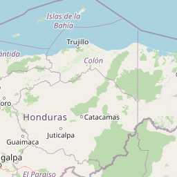
Map view of Sierra de Agalta National Park

Use this park location map to pinpoint Sierra de Agalta National Park in Honduras, understand its exact geographic position, and read its mapped placement within the surrounding landscape more clearly.

Pigeon | © OpenStreetMap contributors

Location context for Sierra de Agalta National Park

Olancho
Park atlas

Browse the regional geography of protected areas in Honduras, comparing similar mountain and cloud forest ecosystems.

Explore More National Parks and Protected Areas Adjacent to Sierra de Agalta National Park

Beyond Sierra de Agalta National Park, explore other national parks and protected areas across the surrounding Honduran mountain ranges and cloud forest regions. This structured geographic view allows for direct comparison of their diverse highland ecosystems and conservation landscapes, enhancing your atlas-based discovery.
National parkHonduras
About 31 km away#1 closest

Southeast

Patuca National Park National Park: Understanding its Mapped Protected Boundaries and Honduran Geography

Explore the protected landscape and regional setting of this Honduran park.

Patuca National Park is an important protected area within Honduras, offering a unique opportunity to study its geographic features and conservation significance. As a national park, it provides a critical anchor for understanding regional landscape patterns and mapped protected boundaries in Central America. This entity within the MoriAtlas helps users grasp the specific geographic context and natural terrain associated with Patuca National Park, facilitating detailed atlas-based exploration of its protected status and landscape character.

Area
3,755.84 km²
Established
1999
IUCN
II
Scope
Terrestrial
Biosphere reserveGracias a Dios Department
About 37 km away#2 closest

Northeast

Río Plátano Biosphere Reserve: Protected Geography and Watershed Mapping in Honduras

A sprawling conservation landscape in Gracias a Dios Department

Río Plátano Biosphere Reserve protects one of the last major tracts of undisturbed tropical rainforest along the Central American Caribbean coast. This vast area spans diverse physiographies including brackish coastal lagoons, freshwater mangrove systems, and steep mountain ridges reaching over 1,300 meters. The geography is defined by the Río Plátano watershed, which serves as a vital corridor for endangered species and encompasses significant archaeological sites within its deep forest interior.

Area
5,250 km²
Established
1982
IUCN
II
Relief
Mixed relief
National parkLa Unión
About 89 km away#3 closest

West

La Muralla National Park: Honduras National Park Geography and Mapped Boundaries

Explore the protected landscape and regional context.

La Muralla National Park represents a significant protected landscape within Honduras, offering valuable geographic data for atlas exploration. As a national park, its mapped boundaries and regional setting are key to understanding its conservation significance. This entry provides structured insight into the park's physical characteristics and its place within the broader Honduran geography, ideal for detailed landscape analysis.

Area
210.35 km²
Established
1993
IUCN
II
Scope
Terrestrial
Biosphere reserveJinotega Department
About 90 km away#4 closest

Southeast

Bosawás Biosphere Reserve: Mapping Tropical Rainforest Landscapes and Regional Geography

Extensive primary forest and mountainous terrain in Nicaragua

Examine the geographic layout and protected boundaries of Bosawás Biosphere Reserve. Spanning nearly 20,000 square kilometers across Jinotega Department, this massive biosphere reserve includes the Saslaya massif and essential watersheds, serving as a critical study of tropical rainforest preservation and complex highland topography.

Area
20,000 km²
Established
1997
IUCN
IV
Relief
Mountain
National parkColón Department
About 96 km away#5 closest

North

Capiro Calentura National Park: Honduran National Park Atlas and Protected Landscape

Discover mapped geography and protected area context in Colón Department.

Access detailed geographic information and mapped boundaries for Capiro Calentura National Park, a key protected area within Honduras' Colón Department. This entry offers an atlas-style perspective on the park's landscape and its regional setting, supporting structured discovery of national parks and conservation lands.

Area
80.82 km²
Established
1992
IUCN
II
Climate
Tropical
National parkAtlántida Department
About 113 km away#6 closest

Northwest

Pico Bonito National Park: Honduran National Park with Mapped Protected Boundaries

Explore its geographic setting and protected landscape identity.

Pico Bonito National Park represents a vital protected area within Honduras, situated in the Atlántida Department. This canonical page focuses on its precise geographic features and the extent of its protected landscape. Users can engage with detailed map-based information and understand the park's significance within the broader context of Honduran geography and conservation atlas data.

Area
564.3 km²
Established
1987
IUCN
II
Relief
Mountain
National parkHonduras
About 131 km away#7 closest

West

Montaña de Yoro National Park: Honduran National Park Atlas and Protected Landscape Exploration

Understanding its mapped boundaries and regional geography.

This card details Montaña de Yoro National Park, a designated national park in Honduras, offering a focused look at its protected landscape. It provides essential geographic context, helping users to understand the park's mapped boundaries and its significance within the broader atlas of Honduran protected areas. Explore the specific terrain and regional setting that define Montaña de Yoro National Park.

Area
154.8 km²
Established
1987
IUCN
II
Relief
Mountain
National parkFrancisco Morazán Department
About 161 km away#8 closest

Southwest

La Tigra National Park: Mapped Protected Landscape in Francisco Morazán Department, Honduras

Explore its geography and protected area context.

La Tigra National Park serves as a key protected area within the Francisco Morazán Department, offering rich opportunities for geographic and landscape discovery. This national park's specific mapped boundaries and regional context are vital for understanding its role within Honduras's protected lands. Engage with its geography to appreciate the unique characteristics of this important natural landscape.

Area
238.21 km²
Established
1980
IUCN
II
Relief
Mountain

Common questions about visiting, size, designation, and location context for Sierra de Agalta National Park

Sierra de Agalta National Park FAQs for park facts, access, geography, and protected area context

Find quick answers about Sierra de Agalta National Park, including protected-area facts, park geography, trail and visitor context, and how the park fits into its surrounding country and regional landscape.
MoriAtlas Explorer

Continue Your Protected Areas Search Across the Global Atlas

Deepen your exploration by continuing the structured search for national parks and protected areas worldwide. Utilize the comprehensive filtering capabilities to compare different conservation landscapes and refine your understanding of global park geography. Discover more about the distribution and characteristics of protected natural areas.

Global natural geography
