
Why Siete Luminarias stands out
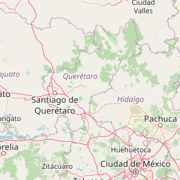
Siete Luminarias is best known as a tightly grouped cluster of seven extinct volcanic craters, or maars, set amid the agricultural plains of the Bajío in Guanajuato. The flat-floored, steep-walled depressions are textbook examples of phreatomagmatic volcanism, where rising magma interacted with groundwater to produce broad, shallow craters instead of tall cone-shaped peaks. Their compact arrangement, all within relatively easy reach of one another around Valle de Santiago, makes Siete Luminarias unusual among Mexican volcanic landscapes. The craters historically doubled as crater lakes, contributing to the area's reputation as a regional scenic and cultural landmark. Today, they are recognized primarily for their geological character, their role within the larger Michoacán, Guanajuato volcanic field, and their status as a protected natural monument.
Siete Luminarias history and protected-area timeline
Siete Luminarias entered formal environmental protection relatively recently, in 1997, when the Mexican government declared the group of seven volcanic craters a natural monument. The designation covered an area of about 89.28 square kilometers around Valle de Santiago, placing the volcanoes under the administration of the National Commission of Natural Protected Areas.
Prior to this declaration, the craters were primarily considered a local landmark and a source of regional identity for Valle de Santiago and surrounding communities. Some of the maars once held crater lakes that contributed to local livelihoods and folklore, though these lakes were lost during the twentieth century as groundwater extraction in the Lerma basin intensified. The 1997 protection status marked a turning point, framing the craters not only as cultural references but as geological assets worthy of national recognition.
The natural monument status also coincided with growing concern about the broader Bajío region's hydrological balance. By placing Siete Luminarias within a formal protection framework, authorities acknowledged both the geological importance of the maar fields and the environmental pressures affecting the surrounding agricultural landscape.
Siete Luminarias landscape and geographic character
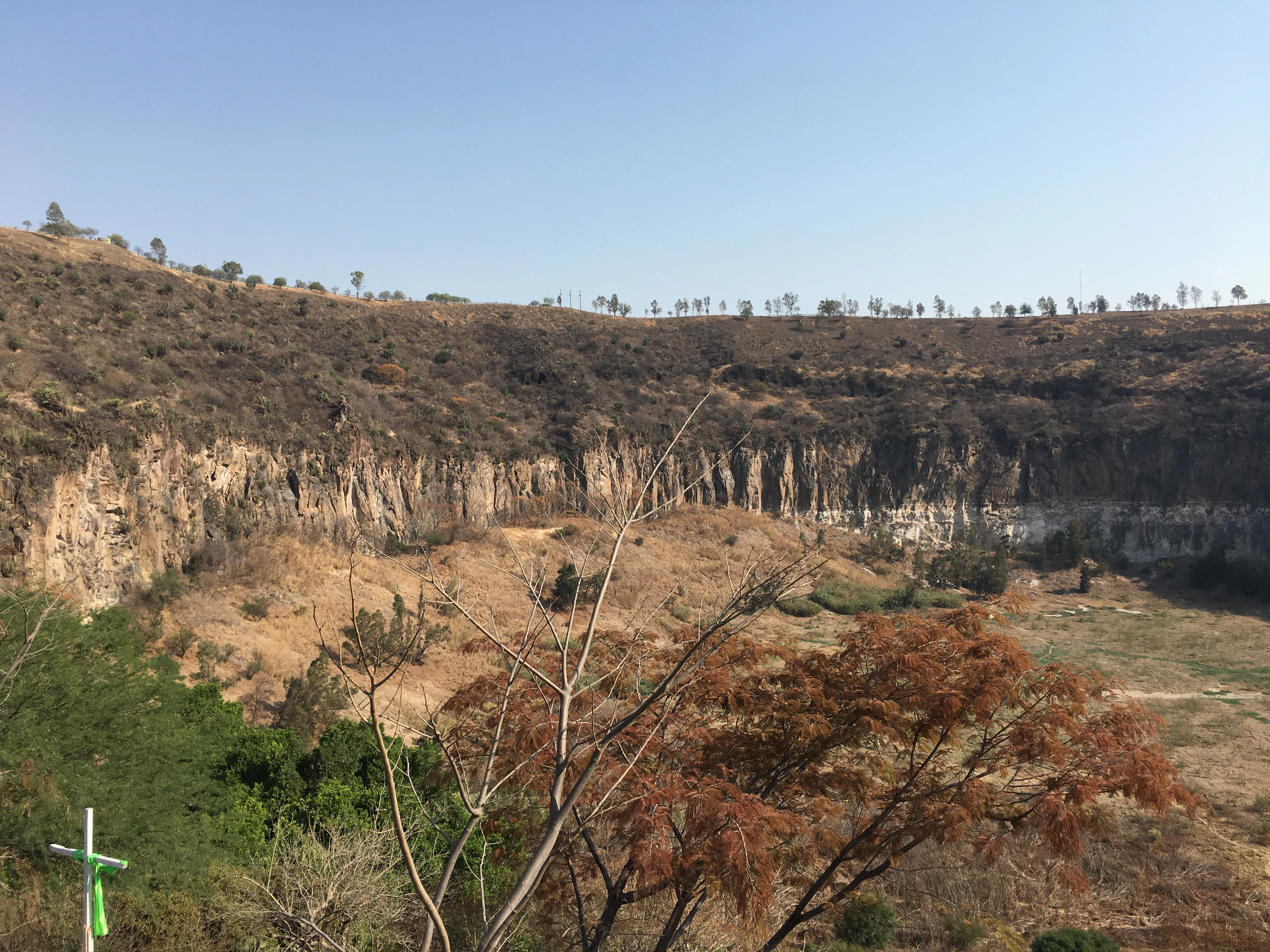
The landscape of Siete Luminarias is dominated by seven volcanic depressions scattered across the gently undulating terrain of the Bajío. Rather than towering cones, these are low-rimmed, bowl-shaped craters formed when rising magma encountered groundwater and exploded outward, producing broad blasts rather than vertical builds. The largest craters approach one kilometer in diameter, with flat, basin-like floors surrounded by steep inner walls.
The elevation of the group ranges roughly from 1,670 meters at Hoya la Alberca to 2,100 meters at Hoya de Flores, with the other craters occupying intermediate positions. The seven craters are: Hoya la Alberca (1,672 m), Hoya de Cíntora (1,703 m), Hoya de Flores or Hoya de Alvarez (2,100 m), Rincón de Parangueo (2,050 m), Hoya de San Nicolás de Parangueo (1,820 m), Hoya Blanca (1,819 m), and Hoya Solís (1,787 m). Surrounding the craters, the land slopes gently outward into farmland, orchards, and rural settlements of the Lerma basin.
The surrounding region belongs to the Mexican Plateau, but more specifically to the Bajío subregion, a relatively flat, fertile agricultural lowland bounded to the north by the Lerma River. This combination of broad, cultivated plain and abrupt volcanic openings gives Siete Luminarias a distinctive visual rhythm: long vistas of farmland interrupted by circular depressions that feel almost artificial against the otherwise flat terrain.
Siete Luminarias ecosystems, habitats, and plant life
Siete Luminarias lies within the Bajío dry forests ecoregion, a transitional zone where semi-arid conditions, seasonal rainfall, and agricultural transformation have shaped the vegetation cover. Around the volcanic craters, natural vegetation includes dry forest communities adapted to the relatively dry conditions of the central Mexican plateau, with mixtures of scrub, thorny shrubs, drought-tolerant trees, and seasonal herbaceous growth.
The varied microhabitats produced by the crater rims, walls, and floors create pockets of distinct vegetation, even in a largely human-altered agricultural landscape. Steep crater walls tend to retain native vegetation longer than surrounding flatlands, while flat floors that once held lakes have become exposed basins with their own soil and moisture patterns. The interplay between volcanic landforms and the dry-forest matrix gives the protected area an ecological mosaic that differs noticeably from the surrounding cropland.
Because the area is small and largely embedded within an agricultural matrix, its ecological value is tied closely to habitat continuity. The craters function as refugia for native dry-forest flora and associated fauna, against a backdrop of intensively cultivated land that has otherwise reduced natural vegetation cover across much of the Bajío.
Siete Luminarias wildlife and species highlights
Siete Luminarias occupies the Bajío dry forests ecoregion, which supports fauna typical of central Mexico's semi-arid plateau. The mosaic of dry forest, scrubland, and steep crater walls provides habitat for a range of resident and migratory birds, small mammals, reptiles, and insects characteristic of the region.
The volcanic craters historically added an extra habitat dimension by hosting crater lakes. Even after the lakes disappeared, their basins and surrounding vegetation continued to support wildlife associated with wetland margins, dry scrub, and transitional habitats. Over time, the fauna of the area has increasingly reflected the surrounding agricultural matrix, with species adapted to farmland and dry forest edges becoming prominent.
Because the protected area functions as an island of semi-natural habitat within a heavily cultivated region, its wildlife value lies less in charismatic megafauna and more in maintaining regional biodiversity reservoirs, supporting migratory and resident bird populations, and preserving ecological connectivity across the broader Bajío landscape.
Siete Luminarias conservation status and protection priorities
Siete Luminarias was declared a natural monument in 1997, a designation reserved for Mexican landscapes whose preservation is justified by their distinctive physical, geological, or aesthetic character. The roughly 89-square-kilometer protected zone was carved out around the seven craters to the south, west, and northwest of Valle de Santiago, ensuring that the principal volcanic features remain safeguarded even amid the surrounding agricultural pressures.
From a conservation perspective, the site's importance lies in its unusually dense concentration of maars. While individual volcanic craters exist elsewhere in the Michoacán–Guanajuato volcanic field, Siete Luminarias represents one of the most compact arrangements of this volcanic type in Mexico. Protecting the area helps preserve key reference points for understanding phreatomagmatic volcanism in central Mexico and for studying how maar landscapes evolve over time.
The natural monument designation also has a hydrological dimension. The drying of the historically lake-filled craters is widely linked to groundwater over-extraction in the Lerma basin, a pattern that has affected many wetland and lake systems across the Bajío. By placing the area under federal protection, authorities signaled that the craters and their associated hydrological systems warrant ongoing attention as part of broader regional conservation concerns.
Siete Luminarias cultural meaning and human context
The name "Siete Luminarias" translates roughly to "the Seven Luminaries," and the group's title reflects the way the craters have long been imagined as bright points, beacons, or luminous features within the surrounding agricultural landscape of Valle de Santiago. This poetic, almost celestial framing has shaped local identity, making the craters cultural icons as much as geological landforms.
Valle de Santiago and surrounding communities have historically treated the craters as part of their shared heritage, with stories, place names, and tourism traditions centered on the seven volcanic openings. The once lake-filled craters, in particular, inspired local legends and were visited as scenic landmarks before being drained by regional water demand. Their loss transformed them from living water features into memories, and the natural monument designation can be read partly as an effort to preserve what remains of that cultural identity in physical form.
Top sights and standout views in Siete Luminarias
Siete Luminarias stands out for the rare compactness of its seven maar volcanoes, all clustered within easy reach of one another around Valle de Santiago. Five named craters (Hoya la Alberca, Hoya de Cíntora, Hoya de Flores, Rincón de Parangueo, Hoya de San Nicolás, Hoya Blanca, and Hoya Solís) collectively define one of the most representative groupings of phreatomagmatic volcanism in the Michoacán–Guanajuato volcanic field.
Among the most notable individual features are Hoya la Alberca, often highlighted as the most visually striking crater, and Rincón de Parangueo, historically one of the most admired for its scenic lake. The elevation span from around 1,670 meters to 2,100 meters gives the group modest but distinct topographic variation, while the dry-forest setting on the Bajío agricultural plain emphasizes how abruptly the volcanic landforms interrupt the surrounding farmland.
Best time to visit Siete Luminarias
The climate of the Bajío is generally mild and semi-arid, with warm, relatively dry conditions much of the year. The cooler months from late autumn through early spring tend to be more comfortable for hiking exploration of the crater rims and surrounding landscape, when temperatures are lower and rainfall is minimal.
The rainy season, typically in summer, brings greener conditions and revived vegetation, which can enhance scenic interest but also makes some crater slopes more slippery and less accessible for casual visits. Given that crater lakes no longer exist, the visual character of the site depends largely on vegetation cover, atmospheric clarity, and the contrast of crater walls against the agricultural plain. Both dry and greener periods can offer rewarding views, with the trade-off between comfortable temperatures and lusher vegetation guiding the choice of season.