

Mori Atlas logo
Natural monumentSkalský rybník a Klokočínská olšina

A diverse wetland mosaic integrating fishponds, marshy terrain, and alder forest habitats

Skalský rybník a Klokočínská olšina Natural Monument: Mapped Protected Landscapes in Jihočeský kraj

Skalský rybník a Klokočínská olšina represents a significant natural monument within the Jihočeský kraj region of the Czech Republic. This protected area preserves a complex mosaic of open fishpond waters, reed-lined margins, and mature alder floodplain forests. By safeguarding these interconnected wetland and woodland habitats, the site maintains critical biological communities, including varied waterbird species and diverse pond-margin flora, within the broader South Bohemian pond country.

fishpondwetlandfloodplain forestalder woodlandwaterbirdsamphibians
A flat-style graphic illustration showing a cascading waterfall between rocky mountain cliffs surrounded by a lush forest and a foreground stream.

Skalský rybník a Klokočínská olšina

Natural monument

Park overview

Structured park overview, official facts, and landscape profile for Skalský rybník a Klokočínská olšina

Skalský rybník a Klokočínská olšina park facts, protected area profile, and essential visitor context

Review the core facts for Skalský rybník a Klokočínská olšina, including designation, size, terrain, visitor scale, habitats, and operating context in one park-focused overview.

About Skalský rybník a Klokočínská olšina

Skalský rybník a Klokočínská olšina is a compact protected area in the South Bohemian Region of the Czech Republic, tucked into the agricultural and pond-rich landscape between Protivín, Strakonice, and Písek. Designated as a přírodní památka, or natural monument, it occupies a portion of the broader Českobudějovická pánev, a lowland basin shaped by centuries of fishpond construction, water management, and traditional land use. Within this regional setting, the site stands out for preserving a particularly coherent set of wetland habitats in close proximity to one another.

The heart of the protected area is a still-water fishpond flanked by reed beds and other wetland vegetation along its banks. Beneath the dam, an older alder-dominated floodplain forest extends down into former wetland depressions, creating transitions from open water through marshy edges and into damp woodland. Nearby meadows add another ecological layer, and the whole complex is connected hydrologically, sharing the moist, nutrient-rich conditions that characterise the broader South Bohemian pond country.

The area's significance lies in both its habitat structure and its species composition. The pond and its draws support breeding populations of protected waterbirds, while the meadows, marshes, and alder stands provide food and shelter for a wider community of wetland-dependent species throughout the year. Amphibians use the shallow, vegetated water margins, and the damp forest floor offers habitat for plants that have become rare across much of the intensively farmed Czech landscape.

Administratively, the monument is managed by the AOPK regional office in České Budějovice, in line with the national system of small-scale protected sites. Its declaration reflects a long-running Czech tradition of conserving individual fishponds and their immediate surroundings as refuges for biodiversity, recognising that even modest areas can sustain notable ecological value when their characteristic processes are left intact.

Quick facts and research context for Skalský rybník a Klokočínská olšina

Skalský rybník a Klokočínská olšina is a přírodní památka, or natural monument, located in the Písek district of the South Bohemian Region, Czech Republic. It lies northeast of the village of Skály, between two well-used railway lines running from Protivín toward Strakonice and Písek, and forms part of the broader Českobudějovice basin landscape.

The site combines a fishpond, an adjoining alder-dominated floodplain forest along the dam foot, and associated wetlands and damp meadows. The protected area covers roughly 12.8 hectares, with an additional buffer zone extending the regulated surroundings beyond the core area. The monument was established in 1986 by the former Písek District National Committee and is administered by the AOPK regional office in České Budějovice.

Its principal conservation value rests on the joint ornithological and botanical interest of the site, encompassing protected waterbird species, characteristic wetland flora, and amphibian presence. The pond and adjoining forest together form a compact but ecologically varied refuge within a predominantly agricultural and forestry landscape.

Protection and recognition

Examine the documented terrestrial protection scope and administrative recognition details.

Skalský rybník a Klokočínská olšina Protection Status and Official Designation Facts

Skalský rybník a Klokočínská olšina maintains a documented terrestrial protection scope within its registered regional landscape. Structured facts outline administrative management parameters and official designation records for analytical terrain review.

Protection details

Protection scope
Terrestrial
Transboundary protection
No
Park context

Deeper park guide and search-rich context for Skalský rybník a Klokočínská olšina

Skalský rybník a Klokočínská olšina history, landscape, wildlife, and travel context

Explore Skalský rybník a Klokočínská olšina through its history, landscape character, ecosystems, wildlife, conservation priorities, cultural context, and seasonal travel timing in a structured park guide built for atlas discovery and search intent.

Why Skalský rybník a Klokočínská olšina stands out

The site is best known as a combined fishpond and alder floodplain forest natural monument in South Bohemia, valued for its wetland avifauna and its rich pond-margin flora. Three protected bird species are associated directly with the pond, while a vulnerable amphibian and several rare wading and passerine birds have been recorded in the surrounding meadows and wooded margins. The botanical interest centres on the wetland plants that thrive along the pond edges and in the marshy areas beneath the dam, including orchids, yellow flag iris, and a range of stream-side and mire species. Beyond the species inventory, the monument is notable for the way it preserves a tightly linked mosaic of open water, reeds, wet meadows, boggy patches, and damp alder woodland. This combination of habitats within a small footprint gives the site a conservation significance that is greater than its modest size might suggest, and places it within the wider tradition of Bohemian pond-country nature protection.
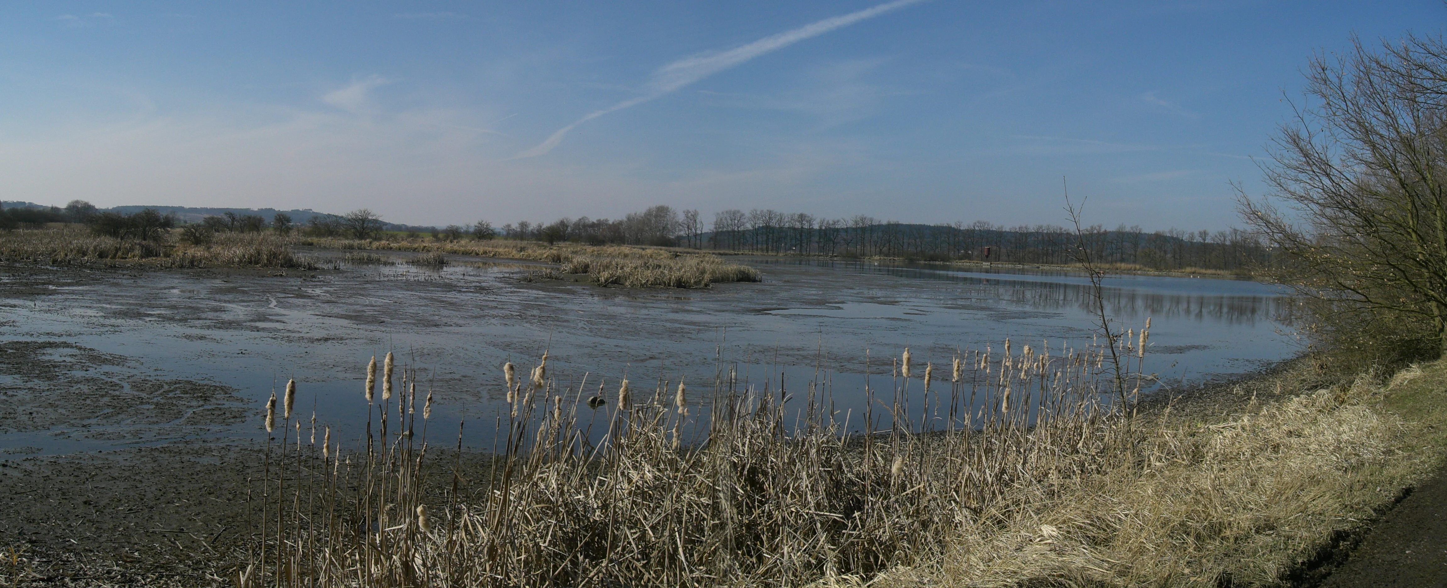
A wide, panoramic photograph of a shallow pond with marshy, reed-filled edges under a clear blue sky, set within a natural monument area.
Panoramic view of Skalský rybník, featuring its marshy shoreline and open water habitat.

Skalský rybník a Klokočínská olšina history and protected-area timeline

The natural monument was created by decree of the former District National Committee in Písek on 4 December 1985, taking legal effect on 1 February 1986. The protection order responded to the recognised botanical and zoological importance of the locality, and it brought the fishpond, its banks, and the wooded and marshy terrain beneath the dam under a single regulatory framework.

The site's name reflects its two most distinctive elements: the fishpond itself, which accounts for a significant share of the protected surface, and the Klokočín alder floodplain forest situated downslope of the dam. In spring 2008, the pond was partially drained as part of fisheries management, drawing attention to the vulnerability of wetland habitats and reinforcing the rationale for ongoing protection of the surrounding forest and marshland.

The longer historical context of the area lies in centuries of fishpond development across South Bohemia. Many of the region's ponds were originally established in the medieval and early modern periods to support fish farming and water management, and the landscape around Skalský rybník carries the imprint of that history. The protected area today represents the modern conservation effort that has grown up around this traditional pond-and-forest mosaic, recognising its value as a living refuge for native flora and fauna.

Skalský rybník a Klokočínská olšina landscape and geographic character

The landscape of the site is shaped by the broad, low-lying Českobudějovická pánev basin, in which gentle relief, heavy clay-rich soils, and a high water table produce the conditions typical of the South Bohemian pond country. From a geomorphological standpoint, the area falls within the Putimská pánev sub-basin and the more local Kestřanská pánev subunit, a flat landscape where water and wetland habitats dominate wherever drainage and water management allow.

Open water is a key visual and ecological element. The fishpond itself is bordered by reed belts and pond-margin vegetation that give way to damp soils and shallow marshes. Below the dam, the topography dips into a depression that hosts a fully developed floodplain forest, with mature alders and other moisture-loving broadleaf species standing over saturated ground and intermittent pools. Patches of wet meadow and degraded mire fringe the woodland, softening the transition between damper forest interiors and the more open agricultural land beyond the protected area boundary.

Human infrastructure is also part of the visible setting. The site lies between two well-used railway lines, the route from Plzeň to České Budějovice and the route from Zdice to Protivín, which means the pond has long coexisted with regular train traffic. This juxtaposition of active transport corridors and a quiet wetland refuge is a characteristic feature of many South Bohemian protected sites, where the traditional fishpond network survives within the modern working landscape.
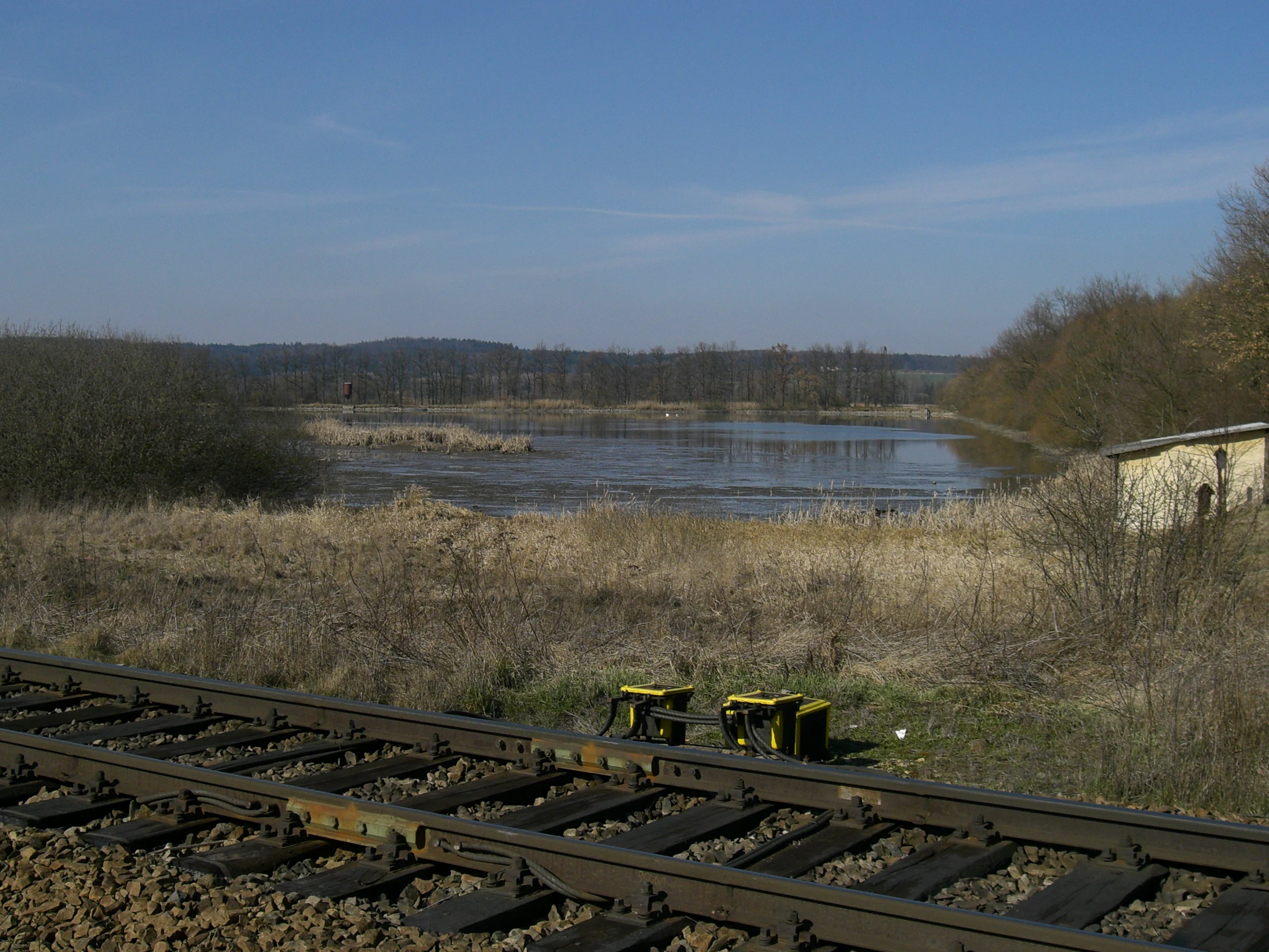
A view of a pond with calm water, dry marshy vegetation in the foreground, a small rustic building on the right, and railroad tracks in the immediate foreground.
View of Skalský rybník pond, showing the surrounding wetlands and adjacent railway tracks.

Skalský rybník a Klokočínská olšina ecosystems, habitats, and plant life

The ecological interest of Skalský rybník a Klokočínská olšina comes from the close mosaic of habitats it preserves within a small area. The pond, its marginal reeds, and the adjoining wet meadows provide open-water and emergent vegetation habitats, while the Klokočín alder forest and the marshy ground beneath the dam supply shaded, waterlogged woodland conditions. Together, these elements create a continuum from open water through marsh to damp forest, supporting a more diverse community of species than any single habitat on its own would.

The flora reflects both the open-water character of the pond and the wet woodland and mire character of the ground below the dam. Among the characteristic wetland plants recorded are tufted loosestrife, the May-flowering marsh orchid, water violet, yellow flag iris, shining meadow-rue, and the robust waterside sedge Carex riparia, alongside various other species typical of nutrient-rich but undisturbed pond margins. Beneath the alders, the moist, peaty soils support further examples of damp woodland flora, including a number of species that would be hard to maintain in drier, more disturbed surroundings.

Because the habitats intergrade, the site functions as an integrated wetland ecosystem rather than a collection of separate features. The pond fuels groundwater levels in the surrounding soils; the dam and the forest together regulate flooding and water storage; and the open and shaded zones provide different but complementary microclimates. This functional integration is a key reason the area was singled out for protection.

Skalský rybník a Klokočínská olšina wildlife and species highlights

Three protected bird species are documented as occurring on or around the fishpond itself: greylag goose, gadwall, and common tern. These species depend directly on the open water and the undisturbed pond margins, and their breeding presence is one of the principal indicators of the site's conservation value. Beyond the immediate pond area, additional protected species have been observed in the surrounding meadows and tree stands, including the critically endangered black-tailed godwit and the common redshank, as well as the Eurasian golden oriole in the more wooded parts of the locality.

In addition to its birdlife, the site is notable for amphibian presence. The fire-bellied toad has been recorded here, breeding in the shallow, vegetated margins and pools that connect the pond to the damper ground below. Historical records also note the osprey as a former visitor to the area, a reminder that large fish-hunting raptors have used these South Bohemian ponds as foraging habitat over the long term.

Taken together, the bird and amphibian record gives the site a recognisable wetland-avi-fauna profile that fits with the wider pattern of pond-based protected areas across South Bohemia. The combination of breeding waterfowl, passage waders, woodland passerines, and amphibians is characteristic of sites that successfully preserve both open water and the surrounding mosaic of reeds, meadows, and damp forest.

Skalský rybník a Klokočínská olšina conservation status and protection priorities

The declaration of Skalský rybník a Klokočínská olšina as a natural monument reflects the joint ornithological and botanical importance of the locality, which is recorded as the formal reason for protection. From a conservation perspective, the site matters because it safeguards several interconnected wetland habitats in a region where intensified agriculture and forestry have simplified the wider landscape. By protecting not only the pond itself but also its margins, the alder forest below the dam, and parts of the adjoining wet meadows and mires, the monument keeps ecological processes intact that would otherwise be lost.

The site is part of the national system of small-scale protected areas administered by the Agency for Nature Conservation and Landscape Protection of the Czech Republic, with day-to-day oversight handled by its regional office in České Budějovice. The classification as a přírodní památka means management focuses on maintaining the habitat conditions that underpin the protected species, rather than on large-scale restoration. In practice, this means regulating activities around the pond, controlling invasive influences on the banks and forest edge, and coordinating with fish-farming operations where necessary, as illustrated by the partial drainage of the pond in 2008.

Its wider conservation value lies in its contribution to the South Bohemian pond network, one of the most important traditional fishpond systems in Central Europe. Together with neighbouring protected sites, the monument helps maintain the regional population of wetland plants, breeding waterbirds, and amphibians, and it preserves the natural infrastructure that allows these communities to persist in a working agricultural landscape.

Skalský rybník a Klokočínská olšina cultural meaning and human context

The cultural context of Skalský rybník a Klokočínská olšina is rooted in the centuries-old tradition of fishpond cultivation that defines the South Bohemian landscape. Many of the region's ponds were created during the medieval and early modern periods to support the farming of carp and other fish, and the surrounding woodland, meadows, and marshland developed in close interaction with that economy. The protected fishpond here sits within that long-established cultural landscape, even though its current role is now primarily focused on biodiversity conservation.

The interaction between human infrastructure and natural heritage is also visible in the immediate surroundings. Two major railway lines pass through the area, a reminder that traditional landscapes in Bohemia have been progressively overlaid with modern transport networks, and the protected area represents a deliberate choice to maintain pockets of ecological value alongside those developments. The alder floodplain forest, beyond its nature value, also reflects older patterns of woodland management in the wetter parts of the basin, where alder has long been favoured for its tolerance of saturated soils.

Top sights and standout views in Skalský rybník a Klokočínská olšina

Skalský rybník a Klokočínská olšina stands out as a compact but ecologically rich natural monument in the South Bohemian pond country. Its key qualities include the combination of an active fishpond with a mature alder floodplain forest and adjoining wet meadows, the documented presence of three protected bird species directly at the pond, and a broader community of wading birds, golden oriole, and amphibians that use the surrounding habitats. Botanical interest is equally strong, with a mix of characteristic pond-margin wetland plants and damp-forest flora coexisting within the same protected footprint.

The site also illustrates how small protected areas can punch above their weight by preserving multiple connected habitats rather than a single feature. In a landscape dominated by fishponds, fields, and managed forest, this monument demonstrates how even a modest area of integrated wetland, marsh, and alder woodland can continue to support a diverse flora and fauna, while still sitting comfortably within a broader cultural and economic landscape shaped by centuries of human activity.

Best time to visit Skalský rybník a Klokočínská olšina

The site, like other South Bohemian pond-and-forest natural monuments, varies in character across the year and is at its most rewarding when its ecological features are most active. Late spring and early summer are typically the strongest seasons for botanical interest and for observing breeding waterbirds and amphibians around the pond margins, when wetland plants are flowering and the reed belts are in full use by nesting birds.

In late summer and early autumn, the surrounding meadows and the alder forest beneath the dam take on a more visible character, with mature vegetation offering rich habitat for a wider community of insects, birds, and small mammals. Late autumn and winter bring a quieter phase, when large numbers of waterfowl may gather on open water if conditions allow, and the bare structure of the alder floodplain forest becomes easier to appreciate. Visitors planning to see the locality should bear in mind that it is a small conservation site, intended primarily for low-impact enjoyment of nature rather than active recreation.

Monthly climate preview

Long term monthly averages for temperature and precipitation spanning representative regional coordinates

Skalský rybník a Klokočínská olšina Climate Normals and Annual Temperature Rhythm

Representative baseline coordinates trace measured monthly temperature ranges and precipitation rates across the protected terrain. Access the full twelve month profile to inspect complete seasonal norms and detailed meteorological patterns.
Annual mean8 °C
-3 °C19 °C
Jan-3°
Feb-1°
Mar
Apr
May13°
Jun17°
Jul19°
Aug19°
Sep13°
Oct
Nov
Dec-2°
Warmest month
July

18.8 °C

Coolest month
January

-2.8 °C

Wettest month
July

3 mm/day

Driest month
February

1.1 mm/day

Park location guide

Geography guide, regional context, and park location map for Skalský rybník a Klokočínská olšina

Skalský rybník a Klokočínská olšina park geography, regions, and map view in Czechia

Understand where Skalský rybník a Klokočínská olšina sits in Czechia through a broader geographic reading of the surrounding landscape, nearby location context, and its mapped position within the national park landscape.

How Skalský rybník a Klokočínská olšina fits into Czechia

Czech Republic is a landlocked Central European country with a population of approximately 10.9 million people. The nation was established as an independent state on January 1, 1993, following the dissolution of Czechoslovakia. Its capital and largest city is Prague, with other major urban centers including Brno, Ostrava, Plzeň, and Liberec.

Wider geography shaping Skalský rybník a Klokočínská olšina in Czechia

The Czech Republic is a landlocked country in Central Europe. It is bordered by Germany to the west, Austria to the south, Poland to the northeast, and Slovakia to the southeast. The landscape is predominantly hilly, with the territory covering 78,871 square kilometers.

Map view of Skalský rybník a Klokočínská olšina

Use this park location map to pinpoint Skalský rybník a Klokočínská olšina in Czechia, understand its exact geographic position, and read its mapped placement within the surrounding landscape more clearly.

Pigeon | © OpenStreetMap contributors

Location context for Skalský rybník a Klokočínská olšina

Jihočeský kraj

Visual exploration of South Bohemian wetlands, alder floodplain forests, and pond habitats.

Skalský rybník a Klokočínská olšina Photos and Protected Area Landscape Scenery

Visual documentation of Skalský rybník a Klokočínská olšina captures the distinct interplay of open fishpond waters, reedy margins, and saturated alder floodplain woodlands. Photographic records reveal the protected terrain and interconnected wetland habitats that define this South Bohemian natural monument.

A wide, panoramic photograph of a shallow pond with marshy, reed-filled edges under a clear blue sky, set within a natural monument area.

A small wooden sign with the coat of arms of the Czech Republic mounted on a post in front of a pond and marshy landscape.

A view of a pond with calm water, dry marshy vegetation in the foreground, a small rustic building on the right, and railroad tracks in the immediate foreground.

Park atlas

Compare nearby South Bohemian wetland reserves and connected natural monuments

Parks near Skalský rybník a Klokočínská olšina and surrounding protected areas

Discover other protected areas located near Skalský rybník a Klokočínská olšina across the South Bohemian basin. This selection supports regional comparison by connecting similar wetland habitats, fishpond ecosystems, and floodplain forests.
A watercolor painting showing a panoramic view of a marshy wetland area with sparse bare trees, grassy mounds, and rolling hills in the background.
Natural monumentJihočeský kraj
About 6.1 km away#1 closest

Northwest

Ražický rybník Natural Monument and Protected Wetland Geography in South Bohemia

Protected pond ecosystems and riparian terrain maps

Ražický rybník is a protected natural monument located in the Písek District of the Czech Republic, encompassing a shallow fishpond and surrounding meadows. This site serves as an essential breeding ground for waterbirds and provides a detailed look at the wetland mosaic characteristic of the Otava river lowlands. The area highlights the intersection of long-standing conservation efforts and habitat restoration through its diverse aquatic microhabitats.

Area
0.291 km²
Established
1986
IUCN
IV
Relief
Lowland
Natural monumentJihočeský kraj
About 11 km away#2 closest

Northwest

Velký Potočný: Protected Natural Monument and Wetland Geography in the South Bohemian Region

An essential migratory node and rare plant refuge in the Czech landscape.

Velký Potočný represents a unique intersection of traditional fishpond management and modern biodiversity conservation in Jihočeský kraj. This natural monument supports exceptional shoreline vegetation, including rare species like Cyperus fuscus, and serves as a critical breeding and stopover ground for diverse waterbirds. Its shallow basin geography and hydrologic connection to the Otava River make it a vital point of interest for understanding the ecological function of South Bohemia's inland wetland network.

Area
0.39 km²
Established
1986
IUCN
IV
Relief
Lowland
A wide watercolor illustration showing a pale landscape with a stream, rocky banks, distant hills, and pink and green grass in the foreground.
Natural monumentJihočeský kraj
About 17 km away#3 closest

Northwest

Michovka Natural Monument: Protected Limestone Landscapes in the South Bohemian Region

A diverse protected area in the Písek District of the Czech Republic.

Located on the outskirts of Brloh u Drhovle, Michovka encompasses a distinctive mix of fishponds, limestone-rich rocky slopes, and rare short-sedge vegetation. This compact protected area provides a vital habitat for endangered wildlife and represents an important segment of the South Bohemian natural terrain.

Area
0.025 km²
Established
1985
IUCN
IV
Relief
Lowland
Natural monumentJihočeský kraj
About 21 km away#4 closest

South

Velký Karasín Natural Monument: Mapped Wetland Geography and Protected Landscape Context

A protected wetland sanctuary in the South Bohemian Region of the Czech Republic.

Discover the geographic character of Velký Karasín, a compact natural monument featuring an eutrophic fishpond and fringing reed beds. This protected area serves as an essential site for waterbirds and endangered dragonfly populations, offering a clear example of wetland preservation amidst the gently undulating terrain of the České Budějovice District.

Area
0.108 km²
Established
1991
IUCN
IV
Relief
Lowland
Natural monumentJihočeský kraj
About 21 km away#5 closest

North

V Obouch Natural Monument: Geographic Profile of the Lomnice River Valley

Protected riparian corridors and riverine terrain in Jihočeský kraj

Explore the unique geomorphology of V Obouch, a protected river segment in the Czech Republic. This site provides a detailed cross-section of alder floodplain forests, boulder rapids, and canyon-like terrain that defines the ecological character of the South Bohemian river network.

Area
0.051 km²
Established
1986
IUCN
IV
Relief
Upland
A watercolor painting of soft green rolling hills and small clusters of pine trees against a light sunset sky.
Natural monumentJihočeský kraj
About 21 km away#6 closest

West

Ryšovy Natural Monument and Botanical Protected Area in Jihočeský kraj

Exploring limestone woodland terrain and rare floral habitats

Ryšovy is a notable natural monument in the Czech Republic, defined by its characteristic limestone bedrock and the resulting diverse herb layer. This protected area creates a significant botanical stronghold within the wider landscape of the Jihočeský kraj, featuring a mosaic of woodland patches and sun-exposed clearings that support protected orchids and other rare thermophilous plant species.

Area
0.35 km²
Established
1990
IUCN
IV
Relief
Upland
A horizontal watercolor illustration depicting rolling green hills in the background, a line of trees in the midground, and a grassy meadow with small white flowers in the foreground.
Natural monumentPrachatice District
About 22 km away#7 closest

South

Mastnice Natural Monument: Protected Stream Valley and Wetland Habitat in Prachatice District

Ecologically significant wet meadow and valley geography in the Czech Republic

Mastnice is a protected natural monument situated within the Prachatice District, characterized by its waterlogged meadows and damp woodland margins along a stream valley. This site serves as a key botanical reserve, offering a rare look at valley wetland ecosystems that provide essential habitats for seasonal flora and diverse local species in the South Bohemian region.

Area
0.011 km²
Established
1988
IUCN
IV
Relief
Upland
A minimalist watercolor illustration depicting a soft, light-toned landscape with a row of trees on the right and distant, blurred hills in the background.
Natural monumentJihočeský kraj
About 23 km away#8 closest

North

Rukávečská obora: Natural Monument and Protected Beech Forest in Jihočeský kraj

A historic protected landscape in the Písek Highlands

Located in the Czech Republic, Rukávečská obora represents a significant natural monument defined by its 225-year-old beech stands. This site provides an essential look at the geological and botanical history of the Písek Highlands, serving as a key protected area for local invertebrate and bird species within the Vltava river valley watershed.

Area
0.067 km²
Established
1929
IUCN
V
Relief
Upland

Common questions about visiting, size, designation, and location context for Skalský rybník a Klokočínská olšina

Skalský rybník a Klokočínská olšina FAQs for park facts, access, geography, and protected area context

Find quick answers about Skalský rybník a Klokočínská olšina, including protected-area facts, park geography, trail and visitor context, and how the park fits into its surrounding country and regional landscape.
MoriAtlas Explorer

Continue Your Protected Areas Search Across the Global Atlas

Deepen your exploration by continuing the structured search for national parks and protected areas worldwide. Utilize the comprehensive filtering capabilities to compare different conservation landscapes and refine your understanding of global park geography. Discover more about the distribution and characteristics of protected natural areas.

Global natural geography