
Mori Atlas logo
Natural monumentSlaná louka u Újezdce

Examining the saline meadows and dry calcareous grasslands within this Natura 2000 protected landscape

Slaná louka u Újezdce Natural Monument: A Protected Lowland Mosaic in Central Bohemia

(Přírodní památka Slaná louka u Újezdce)

Slaná louka u Újezdce functions as a critical natural monument in the Central Bohemia Region, safeguarding a unique mosaic of saline meadows, semi-natural dry grasslands, and scrub facies. This protected area represents an essential fragment of lowland terrain, where specific soil chemistry sustains a rare habitat cluster that has largely vanished from the surrounding agricultural landscape. By mapping these micro-habitats, the site illustrates the role of compact Natura 2000 localities in preserving ecological diversity.

saline grasslanddry grasslandcalcareous substrateNatura 2000natural monumentlowland habitat
An artistic, stylized vector illustration of a dramatic mountain valley with a waterfall flowing down cliffs into a river winding through a forest meadow.

Slaná louka u Újezdce

Natural monument

Park overview

Structured park overview, official facts, and landscape profile for Slaná louka u Újezdce

Slaná louka u Újezdce park facts, protected area profile, and essential visitor context

Review the core facts for Slaná louka u Újezdce, including designation, size, terrain, visitor scale, habitats, and operating context in one park-focused overview.

About Slaná louka u Újezdce

Slaná louka u Újezdce sits in a quietly remarkable corner of the Central Bohemian lowlands, just east of the village of Újezdec in the Mělník District. Although it covers only around 1.38 hectares, the site punches well above its weight ecologically because it captures a habitat combination that has become extraordinarily rare across the modern Czech countryside: saline meadows interspersed with semi-natural dry grasslands and shrubby transitions, all resting on a calcareous base.

The reserve was formally declared a přírodní památka (natural monument) on 19 April 2013 by the Regional Authority of the Central Bohemian Region. Its designation extends the Czech Natura 2000 network into one of its smallest but most specialised entries, anchoring a fragment of halophytic and steppe-like vegetation within an otherwise intensively used agricultural landscape. At roughly 168 metres above sea level, the site lies firmly in the lowland zone, where such relict habitats tend to be especially vulnerable to plowing, drainage, fertilizer input, and scrub encroachment in the absence of grazing or mowing.

What makes the site ecologically interesting is the way very different microhabitats sit side by side. Salt-influenced soils support specialised halophytic plant communities, while adjacent dry grassland patches reflect warmer, thinner soils over the calcareous substrate. The transition zones, described as facies of shrubs, add structural diversity and provide habitat edges for insects, small mammals, and birds. Together these elements form a compact but coherent representation of habitats that, elsewhere in the region, have been almost entirely lost.

For conservation planning, Slaná louka u Újezdce illustrates the value of small protected patches within the Natura 2000 framework. Rather than protecting a vast sweep of landscape, the site's significance rests on preserving a precise ecological signature, the right soil chemistry, the right hydrological balance, and the right disturbance regime, in a setting where surrounding land uses would otherwise erase it. The site's modest size also makes it a clean, clearly bounded example of how targeted Czech habitat protection can maintain specialised biodiversity even in heavily modified lowlands.

Quick facts and research context for Slaná louka u Újezdce

Slaná louka u Újezdce is a Czech natural monument (přírodní památka) registered under code 5780 in the Mělník District of the Central Bohemian Region. It was declared on 19 April 2013 by the Regional Authority of the Central Bohemian Region (Krajský úřad Středočeského kraje). The site lies on the eastern edge of the village of Újezdec, at an elevation of around 168 metres, and covers approximately 1.38 hectares of lowland terrain. It protects a Natura 2000 locality of European importance defined by saline meadows, semi-natural dry grasslands, and scrub facies on calcareous substrate.

Protection and recognition

Documented terrestrial protection scope and official Natura 2000 records

Slaná louka u Újezdce Protection Status and International Recognition Data

Terrestrial protection status records for Slaná louka u Újezdce detail the documented management scope and official designation sources. Verified Natura 2000 entries establish the recognized administrative boundary data for this protected area.
Park context

Deeper park guide and search-rich context for Slaná louka u Újezdce

Slaná louka u Újezdce history, landscape, wildlife, and travel context

Explore Slaná louka u Újezdce through its history, landscape character, ecosystems, wildlife, conservation priorities, cultural context, and seasonal travel timing in a structured park guide built for atlas discovery and search intent.

Why Slaná louka u Újezdce stands out

Slaná louka u Újezdce is best known for protecting a small but ecologically valuable complex of saline meadows and semi-natural dry grasslands on calcareous substrate, classified as a Natura 2000 site of European importance. The unusual coexistence of salt-tolerant meadow vegetation, steppe-like dry grassland, and patches of scrub within a compact lowland fragment is what defines the site's conservation identity. The habitat mosaic reflects the broader significance of saline and dry grassland habitats in Central Europe, where surviving examples have become fragmented relics of once more extensive semi-natural landscapes. The site's inclusion in the Natura 2000 network underscores its role in safeguarding habitat types that are scarce across the Czech Republic.
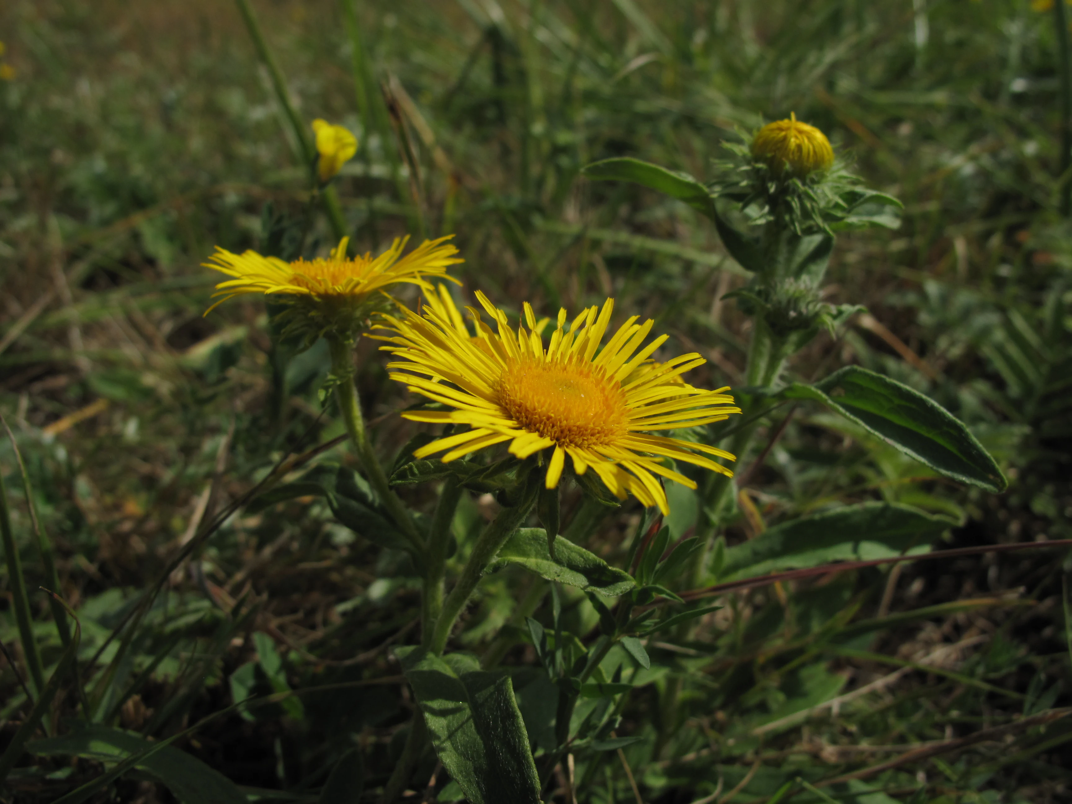
A close-up view of bright yellow daisy-like flowers growing in a grassy field.
Yellow wildflowers blooming in the saline meadows of Slaná louka u Újezdce.

Slaná louka u Újezdce history and protected-area timeline

The formal history of Slaná louka u Újezdce is short and recent. It was first designated as a protected site on 19 April 2013, when it was declared a přírodní památka, or natural monument, by the Regional Authority of the Central Bohemian Region (Krajský úřad Středočeského kraje). The site was registered under code 5780 in the Czech system of specially protected areas.

The establishment of the monument was driven by the conservation value of the parcel as a Natura 2000 locality of European importance, reflecting the broader Czech and European push to formalise protection for small but ecologically distinctive habitat fragments. Prior to its declaration, the land held the same saline meadow and dry grassland character that motivated protection, but lacked formal safeguards against land use changes. The 2013 designation effectively legalised and stabilised the conservation status of a habitat type that has steadily retreated across the Czech lowlands.

Slaná louka u Újezdce landscape and geographic character

The landscape of Slaná louka u Újezdce is a lowland scene, gently elevated at about 168 metres above sea level on the eastern outskirts of the village of Újezdec. Topographically, the site is subdued, with no dramatic relief; instead, its character comes from the contrast between open grassy ground, low shrubby transitions, and the subtle influence of soil chemistry on the vegetation above it.

The defining physical feature is the calcareous substrate, which conditions the dry grassland patches and helps create the warm, thin-soil conditions that support steppe-like plant communities. Salt-influenced soils add a second physical signature, producing localised saline meadow conditions that are unusual this far inland in Bohemia. Shrub facies occupy transitional zones within the site, breaking up the open ground and adding vertical structure to what would otherwise be a uniform grassland.

Together, these features make the landscape a small but unusually textured lowland mosaic: saline flats, dry calcareous turf, and shrubby edges interleaved within a parcel only marginally larger than a hectare and a half.
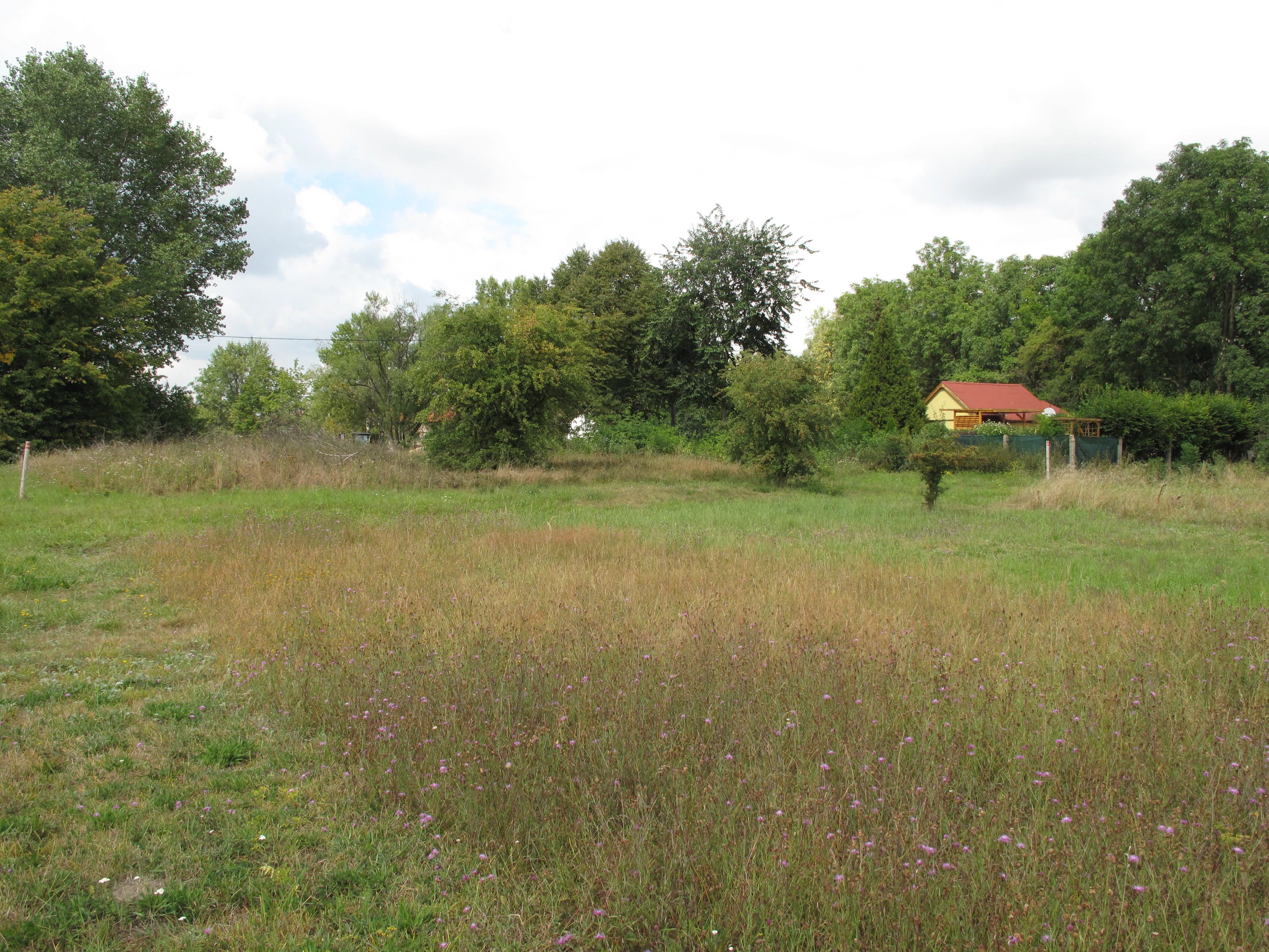
A meadow with patches of tall dry grass and wildflowers under a cloudy sky, with trees and a small building with a red roof in the background.
A view of the saline meadow and dry grassland landscape at Slaná louka u Újezdce.

Slaná louka u Újezdce ecosystems, habitats, and plant life

Ecologically, Slaná louka u Újezdce is defined by a tightly compressed mosaic of habitats that are individually rare and ecologically specialised. The site's core consists of saline meadows, a habitat type tied to elevated salt concentrations in the soil that support halophytic plant communities adapted to osmotic stress. These communities are scarce in the Czech Republic, partly because historical land improvement has eliminated or diluted many of the natural saline conditions on which they depend.

Adjacent to the saline meadow areas, the monument protects semi-natural dry grasslands on calcareous substrate. These dry grasslands characteristically harbour a rich mix of herbaceous species, including stress-tolerant flowering plants that thrive on thin, well-drained, mineral-rich soils. The calcareous base contributes to higher pH and lower water retention, favouring species that would not persist on more acidic or heavily fertilised soils.

The third element of the ecological mosaic is the scrub facies: patches of shrubs that break up the open grassland and create ecotones between meadow and dry grassland habitats. These transitions are ecologically valuable because they support different suites of insects, pollinators, and small vertebrates than either open habitat does on its own, and they increase overall structural diversity across the small site.
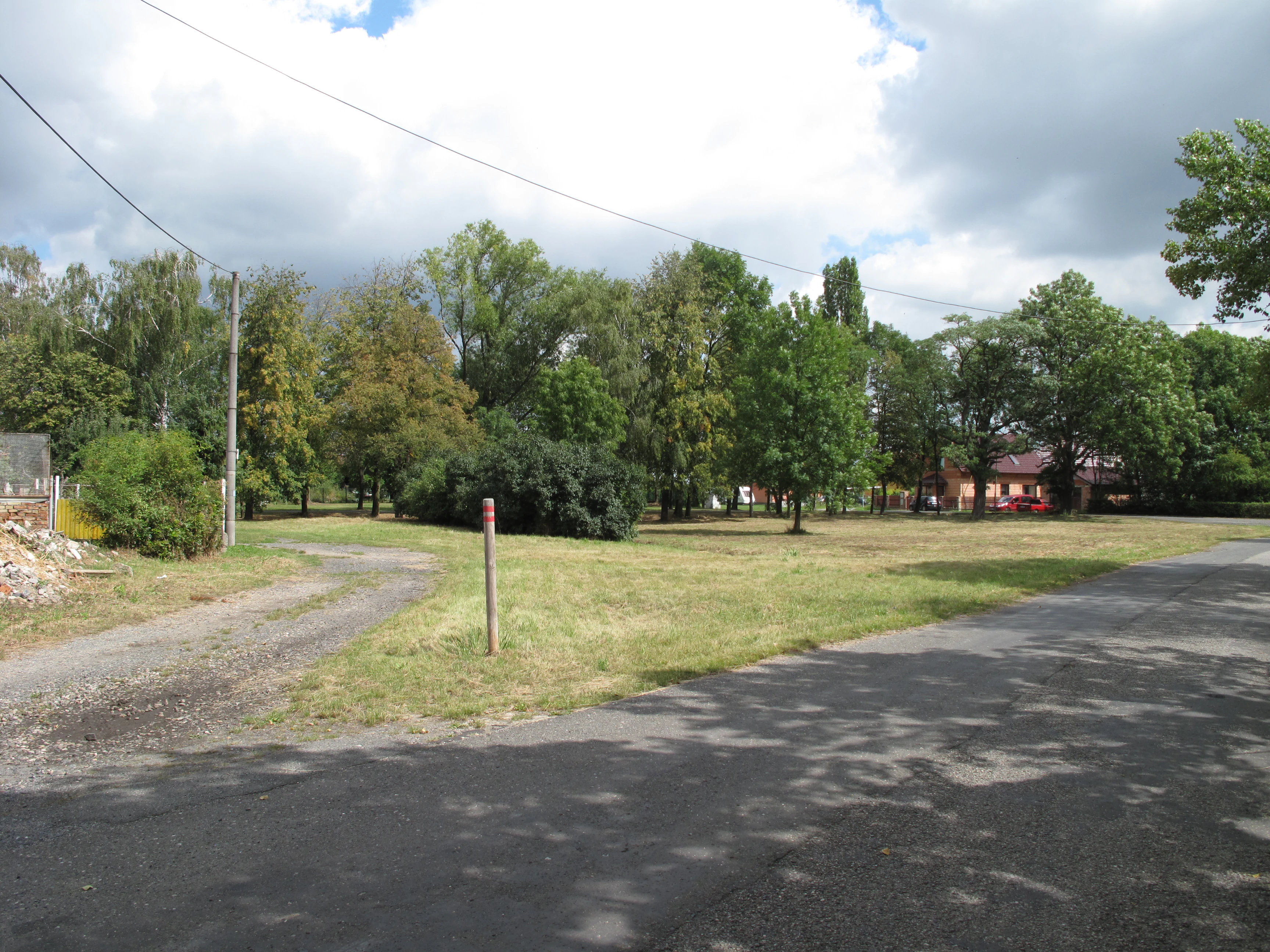
A grassy field with scattered trees and a paved road leading into the scene, under a cloudy sky.
A view of the landscape at Slaná louka u Újezdce natural monument.

Slaná louka u Újezdce wildlife and species highlights

Given its small size and habitat composition, Slaná louka u Újezdce is best understood as an insect- and plant-rich site rather than a large-mammal reserve. The dry calcareous grasslands and saline meadows provide habitat for a high diversity of invertebrates, including pollinators such as bees, butterflies, and other insects that depend on flowering herbs in semi-natural grasslands. Such grasslands often host disproportionately rich invertebrate assemblages compared with improved agricultural land, even when their overall area is small.

Shrubby transitions add nesting and shelter opportunities for small passerine birds and micromammals that use the grassland-shrub interface. The combination of open ground and scattered shrub cover is particularly valuable for species that feed in the open but require nearby cover for refuge and breeding.

While the source material does not list specific vertebrate species, the ecological logic of the site, saline meadows plus dry grassland plus scrub edges, strongly suggests an invertebrate-rich, grassland-dependent fauna typical of lowland Central European Natura 2000 localities. The monument's value is therefore primarily about preserving the habitat structure that supports such communities rather than showcasing any single flagship species.

Slaná louka u Újezdce conservation status and protection priorities

Slaná louka u Újezdce is primarily a habitat-protection site rather than a species-protection site. Its conservation significance lies in safeguarding a Natura 2000 locality that combines saline meadows, semi-natural dry grasslands, and scrub facies on calcareous substrate, all of which are habitat types prioritised at the European level because of their ongoing decline across much of the continent.

The declaration of the site in 2013 by the Regional Authority of the Central Bohemian Region reflects the broader effort, embedded in both Czech nature conservation law and the European Union's Habitats Directive, to maintain functioning examples of scarce habitat types even where only very small fragments survive. In the intensely farmed lowlands around Mělník, such fragments are vulnerable to nutrient enrichment, ploughing, drainage alterations, and successional overgrowth without appropriate management.

By protecting a precise parcel at the village edge, the monument locks in a stable framework for ongoing management, whether through mowing, controlled grazing, or scrub control, that is required to keep the open grassland character from being lost. The site's inclusion in the Natura 2000 network also gives it a stronger cross-border conservation context, linking its fate to the wider European effort to conserve calcareous and halophytic grassland habitats.

Slaná louka u Újezdce cultural meaning and human context

The cultural context of Slaná louka u Újezdce is closely tied to the rural character of the village of Újezdec and to the broader agricultural history of the Mělník lowlands. Such saline and dry grassland habitats in central Bohemia are typically remnants of former extensive land use, often associated with grazing, haymaking, or mineral-rich substrate conditions linked to historical settlement patterns.

The site's location on the village edge, described in local imagery as the land at the náves (village green) area, signals its integration into the everyday rural setting of Újezdec rather than its separation as a remote wilderness. This proximity highlights how biodiversity conservation in the Czech lowlands often depends on protective designations for small parcels that survive within, or adjacent to, traditional villages.

Top sights and standout views in Slaná louka u Újezdce

Slaná louka u Újezdce stands out for combining three ecologically distinctive habitat types, saline meadows, semi-natural dry calcareous grasslands, and scrub facies, into a single compact Natura 2000 locality of only about 1.38 hectares. It is a textbook example of small-scale, habitat-targeted conservation in the Czech Natura 2000 network, illustrating how micro-reserves can preserve European-important habitat signatures that have almost disappeared from the surrounding lowland farmland.

Its easy integration into the immediate landscape of the village of Újezdec also makes it a clear, accessible case study in lowland grassland protection, demonstrating how biological diversity in central Bohemia can be maintained even right at the interface of a traditional rural settlement.

Best time to visit Slaná louka u Újezdce

Slaná louka u Újezdce is a lowland site whose interest is strongly seasonal. Late spring and summer are generally the most rewarding periods, when the dry calcareous and saline grasslands come into flower and the diversity of herbs in semi-natural grassland habitats is at its peak. These are also the months when pollinators and other invertebrates that depend on the flowering vegetation are most active.

Outside the growing season, the site becomes visually quieter, with reduced flowering display and lower invertebrate activity, although the open structure of the grassland remains visible. Visitors interested specifically in the botanical character of saline and dry grassland habitats will find late spring through early summer the most instructive window, while those interested in the broader landscape context can visit at any time of year given the mild lowland climate of the Mělník area.


Monthly climate preview

Long-term representative point measurements tracking monthly temperature and precipitation patterns

Slaná louka u Újezdce Climate Normals and Annual Temperature Rhythm

Slaná louka u Újezdce records a measured annual temperature span from sub-zero winter minimums to warm summer highs alongside consistent daily precipitation normals. Reviewing the complete twelve-month climatology dataset clarifies the broader environmental rhythm sampled across the representative coordinate.
Annual mean9 °C
-2 °C20 °C
Jan-2°
Feb-1°
Mar
Apr
May14°
Jun18°
Jul20°
Aug19°
Sep14°
Oct
Nov
Dec-1°
Warmest month
July

19.8 °C

Coolest month
January

-2.3 °C

Wettest month
July

2.4 mm/day

Driest month
February

1 mm/day

Park location guide

Geography guide, regional context, and park location map for Slaná louka u Újezdce

Slaná louka u Újezdce park geography, regions, and map view in Czechia

Understand where Slaná louka u Újezdce sits in Czechia through a broader geographic reading of the surrounding landscape, nearby location context, and its mapped position within the national park landscape.

How Slaná louka u Újezdce fits into Czechia

Czech Republic is a landlocked Central European country with a population of approximately 10.9 million people. The nation was established as an independent state on January 1, 1993, following the dissolution of Czechoslovakia. Its capital and largest city is Prague, with other major urban centers including Brno, Ostrava, Plzeň, and Liberec.

Wider geography shaping Slaná louka u Újezdce in Czechia

The Czech Republic is a landlocked country in Central Europe. It is bordered by Germany to the west, Austria to the south, Poland to the northeast, and Slovakia to the southeast. The landscape is predominantly hilly, with the territory covering 78,871 square kilometers.

Map view of Slaná louka u Újezdce

Use this park location map to pinpoint Slaná louka u Újezdce in Czechia, understand its exact geographic position, and read its mapped placement within the surrounding landscape more clearly.

Pigeon | © OpenStreetMap contributors

Location context for Slaná louka u Újezdce

Central Bohemia Region
Recorded earthquake history

Explore Historical Earthquake Records Associated with Slaná louka u Újezdce

Review the full catalogue of documented seismic activity and epicentre records linked to the Slaná louka u Újezdce area. MoriAtlas provides this historical data to assist with geographic exploration of the region and to offer clear insight into local recorded earthquake events.

Slaná louka u Újezdce Earthquake History

Catalogued events

7 events

Strongest magnitude

Magnitude 3.7

Most recent event

Mar 29, 1991

This history includes earthquakes recorded inside the park or within 50 km of its borders

Photographic reference for lowland saline meadows, dry grasslands, and protected habitat mosaics

Visual Exploration of Slaná louka u Újezdce Photos and Landscape Scenery

Visual documentation of Slaná louka u Újezdce reveals the distinctive terrain, halophytic vegetation, and calcareous grassland patches that define its protected area character. Detailed photographic coverage provides clear insight into the rare habitat mosaic preserved within this central Bohemian lowland landscape.

A close-up view of bright yellow daisy-like flowers growing in a grassy field.

A close-up high-angle view of a patch of dry meadow grass interspersed with small yellow wildflowers.

A meadow with patches of tall dry grass and wildflowers under a cloudy sky, with trees and a small building with a red roof in the background.

A grassy field with scattered trees and a paved road leading into the scene, under a cloudy sky.

Park atlas

Compare surrounding lowland habitats, dry grasslands, and protected reserves in central Bohemia.

Other Parks and Protected Areas Near Slaná louka u Újezdce for Regional Comparison

Browse other protected areas near Slaná louka u Újezdce to examine similar lowland habitats and rare grassland ecosystems across the surrounding region. Extending the geographic comparison reveals broader conservation patterns within the Czech protected landscape network.
Natural monumentStředočeský kraj
5.4 km away#1 closest

West

Veltrusy Natural Monument: Protected Woodland and Historic Park Geography in Středočeský kraj

English-style designed landscapes and floodplain ecological habitats.

Veltrusy Natural Monument is a protected area located on the right bank of the Vltava River, defined by its horseshoe-shaped layout and mosaic of oak-beech woodlands. The site represents a rare intersection of cultural heritage and nature conservation, preserving veteran trees that support significant invertebrate populations. Its geography consists of gently undulating floodplain terrain shaped by the Mlýnský potok, historic avenues, and managed meadows.

Area
2.555 km²
Established
2013
IUCN
III
Relief
Lowland
Natural monumentStředočeský kraj
About 13 km away#2 closest

North

Vehlovické opuky Natural Monument: Geological Mapping and Historical Mining Context

Protected paleontological and mining heritage in the Czech Republic

Vehlovické opuky stands as a compact but rich natural monument in the Středočeský kraj region. This protected area showcases the geological legacy of the Bohemian Cretaceous Basin, preserving fossilized remains within yellowish opuka beds and demonstrating historical underground extraction techniques that now support local bat populations.

Area
0.009 km²
Established
2002
IUCN
III
Relief
Lowland
A pale watercolor painting showing a river winding through green hills and gentle slopes.
Protected landscapePrague
About 15 km away#3 closest

South

Přírodní park Drahaň-Troja: Protected Landscape Geography and Mapped Terrain Analysis

Deep stream valleys and rocky steppe habitats in Prague

Přírodní park Drahaň-Troja represents a vital protected landscape characterized by its pronounced relief, including the Bohnické, Čimické, and Drahanské valleys. This area reveals the geological history of the Prague region through its exposed shales and volcanic rhyolite veins. Discover how this continuous green corridor integrates rare steppe ecosystems with the metropolitan urban edge.

Area
5.79 km²
Established
1990
Relief
Upland
Climate
Temperate
Natural monumentPrague
About 17 km away#4 closest

South

Velká skála Natural Monument: Geological Protected Area within the Prague Plateau

A landmark siliceous rock outcrop in the Troja district

Velká skála offers a concentrated look at the geological heritage of central Bohemia. As a designated natural monument, the site protects a rare siliceous rock outcrop that contrasts with the rolling terrain of the surrounding Prague Plateau, serving as a vital reference for regional geomorphology.

Area
0.018 km²
Established
1968
IUCN
III
Relief
Upland
A watercolor illustration depicting a soft, panoramic landscape of gentle, rolling green hills, scattered trees, and grassland areas with a muted color palette.
Nature reserveStředočeský kraj
About 18 km away#5 closest

Northeast

Na oboře Nature Reserve in Středočeský kraj: A Detailed Geographic Atlas Overview

Protected loess slopes and rare steppe ecosystems.

Na oboře comprises a series of south-facing slopes in the Středočeský kraj region, serving as a sanctuary for heat-loving flora and critically endangered insect species. The reserve features a rare geological intersection of wind-deposited loess and sandstone bedrock, forming a warm, mineral-rich landscape that remains a vital, mapped study area for steppe-like grassland conservation in the Czech Republic.

Area
0.034 km²
Established
2001
IUCN
IV
Relief
Upland
A horizontal watercolor illustration showing a soft, dreamy landscape with rolling green hills, light purple and yellow tones, a winding path or stream, and a lone bare tree in the foreground.
Protected landscapePraha
About 20 km away#6 closest

South

Přírodní park Šárka-Lysolaje: Protected Landscape Mapping and Geographic Identity in Praha

A dense mosaic of stream valleys and protected natural monuments near the heart of Praha

Examine the detailed geography of Přírodní park Šárka-Lysolaje, an extensive protected landscape in Praha that functions as a critical green corridor. Its terrain, defined by deeply incised stream valleys and steep forested slopes, hosts a unique concentration of smaller nature reserves and monuments, creating a coherent ecological framework directly adjacent to the urban metropolitan environment.

Area
10.05 km²
Established
1990
Climate
Temperate
Scope
Terrestrial
Natural monumentPrague
20 km away#7 closest

South

Vizerka Natural Monument: Mapped Protected Landscapes and Rocky Terrain in Prague

A rare xerothermic steppe refuge on the edge of the Šárka Valley

Vizerka represents a compact yet significant natural monument located on the rocky slopes of the Šárecké údolí in Prague. Featuring exposed Proterozoic shale and shallow soils, this protected site serves as a vital island of thermophilic grasslands and shrubby terrain. It offers a fascinating look at relict warm-loving habitats and rare species survival within the dense geographical context of a European capital city.

Area
0.031 km²
Established
1988
IUCN
IV
Relief
Upland
Natural monumentLitoměřice District
22 km away#8 closest

Northwest

Vrbka Natural Monument: Exploring Protected Limestone Habitats and Bohemian Lowland Geography

A rare botanical reserve in the Litoměřice District of the Czech Republic

Vrbka Natural Monument protects a significant 15.5-hectare expanse of warm limestone slopes and dry meadows. This geographic landmark serves as an essential repository for rare orchid species and diverse insect populations, functioning as a representative habitat patch within the intensively cultivated landscapes of the surrounding region.

Area
0.155 km²
Established
2013
IUCN
IV
Relief
Upland

Common questions about visiting, size, designation, and location context for Slaná louka u Újezdce

Slaná louka u Újezdce FAQs for park facts, access, geography, and protected area context

Find quick answers about Slaná louka u Újezdce, including protected-area facts, park geography, trail and visitor context, and how the park fits into its surrounding country and regional landscape.
MoriAtlas Explorer

Continue Your Protected Areas Search Across the Global Atlas

Deepen your exploration by continuing the structured search for national parks and protected areas worldwide. Utilize the comprehensive filtering capabilities to compare different conservation landscapes and refine your understanding of global park geography. Discover more about the distribution and characteristics of protected natural areas.

Global natural geography