

Mori Atlas logo
Natural monumentSlanisko u Škrle

A study in inland halophytic vegetation, mineralised soil chemistry, and delicate floodplain terrain

Slanisko u Škrle Natural Monument and Rare Saline Habitat in the Ústecký Kraj Region

Located in the Chomutov district of the Ústecký Kraj, Slanisko u Škrle stands as a significant protected natural monument safeguarding a rare inland saline meadow. This small but ecologically dense site features a mosaic of xerothermic grasslands, sulphate-rich soils, and floodplain vegetation along the Chomutovka river. Its geography offers a rare glimpse into specialised plant communities that thrive in mineralised landscapes far removed from coastal environments.

halophytic habitatinland saline meadownatural monumenthalophyte conservationdry grasslandxerothermic flora

Slanisko u Škrle

Natural monument

Park overview

Structured park overview, official facts, and landscape profile for Slanisko u Škrle

Slanisko u Škrle park facts, protected area profile, and essential visitor context

Review the core facts for Slanisko u Škrle, including designation, size, terrain, visitor scale, habitats, and operating context in one park-focused overview.

About Slanisko u Škrle

Slanisko u Škrle is a small but ecologically specialised protected area in the northwestern part of the Czech Republic, in the Chomutov district of the Ústecký Region. It lies on the western edge of the village of Škrle, near the settlement of Bílence, in the valley of the Chomutovka river. Although it is modest in size, the natural monument is considered a regionally and nationally important locality because it preserves a rare inland saline habitat (in Czech, "slanisko") that supports a surprisingly species-rich community of plants adapted to salty and dry conditions.

The reserve sits within the Mostecká pánev, or Most Basin, a geologically distinctive part of north Bohemia shaped by Tertiary and Quaternary sediments. Within that basin, the area belongs to the smaller Chomutovsko-teplická pánev unit and the Jirkovská pánev subunit. The slope faces gently to the south above the floodplain of the Chomutovka, a setting that combines warm exposure with mineralised, salt-influenced soils to create conditions that are normally found only along sea coasts.

Ecologically, the site is valued because it brings together three distinct habitat types on a very small footprint: saline grassland, dry xerothermic herbaceous vegetation, and damp flood-meadow communities along the river. That habitat diversity is the reason the area was declared a natural monument in 2002 and why it was later incorporated into a larger European site of importance, recognising its contribution to the conservation of threatened habitats across the European Union.

For visitors and researchers alike, Slanisko u Škrle illustrates how localised geochemical conditions, in this case sulphate-rich groundwater feeding magnesium-rich salts into the soil, can create an ecological island within an otherwise typical Central European agricultural and forest landscape. It is a useful example of how small protected areas can carry weight far beyond their physical extent.

Quick facts and research context for Slanisko u Škrle

Slanisko u Škrle is a Czech natural monument (přírodní památka) in the Chomutov district of the Ústecký Region, covering roughly 3.4 hectares along the Chomutovka river valley near the village of Škrle. The site is classified as an IUCN Category IV area, designated primarily for the protection of specific species and habitats.

It lies at around 250 to 265 metres above sea level, in a warm lowland climate zone with annual rainfall of roughly 550 to 700 millimetres. The reserve forms part of a larger European site of importance, and its value centres on inland saline soils, halophytic vegetation, and rare botanical populations.

Protection and recognition

Review verified terrestrial protection measures and Natura 2000 listings.

Slanisko u Škrle Protection Status and Documented International Recognition

Terrestrial conservation records for Slanisko u Škrle outline documented protection status and official Natura 2000 framework assignments. Structured recognition sources compile verified administrative boundaries to support analytical park geography research.

International recognition

Protection details

Protection scope
Terrestrial
Transboundary protection
No
Park context

Deeper park guide and search-rich context for Slanisko u Škrle

Slanisko u Škrle history, landscape, wildlife, and travel context

Explore Slanisko u Škrle through its history, landscape character, ecosystems, wildlife, conservation priorities, cultural context, and seasonal travel timing in a structured park guide built for atlas discovery and search intent.

Why Slanisko u Škrle stands out

Slanisko u Škrle is best known for its exceptional concentration of halophytic, or salt-tolerant, plant species in an inland Bohemian setting. The reserve preserves a small, mineralised grassland on a slope above the Chomutovka river where the chemistry of the soil supports a flora more typical of coastal salt meadows. The star species is the sea plantain, a critically endangered plant in the Czech Republic that finds a refuge here along with associated halophytes such as toothed melilot, slender hare's-ear, salt spurrey, and British inula. The combination of saline soils, drought-tolerant grassland plants, and adjacent flood-meadow vegetation makes the site a textbook example of how unusual geology can produce a tightly clustered, ecologically precious habitat far from the sea.
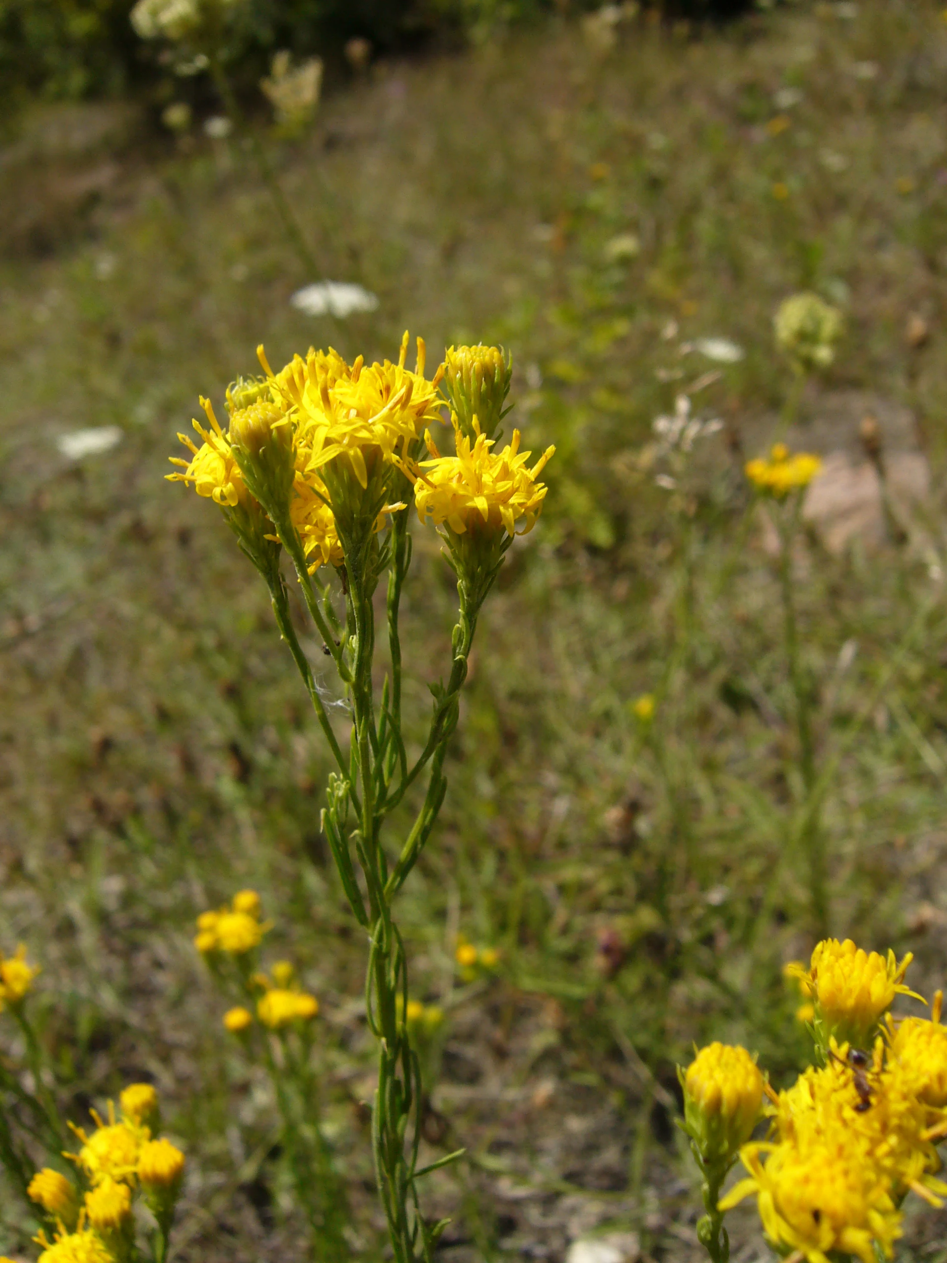
Aster linosyris at Slanisko u Skrle
Goldilocks aster (Aster linosyris) in bloom

Slanisko u Škrle history and protected-area timeline

Before the twentieth century the Slanisko u Škrle area functioned primarily as pasture land. That grazing use persisted, at least occasionally, until the 1970s. Even during those decades of intermittent pasturing, the dynamics of the landscape were shifting: parts of the site were being colonised by self-sown Scots pines, while the remaining dry, narrow-leaved grasslands began to be overrun by tall, competitive grasses, especially bush grass.

The salt content of the soil slowed that spread to some extent, but the trend was clearly toward woody and coarse-grass encroachment. In the floodplain of the Chomutovka, common reed similarly expanded its footprint. The decision to designate the area as a protected natural monument, taken by the District Office in Chomutov on 28 May 2002, marked a turning point: management based on a formal care plan was introduced to suppress reed, bush grass, and woody encroachment, and active restoration efforts began to preserve the open saline and meadow habitats.

A particular conservation initiative involved the deliberate relocation of two rare species, marsh cnidium and black-spiked sedge, into the protected site to reinforce its populations. In 2009 the area was further recognised by being included within a European site of importance, extending its conservation framework beyond national borders and reinforcing its long-term protection status.

Slanisko u Škrle landscape and geographic character

The landscape of Slanisko u Škrle is shaped by its position within the Most Basin of north Bohemia. The regional landforms are defined by Tertiary, especially lower to middle Miocene, sediments of sand, gravel, and clay, later overlaid by sandy alluvial loams deposited in the floodplain of the Chomutovka river.

Within that broader basin the protected area itself occupies a small, gentle slope that tilts to the south above the river. The incline is modest rather than dramatic, but its combination of warm exposure and mineralised soils is what allows the unusual vegetation to thrive here. Soil chemistry is dictated by sulphate minerals dissolved in groundwater, with magnesium sulphate as the dominant salt, creating the saline character implied by the site's name.

The terrain around the reserve belongs to the Jirkovská pánev subunit, a lowland section of the Chomutovsko-teplická pánev. From a wider perspective, the area is a transition between the flat, often industrial lowlands of the Most Basin and the more rolling country toward the mountains further north, but at the local scale the scene is intimate: a sunny slope, a narrow floodplain, and a mosaic of dry grassland, saline meadow, and reedy wetland that fits within just a few hectares.
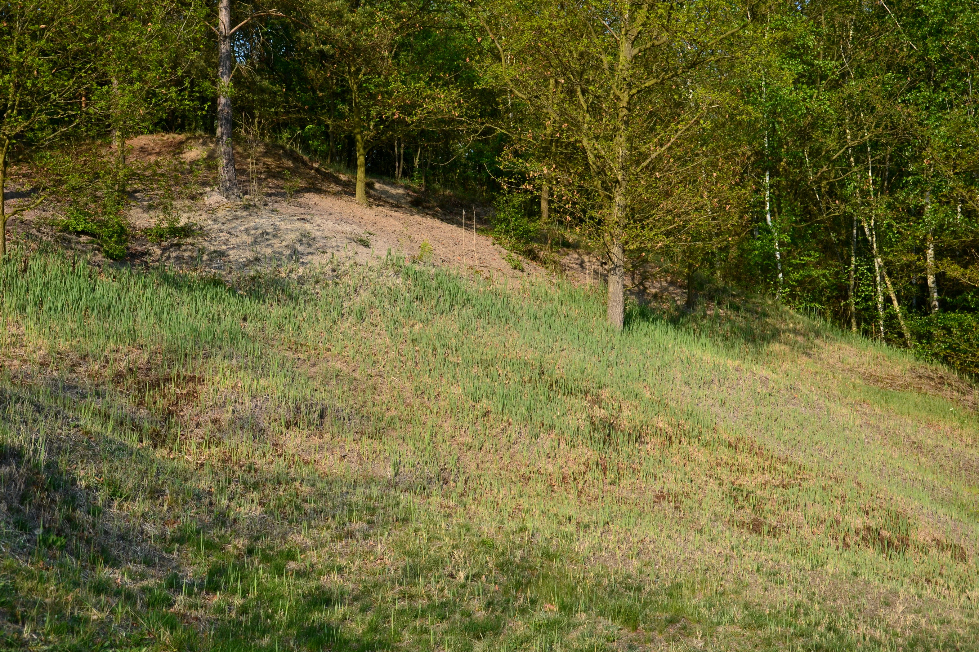
Slanisko u Skrle landscape
Detail view of the hillside at Slanisko u Skrle nature monument

Slanisko u Škrle ecosystems, habitats, and plant life

Ecologically, Slanisko u Škrle is defined by the unusual inland occurrence of a halophytic community, a plant assemblage adapted to saline soil conditions. The local soils are sufficiently mineralised that they host species more typical of coastal salt meadows. Sea plantain is the dominant halophyte here, accompanied by toothed melilot, slender hare's-ear, salt spurrey, and a small centaury species, all of which thrive despite being far from any marine environment.

Alongside the saline flora, a markedly xerothermic, or drought- and heat-loving, vegetation has developed on the drier parts of the slope. Golden-aster and Danish astragalus are characteristic components, lending the grassland a distinctly steppe-like character in the warmest months. The contrast between that dry, species-rich turf and the more lush, moist vegetation of the slope and river margin is one of the defining features of the site.

A third ecological dimension is provided by the floodplain grasslands along the Chomutovka, where rare meadow species such as marsh cnidium, Cambridge milk-parsley, saw-wort, shiny meadow-rue, and a subspecies of red bartsia grow among reed beds. The combination of saline, dry, and wet habitats within such a compact area gives the reserve an unusually complete ecological profile for its size, and explains why it has attracted long-term botanical research, including a 2018 revision of halophytic plant occurrences across the Chomutov area.

Slanisko u Skrle nature monument
View of the eastern section of the Slanisko u Skrle nature monument

Slanisko u Škrle wildlife and species highlights

Although the reserve is primarily recognised for its botanical interest, it also supports a meaningful faunal community tied to its mosaic of open habitats. The mix of saline meadow, dry grassland, and reedy floodplain produces a varied structure that benefits several bird species of conservation concern.

Among the most notable birds are the Eurasian wryneck, a small woodpecker-like species that depends on open, insect-rich countryside; the barred warbler, a scarce songbird associated with warm, shrubby slopes; and the corn bunting, a farmland-edge species that has declined across much of Europe and retains important populations in open lowland settings like this one. Their presence underlines the value of even very small open-habitat reserves for sustaining regional bird diversity.

The wetland fringes add to that value by providing habitat for insects and other invertebrates associated with reed vegetation and mineral-rich soils, which in turn sustain the broader food web supporting these birds. While the site's wildlife profile is modest compared with larger national parks, its combination of rare plants, specialist birds, and habitat complexity gives Slanisko u Škrle a clear role in regional biodiversity conservation.

Slanisko u Škrle conservation status and protection priorities

Slanisko u Škrle carries conservation significance that extends well beyond its small geographical footprint. It is officially recognised as a natural monument under Czech law, which gives it legal protection against damaging land-use changes and obliges authorities to manage it according to an approved care plan. At the European level, the site is part of a larger European site of importance, integrating it into the Natura 2000 network that safeguards priority habitats across the continent.

The conservation focus of the reserve centres on the protection and recovery of halophytic vegetation, one of the rarest habitat types in the Czech Republic. Active management has been used to curb the spread of common reed in the floodplain, limit the encroachment of bush grass and woody species on the open slope, and prevent pine regeneration from closing the grassland. These interventions aim to maintain the open conditions on which the saline and xerothermic flora depend.

A second conservation priority is the safeguarding of populations of critically endangered plant species, especially sea plantain, and the maintenance of carefully introduced populations of other rare halophytic species such as marsh cnidium and black-spiked sedge. The 2018 halophyte revision across the Chomutov area reaffirmed the site's importance as a confirmed locality for several of these species. In this way, Slanisko u Škrle functions as both a refuge and a recovery site for some of the country's most threatened plant communities, demonstrating the disproportionate ecological value that very small, intensively managed reserves can hold.

Slanisko u Škrle cultural meaning and human context

The cultural context of Slanisko u Škrle is closely tied to traditional rural land use in the Chomutov region of north Bohemia. Until the mid twentieth century the locality was regularly used as pasture, and intermittent grazing continued into the 1970s. That long history of low-intensity grazing is one of the reasons the open character of the grassland persisted, inadvertently keeping the saline flora viable before formal protection arrived.

The village of Škrle and the nearby municipality of Bílence belong to a rural landscape that has long balanced agriculture, small-scale settlement, and, in modern times, the broader industrial footprint of the Most Basin. The natural monument sits within this matrix as a reminder of the ecological heritage that survived despite those pressures.

There is no documented indigenous or unusually distinctive cultural tradition tied specifically to the saline meadow itself. Instead, the site's cultural value lies in its role as a surviving fragment of the region's traditional open countryside, now repurposed as a conservation landscape for rare botanical and ecological values.

Top sights and standout views in Slanisko u Škrle

The standout feature of Slanisko u Škrle is the rare inland occurrence of a true saline plant community, with sea plantain and other halophytes growing on sulphate-rich soils in what is otherwise an inland Bohemian agricultural setting. Equally striking is the diversity of complementary habitats packed into a very small area, including dry xerothermic grassland, saline meadow, and floodplain vegetation along the Chomutovka river.

Best time to visit Slanisko u Škrle

Slanisko u Škrle is most rewarding to experience during late spring and summer, when the dry, warm-loving grasses and the halophytic flora are at their most visible. Sunny weather best reveals the contrast between the saline slope and the river-margin meadows, and the relatively low elevation and warm local climate mean that the flowering season tends to peak earlier in the year than in more upland parts of the Czech Republic.

In early spring the site is accessible and pleasant for short visits focused on landscape and habitat context, while the flood-meadow plants along the Chomutovka remain easier to observe before reed growth reaches its full summer density. As the year cools, the open character of the slope continues to provide good views of the habitat mosaic, though the botanical highlights of the saline community are more subdued outside the late spring and summer growing season.

Monthly climate preview

Track representative monthly temperature averages and precipitation totals for Slanisko u Škrle

Slanisko u Škrle Climate Normals and Long-Term Temperature Patterns

Representative coordinate measurements record long-term temperature ranges and daily precipitation values across twelve distinct monthly intervals for Slanisko u Škrle. Examining the full climate profile reveals detailed monthly averages that support rigorous geographic analysis of local environmental normals.
Annual mean8 °C
-3 °C19 °C
Jan-3°
Feb-1°
Mar
Apr
May13°
Jun17°
Jul19°
Aug18°
Sep13°
Oct
Nov
Dec-2°
Warmest month
July

18.7 °C

Coolest month
January

-2.6 °C

Wettest month
July

2.5 mm/day

Driest month
February

1.1 mm/day

Park location guide

Geography guide, regional context, and park location map for Slanisko u Škrle

Slanisko u Škrle park geography, regions, and map view in Czechia

Understand where Slanisko u Škrle sits in Czechia through a broader geographic reading of the surrounding landscape, nearby location context, and its mapped position within the national park landscape.

How Slanisko u Škrle fits into Czechia

Czech Republic is a landlocked Central European country with a population of approximately 10.9 million people. The nation was established as an independent state on January 1, 1993, following the dissolution of Czechoslovakia. Its capital and largest city is Prague, with other major urban centers including Brno, Ostrava, Plzeň, and Liberec.

Wider geography shaping Slanisko u Škrle in Czechia

The Czech Republic is a landlocked country in Central Europe. It is bordered by Germany to the west, Austria to the south, Poland to the northeast, and Slovakia to the southeast. The landscape is predominantly hilly, with the territory covering 78,871 square kilometers.

Map view of Slanisko u Škrle

Use this park location map to pinpoint Slanisko u Škrle in Czechia, understand its exact geographic position, and read its mapped placement within the surrounding landscape more clearly.

Pigeon | © OpenStreetMap contributors

Location context for Slanisko u Škrle

Ústecký kraj
Recorded earthquake history

Explore Historical Earthquake Records Associated with Slanisko u Škrle

Deepen your geographic understanding of Slanisko u Škrle by reviewing the documented history of seismic events in the nearby Most Basin. MoriAtlas provides this transparent catalogue for comparative analysis of regional seismic activity and epicentre distribution.

Slanisko u Škrle Earthquake History

Catalogued events

9 events

Strongest magnitude

Magnitude 3.8

Most recent event

Nov 15, 2004

This history includes earthquakes recorded inside the park or within 50 km of its borders

Visual exploration of inland saline habitats, rare flora, and river valley terrain

Slanisko u Škrle Photos and Protected Landscape Scenery

Visual records reveal the unique salt-tolerant plant communities and mineralised grassland terrain defining Slanisko u Škrle. Photographic documentation provides critical insight into the rare inland saline habitats and fragile floodplain ecosystems preserved across the reserve.

Aster linosyris at Slanisko u Skrle

British elecampane

Slanisko u Skrle landscape

Slanisko u Skrle nature monument

Park atlas

Compare nearby regional reserves and connected protected landscapes

Other Parks and Protected Areas Near Slanisko u Škrle

Browse other parks and protected areas near Slanisko u Škrle to examine regional geography and related natural habitats. Regional park comparison reveals broader ecological patterns across the Chomutov subregion and surrounding Bohemian terrain.
Nature reserveÚstecký kraj
About 8.1 km away#1 closest

West

Pražská pole Nature Reserve: An Atlas of Wetland Recovery in Ústecký kraj

Protected wetland landscapes in the Czech Most Basin

Pražská pole is a remarkable nature reserve in the Ústecký kraj region, serving as a testament to natural recovery following deep brown coal mining. The site features a network of ten flooded subsidence depressions that host diverse aquatic communities, including specialized amphibians and dragonflies. This protected area offers significant value for understanding how industrial legacies transform into functional, high biodiversity wetland ecosystems within the Czech landscape.

Area
1.14 km²
Established
2024
IUCN
IV
Water
Major water bodies
Natural monumentÚstecký kraj
12 km away#2 closest

East

Velká Volavka Natural Monument: Protected Landscape and Regional Botanical Geography

A rare saline plant refuge in the Ústecký kraj foothills.

Velká Volavka is a specialized natural monument protecting an inland salt-steppe community at the foot of the Ranské středohoří range. This botanical sanctuary provides critical habitat for endangered halophilous species, showcasing a unique intersection of geological seepage and rare flora within the Czech Republic landscape.

Area
0.006 km²
Established
2000
IUCN
IV
Relief
Upland
Natural monumentÚstecký kraj
About 17 km away#3 closest

Southwest

Sluňáky Natural Monument: Geological Mapping and Protected Landscape Context

A preserved quartzite boulder field in the Ústecký kraj

Sluňáky represents a vital geological record within the Czech Republic, encompassing a distinctive group of silicified sandstone boulders. This natural monument serves as an important protected territory that illustrates the intersection of Tertiary geology and historical industrial extraction. The surrounding terrain reflects the complex volcanic and sedimentary history of the Doupovské hory foothills.

Area
0.032 km²
Established
1966
IUCN
III
Relief
Upland
Nature reserveÚstecký kraj
About 18 km away#4 closest

Southwest

Vinařský rybník Nature Reserve: Geographic Map and Protected Wetland Landscape

Lowland basin geography and habitat boundaries in Ústecký kraj.

Vinařský rybník represents a vital nature reserve and lowland wetland in the Ústecký kraj region, showcasing a distinct landscape of shallow ponds, reedbeds, and alluvial sediments. This site forms a key component of the regional avian habitat network, offering a concentrated look at the geological and hydrological features of the Žatecká pánev basin through detailed landscape mapping.

Area
0.151 km²
Established
1990
IUCN
IV
Relief
Upland
Natural monumentÚstí nad Labem Region
22 km away#5 closest

South

Soběchlebské terasy Natural Monument: Geography and Protected Ravine Landscapes

Regional protected area analysis in the Ústí nad Labem Region

Soběchlebské terasy is a specialized natural monument situated in the Louny district, protecting a deep, narrow stream valley carved by the Černocký stream. The landscape is characterized by its steep, terraced woodland slopes, providing an essential thermophilic environment for rare orchids and oak-dominated forest fragments within the northwestern Czech Republic.

Area
0.026 km²
Established
2011
IUCN
IV
Relief
Upland
Natural monumentÚstecký kraj
About 23 km away#6 closest

West

Na loučkách II Natural Monument: Mapped Geography and Protected Upland Landscapes

Conservation areas in the Ore Mountains of the Ústecký kraj

Na loučkách II encompasses a substantial upland territory in the Czech Republic, characterized by a mix of peatland basins, heathland, and montane meadow mosaics. This natural monument serves as an essential ecological link within the Ore Mountains, protecting diverse highland terrain and supporting sensitive habitats in the Ústecký kraj administrative region.

Area
6.623 km²
Established
2013
IUCN
IV
Relief
Highland
Protected landscapeStředočeský kraj
About 24 km away#7 closest

Southeast

Přírodní park Džbán: Geography and Protected Landscape Analysis of the Džbán Ridge

Forested highland and hydrological center of Středočeský kraj

Přírodní park Džbán encompasses a significant Cretaceous plateau and mixed-woodland system that functions as a triple watershed for three major river basins. The park preserves a rich mosaic of thermophilic plants and woodland fauna while maintaining the characteristic opuka geological features that define the vernacular architecture of this central Bohemian region.

Area
416 km²
Established
1994
Relief
Upland
Climate
Temperate
Nature reserveÚstecký kraj
About 24 km away#8 closest

Northwest

Prameniště Chomutovky: Nature Reserve Boundaries and Regional Landscape Context

Protected peatland ecosystems in the Czech Republic

Prameniště Chomutovky serves as a pivotal protected area in the Ore Mountains, characterized by its deep peat deposits and open bog-pine mosaics. This documentation of the reserve includes its role as a black grouse habitat, its connection to the Novodomské rašeliniště network, and the distinct geomorphology that shapes its montane environment.

Area
18.82 km²
Established
2012
IUCN
IV
Relief
Mountain

Common questions about visiting, size, designation, and location context for Slanisko u Škrle

Slanisko u Škrle FAQs for park facts, access, geography, and protected area context

Find quick answers about Slanisko u Škrle, including protected-area facts, park geography, trail and visitor context, and how the park fits into its surrounding country and regional landscape.
MoriAtlas Explorer

Continue Your Protected Areas Search Across the Global Atlas

Deepen your exploration by continuing the structured search for national parks and protected areas worldwide. Utilize the comprehensive filtering capabilities to compare different conservation landscapes and refine your understanding of global park geography. Discover more about the distribution and characteristics of protected natural areas.

Global natural geography