
Mori Atlas logo
Natural monumentSmutný

A preserved 2.5 kilometer stretch of the Smutná River showing undisturbed lowland stream dynamics

Smutný Natural Monument: Analyzing the Meandering Fluvial Geography and Protected Riparian Terrain

Smutný Natural Monument represents a critical protected corridor in the Jihočeský kraj region of the Czech Republic, where the Smutná River maintains a rare, freely meandering path. The protected landscape stretches from the Chobot pond dam to the Na Maděrovce bridge, encompassing a riparian zone defined by shifting gravel bars and natural hydraulic processes. By shielding this crystalline basement valley from agricultural straightening, the monument preserves a functional example of historical Bohemian stream behavior and vital freshwater habitats.

natural monumentmeandering riverlowland streamriparian habitatwetland plantsotter habitat
A graphic illustration showing a river winding through a valley flanked by steep, colorful mountains, with waterfalls, dense forests, and a soft sunrise sky.

Smutný

Natural monument

Park overview

Structured park overview, official facts, and landscape profile for Smutný Natural Monument

Smutný Natural Monument park facts, protected area profile, and essential visitor context

Review the core facts for Smutný Natural Monument, including designation, size, terrain, visitor scale, habitats, and operating context in one park-focused overview.

About Smutný Natural Monument

Smutný Natural Monument protects one of the least disturbed stretches of the Smutná River in the South Bohemian landscape, southeast of the village of Sepekov and below the wooded slopes of Chlum hill. Although it covers only about 4.36 hectares, the site's narrow, linear form follows the meandering river for roughly 2.5 kilometers, running from the outlet of Chobot pond downstream to the bridge "Na Maděrovce" on road 1153. This elongated footprint reflects the conservation priority of the area: the natural pattern of the watercourse itself.

The river in this segment continues to swing in lateral bends across the valley floor. The channel alternates between faster-flowing, sometimes steeper stretches and quieter shallow pools, producing the variable habitat structure that supports a richer freshwater community than a uniform, regulated channel could. Geologically, the stream has carved into a basement of Moldanubian biotite paragneisses, which influence the gradient and the character of the bed materials. A 50-meter protective buffer extends along the protected course, limiting land-use pressure on the immediate surroundings.

Alongside its geomorphological value, the monument is also an important refuge for freshwater and riparian species in an otherwise intensively used Bohemian landscape. Eurasian otters are recorded regularly along the corridor, while goshawks and common kingfishers appear more sporadically. The wetland vegetation includes protected species such as bog bean, a classic marshland indicator, and early marsh orchid, which add botanical significance to what is otherwise primarily a river-protected site. The combination of undisturbed hydrology, natural bank vegetation, and a modest but characteristic set of associated species defines the enduring identity of Smutný Natural Monument.

Quick facts and research context for Smutný Natural Monument

Smutný Natural Monument lies in the South Bohemian Region, Písek District, just southeast of the village of Sepekov, following a 2.5 km segment of the Smutná River beneath the slopes of Chlum hill. The protected area was first designated on 4 December 1985 as a protected natural creation and was reclassified in 1992 under Czech Nature Conservation Act No. 114/1992 as a přírodní památka, equivalent to an IUCN Category III natural monument.

The site covers roughly 4.36 hectares at altitudes between 414 and 430 meters above sea level, making it a very compact, stream-focused reserve rather than a large landscape park. Underlying the site are Moldanubian biotite paragneisses, and the stream occupies a channel that has been only marginally altered by people. A 50-meter-wide protective buffer zone surrounds the core monument.

Park context

Deeper park guide and search-rich context for Smutný Natural Monument

Smutný Natural Monument history, landscape, wildlife, and travel context

Explore Smutný Natural Monument through its history, landscape character, ecosystems, wildlife, conservation priorities, cultural context, and seasonal travel timing in a structured park guide built for atlas discovery and search intent.

Why Smutný Natural Monument stands out

Smutný Natural Monument is best known for preserving a freely meandering section of the Smutná River, where the watercourse still shifts between fast-flowing riffles and calmer shallow reaches largely without artificial straightening. The monument's reputation rests on this rare, locally almost untouched fluvial morphology, complemented by intact riparian vegetation, regular otter presence, and the occurrence of protected wetland plants. Its character is less about dramatic scenery than about quiet, ecologically valuable lowland stream dynamics.
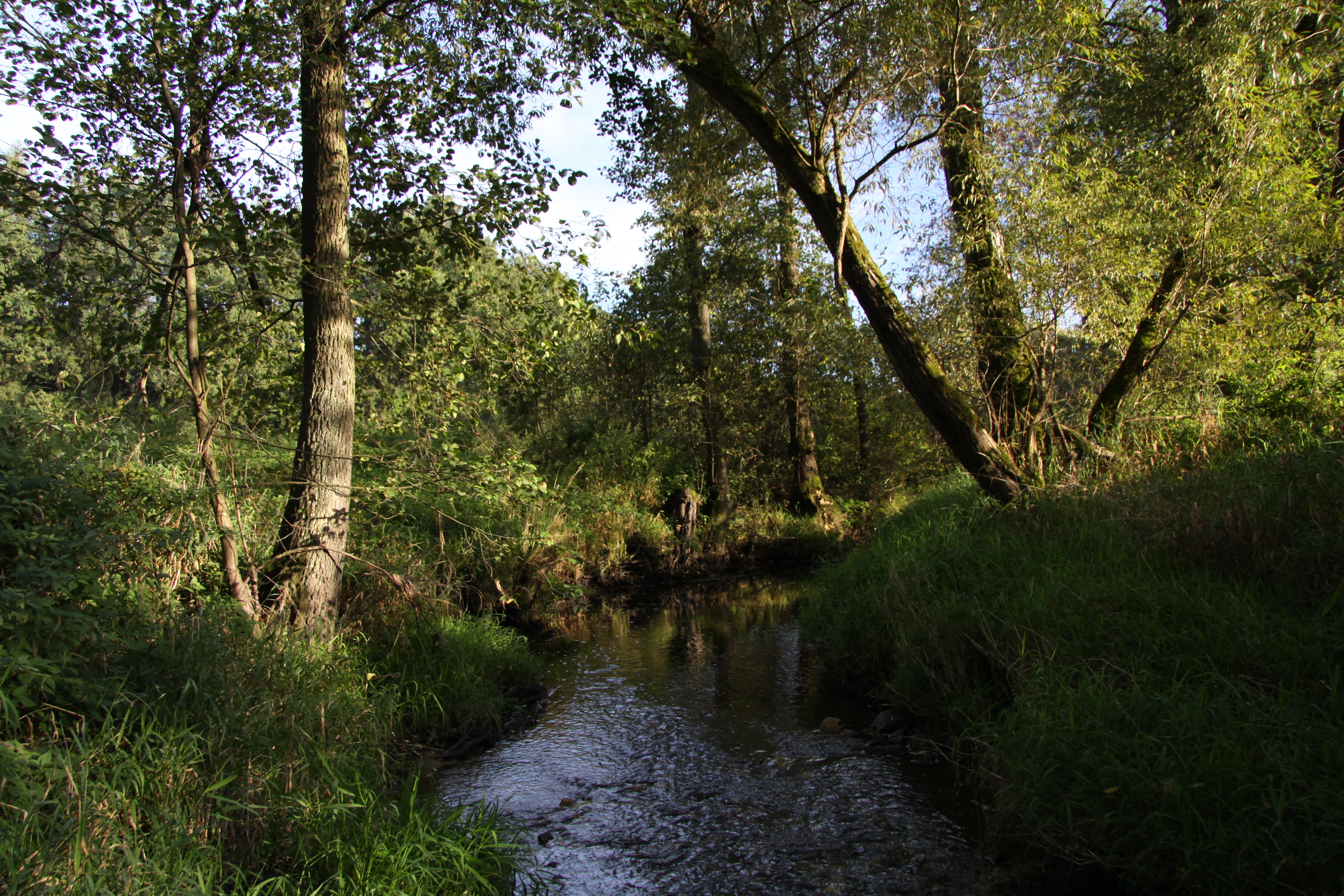
A small, calm river flowing through a lush green riparian forest, with trees overhanging the water and light filtering through the canopy.
A view of the Smutná river flowing through the riparian forest in the Smutný natural monument.

Smutný Natural Monument history and protected-area timeline

The area now known as Smutný Natural Monument was first given formal protection on 4 December 1985, when it was designated as a chráněný přírodní výtvor, or protected natural creation, under the conservation legislation then in force in Czechoslovakia. This initial designation reflected early recognition of the unusual, still freely meandering character of this segment of the Smutná River.

Following the major reorganization of Czech nature conservation law, Act No. 114/1992 Sb. transformed the site's status into a přírodní památka, a natural monument in the modern Czech system. This change aligned the site with the current national framework for smaller, ecologically focused protected areas, equivalent to IUCN Category III, and confirmed the long-term commitment to safeguarding the river's natural dynamics and riparian habitats. A 50-meter protective buffer zone was established around the monument to support this conservation purpose.

The protected site is described in the regional conservation volume *Chráněná území České republiky, svazek VIII: Českobudějovicko* (Czech Protected Areas, Volume VIII: České Budějovice Region), edited by Josef Albrecht and Peter Mackovčin, published in 2003 by the Agency for Nature Conservation and Landscape Protection of the Czech Republic together with EkoCentrum Brno. This reference helped cement Smutný's place within the documented network of South Bohemian protected natural sites.

Smutný Natural Monument landscape and geographic character

The landscape of Smutný Natural Monument is shaped almost entirely by the behavior of a small lowland river as it winds through a moderately undulating Bohemian valley. The protected corridor follows the Smutná River southeast of Sepekov, tucked beneath the slopes of Chlum hill. Elevations within the site range from about 414 to 430 meters above sea level, placing the monument firmly in the foothill-to-lowland transition typical of inland South Bohemia.

The defining visual and physical feature is the river's freely meandering planform. Rather than the straightened channel common to many agricultural Bohemian streams, the Smutná here continues to swing in pronounced bends, occasionally cutting into one bank while depositing material on the other. The flow alternates between swift, gravelly riffle sections and slower, shallower stretches, where fine sediments settle and quieter pools develop. This dynamic creates a constantly shifting mosaic of gravel bars, undercut banks, and sheltered margins along a relatively short reach.

The surrounding topography is gentle, with the wooded flanks of Chlum rising above the corridor and contributing leaf-litter and runoff that help maintain the riparian habitat. The underlying geology is Moldanubian biotite paragneiss, an ancient crystalline basement rock that gives the stream its characteristic bed structure and local gradient. Although the reserve itself is narrow, the wider scene is one of a quiet rural valley with mixed woodland, agricultural land, and the dark, slow water of the Smutná carving its own path through the landscape.

Smutný Natural Monument ecosystems, habitats, and plant life

The ecological character of Smutný Natural Monument revolves around the interface between flowing freshwater and the riparian zone that borders it. Because the river has not been straightened or hardened along this reach, the natural alternation of fast and slow water creates varied microhabitats: oxygen-rich riffles for invertebrates, quieter margins for amphibians and small fish, and sheltered undercut banks for burrowing animals. The shallow channel sections and small bars that form along the meanders are regularly reshaped by flood events, supporting the kind of disturbance-based habitats that have become scarce in heavily regulated Bohemian lowlands.

Riparian vegetation lines both sides of the stream, shading the water and stabilizing the banks in places while allowing natural erosion elsewhere. This woody fringe, combined with herbaceous marsh vegetation along slower sections, establishes the structural complexity of the corridor. The surrounding slopes of Chlum contribute mixed woodland, which raises the local habitat diversity and links the river corridor to the broader forested landscape.

Two protected plant species recorded here, bog bean and early marsh orchid, indicate the presence of genuine marshland conditions in parts of the floodplain. Bog bean is a classic indicator of nutrient-poor, groundwater-influenced wetlands, while early marsh orchid points to seasonally wet meadows and marshy edges. Their survival within the monument underlines the continued presence of small but ecologically valuable wetland microhabitats despite the surrounding agricultural land use.

Smutný Natural Monument wildlife and species highlights

Wildlife at Smutný Natural Monument is shaped primarily by the presence of a functioning, meandering river surrounded by a continuous band of riparian vegetation and connected to mixed woodland on the adjacent slopes. This linear habitat serves as both residence and travel corridor for species that depend on intact freshwater systems.

The Eurasian otter is the most consistently reported mammal of interest, occurring regularly along the protected stretch. Otters depend on clean water, abundant prey, and undisturbed banks with sufficient cover; their stable presence here is a strong indicator of the river's ecological health. The corridor is also used from time to time by goshawks, which hunt above the riparian woodland, and by common kingfishers, which rely on vertical or overhanging banks for nesting and on small fish for food.

While no comprehensive species inventory is documented in the source material, the combination of open meandering water, sheltered banks, riparian shrubs, and adjacent forest suggests a typical South Bohemian stream fauna, including freshwater invertebrates, small fish, amphibians in the slower sections, and typical woodland and waterside birdlife. The monument's value for wildlife lies less in rare endemic species than in functioning habitat for species that have retreated from more heavily modified Bohemian streams.

Smutný Natural Monument conservation status and protection priorities

The conservation significance of Smutný Natural Monument lies in its preservation of a river segment whose geomorphological behavior has remained essentially natural. In much of the South Bohemian countryside, small rivers have been straightened, deepened, or otherwise simplified to improve drainage and arable land, eliminating the lateral movement of the channel and the natural turnover of gravel, sediment, and bank vegetation. The Smutná here has escaped that fate, which is precisely the reason the site was first protected in 1985 and later reclassified as a natural monument under Act No. 114/1992 Sb.

By maintaining a free-meandering channel with naturally alternating riffles and pools, the monument helps preserve habitat structure that underpins otter populations, supports kingfisher nesting, and retains aquatic invertebrate communities adapted to variable flow conditions. The presence of protected wetland plants such as bog bean and early marsh orchid adds a botanical dimension, indicating that small marsh fragments continue to function along the river.

In administrative terms, the site falls within the Písek District of the South Bohemian Region and is managed as part of the Czech system of small natural monuments, equivalent to IUCN Category III. A 50-meter protective buffer zone surrounds the monument, reducing direct land-use pressure on the corridor and providing some additional space for natural river dynamics and associated habitats to develop.

Top sights and standout views in Smutný Natural Monument

Smutný Natural Monument's standout quality is its intact, freely meandering Smutná River, a 2.5 km corridor of naturally shifting bends between Chobot pond and the bridge Na Maděrovce. Equally important is the way the surrounding elements reinforce this central feature: riparian woodlands that shade the water, adjacent slopes of Chlum that contribute forest cover, and a 50-meter protective buffer that limits human alteration of the corridor.

The site's biological signals, including regular otter presence, occasional kingfisher and goshawk sightings, and the occurrence of protected wetland plants such as bog bean and early marsh orchid, all derive from this underlying geomorphological intactness. In a region where most streams have been simplified for agriculture, the monument preserves a small but genuine example of how a Bohemian lowland river once behaved.

Best time to visit Smutný Natural Monument

Smutný Natural Monument is a quiet, stream-side site rather than a large scenic park, and its character varies with the seasons in the ways typical of Bohemian lowland rivers. Late spring and early summer tend to bring the most active vegetation growth along the banks, when wetland plants such as early marsh orchid are in flower and insect life along the water is at its richest. This period can also be rewarding for birdwatching, including the chance of seeing kingfishers along the river.

Early autumn offers clearer water levels, colorful riparian foliage, and easier walking along the surrounding rural lanes. Winter visits can be atmospheric, with low water exposing gravel bars and meander structures that are otherwise hidden, though cold weather and damp paths require adequate preparation. Because the monument is small and unprotected in the legal sense does not restrict casual presence along public roads and paths, visitors generally experience it as a stop within a broader South Bohemian countryside outing rather than as a destination in itself.


Monthly climate preview

Long-term monthly temperature averages and precipitation patterns for Smutný

Smutný Climate Normals, Annual Temperature and Precipitation Records

Historical measurements from 1991 to 2000 trace the measured annual temperature rhythm and monthly precipitation distribution across representative coordinates in Smutný. Examining the complete twelve-month climate profile reveals detailed temperature ranges and precipitation variations across the protected area.
Annual mean8 °C
-3 °C19 °C
Jan-3°
Feb-1°
Mar
Apr
May13°
Jun17°
Jul19°
Aug19°
Sep14°
Oct
Nov
Dec-2°
Warmest month
July

18.9 °C

Coolest month
January

-2.7 °C

Wettest month
June

2.8 mm/day

Driest month
February

1.2 mm/day

Park location guide

Geography guide, regional context, and park location map for Smutný Natural Monument

Smutný Natural Monument park geography, regions, and map view in Czechia

Understand where Smutný Natural Monument sits in Czechia through a broader geographic reading of the surrounding landscape, nearby location context, and its mapped position within the national park landscape.

How Smutný Natural Monument fits into Czechia

Czech Republic is a landlocked Central European country with a population of approximately 10.9 million people. The nation was established as an independent state on January 1, 1993, following the dissolution of Czechoslovakia. Its capital and largest city is Prague, with other major urban centers including Brno, Ostrava, Plzeň, and Liberec.

Wider geography shaping Smutný Natural Monument in Czechia

The Czech Republic is a landlocked country in Central Europe. It is bordered by Germany to the west, Austria to the south, Poland to the northeast, and Slovakia to the southeast. The landscape is predominantly hilly, with the territory covering 78,871 square kilometers.

Map view of Smutný Natural Monument

Use this park location map to pinpoint Smutný Natural Monument in Czechia, understand its exact geographic position, and read its mapped placement within the surrounding landscape more clearly.

Pigeon | © OpenStreetMap contributors

Location context for Smutný Natural Monument

Jihočeský kraj

Explore the terrain, meandering watercourses, and riparian habitats of Smutný

Smutný Photos and Landscape Views: Visualising the Protected River Valley

Visual documentation reveals the natural river morphology and undisturbed riparian habitats that define Smutný. Photographic records offer direct insight into the meandering stream dynamics and protected valley ecosystems of South Bohemia.

A small, calm river flowing through a lush green riparian forest, with trees overhanging the water and light filtering through the canopy.

Park atlas

Compare surrounding regional geography and connected protected landscapes

Explore Protected Areas and Other Notable Parks Near Smutný

Browse other protected areas and nearby river corridors to compare regional conservation patterns across South Bohemia. Expanding beyond Smutný reveals connected lowland habitats and similar freshwater ecosystems within the wider Písek District geography.
A minimalist watercolor illustration depicting a soft, light-toned landscape with a row of trees on the right and distant, blurred hills in the background.
Natural monumentJihočeský kraj
About 9.9 km away#1 closest

West

Rukávečská obora: Natural Monument and Protected Beech Forest in Jihočeský kraj

A historic protected landscape in the Písek Highlands

Located in the Czech Republic, Rukávečská obora represents a significant natural monument defined by its 225-year-old beech stands. This site provides an essential look at the geological and botanical history of the Písek Highlands, serving as a key protected area for local invertebrate and bird species within the Vltava river valley watershed.

Area
0.067 km²
Established
1929
IUCN
V
Relief
Upland
A horizontal watercolor painting depicting a soft green landscape with scattered trees, rolling hills, and a pale pink sky on a white background.
Natural monumentJihočeský kraj
About 14 km away#2 closest

West

Sobědražský Prales Natural Monument: Protected Woodland Map and Geographic Context

An ancient oak and beech forest remnant in the South Bohemian Region.

Sobědražský prales represents a significant natural monument within the Czech Republic, protecting a rare stand of aged oaks and beeches. This site offers valuable insights into the historical composition of local forests, supporting critical biodiversity such as hole-nesting birds amidst the managed landscapes of the Jihočeský kraj.

Area
0.017 km²
Established
1986
IUCN
IV
Relief
Upland
Natural monumentStředočeský kraj
About 16 km away#3 closest

Northwest

Vrškámen Natural Monument: Granite Boulder Geography and Regional Protected Area Map

Geological preservation in the Středočeský kraj region

Vrškámen is a significant natural monument defined by its massive porphyritic syenite boulder. This compact protected site highlights the erosion history of the Central Bohemian Pluton. It functions as an essential reference for geologists interested in the residual rock forms of the Vlašimská pahorkatina hill country and the broader Sedlčansko geological landscape.

Established
1977
IUCN
III
Relief
Upland
Climate
Temperate
Natural monumentStředočeský kraj
About 22 km away#4 closest

North

Vápenické jezero Natural Monument: Wetland Geography and Protected Landscape in Středočeský kraj

Mapping the ecological features of the Sedlčany Basin.

Located in the Sedlčany Basin, Vápenické jezero is a protected pond system serving as a vital sanctuary for the fire-bellied toad and diverse wetland bird species. This entry provides a detailed look at its spring-fed water body, bulrush-covered surface, and long-standing ecological role in the broader landscape of central Bohemia.

Area
0.084 km²
Established
2013
IUCN
III
Relief
Upland
Natural monumentJihočeský kraj
About 22 km away#5 closest

West

V Obouch Natural Monument: Geographic Profile of the Lomnice River Valley

Protected riparian corridors and riverine terrain in Jihočeský kraj

Explore the unique geomorphology of V Obouch, a protected river segment in the Czech Republic. This site provides a detailed cross-section of alder floodplain forests, boulder rapids, and canyon-like terrain that defines the ecological character of the South Bohemian river network.

Area
0.051 km²
Established
1986
IUCN
IV
Relief
Upland
Nature reserveCzechia
About 23 km away#6 closest

Southeast

Veselská blata Nature Reserve: Basin Peatland and Wetland Geography in South Bohemia

A core protected mire site within the Czechia regional landscape.

Located in the Tábor District, Veselská blata protects rare transitional peatland ecosystems and bog pine woodlands. This reserve offers a clear view of basin mire hydrology, featuring a diverse mosaic of flooded pools and waterlogged meadows that remain vital to regional ecological conservation efforts in South Bohemia.

Area
4.538 km²
Established
2011
Relief
Lowland
Climate
Temperate
Watercolor painting of a tranquil pond scene with grassy shores, reeds, and rolling hills in the background under a soft sky.
Natural monumentJihočeský kraj
About 29 km away#7 closest

Southwest

Skalský rybník a Klokočínská olšina: Protected Wetland Landscapes and Forested Terrain

Natural Monument site in South Bohemia, Czech Republic

Located in the low-lying Českobudějovická pánev basin, this natural monument protects a tightly linked wetland system. The site encompasses open water, damp meadows, and broadleaf woodland, providing a refuge for protected waterbirds and rare pond-edge vegetation amidst the traditional landscape of South Bohemia.

Area
0.128 km²
Established
1986
IUCN
IV
Relief
Lowland
A watercolor painting showing a panoramic view of a marshy wetland area with sparse bare trees, grassy mounds, and rolling hills in the background.
Natural monumentJihočeský kraj
About 30 km away#8 closest

Southwest

Ražický rybník Natural Monument and Protected Wetland Geography in South Bohemia

Protected pond ecosystems and riparian terrain maps

Ražický rybník is a protected natural monument located in the Písek District of the Czech Republic, encompassing a shallow fishpond and surrounding meadows. This site serves as an essential breeding ground for waterbirds and provides a detailed look at the wetland mosaic characteristic of the Otava river lowlands. The area highlights the intersection of long-standing conservation efforts and habitat restoration through its diverse aquatic microhabitats.

Area
0.291 km²
Established
1986
IUCN
IV
Relief
Lowland

Common questions about visiting, size, designation, and location context for Smutný Natural Monument

Smutný Natural Monument FAQs for park facts, access, geography, and protected area context

Find quick answers about Smutný Natural Monument, including protected-area facts, park geography, trail and visitor context, and how the park fits into its surrounding country and regional landscape.
MoriAtlas Explorer

Continue Your Protected Areas Search Across the Global Atlas

Deepen your exploration by continuing the structured search for national parks and protected areas worldwide. Utilize the comprehensive filtering capabilities to compare different conservation landscapes and refine your understanding of global park geography. Discover more about the distribution and characteristics of protected natural areas.

Global natural geography