Mori Atlas logo
Protected landscapeŚnieżnicki Park Krajobrazowy

Examining the mountain massifs, karst terrain, and primeval forest boundaries of this Dolnoslaskie protected area.

Śnieżnicki Park Krajobrazowy: Geographic Atlas and Protected Landscape Mapping of the Eastern Sudetes

Śnieżnicki Park Krajobrazowy serves as a foundational protected landscape in the Eastern Sudetes of southwestern Poland. This atlas entry provides a detailed look at the varied terrain spanning the Masyw Snieznika massif and the Gory Zlote range, where ancient metamorphic rock formations meet complex river valleys and high mountain basins. Users can study the distribution of karst features, including major cave systems, alongside the structural composition of extensive spruce and beech forest belts.

landscape parkEastern Sudetesmountain forestsprimeval forestkarst cavesMount Śnieżnik

Śnieżnicki Park Krajobrazowy

Protected landscape

Park overview

Structured park overview, official facts, and landscape profile for Śnieżnicki Landscape Park

Śnieżnicki Landscape Park park facts, protected area profile, and essential visitor context

Review the core facts for Śnieżnicki Landscape Park, including designation, size, terrain, visitor scale, habitats, and operating context in one park-focused overview.

About Śnieżnicki Landscape Park

Śnieżnicki Landscape Park stretches across one of the most scenically and ecologically varied sections of Poland's Eastern Sudetes, where the high Eastern Sudeten ranges meet the watershed above the Upper Nysa trench. Covering about 288 square kilometres, the park unites two distinct mountain groups: the Masyw Śnieżnika massif, dominated by the 1,425-metre peak of Śnieżnik, and the Góry Złote range, including the wilder Góry Bialskie interior. Together they form a continuous wall of ridges running roughly north to south from the area near Złoty Stok in the north to the Opacz ridge in the south.

The protected landscape was created in 1981 to safeguard a representative fragment of the historic Sudeckie primeval forest, and to keep the visual and ecological character of this borderland mountain region intact. Around 60 percent of the park's area is forested, with spruce at higher elevations and mixed deciduous stands of beech, larch, hornbeam and elm on the lower slopes. The result is a layered mountain landscape in which forests blanket nearly every summit; only Śnieżnik itself rises above the treeline, where planted dwarf mountain pine marks the alpine zone.

Beyond its forests, the park is defined by its geology and relief. The underlying rocks of the Eastern Sudetes are a mix of Proterozoic and Carboniferous metamorphics, intruded by older granites, gneisses and crystalline schists, and capped in places by Neogene basalts. In the Krowiarki ridge, lenses of dolomite and marble have been hollowed into karst pits and caves, including the famous Jaskinia Niedźwiedzia, the Bear Cave at Kletno, one of the most important caves in Poland. Steep western flanks of the Śnieżnik massif are scored by short valleys whose rock ledges produce small seasonal waterfalls, adding further texture to the scenery.

For visitors, the park is a classic Sudeten hiking territory. The two main long-distance Sudeten trails traverse the area, alongside a network of shorter colour-marked routes, and the historic mountain hut at Hala pod Śnieżnikiem, "Na Śnieżniku", offers a focal point below the summit. The park also preserves cultural traces in its network of old roads, several still known by their pre-war German names, including Droga Albrechta, Droga Izabeli and Droga Staromorawska. These routes, combined with the natural richness of the reserves, give the park both an ecological significance and a strong identity as a destination for landscape exploration in the Polish-Czech borderland.

Quick facts and research context for Śnieżnicki Landscape Park

Śnieżnicki Landscape Park lies in the Lower Silesian Voivodeship, mainly within Kłodzko County, covering the Masyw Śnieżnika and Góry Złote ranges of the Eastern Sudetes. It was created in 1981 by resolution of the Provincial National Council in Wałbrzych to protect a representative fragment of the Sudeten primeval forest and the scenic high-mountain landscape. The park covers approximately 288 square kilometres, surrounded by a protective buffer zone of about 149 square kilometres, and contains five formal nature reserves, several ecological sites and a notable karst cave system.

Protection and recognition

Documented terrestrial protection scope and conservation management parameters

Śnieżnicki Park Krajobrazowy Protection Status and Regional Designation

Terrestrial protection status records establish the formal conservation framework and geographic scope for Śnieżnicki Park Krajobrazowy. Structured administrative data outlines the documented designation parameters without assuming external international recognition sources.

Protection details

Protection scope
Terrestrial
Transboundary protection
No
Buffer area
149 km²
Park context

Deeper park guide and search-rich context for Śnieżnicki Landscape Park

Śnieżnicki Landscape Park history, landscape, wildlife, and travel context

Explore Śnieżnicki Landscape Park through its history, landscape character, ecosystems, wildlife, conservation priorities, cultural context, and seasonal travel timing in a structured park guide built for atlas discovery and search intent.

Why Śnieżnicki Landscape Park stands out

The park is best known for hosting the summit region of Mount Śnieżnik, the highest peak of the Eastern Sudetes, and for preserving a large, relatively intact stand of the Sudeckie primeval forest with classic mid-mountain and upper-mountain spruce, beech and larch belts. It is also recognised for the Bear Cave in Kletno, one of Poland's most important karst caves, and for its traditional Sudeten hiking network that crosses the Hala pod Śnieżnikiem alpine meadow below the summit.
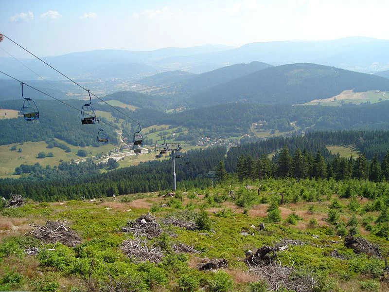
A high-angle view looking out over a mountain valley with a chairlift in the foreground, with rolling forested hills and mountain ranges in the distance under a hazy sky.
View of the Bialskie Mountains and the valley from the Czarna Gora chairlift.

Śnieżnicki Landscape Park history and protected-area timeline

Śnieżnicki Landscape Park was established on 28 October 1981 by Resolution No. 35/81 of the Provincial National Council in Wałbrzych, a decision later confirmed administratively by Regulation No. 3/93 of the Wałbrzych Voivode. The underlying motivation was to protect the visual and natural value of a representative slice of the Eastern Sudetes, where old-growth Sudeckie forest communities and the dramatic relief of the Śnieżnik and Góry Złote ranges were still largely intact.

Earlier in the 20th century, the biological richness of the area was already recognised scientifically. Before the Second World War, a biological research station operated in Międzygórze, on the slopes below Śnieżnik, documenting many of the rare and range-restricted species that the park still protects today. The current network of reserves within the park, including the Śnieżnik Kłodzki and Puszcza Śnieżnej Białki reserves and others, carries forward this earlier scientific interest by formally safeguarding the most valuable natural fragments.

The historical cultural layer of the landscape is equally visible. The park contains a network of old mountain roads laid out in earlier centuries, several of which retained their original German names into the modern era, such as Albrecht Strasse (Droga Albrechta), Puhu-Strasse (Droga Izabeli), Altmährishe Strasse (Droga Staromorawska) and Mährische Strasse (Droga Morawska). Together, these routes hint at long-standing cross-border traffic between the historical Bohemian and Moravian lands and the Kłodzko region, which the modern park now encloses within a single protected framework.

Śnieżnicki Landscape Park landscape and geographic character

The landforms of the park are strongly varied and built from contrasting geological materials. The Eastern Sudetes are composed of older metamorphic rocks ranging from late Proterozoic to Lower Carboniferous, granitic and gneissic intrusions of Carboniferous age, sedimentary covers from the Upper Carboniferous through the Quaternary, and cap-like Neogene and Palaeogene basalt outcrops. Within the park, the Masyw Śnieżnika and the Góry Bialskie are predominantly metamorphic, while the Góry Złote add gneisses, granites and crystalline schists; the Krowiarki ridge in turn hosts thick lenses of dolomite and marble that have weathered into karst landforms.

The resulting relief is unusually diverse for a single protected area. High-mountain basin landscapes alternate with the gentler forms of older mountains and old river valleys, and are edged by tectonic scarps whose erosional forms give the scenery much of its visual drama. The lowest points in the park lie near 400 metres around Mąkolno, while the highest reach 1,425 metres on Śnieżnik itself, producing a vertical span of more than a thousand metres within a relatively compact area. The western slopes of the Śnieżnik massif are comparatively steep and deeply cut by short stream valleys, whose rock steps form small waterfalls.

Karst is a defining element of the landscape wherever dolomite and marble appear. Solution of these rocks has produced caves, sinkholes and karst springs, with the Jaskinia Niedźwiedzia (Bear Cave) near Kletno the most important example and a natural monument within the park. The combination of high ridges, deep valleys, karst pockets and basalt-derived surfaces gives the park a layered scenery with many visual contrasts within short distances.

Śnieżnicki Landscape Park ecosystems, habitats, and plant life

The vegetation of the park is arranged in a clear altitudinal sequence typical of the Sudeten mid-mountains. Forests cover roughly 60 percent of the area, and almost every summit in the Eastern Sudetes inside the park is forested. The lower forest belt, the regiel dolny, climbs to about 800 to 900 metres and is dominated by spruce stands admixed with beech, larch, and occasional oak. Above this, the upper forest belt, the regiel górny, is largely pure spruce. The only summit that rises above the treeline is Śnieżnik itself; here the so-called alpine zone is artificially created by plantation of dwarf mountain pine, with examples of stone pine also planted at high elevations.

Within the protection zone, the park preserves remnants of the historic Sudeckie primeval forest with beech, elm, larch and hornbeam, giving the landscape an old-fashioned Central European character in places rarely disturbed by modern forestry. The flora is rich in protected species, including Daphne mezereum (wawrzynek wilczełyko), the ostrich fern Pióropusznik strusi, Podrzeń żebrowiec, Carlina acaulis (dziewięćsił bezłodygowy), Lilium martagon (lilia złotogłów), clubmosses, and a wide range of orchids.

The park is also notable as a refuge for several species whose only known Sudeten or Lower Silesian sites are located here. These include a single flowering example of the orchid Storczyk kukawka rediscovered in 2010 after a previous record from 1979, the rare Wyblin jednolistny with its only Lower Silesian station in the Kleśnica valley, and the Sudeten yellow violet, which has two of its few non-Karkonosze sites within the park's reserves. This combination of intact zonation, ancient forest composition and rare relicts gives the park a strong botanical identity within the Polish mountain protected-area network.

Śnieżnicki Landscape Park wildlife and species highlights

The fauna of Śnieżnicki Landscape Park has long been recognised as exceptional, a status that goes back to the pre-war biological research station at Międzygórze, which documented the area's rare and range-restricted species. The park's cave systems in particular host a diverse bat community, including the grey long-eared bat, brown long-eared bat, and the rarer Natterer's bat and greater mouse-eared bat species. These cave-dwelling mammals are a key conservation interest, alongside the broader mammal community of the forests above.

The larger mammals of the park include the Alpine chamois, red deer, roe deer, Mediterranean mouflon, wild boar, red fox, European badger, pine marten, stoats and weasels, and small arboreal species such as the edible dormouse, hazel dormouse and forest dormouse. Among amphibians and reptiles, common European adder, grass snake and slow worm are present, while the cold mountain streams sustain populations of the rare European brook lamprey and the native brown trout.

Birdlife is especially diverse, with about 100 recorded species. The park is an important refuge for large grouse such as the capercaillie and black grouse, the three-toed woodpecker associated with old spruce forests, the white-throated dipper in fast mountain streams, twite, hazel grouse, black stork, and the eagle owl. The mix of primeval-forest specialists, grouse, owls and stream-dependent species makes the park one of the more important bird areas in the Polish Sudetes, and underlines why its broadest forest reserves, such as Puszcza Śnieżnej Białki and Śnieżnik Kłodzki, were designated as nature reserves.

Śnieżnicki Landscape Park conservation status and protection priorities

The park's conservation significance rests on its unusually large, well-preserved forests and on the layered Sudeten ecosystems they support. The protected area was created primarily because of the high scenic and landscape value of the Śnieżnik massif and the Góry Złote, and because these mountains retain one of the best surviving fragments of the Sudeckie primeval forest with its characteristic mix of beech, elm, hornbeam and larch alongside spruce. Almost all summits in the park remain forested, a pattern that is now rare in the Central European mid-mountains and that gives the area exceptional value for forest ecology, carbon storage and habitat continuity.

Within the park, the most valuable natural fragments receive stronger protection through a system of five nature reserves: Śnieżnik Kłodzki, Puszcza Śnieżnej Białki, Nowa Morawa, Jaskinia Niedźwiedzia (Bear Cave), and Wodospad Wilczki (Wilczki Waterfall), supplemented by ecological sites such as Hałda Storczykowa and Rogóżka, the Radochowska Cave as an inanimate natural monument, and additional Krowiarki and Mały Śnieżnik reserves. Together these protected fragments safeguard rare plant stations that are the only ones known in the Sudetes or in all of Lower Silesia, and provide a stable home for cave bat colonies and Sudeten grouse populations.

A 149 square kilometre buffer zone around the main park area extends protection outward across neighbouring slopes and valleys, softening the boundary between the protected core and surrounding settlements such as Bystrzyca Kłodzka, Lądek-Zdrój, Stronie Śląskie, Międzylesie and Złoty Stok. This combination of a sizable core area, multiple formal reserves, ecological sites and a generous buffer is what gives the park its importance within Poland's network of protected landscape areas in the Sudeten borderland.

Śnieżnicki Landscape Park cultural meaning and human context

The park lies within a borderland that has long connected the historical lands of Silesia, Bohemia and Moravia. Its old road network reflects this layered past: routes such as Droga Albrechta (Albrecht Strasse), Droga Izabeli (Puhu-Strasse), Droga Marianny (Mariannenstrasse), Droga Morawska (Mährische Strasse) and Droga Staromorawska (Altmährishe Strasse) preserve pre-war German names alongside their Polish forms, marking centuries-old connections across the Kłodzko region and into the neighbouring Czech lands.

The mountain communities around the park, including Międzygórze, Stronie Śląskie, Lądek-Zdrój and Złoty Stok, also carry a regional identity shaped by spas, mining and traditional Sudeten mountain culture. The research history of the area is part of this story too: the pre-war biological station at Międzygórze established the park's scientific reputation long before formal protection arrived. The shelter "Na Śnieżniku" on Hala pod Śnieżnikiem continues a long-standing tradition of Sudeten mountain hospitality, anchoring the cultural as well as the tourist life of the park.

Top sights and standout views in Śnieżnicki Landscape Park

Śnieżnicki Landscape Park combines the highest ground of the Eastern Sudetes with one of Poland's most important karst caves and one of its largest remaining blocks of Sudeten primeval forest. Mount Śnieżnik at 1,425 metres anchors the northern part of the park and gives its name to the protected area, while the Góry Złote and Góry Bialskie extend a continuous mountain landscape southward. Five nature reserves, a network of old roads, layer after layer of forest belts, and a Sudeten hiking tradition focused on the classic hut at Hala pod Śnieżnikiem together define the park as a complete mountain landscape experience.

Best time to visit Śnieżnicki Landscape Park

The park is best experienced in the warmer months when the Sudeten hiking network and mountain hut are fully active, generally from late spring through early autumn. Late spring brings fresh forest greens and flowing mountain streams, while summer offers the longest hours for combining summits, caves and waterfalls within a single visit. Autumn turns the beech and larch stands into russet colour and is widely regarded as a particularly scenic period in the Sudeten mid-mountains; winter brings snow to the upper slopes, but conditions on the high trails can be demanding and access above Hala pod Śnieżnikiem is more limited.

Monthly climate preview

Long-term representative monthly temperature and precipitation data patterns

Śnieżnicki Park Krajobrazowy Climate Normals and Annual Temperature Rhythm

Representative coordinate records outline the measured annual temperature and precipitation rhythm across Śnieżnicki Park Krajobrazowy from 1991 to 2020. Detailed monthly normals provide deeper insight into long-term averages for comparison across the protected landscape.
Annual mean8 °C
-3 °C19 °C
Jan-3°
Feb-2°
Mar
Apr
May12°
Jun16°
Jul19°
Aug18°
Sep13°
Oct
Nov
Dec-2°
Warmest month
July

18.6 °C

Coolest month
January

-3.4 °C

Wettest month
July

3.1 mm/day

Driest month
February

1.5 mm/day

Park location guide

Geography guide, regional context, and park location map for Śnieżnicki Landscape Park

Śnieżnicki Landscape Park park geography, regions, and map view in Poland

Understand where Śnieżnicki Landscape Park sits in Poland through a broader geographic reading of the surrounding landscape, nearby location context, and its mapped position within the national park landscape.

How Śnieżnicki Landscape Park fits into Poland

Poland, officially the Republic of Poland, is a Central European country spanning from the Baltic Sea in the north to the Carpathian Mountains in the south. It borders Germany, Czech Republic, Slovakia, Ukraine, Belarus, Lithuania, and Kaliningrad Oblast. The country has a temperate climate, diverse landscapes, and is known for its rich history, cultural heritage, and strong economic position within the EU.

Wider geography shaping Śnieżnicki Landscape Park in Poland

Poland occupies 312,696 km2 in Central Europe, extending from the Baltic Sea coast in the north to the Sudetes and Carpathian Mountains in the south. It borders Germany to the west, Czech Republic and Slovakia to the south, Ukraine and Belarus to the east, and Lithuania and Kaliningrad Oblast to the northeast. The landscape includes lowland plains, uplands, and mountain ranges.

Map view of Śnieżnicki Landscape Park

Use this park location map to pinpoint Śnieżnicki Landscape Park in Poland, understand its exact geographic position, and read its mapped placement within the surrounding landscape more clearly.

Pigeon | © OpenStreetMap contributors

Location context for Śnieżnicki Landscape Park

Dolnośląskie
Recorded earthquake history

View Historical Seismic Records and Earthquake History for Śnieżnicki Park Krajobrazowy

Access a structured catalogue of historical earthquakes documented near the boundaries of Śnieżnicki Park Krajobrazowy. This MoriAtlas collection maps seismic events by location to provide a clear view of geological activity throughout the Eastern Sudetes mountain ranges.

Śnieżnicki Park Krajobrazowy Earthquake History

Catalogued events

9 events

Strongest magnitude

Magnitude 3.8

Most recent event

Oct 25, 2005

This history includes earthquakes recorded inside the park or within 50 km of its borders

Examine the mountain forests, rocky terrain, and protected habitats shaping this Sudeten landscape.

Śnieżnicki Park Krajobrazowy Photos and Landscapes: Visual Exploration of the Eastern Sudetes

Visual records capture the dramatic vertical relief, ancient spruce forests, and karst landforms defining Śnieżnicki Park Krajobrazowy across its high mountain zones. Examining these protected area views reveals the intricate topography, valley systems, and ecological character of the Eastern Sudetes.

A high-angle view looking out over a mountain valley with a chairlift in the foreground, with rolling forested hills and mountain ranges in the distance under a hazy sky.

Park atlas

Compare adjacent mountain terrain and connected regional protected areas across the Eastern Sudetes.

Explore Other Parks Near Śnieżnicki Park Krajobrazowy and Surrounding Protected Landscapes

Browse nearby national parks and protected landscapes sharing the rugged terrain of the Polish borderland. Extending exploration beyond Śnieżnicki Park Krajobrazowy reveals broader regional geography and diverse mountain ecosystems.
Natural monumentOlomouc Region
About 2.3 km away#1 closest

East

Vodopády Stříbrného potoka: Natural Monument and Mountain Stream Geography in Olomouc Region

Geomorphological landmark within the Rychlebské hory mountain range

Vodopády Stříbrného potoka is a protected natural monument in the Czech Republic, encompassing a narrow, steep-sided valley defined by bedrock cascades. This compact site highlights mountain stream geomorphology and serves as a significant feature in the Rychlebské hory, offering insight into the distinctive eroded terrain of the Jeseník District.

Area
0.017 km²
Established
1965
IUCN
III
Relief
Mountain
A soft, artistic watercolor painting showing a stylized, rolling green landscape with forests, meadows, and a winding path.
Nature reserveOlomouc Region
About 4.7 km away#2 closest

Northeast

Račí údolí Nature Reserve: A Protected Forest Valley in the Olomouc Region

Geographic boundaries and metamorphic woodland terrain

Račí údolí serves as a vital protected area in the Jeseník foothills, showcasing remnants of oak and beech forests amidst rocky gneiss terrain. This valley map highlights the intersection of natural stream-cut geography and centuries of human cultural presence, providing a dense, immersive look at regional forest conservation and metamorphic geology.

Area
0.62 km²
Established
1998
IUCN
IV
Relief
Upland
Protected areaLower Silesian Voivodeship
22 km away#3 closest

North

Wzgórza Strzelińskie Protected Area: Geographic Atlas and Regional Landscape Mapping

A diverse Natura 2000 hill landscape in southwestern Poland.

Spanning over 3,800 hectares, Wzgórza Strzelińskie functions as a vital refuge for specialized European habitats. The area features a complex intersection of beech-dominated forests, rocky cliff communities, and traditional meadows that define the local Silesian topography. This record provides a detailed look at the park boundaries, ecosystem distribution, and the natural terrain that shapes this conservation site.

Area
38.362 km²
Relief
Upland
Water
Minor water
Natural monumentKrálovéhradecký kraj
About 23 km away#4 closest

West

Velká louka Natural Monument: Geographic Profile of an Orlické hory Wetland Habitat

Protected peat meadow terrain in the Královéhradecký kraj region.

Velká louka represents a focused protected landscape in the Czech Republic, known for its rare botanical composition and wetland-dependent amphibian pools. The site highlights the importance of small-scale conservation efforts within the mountainous Orlické hory region, offering a clear example of specialized meadow ecology in a submontane climate.

Area
0.023 km²
Established
1982
IUCN
IV
Relief
Upland
Natural monumentOlomouc Region
23 km away#5 closest

South

Sobotín, domov důchodců Protected Natural Monument in the Czech Republic

A specialized Olomouc Region conservation site and habitat refuge

Examine the geographic and ecological boundaries of Sobotín, domov důchodců, a protected natural monument situated in the Olomouc Region. Learn how this site provides essential environmental stability within its broader regional setting, serving as a critical example of small scale habitat conservation in northern Moravia.

Area
0.001 km²
Established
2013
IUCN
III
Relief
Lowland
A horizontal watercolor illustration depicting a prominent weathered sandstone rock formation surrounded by forest, set against a soft, light-filled sky.
National parkDolnośląskie
24 km away#6 closest

Northwest

Park Narodowy Gór Stołowych: A Geologic Atlas of Table Mountains in Lower Silesia

Mapping sandstone labyrinths and protected forest plateaus in the Sudetes

Explore the definitive map and geographic profile of Park Narodowy Gór Stołowych, a protected area characterized by its horizontal sandstone layers and dramatic rock towers. This atlas entry provides insight into the park's sedimentary landscape, covering iconic summit plateaus, dense forest environments, and the contrasting igneous geology of the surrounding terrain.

Area
63.402 km²
Established
1993
Visitors
1.3M annual
Relief
Mountain
Watercolor artwork depicting a landscape with green hills, distant mountains, and pastel sky
National parkLower Silesian Voivodeship
24 km away#7 closest

West

Stołowe Mountains National Park: Explore Poland's Sandstone Rock Cities and Protected Terrain

National Park in Lower Silesian Voivodeship: Geological Wonders.

Stołowe Mountains National Park is a protected national park in Poland celebrated for its unparalleled sandstone geological features. Within the Lower Silesian Voivodeship, the park showcases a dramatic landscape dominated by flat-topped rock plateaus, natural labyrinths, and vertical sandstone formations that create a visually stunning and geologically significant environment. Its protected status ensures the preservation of these unique landforms and the rare ecosystems, such as raised peat bogs, offering extensive opportunities for atlas exploration and understanding the region's distinct natural context.

Area
63.39 km²
Established
1993
IUCN
II
Visitors
1.3M annual
Protected areaOpole Voivodeship
25 km away#8 closest

Northeast

Przyłęk nad Białą Głuchołaską: Protected Area and River Landscape Geography in Poland

Mapped riparian habitats within Opole Voivodeship

Focusing on the Biała Głuchołaska river valley, this area preserves a complex system of active river channels, gravel bars, and terrace forests. The landscape transitions from wet willow-poplar galleries to stable oak-hornbeam communities. As a Natura 2000 site in the Opole Voivodeship, the terrain provides a clear look at submontane river processes interacting with lowland forest habitats.

Area
3.193 km²
Relief
Lowland
Climate
Temperate
Scope
Terrestrial

Common questions about visiting, size, designation, and location context for Śnieżnicki Landscape Park

Śnieżnicki Landscape Park FAQs for park facts, access, geography, and protected area context

Find quick answers about Śnieżnicki Landscape Park, including protected-area facts, park geography, trail and visitor context, and how the park fits into its surrounding country and regional landscape.
MoriAtlas Explorer

Continue Your Protected Areas Search Across the Global Atlas

Deepen your exploration by continuing the structured search for national parks and protected areas worldwide. Utilize the comprehensive filtering capabilities to compare different conservation landscapes and refine your understanding of global park geography. Discover more about the distribution and characteristics of protected natural areas.

Global natural geography