
Mori Atlas logo
Natural monumentSokolí hnízdo a bažantnice

A mature deciduous woodland protected area situated along the Stropnice River in the South Bohemian region.

Sokolí hnízdo a bažantnice Natural Monument: Geographic Profile and Protected Landscape Context

Sokolí hnízdo a bažantnice serves as a protected natural monument in the Czech Republic, preserving a representative fragment of mature broadleaf forest within the Třeboň Basin. This geographic site, located in the Jihočeský kraj, provides a sanctuary for specialized saproxylic invertebrates, including the hermit beetle, while highlighting traditional managed woodland heritage. The area reflects the intricate ecological character of the South Bohemian river valleys and fishpond-dominated landscapes.

natural monumentbroadleaf woodlanddeciduous forestTřeboň BasinSouth BohemiaNatura 2000
A vibrant flat-design illustration showing a winding river flowing through a forested mountain valley with a waterfall visible in the background.

Sokolí hnízdo a bažantnice

Natural monument

Park overview

Structured park overview, official facts, and landscape profile for Sokolí hnízdo a bažantnice

Sokolí hnízdo a bažantnice park facts, protected area profile, and essential visitor context

Review the core facts for Sokolí hnízdo a bažantnice, including designation, size, terrain, visitor scale, habitats, and operating context in one park-focused overview.

About Sokolí hnízdo a bažantnice

Sokolí hnízdo a bažantnice is a small but ecologically focused protected natural monument in the South Bohemian Region of the Czech Republic. It lies within the Třeboňská pánev, or Třeboň Basin, a distinctive lowland landscape whose network of fishponds, forested edges, and slow-moving rivers has shaped both regional identity and local biodiversity for centuries.

The protected area is centered on the left bank of the Stropnice River, northwest of the town of Nové Hrady. Covering roughly 47 hectares, it extends across several cadastral territories, including Nové Hrady itself and the smaller settlements of Štiptoň and Údolí u Nových Hradů. Despite its modest size, the site has been recognized for its conservation value as part of the European Union's Natura 2000 network, where it is classified as a European site of community importance, or evropsky významná lokalita.

The primary purpose of the designation is to safeguard surviving patches of broadleaf woodland in a region whose historic landscape has been heavily shaped by fishpond management and forestry. These deciduous communities host specialized habitats, including old trees and decaying wood, which in turn support rare and threatened invertebrate species. The name of the monument itself reflects two strands of land use: "Sokolí hnízdo," referring to a falcon's nest or raptor nesting site, and "bažantnice," a traditional term for a managed woodland preserve associated with pheasants. Together, the name hints at the site's long history as a wooded refuge within an otherwise open and managed South Bohemian landscape.

The area is locally accessible to walkers via a blue-marked tourist trail leading from Nové Hrady, making it a quiet destination for visitors interested in South Bohemian nature, traditional land use, and the small but important protected areas that link the region's forests with the broader European ecological network.

Quick facts and research context for Sokolí hnízdo a bažantnice

Sokolí hnízdo a bažantnice is a Czech natural monument (přírodní památka) located in the České Budějovice District of the South Bohemian Region. It lies in the Třeboň Basin northwest of Nové Hrady, on the left bank of the Stropnice River. The protected territory was established on 2 January 2014 by the Regional Authority of the South Bohemian Region, and spans roughly 47 hectares across the cadastral areas of Nové Hrady, Štiptoň, and Údolí u Nových Hradů. It protects a European site of community importance centered on broadleaf woodland and the rare habitats and species associated with it.

Protection and recognition

Analysis of terrestrial protected area designation history and Natura 2000 records

Sokolí hnízdo a bažantnice Protection Status and Documented Recognition Data

Sokolí hnízdo a bažantnice holds documented terrestrial protection status established in 2014 alongside official Natura 2000 recognition sources. Reviewing these records clarifies the management scope, international listings, and baseline designation history associated with the protected landscape.

International recognition

Protection details

Protection scope
Terrestrial
Designated year
2014
Transboundary protection
No
Park context

Deeper park guide and search-rich context for Sokolí hnízdo a bažantnice

Sokolí hnízdo a bažantnice history, landscape, wildlife, and travel context

Explore Sokolí hnízdo a bažantnice through its history, landscape character, ecosystems, wildlife, conservation priorities, cultural context, and seasonal travel timing in a structured park guide built for atlas discovery and search intent.

Why Sokolí hnízdo a bažantnice stands out

Sokolí hnízdo a bažantnice is best known for its stands of broadleaf trees in the Třeboň Basin and for the rare invertebrate fauna tied to these mature deciduous habitats, most notably the hermit beetle (Osmoderma barnabita). The site also reflects the traditional Czech land-use concept of a bažantnice, a managed woodland historically maintained to support pheasant populations. Together, these features make it a small but ecologically meaningful protected area within the broader South Bohemian landscape of fishponds, forests, and river valleys.
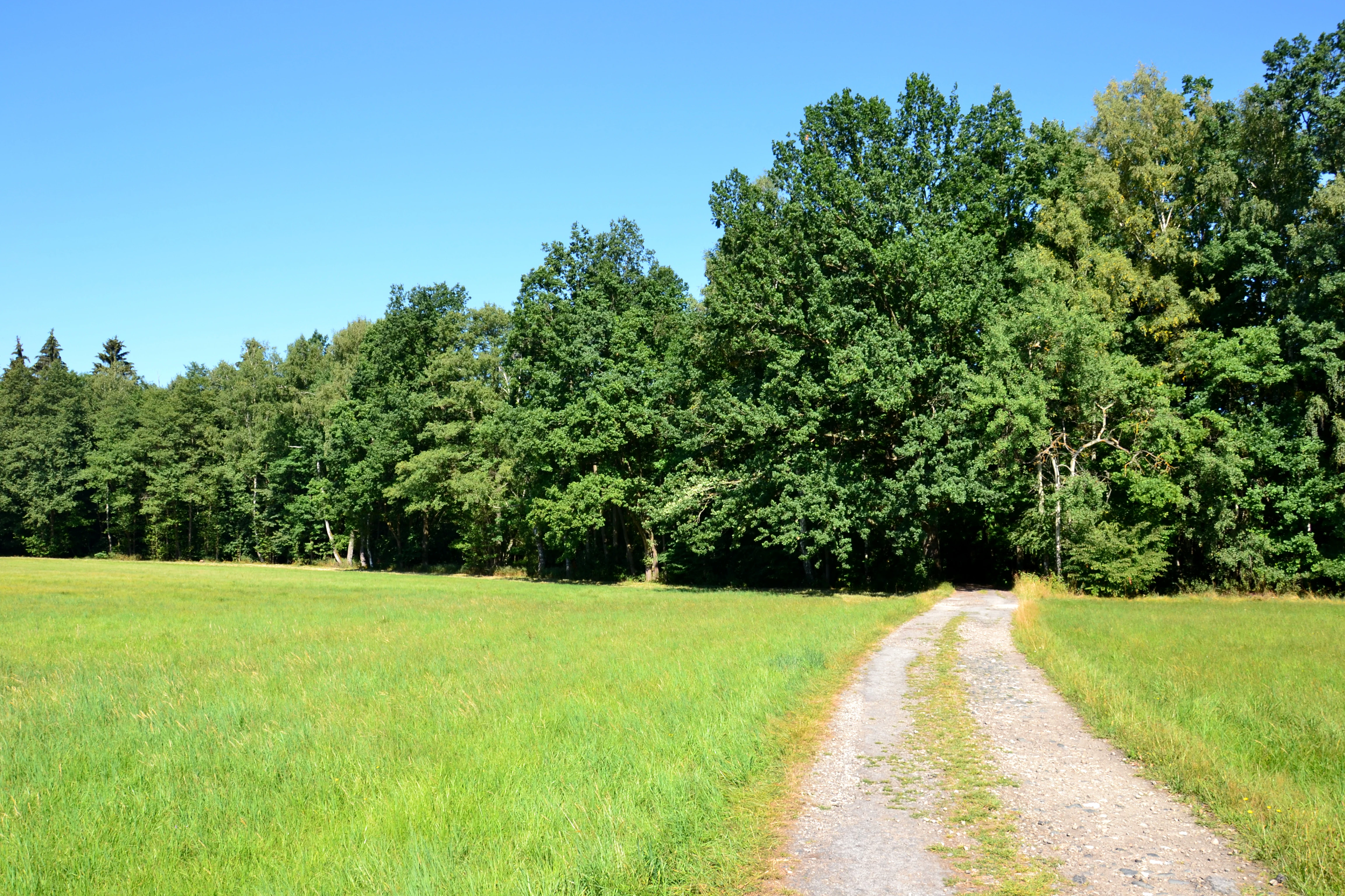
A green, grassy meadow with a dirt path leading toward a dense, green deciduous forest under a clear blue sky.
A meadow and dirt path bordering the deciduous forest of the Sokolí hnízdo a bažantnice natural monument.

Sokolí hnízdo a bažantnice history and protected-area timeline

Sokolí hnízdo a bažantnice was formally declared a natural monument on 2 January 2014 by the Regional Authority of the South Bohemian Region (Krajský úřad Jihočeského kraje). The designation was prompted by the recognition of an overlapping European site of community importance, drawing attention to the site's stands of broadleaf trees and the rare habitats and species they support.

The name itself reflects older layers of land history. The "bažantnice" portion is rooted in the tradition of managed woodland preserves maintained in Bohemia to sustain pheasant populations, while "Sokolí hnízdo" evokes the presence of nesting raptors, historically a notable feature of mature forests in this part of the Třeboň Basin.

Sokolí hnízdo a bažantnice landscape and geographic character

The protected area sits within the Třeboň Basin, a low-lying landscape in South Bohemia shaped by glacial sediments, extensive fishpond systems, and networks of slow rivers. The Stropnice River forms a key geographic anchor for the site, with the protected territory occupying its left bank northwest of Nové Hrady.

Elevations within the natural monument range roughly between 475 and 535 meters above sea level, placing it firmly within the gently undulating lowland character of the region rather than in true upland terrain. The terrain combines wooded slopes and forest margins with clearings and meadow edges, the kind of mosaic typical of the transitional zones between South Bohemian fishpond landscapes and broader forested tracts.

Sokolí hnízdo a bažantnice ecosystems, habitats, and plant life

Ecologically, the site is defined by its stands of broadleaf trees, which form the core of its habitat value within the Třeboň Basin. In a regional landscape long dominated by coniferous forestry and fishpond management, these deciduous communities are relatively scarce and therefore disproportionately important for biodiversity.

The protection of this woodland also extends to the biotopes tied to it, particularly old trees, decaying wood, and the microhabitats that support specialized invertebrates. The site's status as a European site of community importance highlights its role within the Natura 2000 network, where such broadleaf woodland fragments are recognized for their contribution to habitat connectivity and the survival of species with strong dependencies on mature deciduous forests.

Sokolí hnízdo a bažantnice wildlife and species highlights

The wildlife profile of Sokolí hnízdo a bažantnice is shaped above all by the invertebrate fauna associated with its mature deciduous trees. The site is known to harbor the hermit beetle (Osmoderma barnabita, listed in the source as Osmoderma barnabita), a saproxylic species that depends on old broadleaf trees with cavities and decaying heartwood.

The presence of breeding raptors is reflected in the name "Sokolí hnízdo," suggesting that the broader woodland mosaic has historically supported nesting birds of prey, although the available source material does not detail current raptor populations. The site's relatively small size and wooded character make it more significant for specialist forest species than for large mammal populations.

Sokolí hnízdo a bažantnice conservation status and protection priorities

The natural monument was established in 2014 specifically to protect an overlapping European site of community importance, underscoring its role within the European Union's Natura 2000 framework. Its conservation significance lies in preserving a representative patch of broadleaf woodland and the biotopes associated with it within the largely altered Třeboň Basin landscape.

By safeguarding old trees, decaying wood, and the invertebrate communities that depend on them, the designation supports one of the most species-rich yet vulnerable microhabitats in Central European lowland forests. The site's small footprint makes it a focused conservation target rather than a broad landscape reserve, but its ecological value is meaningful within the wider South Bohemian network of protected areas.

Sokolí hnízdo a bažantnice cultural meaning and human context

The name "bažantnice" reflects a long-standing Bohemian land-use tradition of managing woodlands to sustain pheasant populations, an old practice tied to aristocratic hunting estates and later to state-managed forestry. Combined with "Sokolí hnízdo," suggesting historic raptor nesting, the name evokes a wooded refuge that has long stood out from the surrounding fishpond landscape of the Třeboň Basin.

Top sights and standout views in Sokolí hnízdo a bažantnice

Sokolí hnízdo a bažantnice stands out for the combination of a Natura 2000-level broadleaf woodland site with a traditional Czech land-use heritage, reflected in the "bažantnice" element of its name. Its protected broadleaf stands support rare invertebrate habitats, and the surrounding Třeboň Basin context links it to one of the most distinctive cultural landscapes in South Bohemia. The site offers a compact example of how small protected areas can preserve ecologically valuable forest fragments within a heavily modified regional landscape.

Best time to visit Sokolí hnízdo a bažantnice

The gentle seasons of late spring and early summer are typically well suited to experiencing South Bohemian lowland woodlands like Sokolí hnízdo a bažantnice, when broadleaf foliage is fully developed, ground flora is active, and temperatures are mild. Autumn can also be appealing, when deciduous trees take on color and the surrounding landscape of the Třeboň Basin shifts toward its quieter winter character. As a forested lowland site, it is largely free of severe alpine weather constraints, and visits along the blue-marked trail from Nové Hrady are most comfortable outside the wettest periods and the coldest winter spells.

Monthly climate preview

Long-term representative temperature ranges and monthly precipitation patterns

Sokolí hnízdo a bažantnice Climate Normals and Annual Weather by Month

Sokolí hnízdo a bažantnice experiences measured temperature and precipitation variations across twelve recorded intervals based on NASA climatology data. Examining the complete monthly profile provides deeper clarity on long-term thermal rhythms and precipitation averages for this protected terrain.
Annual mean8 °C
-3 °C19 °C
Jan-3°
Feb-2°
Mar
Apr
May13°
Jun17°
Jul19°
Aug19°
Sep13°
Oct
Nov
Dec-2°
Warmest month
July

18.7 °C

Coolest month
January

-3 °C

Wettest month
July

2.9 mm/day

Driest month
February

1.1 mm/day

Park location guide

Geography guide, regional context, and park location map for Sokolí hnízdo a bažantnice

Sokolí hnízdo a bažantnice park geography, regions, and map view in Czechia

Understand where Sokolí hnízdo a bažantnice sits in Czechia through a broader geographic reading of the surrounding landscape, nearby location context, and its mapped position within the national park landscape.

How Sokolí hnízdo a bažantnice fits into Czechia

Czech Republic is a landlocked Central European country with a population of approximately 10.9 million people. The nation was established as an independent state on January 1, 1993, following the dissolution of Czechoslovakia. Its capital and largest city is Prague, with other major urban centers including Brno, Ostrava, Plzeň, and Liberec.

Wider geography shaping Sokolí hnízdo a bažantnice in Czechia

The Czech Republic is a landlocked country in Central Europe. It is bordered by Germany to the west, Austria to the south, Poland to the northeast, and Slovakia to the southeast. The landscape is predominantly hilly, with the territory covering 78,871 square kilometers.

Map view of Sokolí hnízdo a bažantnice

Use this park location map to pinpoint Sokolí hnízdo a bažantnice in Czechia, understand its exact geographic position, and read its mapped placement within the surrounding landscape more clearly.

Pigeon | © OpenStreetMap contributors

Location context for Sokolí hnízdo a bažantnice

Jihočeský kraj
Recorded earthquake history

Explore Recorded Seismic Activity Near Sokolí hnízdo a bažantnice

Review the history of seismic events identified in the geography surrounding Sokolí hnízdo a bažantnice. MoriAtlas provides a clear catalogue of recorded epicentres, allowing for the analysis of regional seismic activity without implying specific local causation or future hazard conditions.

Sokolí hnízdo a bažantnice Earthquake History

Catalogued events

1 event

Strongest magnitude

Magnitude 3.4

Most recent event

Mar 11, 2000

This history includes earthquakes recorded inside the park or within 50 km of its borders

Visual exploration of mature deciduous forests and protected lowland habitats in the Třeboň Basin

Sokolí hnízdo a bažantnice Photos and Landscape Scenery

Visual documentation reveals the dense broadleaf tree stands and riverbank terrain defining Sokolí hnízdo a bažantnice. Examining these protected habitats provides clearer insight into the specialized South Bohemian woodland ecology.

A green, grassy meadow with a dirt path leading toward a dense, green deciduous forest under a clear blue sky.

Park atlas

Compare nearby South Bohemian reserves and connected regional forest habitats.

Parks Near Sokolí hnízdo a bažantnice and Surrounding Protected Landscapes

Browse protected areas and river valley reserves located near Sokolí hnízdo a bažantnice. Geographic comparisons reveal broader lowland conservation networks across the Třeboň Basin.
Natural monumentJihočeský kraj
1.4 km away#1 closest

South

Veveřský potok Natural Monument: Mapped Stream Valley and Regional Geography

Protected freshwater corridors in the Jihočeský kraj foothills

Spanning five kilometers of forested stream valley, Veveřský potok protects a critical mountain catchment area near the Czech-Austrian border. This natural monument is recognized for preserving the ecological integrity of freshwater habitats and the surrounding transition between diverse elevational zones in the South Bohemian Region.

Area
0.345 km²
Established
2013
IUCN
III
Relief
Upland
Nature reserveJihočeský kraj
19 km away#2 closest

Southwest

Velký Hodonický rybník Nature Reserve: Regional Geography and Protected Wetland Atlas

Mapped aquatic habitats in the South Bohemian foothills

Situated in the Novohradské podhůří, Velký Hodonický rybník is a protected nature reserve defined by its shallow fishpond basin and specialized wetland flora. This site acts as a key element of the Natura 2000 network, preserving rare aquatic vegetation and amphibian populations within a characteristic South Bohemian landscape. The area offers a detailed view into the intersection of historical agricultural land use and contemporary environmental preservation.

Area
0.027 km²
Established
2023
IUCN
III
Nature reserveJihočeský kraj
About 28 km away#3 closest

Northwest

Vltava u Blanského lesa: Protected Natural Monument and River Valley Geography

Mapping the riparian landscape and conservation corridors in Jihočeský kraj

Situated in the Jihočeský kraj, Vltava u Blanského lesa is a designated nature reserve encompassing a unique river valley corridor. This area bridges the transition between aquatic river habitats and surrounding terrestrial meadows, protecting a structural mosaic essential for threatened plant and animal populations across several kilometers of the upper Vltava.

Area
4.78 km²
Established
2014
IUCN
III
Relief
Upland
A horizontal watercolor painting showing a pale landscape with faint rolling hills in the background and soft green tree silhouettes in the foreground.
Natural monumentJihočeský kraj
About 30 km away#4 closest

North

Slepičí vršek Natural Monument: Exploring Inland Sand Dune Geography in the Třeboň Basin

Protected psammophilous landscape in Jihočeský kraj

Slepičí vršek represents a distinct eolian feature within the broader Třeboňsko landscape, characterized by its dry, undulating sandy soil and rare vegetation. This protected monument offers a clear case study for understanding inland dune development and the specialized biodiversity of relict habitats within the South Bohemian Region.

Area
0.019 km²
Established
1955
IUCN
III
Relief
Lowland
Natural monumentJihočeský kraj
About 34 km away#5 closest

Northwest

Vrbenská tůň Natural Monument: Wetland Geography and Protected Landscape Analysis

A significant oxbow wetland fragment in the South Bohemian region.

Vrbenská tůň functions as a protected natural monument focused on the conservation of lowland pond ecosystems. Located within the Jihočeský kraj, this area offers a window into the hydrology of the České Budějovice Basin, supporting specialized amphibian populations and aquatic flora within its restored basin and surrounding buffer zones.

Area
0.009 km²
Established
1974
IUCN
III
Relief
Lowland
Natural monumentJihočeský kraj
About 35 km away#6 closest

West

Výří vrch Natural Monument: Regional Geography and Limestone Habitat Mapping

Protected limestone terrain in Jihočeský kraj

Výří vrch preserves a striking limestone inselberg that rises above the regional upland forests of the Czech Republic. The site provides a critical study in how exposed calcareous geology and warm, dry microclimates support a dense, specialized collection of steppe-like flora and invertebrate species within a broader forest-dominated landscape.

Area
0.129 km²
Established
2010
IUCN
IV
Relief
Upland
A soft watercolor illustration of a pond landscape with grassy banks, reeds, and soft green vegetation in the background.
Nature reserveJihočeský kraj
36 km away#7 closest

Northwest

Rybník Motovidlo Nature Reserve: Geographic Overview and Protected Area Profile

A critical aquatic landscape within the Jihočeský kraj region

Rybník Motovidlo is a specialized nature reserve in the Czech Republic, recognized for its role in conserving endangered aquatic vegetation and providing a refuge for diverse amphibian fauna. Its geographic position within the České Budějovice Basin links it to the broader network of South Bohemian ponds. The site serves as a vital case study for the integration of traditional pond management with modern biodiversity protection in a wetland-focused environmental context.

Area
0.116 km²
Established
2022
IUCN
III
Relief
Lowland
A watercolor painting showing a soft, panoramic view of a wetland with sparse trees, low bushes, and distant rolling hills in pale green and pink tones.
Nature reserveJihočeský kraj
About 38 km away#8 closest

North

Rašeliniště Hovízna: Protected Peatland and Regional Geography in Jihočeský kraj

Ecological sanctuary and spring-fed wetland landscape.

Rašeliniště Hovízna is a notable nature reserve in the Czech Republic, renowned for its distinctive spring-fed peat formation. Situated near the historic Zlatá stoka canal and the Třeboň Basin, this protected area preserves rare bog habitats and essential groundwater-driven ecosystems within the undulating lowlands of Jihočeský kraj.

Area
0.071 km²
Established
1995
IUCN
IV
Relief
Lowland

Common questions about visiting, size, designation, and location context for Sokolí hnízdo a bažantnice

Sokolí hnízdo a bažantnice FAQs for park facts, access, geography, and protected area context

Find quick answers about Sokolí hnízdo a bažantnice, including protected-area facts, park geography, trail and visitor context, and how the park fits into its surrounding country and regional landscape.
MoriAtlas Explorer

Continue Your Protected Areas Search Across the Global Atlas

Deepen your exploration by continuing the structured search for national parks and protected areas worldwide. Utilize the comprehensive filtering capabilities to compare different conservation landscapes and refine your understanding of global park geography. Discover more about the distribution and characteristics of protected natural areas.

Global natural geography