

Mori Atlas logo
Nature reserveSteinfelder Moor

Understanding the mapped bog landscapes and hydrologic boundaries of this Lower Saxony reserve.

Steinfelder Moor: A Defined Nature Reserve and Protected Peatland within the Vechta District

(Naturschutzgebiet Steinfelder Moor)

Steinfelder Moor represents a critical nature reserve in the Vechta District, where remnants of the Diepholz Moor Lowlands provide insight into the region's historical peatland geography. The terrain consists of a flat, mosaic landscape featuring regenerating bog basins, bog woodland, and peripheral grassland zones. By tracing its connections to the wider regional drainage system and the Hunte river basin, the area serves as a primary example of northwestern German wetland conservation and protected land management.

raised bogpeatlandnature reserveLower Saxonymoorlandbog woodland
A flat vector-style illustration of a river flowing through a mountain valley, featuring evergreen trees, ferns, and a distant waterfall.

Steinfelder Moor

Nature reserve

Park overview

Structured park overview, official facts, and landscape profile for Steinfelder Moor

Steinfelder Moor park facts, protected area profile, and essential visitor context

Review the core facts for Steinfelder Moor, including designation, size, terrain, visitor scale, habitats, and operating context in one park-focused overview.

About Steinfelder Moor

Steinfelder Moor lies in the southern part of the North German Plain, embedded in the broad, flat terrain that characterizes the Diepholzer Moorniederung, a lowland region historically dominated by extensive raised bogs and peatlands. The reserve sits between the community of Steinfeld and the city of Diepholz, mostly within the Landkreis Vechta in Lower Saxony. The B 214 federal road runs along its northern edge, providing a clear reference line that visitors approaching from regional roads can use to gauge the position of the protected area within the wider cultural landscape.

The natural character of the reserve is defined by its peatland origins. Topographically, the area is exceptionally flat, with surface elevations varying only between roughly 37 and 43 meters above sea level across its full extent. The ground consists of deep, waterlogged organic substrates built up over thousands of years of slow peat accumulation, interrupted by ditches and small drainage features that historically supported peat cutting and local land use. Today, those historic peat-cut sectors are being deliberately re-wetted, allowing peat-forming vegetation to gradually reclaim the surface.

Ecologically, Steinfelder Moor harbors the layered structure typical of northwestern German raised bogs. Large portions of the area have grown into bog woodland, where stunted pines, birches, and other moisture-tolerant trees have established themselves over the formerly open peat surface. Around the edges of the central bog, slightly drier conditions support grassland pockets, which contrast sharply with the wetter, more open bog interior. The reserve sits at the heart of the larger Großes Moor (Vechta-Diepholz) complex and is closely linked to other protected peatlands: the Diepholzer Moor rises to its east, the Südlohner Moor lies just a few hundred meters to the north, and the protected landscape of the Haverbeker Moor extends along its southern flank.

Hydrologically, Steinfelder Moor is integrated into a managed water network. Numerous ditches within the reserve drain into the central Mittlerer Hochmoorkanal and the Haverbecker Moorgraben, eventually feeding into the Hunte river. This drainage pattern reflects both the historical efforts to make the bog usable for peat extraction and the present-day management need to control water levels to support bog regeneration. The result is a protected area that combines natural bog processes with sustained human stewardship, offering an instructive case of how small nature reserves function within a heavily modified lowland landscape.

Quick facts and research context for Steinfelder Moor

Steinfelder Moor is a Lower Saxony nature reserve classified under IUCN Category IV (Habitat/Species Management Area), administratively coded as NSG WE 175. It lies west of Diepholz in the Landkreis Vechta and is managed under the authority of the NLWKN (Niedersächsischer Landesbetrieb für Wasserwirtschaft, Küsten- und Naturschutz). The reserve occupies about 288 hectares at elevations between roughly 37 and 43 meters above sea level, within the Diepholzer Moorniederung landscape.

Designated on August 2, 1986, the area protects a section of the historical Großes Moor between Steinfeld and Diepholz, with the B 214 federal road forming its northern boundary. Its ecological character centers on a raised bog ecosystem, including regenerated former peat-cut zones, bog woodland, and surrounding grassland. The reserve is also connected hydrologically to the nearby Diepholzer Moor and Südlohner Moor, forming a continuum of protected peatlands within the regional moor landscape.

Protection and recognition

Explore documented conservation measures, management scope, and recognition data.

Steinfelder Moor Protection Status and International Recognition Records

Steinfelder Moor maintains documented protection records and management frameworks within the global protected area registry. Verified designation details and administrative data provide a clear overview of conservation governance.

Protection details

WDPA ID
165719
Park context

Deeper park guide and search-rich context for Steinfelder Moor

Steinfelder Moor history, landscape, wildlife, and travel context

Explore Steinfelder Moor through its history, landscape character, ecosystems, wildlife, conservation priorities, cultural context, and seasonal travel timing in a structured park guide built for atlas discovery and search intent.

Why Steinfelder Moor stands out

Steinfelder Moor is most recognized for safeguarding a surviving fragment of the historically vast raised bogs of the Diepholz area within the North German Plain. It represents a textbook example of a regional peatland reserve in Lower Saxony, where bog woodland, actively managed rewetting zones, and grassland margins together illustrate the ecological structure of a typical northwestern German Hochmoor. The area also stands out for its role in the broader conservation network of the Diepholzer Moorniederung, functioning alongside neighboring reserves such as the Diepholzer Moor, Südlohner Moor, and the protected Haverbeker Moor landscape to its south. Together, these sites form one of the more coherent chains of protected peatlands in the Landkreis Vechta, supporting specialized bog habitats and acting as a refuge for bog-adapted species in an otherwise heavily cultivated lowland region.
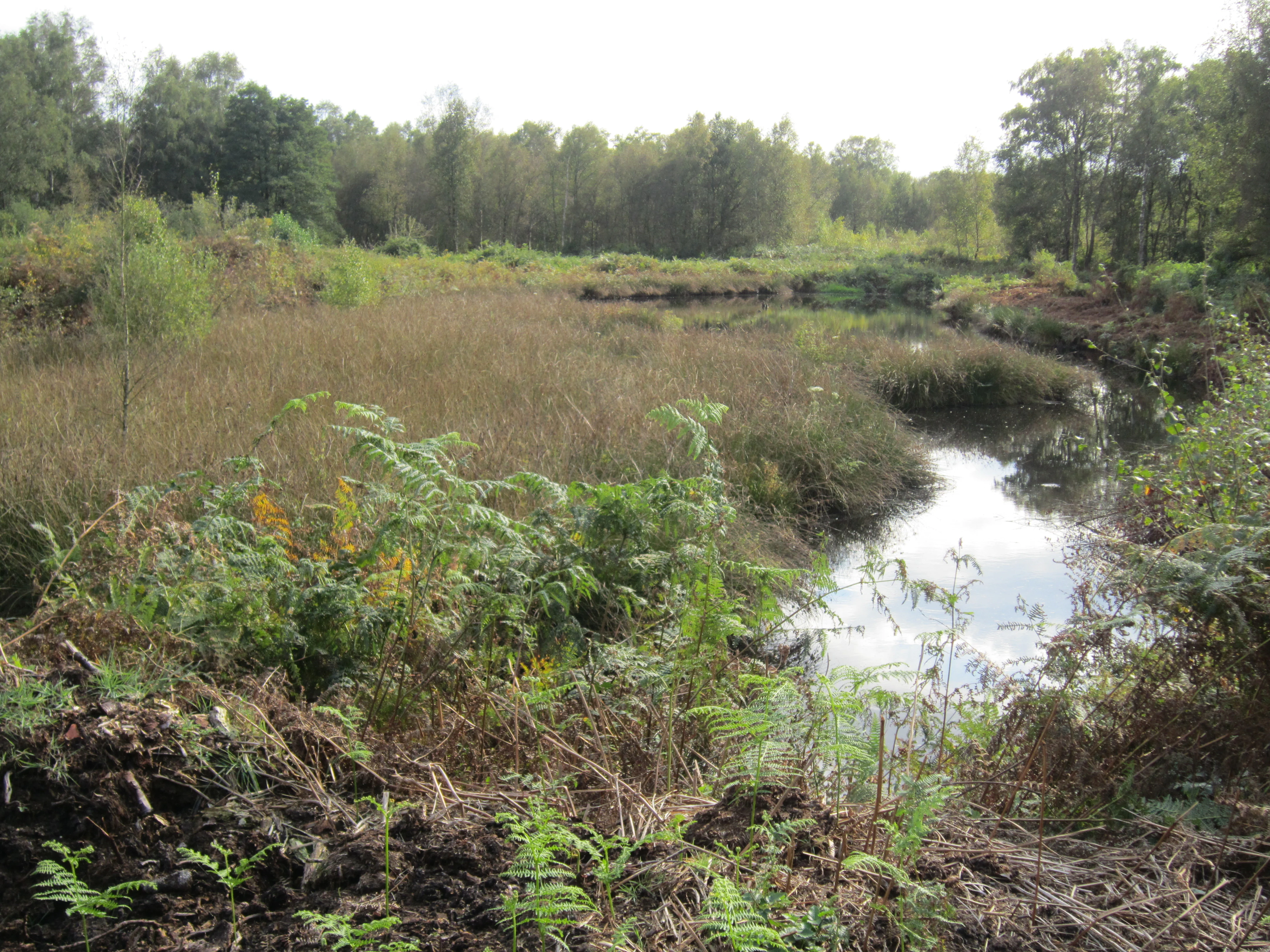
A channel of dark water flowing through a marshy bog area surrounded by low vegetation and a forest backdrop.
A view of the wetland and stream environment within the Steinfelder Moor nature reserve.

Steinfelder Moor history and protected-area timeline

Steinfelder Moor has a long history of human use tied to the peat economy of the Diepholz region. Like much of the surrounding Diepholzer Moorniederung, its peat soils were once worked for fuel and horticultural peat, leaving behind a mosaic of cut surfaces, relic ditches, and altered vegetation patterns. The present nature reserve is one of several twentieth-century conservation efforts aimed at preserving what remained of the historic Großes Moor between Vechta and Diepholz.

The reserve was formally established on August 2, 1986, when the responsible authorities of Lower Saxony designated the area as Naturschutzgebiet Steinfelder Moor, assigning it the official identifier NSG WE 175. Since then, the site has been administered under the oversight of the Landkreis Vechta as the lower nature protection authority, with the NLWKN acting as the state's technical agency for water management, coastal protection, and nature conservation.

In the decades since designation, management has increasingly emphasized the rewetting of former peat-cut sections, reflecting a broader shift in German peatland conservation away from purely protective measures and toward active hydrological restoration. The reserve today sits within a wider web of protected peatland sites, reflecting the gradual recognition of the regional importance of these fragmented bog landscapes. In 2009, the discovery of poisoned raptors in both Steinfelder Moor and the neighboring Diepholzer Moor underscored the continuing ecological pressures facing even small, formally protected bog reserves in the region.

Steinfelder Moor landscape and geographic character

Steinfelder Moor occupies a remarkably flat stretch of the Diepholzer Moorniederung, where elevations shift only a few meters across the entire reserve, ranging from about 37 to 43 meters above sea level. The terrain is shaped almost entirely by peat-forming processes, with deep organic soils built up over millennia of slow plant accumulation in a cool, wet, nutrient-poor environment. The result is a subdued, open landscape whose drama lies less in elevation than in subtle shifts among bog, woodland, and meadow.

The physical setting is interspersed with the traces of historical peat extraction. Formerly worked surfaces now appear as slightly depressed, waterlogged basins, which are gradually refilling as rewetting restores conditions favorable to Sphagnum and other bog plants. Ditches cut through the surface, connecting the reserve to the regional canal system and ultimately to the Hunte river. Together, these features create a mosaic of regenerating open bog, established bog woodland, and peripheral grassland, giving the protected area its distinctive internal geography.

Beyond the reserve's borders, the wider landscape continues the same peatland-influenced character. The neighboring Diepholzer Moor to the east, the Südlohner Moor to the north, and the protected Haverbeker Moor landscape to the south extend the bog environment in all directions, framing Steinfelder Moor as a central node within a larger, historically continuous moorland region that has only been partially preserved through formal protection.

Steinfelder Moor ecosystems, habitats, and plant life

The ecological identity of Steinfelder Moor rests on its status as a raised bog, a rare and threatened habitat type across Germany. Raised bogs are ombrotrophic systems, fed almost exclusively by rain and atmospheric inputs, and they depend on persistent saturation to maintain their characteristic vegetation and peat-forming processes. Steinfelder Moor captures this ecological signature despite its modest size, offering a representative example of northwest German bog ecosystems within an otherwise heavily cultivated lowland matrix.

A defining feature of the reserve is the extensive cover of bog woodland that has developed across much of the area. Where peat cutting, drainage, or disturbance shifted conditions away from open bog, stunted pines, birches, willows, and other moisture-tolerant species have established, forming a low, hardy canopy over a moist peat floor. In contrast, the actively managed rewetting zones and the margins of the reserve support more open vegetation, including peat mosses and other specialized bog flora. Around the perimeter, slightly drier mineral-influenced soils allow patches of grassland to persist, acting as an interface between bog and the surrounding agricultural countryside.

Hydrology is the central organizing force in this ecosystem. The reserve's ditches, the Mittlerer Hochmoorkanal, and the Haverbeker Moorgraben together determine how much water remains in the peat system. By moderating drainage and initiating rewetting, management aims to reactivate peat growth and improve habitat quality for bog-dependent species. In ecological terms, Steinfelder Moor thus exemplifies the modern challenge of restoring functional bog processes on a small, fragmented site embedded within a densely modified regional landscape.

Steinfelder Moor wildlife and species highlights

The wildlife profile of Steinfelder Moor is shaped by its peatland character and by the surrounding lowland farmland of the Diepholz region. The reserve offers habitat for bird species typical of raised bogs and their margins, including ground-nesting and perching species that favor open bog woodland, wet peat surfaces, and transitional habitats between bog and grassland. Raptors have been documented hunting over the area, and the 2009 incidents in which poisoned birds of prey were discovered in both Steinfelder Moor and the neighboring Diepholzer Moor highlight the reserve's significance for raptor populations in this part of Lower Saxony.

Beyond birds, the wet, acidic, nutrient-poor conditions typical of the site support a specialized bog fauna adapted to peatland environments. Invertebrate communities associated with Sphagnum mires, damp bog woodland, and rewetted former peat cuts contribute to the broader biodiversity of the reserve, while the grassland margins and adjacent ditches provide additional foraging and dispersal habitat. The integration of Steinfelder Moor with the Diepholzer Moor and Südlohner Moor enlarges the effective wildlife domain for species that move across the remaining peatland network.

Steinfelder Moor conservation status and protection priorities

Steinfelder Moor holds a clear conservation role as one of the formally protected fragments of the once-extensive raised bogs of the Diepholzer Moorniederung. Classified under IUCN Category IV as a Habitat/Species Management Area, its purpose is not only to safeguard individual bog species but to maintain the ecological structure and function of the peatland system itself. Within the regional conservation framework of Lower Saxony, the reserve, identified as NSG WE 175, is part of a connected chain of peatland protected areas stretching across the Landkreis Vechta.

Conservation management focuses strongly on hydrology. By regulating ditch networks, supporting rewetting of former peat-cut areas, and coordinating water flows into the broader Hunte catchment, managers work to stabilize peat soils and encourage the return of peat-forming vegetation. These efforts link Steinfelder Moor to wider European peatland conservation priorities that emphasize active restoration, carbon storage in peat, and protection of rare bog habitats.

The reserve is also recognized as a component of the state's ecological network, with the NLWKN maintaining the formal designation and the Landkreis Vechta acting as the responsible lower nature protection authority. Its significance is reinforced by ongoing concerns over the wider moor landscape, including incidents such as the deliberate poisoning of raptors documented in 2009, which have drawn attention to the persistent threats facing even formally protected bog environments in this agricultural region.

Steinfelder Moor cultural meaning and human context

Steinfelder Moor is embedded in the cultural landscape of the Oldenburger Münsterland, a region of northwest Germany with a long tradition of settlement, agriculture, and small-scale peat use. Communities such as Steinfeld, Lohne, and Diepholz have historically interacted with the surrounding bogs through peat cutting and grazing of marginal land, and the surviving bog fragments, like Steinfelder Moor, are tangible reminders of that intertwined natural and cultural history.

The reserve is locally documented in regional publications such as the Jahrbuch für das Oldenburger Münsterland, which has featured scholarly articles on its natural and cultural significance. As in many parts of the Diepholzer Moorniederung, the present-day bog reserve reflects an evolving relationship between communities and landscape: from a working peatland, through a phase when many similar sites were lost to drainage and cultivation, to a protected ecological asset that now anchors regional identity and environmental awareness.

Top sights and standout views in Steinfelder Moor

Steinfelder Moor stands out as a compact but ecologically precise example of a northwestern German raised bog reserve, where bog woodland, regenerated peat-cut zones, and grassland margins come together on a single site. Its position at the heart of the Großes Moor between Vechta and Diepholz makes it a natural anchor point in the larger Diepholz peatland network, connected to neighboring nature reserves and protected landscapes.

The reserve is also notable for its active hydrological management, including deliberate rewetting of formerly exploited peat surfaces and integration into a regional drainage system that ultimately feeds the Hunte. Its long-standing formal protection since 1986, combined with documented conservation challenges such as raptor poisoning incidents, gives it both a stable administrative identity and a continuing place in regional conservation debates.

Best time to visit Steinfelder Moor

The character of Steinfelder Moor shifts subtly with the seasons in ways typical of open lowland peatland reserves in northwestern Germany. Late spring and early summer are particularly rewarding for experiencing the contrast between developing bog woodland, fresh green grassland margins, and rising water levels in the rewetted sections, which together emphasize the wet, open nature of the reserve.

Autumn brings cooler, damper conditions and can intensify the muted colors of the bog landscape, while winter, with frozen peat surfaces and low vegetation cover, offers the clearest sense of the flatness of the terrain and the visibility of the ditch and canal network. At any time of year, the muted, overcast weather typical of the region can itself be part of the experience, reinforcing the quiet, water-dominated character of the protected area.

Monthly climate preview

Track monthly temperature ranges and precipitation patterns across the protected terrain

Steinfelder Moor Climate Normals, Long-Term Temperature and Precipitation Rhythm

Representative coordinate records show average temperatures ranging from 1.08 degrees Celsius to 18.35 degrees Celsius alongside monthly precipitation between 1.37 and 2.34 millimeters per day. Examining the complete twelve-month profile reveals full annual temperature swings and precipitation averages across the protected landscape.
Annual mean9 °C
1 °C18 °C
Jan
Feb
Mar
Apr
May13°
Jun16°
Jul18°
Aug18°
Sep14°
Oct10°
Nov
Dec
Warmest month
July

18.4 °C

Coolest month
January

1.1 °C

Wettest month
December

2.3 mm/day

Driest month
April

1.4 mm/day

Park location guide

Geography guide, regional context, and park location map for Steinfelder Moor

Steinfelder Moor park geography, regions, and map view in Germany

Understand where Steinfelder Moor sits in Germany through a broader geographic reading of the surrounding landscape, nearby location context, and its mapped position within the national park landscape.

How Steinfelder Moor fits into Germany

Germany is a federal republic in Western and Central Europe with a population of over 83 million across sixteen constituent states. It is Europe's largest economy by nominal GDP and a major global exporter and importer. The capital is Berlin, and the country borders Denmark, Poland, Czech Republic, Austria, Switzerland, France, Luxembourg, Belgium, and the Netherlands.

Wider geography shaping Steinfelder Moor in Germany

Germany is located in Western and Central Europe, spanning 357,022 km². It borders Denmark to the north, Poland and the Czech Republic to the east, Austria and Switzerland to the south, and France, Luxembourg, Belgium, and the Netherlands to the west. The country has coastlines on the Baltic Sea and North Sea to the north, with the Alps located in the southern region.

Map view of Steinfelder Moor

Use this park location map to pinpoint Steinfelder Moor in Germany, understand its exact geographic position, and read its mapped placement within the surrounding landscape more clearly.

Pigeon | © OpenStreetMap contributors

Location context for Steinfelder Moor

Lower SaxonyVechta District

Visualizing peatland habitats and raised bog terrain in Lower Saxony

Steinfelder Moor Landscape and Scenery Photos

Examine detailed photographs documenting the flat terrain, bog woodland, and regenerating peatland environments across Steinfelder Moor. Visual records capture the distinctive character of protected wetland habitats and regional conservation zones.

A channel of dark water flowing through a marshy bog area surrounded by low vegetation and a forest backdrop.

Park atlas

Compare adjacent peatland reserves and connected regional moorland geography

Explore Other Parks Near Steinfelder Moor and Surrounding Protected Landscapes

Visitors exploring Steinfelder Moor can browse adjacent nature reserves and neighboring peatland habitats across the surrounding lowland region. Comparing these connected protected areas reveals the broader ecological continuity of northwestern German raised bogs.
Nature reserveNiedersachsen
About 5.2 km away#1 closest

Southeast

Westliche Dümmerniederung Nature Reserve: Regional Geography and Wetland Atlas

Protected marshlands and peatland landscapes in Niedersachsen

Spanning roughly 996 hectares within the districts of Vechta and Diepholz, Westliche Dümmerniederung represents a significant wetland complex in northwestern Germany. The reserve consists of wet pastures, hay meadows, and alder carr forests, forming a coherent part of the Dümmer basin protected landscape. This atlas record provides context on the physical boundaries and ecological composition of this vital lowland terrain.

Area
9.96 km²
Established
1952
IUCN
IV
Nature reserveLandkreis Osnabrück
About 12 km away#2 closest

South

Westliche Dümmerniederung im Landkreis Osnabrück: Protected Wetland Landscape and Map

Extensive wet grassland and fen reserve in Lower Saxony

Covering roughly 490 hectares, the Westliche Dümmerniederung im Landkreis Osnabrück stands as one of the largest contiguous wet grassland complexes in northwestern Germany. The reserve features a dense pattern of drainage ditches, reedbeds, and rewetted meadows that sustain critical populations of breeding waders and migratory birds. Its flat, open terrain offers a clear look at the historic lowland fen geography characteristic of the Dümmer basin region.

Area
4.9 km²
Established
2023
Relief
Lowland
Climate
Temperate
Nature reserveLower Saxony
About 16 km away#3 closest

South

Streithorst Nature Reserve: Alluvial Woodland and River Lowlands in Lower Saxony

Protected floodplain forest and riparian geography

Located in the Osnabrück district, Streithorst functions as a vital nature reserve representing the rare ash and elm alluvial forests of the Hunte valley. This site, originating from a historic manor park, offers a concentrated look at riparian stream dynamics and mature woodland habitats surrounded by the agricultural plains of Lower Saxony.

Area
0.069 km²
Established
1982
IUCN
IV
Nature reserveLandkreis Osnabrück
About 19 km away#4 closest

South

Venner Moor Nature Reserve: Geography and Peatland Conservation in Landkreis Osnabrück

A legacy of industrial peat mining and wetland restoration

Venner Moor preserves a diverse peatland ecosystem featuring distinct zones of birch woodland and open, industrially scarred terrain. This protected area in Landkreis Osnabrück serves as a primary example of mire renaturation, where infrastructure like old railway lines illustrates the historical human imprint on the German landscape.

Area
2.18 km²
Established
1992
IUCN
IV
A wide watercolor illustration showing a misty landscape with soft purple mountains in the distance and pink and green grasses in the foreground against a white background.
Nature reserveGermany
About 32 km away#5 closest

East

Steinbrinker-Ströhener Masch: Nature Reserve and Wetland Protected Area in Lower Saxony

Mapping the fen peat grasslands and moorland buffers of Germany.

Steinbrinker-Ströhener Masch is an essential protected site in northwestern Germany, characterized by low-lying fen peat soils and expansive wet grasslands. Functioning as a key link within the Diepholzer Moorniederung, the area preserves critical habitat for meadow-breeding birds, shaped by seasonal waterlogging and traditional low-intensity land management techniques.

Area
3.25 km²
Established
1991
Relief
Lowland
Climate
Temperate
Nature reserveBavaria
About 32 km away#6 closest

South

Steinernes Meer Nature Reserve: Protected Glacial Boulder Landscapes and Geological Terrain

Geological heritage and forest terrain in the Osnabrück district

Steinernes Meer Nature Reserve covers a dense cluster of large glacial erratic boulders known as findlings. These massive stones, left by retreating ice sheets, create a striking, stony forest floor that defines the reserve as a significant geological landmark within the broader regional landscape.

Area
0.127 km²
Established
1937
Relief
Upland
Climate
Temperate
Watercolor painting of a rolling forested landscape with hills in the background and a gentle valley floor in the foreground, rendered in soft green and earth tones.
Nature reserveNorth Rhine-Westphalia
About 38 km away#7 closest

South

Limberg und Offelter Berg: Exploring Protected Forest Landscapes in North Rhine-Westphalia

Nature reserve geography and Wiehen Hills woodland terrain

Limberg und Offelter Berg is a foundational nature reserve in eastern Westphalia, known for its well-preserved beech forest mosaic and the protected headwaters of the Landwehrbach. Positioned on the eastern ridge of the Wiehen Hills, the area features a varied terrain of forested slopes and small valleys. It remains a critical study area for native woodland communities, reflecting eight decades of continuous landscape protection in the Minden-Lübbecke district.

Area
1.861 km²
Established
1935
Relief
Upland
Scope
Terrestrial
Nature reserveLandkreis Osnabrück
About 39 km away#8 closest

West

Suddenmoor Nature Reserve: Mapped Protected Landscapes in Landkreis Osnabrück

Lowland peatland habitats and regional German geography

Suddenmoor serves as a crucial nature reserve in Landkreis Osnabrück, characterized by its flat, peat-rich soil and dense network of drainage channels. The reserve preserves an authentic Artland landscape, featuring a rare combination of wet meadow ecosystems and traditional Wallhecken field boundaries. This protected area stands as a vital connector between larger wetland complexes in the northern German lowland terrain.

Area
3.11 km²
Established
2018
Relief
Lowland
Climate
Temperate

Common questions about visiting, size, designation, and location context for Steinfelder Moor

Steinfelder Moor FAQs for park facts, access, geography, and protected area context

Find quick answers about Steinfelder Moor, including protected-area facts, park geography, trail and visitor context, and how the park fits into its surrounding country and regional landscape.
MoriAtlas Explorer

Continue Your Protected Areas Search Across the Global Atlas

Deepen your exploration by continuing the structured search for national parks and protected areas worldwide. Utilize the comprehensive filtering capabilities to compare different conservation landscapes and refine your understanding of global park geography. Discover more about the distribution and characteristics of protected natural areas.

Global natural geography