

Mori Atlas logo
Nature reserveStenumer Holz

A study of continuous oak-beech forest mosaic, alluvial stream corridors, and traditional geest terrain

Stenumer Holz Nature Reserve and Protected Ancient Woodland Landscape in Lower Saxony, Germany

Stenumer Holz represents a significant ancient broadleaf forest site located within the gently undulating terrain of the Wildeshauser Geest in Lower Saxony. This protected nature reserve encompasses 96 hectares of near-natural oak-hornbeam and beech woodlands, featuring complex alluvial forest communities along two slow-moving stream corridors. The reserve serves as a vital ecological corridor, showcasing long-term forest continuity and a traditional landscape structure that remains a key component of the regional geography in northwestern Germany.

ancient forestoak-beech woodlandnature reserveNatura 2000Lower SaxonyWildeshauser Geest

Stenumer Holz

Nature reserve

Park overview

Structured park overview, official facts, and landscape profile for Stenumer Holz

Stenumer Holz park facts, protected area profile, and essential visitor context

Review the core facts for Stenumer Holz, including designation, size, terrain, visitor scale, habitats, and operating context in one park-focused overview.

About Stenumer Holz

Stenumer Holz is a small, predominantly broadleaf woodland in the municipality of Ganderkesee, just north of the village of Stenum and within the Oldenburg district of Lower Saxony. Although modest in size at roughly 96 hectares, it is a high-quality example of the ancient forest sites that characterise the Wildeshauser Geest, a sandy upland region between Bremen and the Weser Marsh whose surviving old woods are treated as especially valuable for nature conservation in northwestern Germany.

The reserve was formally designated as a nature reserve on 15 December 2018 under the designation NSG WE 311 and overlaps almost exactly with a same-named Fauna-Flora-Habitat (FFH) site of about 94 hectares, placing it within the European Natura 2000 ecological network. A previous landscapes protection area (Landschaftsschutzgebiet) of the same name was absorbed into the stricter nature reserve regime when the new ordinance came into force.

Ecologically, Stenumer Holz protects a near-natural forest mosaic rather than a single, uniform woodland type. Oak-hornbeam forests on moist soils and Luzula beech forests on drier, more acidic sites share the canopy, while narrow strips of alluvial forest follow the two small streams that cross the area. A formerly cultivated wet meadow that has fallen fallow is enclosed within the reserve on three sides. The woodland carries a substantial share of old and dead wood, an important structural feature for specialist insects, fungi, and cavity-nesting birds, and the northwestern forest edge has been shaped into a traditional 'Wallhecke' hedge-bank line.

Although it is a strictly protected area, Stenumer Holz remains closely tied to its surrounding villages of Stenum, Schierbrok, and Rethorn. A public road crosses its western edge, multiple forest and walking paths run through the canopy, and a forest education trail brings visitors into contact with the woodland. Local kindergartens and the Grundschule Schierbrok operate a 'Waldklassenzimmer' (forest classroom) in the area, using the reserve as an outdoor learning site. Together, these features make the wood simultaneously a conservation priority, a Natura 2000 site, and a nearby everyday green space for the surrounding communities.

Quick facts and research context for Stenumer Holz

Stenumer Holz is a roughly 96 hectare nature reserve (NSG WE 311) in the municipality of Ganderkesee, Oldenburg district, Lower Saxony. It lies on the northwestern edge of the Naturpark Wildeshauser Geest and is essentially coincident with a same-named FFH Natura 2000 site of about 94 hectares. The reserve was designated on 15 December 2018 and protects an ancient forest site of near-natural oak and beech woodland, with small alluvial forests along two streams and an enclosed abandoned wet meadow.

Protection and recognition

Documented protection history and official Natura 2000 recognition records

Stenumer Holz Protection Status and International Recognition Data

Stenumer Holz maintains a terrestrial protection status established in 2018 alongside documented Natura 2000 recognition sources. Official conservation designations and administrative records provide structured insight into the managed landscape history.

International recognition

Protection details

Protection scope
Terrestrial
Designated year
2018
Transboundary protection
No
Park context

Deeper park guide and search-rich context for Stenumer Holz

Stenumer Holz history, landscape, wildlife, and travel context

Explore Stenumer Holz through its history, landscape character, ecosystems, wildlife, conservation priorities, cultural context, and seasonal travel timing in a structured park guide built for atlas discovery and search intent.

Why Stenumer Holz stands out

Stenumer Holz is best known as a small but ecologically valuable ancient broadleaf forest in the northwestern German geest landscape. Its defining character is the combination of oak-hornbeam forests on moist sites, Luzula beech forests, narrow alluvial gallery forests along two small streams, and a high proportion of old and dead wood. The wood represents one of the traditional 'Hude' or grazing-forest landscapes of the Wildeshauser Geest and still carries the structural marks of long, continuous forest cover.
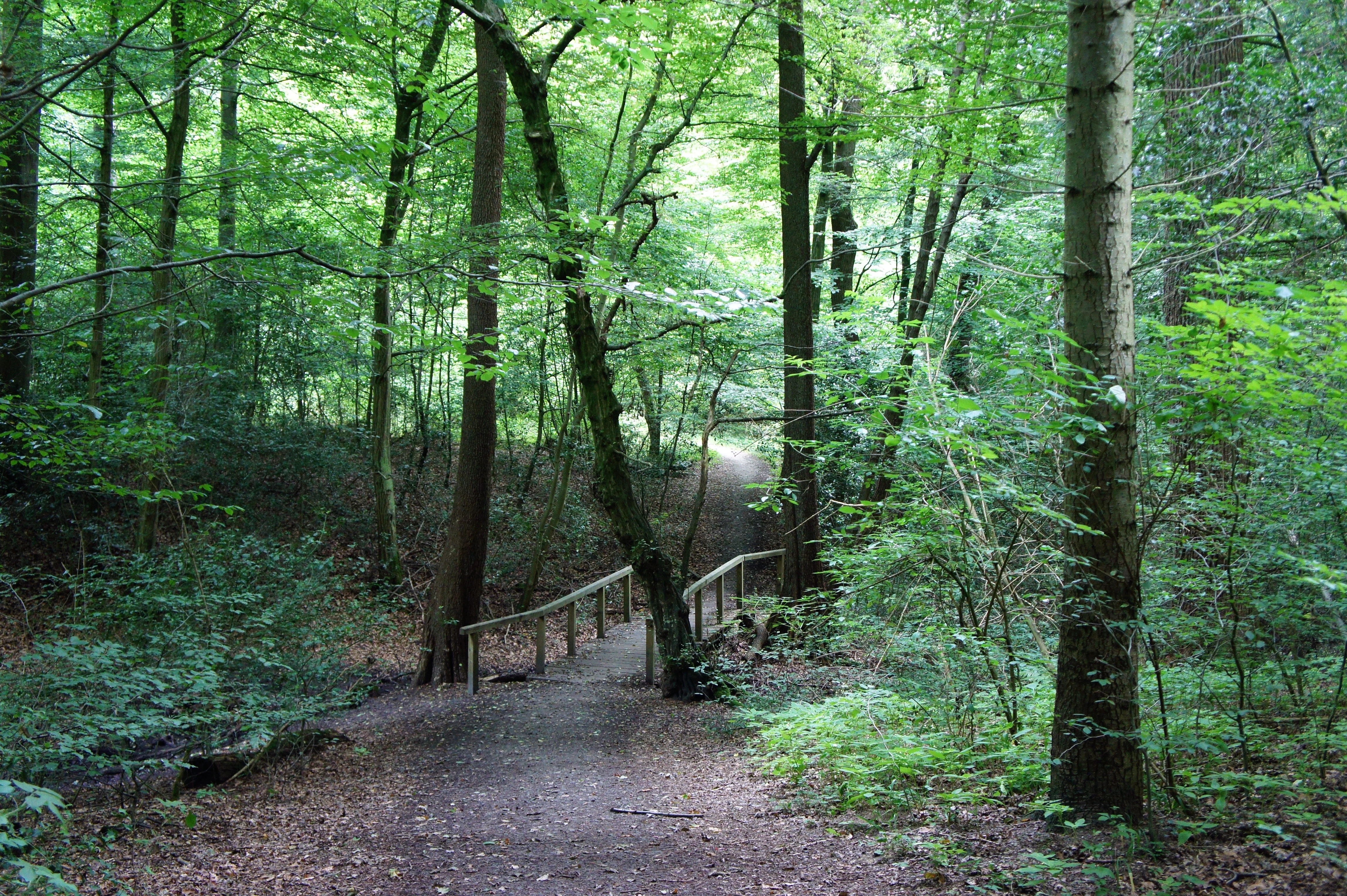
A dirt hiking trail leads through a lush, green deciduous forest, passing over a simple wooden footbridge in the center of the frame.
A shaded hiking trail crosses a small wooden bridge within the dense woodland of Stenumer Holz.

Stenumer Holz history and protected-area timeline

Stenumer Holz has functioned as woodland for a very long time and is treated as a historically old forest stand ('historisch alter Waldstandort'), a category that in northwestern German conservation refers to sites with continuous forest cover going back centuries, often shaped by former grazing-forest or 'Hude' use.

A landscape protection area of the same name existed for many years as the principal protective designation, surrounding what is now the core zone. This landscape protection area was incorporated into the new nature reserve ordinance once the site was upgraded. The reserve itself was formally established on 15 December 2018 under the code NSG WE 311, marking the moment when the site gained full nature reserve status under the Lower Saxon nature conservation framework. With that designation, the local district of Oldenburg became the responsible lower nature conservation authority.

The 2018 designation also aligned the site with European conservation policy: the protected woodland is described as essentially coincident with a Fauna-Flora-Habitat area of about 94 hectares, embedding Stenumer Holz in the Natura 2000 network. Two natural monuments ('Naturdenkmäler') lie inside the reserve: a group of erratic boulders known as the 'Grabfindlinge im Stenumer Holz' (ND 213) and the 'Dicke Eiche Stenum' (ND 212), a notably large pedunculate oak that serves both as a natural monument and as a local landmark.

Stenumer Holz landscape and geographic character

Stenumer Holz occupies a gently undulating portion of the Wildeshauser Geest, a sandy upland in northwestern Lower Saxony whose surface lies only modestly above sea level, in this case between roughly 7 and 32 metres in elevation. The terrain rises and falls in low, almost imperceptible steps, crossed by two small, slow stream courses that have shaped narrow alluvial corridors.

In form, the area is a contiguous but texturally varied forest rather than a uniform stand. Dry ridges carry beech-dominated woodland, moister hollows carry oak-hornbeam forest, and the small stream valleys support thin strips of softwood alluvial forest dominated by black alder and ash. On the northwestern side, the forest edge runs along a 'Wallhecke', a traditional hedge-bank line that combines a low earthen bank with planted shrubs and is one of the characteristic small landscape features of the northwestern German countryside.

Embedded within this woodland on its eastern side is a flat, formerly cultivated wet meadow now lying fallow, surrounded on three sides by forest. The combination of closed canopy, open wet ground, and stream corridors gives the small reserve a surprising amount of internal structural variety. Although it is bordered by roads and the settlements of Rethorn, Schierbrok, and Stenum, the woodland itself reads as a continuous expanse from within.

Stenumer Holz ecosystems, habitats, and plant life

Despite its compact size, Stenumer Holz contains a clearly layered mosaic of woodland habitats typical of the northwestern German geest. The dominant forest types are oak-hornbeam forest on moist, loamier sites and Luzula beech forest on drier, more acidic soils, both characteristic of long-established broadleaf forest in this part of Lower Saxony.

In the moister oak-hornbeam stands, pedunculate oak and hornbeam share the canopy, accompanied by European beech, while the shrub layer includes holly, spindle, hazel, and hawthorn. The herb layer is rich in classical woodland indicators such as wood anemone, enchanter's nightshade, hedge woundwort, and greater stitchwort, together with woodland grasses and sedges, ivy, and wood sorrel. The beech-dominated stands are structurally simpler, with beech and oak in the canopy, abundant holly in the shrub layer, and a ground flora featuring wavy hair-grass, lesser woodrush, bracken, and male fern.

Along the two small streams, narrow alluvial forests of black alder and ash have developed, interspersed with bird cherry, spindle, and red currant, and a ground flora adapted to moving, slightly calcareous water, including meadowsweet, bittercress, opposite-leaved and alternate-leaved golden saxifrage, giant fescue, marsh marigold, and tall meadow foxtail. Conifers, primarily spruce, pine, larch, and Douglas fir, are present as a non-dominant component, reflecting more recent forestry history. Throughout the reserve, forest structure is unusually continuous: there is a high share of old trees and standing and fallen dead wood, an important substrate for saproxylic insects, fungi, and cavity-nesting vertebrates.

Stenumer Holz wildlife and species highlights

The woodland character of Stenumer Holz is most clearly reflected in its bird community. The reserve is identified as habitat for several species of woodpecker, which depend on the abundant old and dead wood, and it also supports typical year-round and breeding woodland birds such as Eurasian nuthatch, Eurasian jay, common starling, and common chaffinch. The high proportion of mature broadleaf trees and decaying wood is the single most important wildlife feature of the site.

Stenumer Holz conservation status and protection priorities

Stenumer Holz is a formally protected nature reserve under Lower Saxon law and simultaneously part of the European Natura 2000 network through its designation as a Fauna-Flora-Habitat site. Its conservation value rests on three linked pillars: continuity of forest cover, habitat diversity, and structural maturity.

The reserve sits on a historically ancient forest site, meaning that woodland here has persisted without being completely cleared for agriculture, which is rare in the densely settled northwestern German countryside. This continuity supports woodland species that struggle to colonise younger forest. Habitat diversity is provided by the mosaic of oak-hornbeam forests, beech forests, alluvial forests, and the enclosed wet meadow, while structural maturity is expressed in the unusually high share of old trees and dead wood. Two natural monuments within the reserve, the erratic boulder group and the monumental pedunculate oak 'Dicke Eiche Stenum', are themselves individually protected features. Together, these qualities make Stenumer Holz a compact but disproportionately rich reference site for ancient oak and beech woodland conservation in the Oldenburg region.

Top sights and standout views in Stenumer Holz

A compact ancient forest reserve with rare continuity of broadleaf cover in the Wildeshauser Geest; an oak-hornbeam and beech mosaic enriched by alluvial forest along two streams; a high share of old and dead wood of strong value for specialist woodland species; a Natura 2000 FFH site of almost identical extent; and a working forest classroom and recreation area for the surrounding villages of Stenum, Schierbrok, and Rethorn.

Monthly climate preview

Long-term representative measurements of temperature and precipitation rhythms across the protected landscape

Stenumer Holz Climate Normals and Annual Weather by Month

Stenumer Holz records annual climate measurements detailing long-term average temperature variations and monthly precipitation patterns from representative coordinates. Reviewing the complete twelve-month normals profile provides deeper analytical insight into regional meteorological conditions.
Annual mean9 °C
1 °C18 °C
Jan
Feb
Mar
Apr
May13°
Jun16°
Jul18°
Aug18°
Sep14°
Oct10°
Nov
Dec
Warmest month
July

18 °C

Coolest month
January

1 °C

Wettest month
July

2.5 mm/day

Driest month
April

1.4 mm/day

Park location guide

Geography guide, regional context, and park location map for Stenumer Holz

Stenumer Holz park geography, regions, and map view in Germany

Understand where Stenumer Holz sits in Germany through a broader geographic reading of the surrounding landscape, nearby location context, and its mapped position within the national park landscape.

How Stenumer Holz fits into Germany

Germany is a federal republic in Western and Central Europe with a population of over 83 million across sixteen constituent states. It is Europe's largest economy by nominal GDP and a major global exporter and importer. The capital is Berlin, and the country borders Denmark, Poland, Czech Republic, Austria, Switzerland, France, Luxembourg, Belgium, and the Netherlands.

Wider geography shaping Stenumer Holz in Germany

Germany is located in Western and Central Europe, spanning 357,022 km². It borders Denmark to the north, Poland and the Czech Republic to the east, Austria and Switzerland to the south, and France, Luxembourg, Belgium, and the Netherlands to the west. The country has coastlines on the Baltic Sea and North Sea to the north, with the Alps located in the southern region.

Map view of Stenumer Holz

Use this park location map to pinpoint Stenumer Holz in Germany, understand its exact geographic position, and read its mapped placement within the surrounding landscape more clearly.

Pigeon | © OpenStreetMap contributors

Location context for Stenumer Holz

Lower Saxony
Recorded earthquake history

Explore Recorded Earthquake History for the Stenumer Holz Nature Reserve

Examine the historical record of seismic events associated by location with Stenumer Holz. This MoriAtlas catalogue provides event dates, magnitudes, and depth measurements to support your geographic research into the seismic context of this Lower Saxony forest site.

Stenumer Holz Earthquake History

Catalogued events

1 event

Strongest magnitude

Magnitude 4

Most recent event

Jul 15, 2005

This history includes earthquakes recorded inside the park or within 50 km of its borders

Explore detailed imagery of ancient oak woodlands, stream valleys, and protected habitats.

Stenumer Holz Photos and Landscape Scenery: Visualizing the Ancient Forest Sanctuary

Visual documentation captures the varied terrain, sandy geest ridges, and alluvial corridors defining the ancient broadleaf canopy of Stenumer Holz. Photographic records reveal structural habitat details, including moist beech-oak mosaics and quiet wetland meadows within the protected reserve.

A dirt hiking trail leads through a lush, green deciduous forest, passing over a simple wooden footbridge in the center of the frame.

Park atlas

Compare regional woodland reserves and connected conservation areas in northwestern Germany

Explore Parks Near Stenumer Holz and Surrounding Protected Landscapes

Browse other parks near Stenumer Holz to examine similar ancient broadleaf woodlands and sandy geest terrain across the region. Continuing the comparison reveals broader ecological patterns and connected protected landscapes throughout northwestern Germany.
Nature reserveOldenburg
8.4 km away#1 closest

Southwest

Stühe Nature Reserve: A Detailed Map and Geographic Overview of the Delmenhorster Geest

Protected beech forests and lowland bog ecosystems in Oldenburg

Stühe serves as a significant forest refuge in the Oldenburg district, showcasing a rare intersection of beech, oak, and riparian floodplain forests. This nature reserve, anchored within the wider Delmenhorster Geest landscape, features glacial depressions, kettle-like stillwaters, and preserved bog monuments that document the natural history of the northwest German lowlands.

Area
2.17 km²
Established
2018
Relief
Lowland
Climate
Temperate
Nature reserveBremen
About 10 km away#2 closest

East

Ochtumniederung bei Brokhuchting: Wetland Nature Reserve and Floodplain Geography

A core conservation area within the Bremen Niedervieland

This protected area stands as a primary example of large-scale river floodplain restoration in the Bremen region. The landscape includes a dense network of canals, reedbeds, and seasonal flood zones that provide critical shelter for waterfowl and waders. Through careful environmental management, this site integrates natural riverine terrain with the surrounding industrial and urban framework of northwestern Germany, offering a distinct study of managed wetland ecosystems.

Area
3.75 km²
Established
1998
Relief
Lowland
Climate
Temperate
A watercolor painting showing a soft, panoramic view of a flat wetland area with green trees, a solitary tree in the middle, and industrial silos faintly visible in the background.
Nature reserveBremen
About 11 km away#3 closest

East

Hochwasserschutzpolder zwischen Senator-Apelt-Straße und Neustädter Hafen: Bremen Protected Lands

A vital wetland reserve integrating flood management and avian biodiversity in the port district.

Located within the port district of Bremen, the Hochwasserschutzpolder zwischen Senator-Apelt-Straße und Neustädter Hafen is a notable protected area that balances essential flood-control infrastructure with rich ecological functions. The reserve sustains a variety of wetland bird populations across its reed-lined waters and alluvial woodlands, providing a critical haven for wildlife amidst the surrounding industrial and urban development of the Lower Weser region.

Area
0.847 km²
Established
2014
IUCN
IV
Nature reserveBremen
About 11 km away#4 closest

Northeast

Dunger See Nature Reserve: Mapped Protected Wetland and Landscape Geography in Bremen

A structured geographic look at the Werderland bird protection habitat.

Dunger See is a compact, ecologically diverse nature reserve in Bremen, shaped by intentional land management to provide critical nesting and wintering grounds for wildfowl. This protected area stands out for its indented shoreline, artificial island clusters, and surrounding woodland buffers that contrast with the open agricultural terrain of the wider Werderland landscape.

Area
0.33 km²
Established
1990
Relief
Lowland
Climate
Temperate
Nature reserveBremen
About 13 km away#5 closest

North

Hammersbecker Wiesen: Protected Nature Reserve and Meadow Landscape in Bremen

Ecological mosaic of wet meadows and stream valley terrain

Hammersbecker Wiesen encompasses 25.8 hectares of ecologically significant wet grassland and hedgerow habitats in Bremen. This nature reserve provides an essential refuge for diverse plant species and local amphibians within an urban-adjacent setting, illustrating the preserved character of traditional northern German meadow systems.

Area
0.258 km²
Established
1986
A horizontal watercolor painting showing a tranquil lake scene with green trees, low-lying hills in the distance, and grassy banks against a white background.
Nature reserveBremen
13 km away#6 closest

Northeast

Grambker Feldmarksee Nature Reserve: Mapping the Protected Landscapes of Bremen

A vital wetland sanctuary shaped by regional infrastructure and natural restoration

Grambker Feldmarksee offers a focused look at how post-industrial quarry sites evolve into ecologically dense nature reserves. This groundwater-fed lake in Bremen acts as a green island, showcasing mature woodland fringes and specialized wetland habitats that are integral to the local bird protection network.

Area
0.226 km²
Established
2009
Relief
Lowland
Climate
Temperate
A horizontal watercolor painting depicting a soft-focus landscape with a pond in the foreground, pink and green heath vegetation, and distant tree lines under a pale sky.
Nature reserveBremen
About 13 km away#7 closest

North

Eispohl, Sandwehen und Heideweiher: Protected Landscape and Geest Geography

Nature reserve featuring historic dunes and heath pond networks

This nature reserve in Bremen protects a remnant of the Rekumer Geest, featuring a complex of inland dunes, wet heath, and small heath ponds. Through its combination of extensively grazed grasslands and mixed forests, the area serves as a vital habitat corridor, maintaining the traditional Geest landscape patterns that once dominated the region between Bremen and the lower Weser.

Area
0.036 km²
Established
1988
Relief
Lowland
Climate
Temperate
Nature reserveBremen
About 14 km away#8 closest

Northeast

Ruschdahlmoor Nature Reserve: Deep Peatlands and Protected Wetland Geography in Bremen

Geological subsidence sinkhole and urban protected landscape

Ruschdahlmoor stands as a unique nature reserve in Bremen, Germany, distinguished by a peat-forming wetland developed inside a sinkhole over the Lesum salt dome. This protected area supports tall herb meadows, reed-fringed ponds, and rare peat-depth records, offering a dense, ecologically rich landscape context that remains a vital part of the city's natural geography.

Area
0.048 km²
Established
1991
IUCN
IV
Relief
Lowland

Common questions about visiting, size, designation, and location context for Stenumer Holz

Stenumer Holz FAQs for park facts, access, geography, and protected area context

Find quick answers about Stenumer Holz, including protected-area facts, park geography, trail and visitor context, and how the park fits into its surrounding country and regional landscape.
MoriAtlas Explorer

Continue Your Protected Areas Search Across the Global Atlas

Deepen your exploration by continuing the structured search for national parks and protected areas worldwide. Utilize the comprehensive filtering capabilities to compare different conservation landscapes and refine your understanding of global park geography. Discover more about the distribution and characteristics of protected natural areas.

Global natural geography


