
Mori Atlas logo
Nature reserveStoffelskuppe

A textbook basalt Härtling formation featuring rare scree forest ecosystems and ancient volcanic block fields.

Stoffelskuppe Nature Reserve: Volcanic Geology and Protected Primeval Forest Landscapes in Thuringia

Stoffelskuppe represents a distinct volcanic landmark on the northeastern fringe of the Rhön in Thuringia, Germany. Rising as a prominent basalt cap above softer sandstone, this protected nature reserve preserves an area of near-primeval dry and scree forest that has remained undisturbed for decades. The rugged southern slopes contain expansive basalt block fields, providing essential micro-habitats for diverse mosses, lichens, and small fauna in a landscape shaped by geological erosion.

volcanic hillbasalt geologyHärtling landformscree forestold-growth forestnature reserve
A flat vector illustration showing a mountainous valley landscape with two waterfalls, a river, dense forests, and a rocky talus field in the foreground under a sunny sky.

Stoffelskuppe

Nature reserve

Park overview

Structured park overview, official facts, and landscape profile for Stoffelskuppe

Stoffelskuppe park facts, protected area profile, and essential visitor context

Review the core facts for Stoffelskuppe, including designation, size, terrain, visitor scale, habitats, and operating context in one park-focused overview.

About Stoffelskuppe

Stoffelskuppe is a small but ecologically rich hill set on the northeastern edge of the Rhön uplands in central Germany. Although modest in height at roughly 620 meters, it occupies a special place in the regional landscape because it combines two contrasting natural elements, iron-hard volcanic basalt and softer Triassic sandstone, in a single compact landform. The basalt cap that crowns the summit has resisted erosion far better than the sandstone beneath and around it, leaving the hill standing above the surrounding Werra hill country as a classic Härtling, a residual landform preserved by its resistant summit rock.

The hill lies within or directly adjacent to the Rhön Biosphere Reserve, one of Germany's recognized model regions for sustainable development and nature protection. While the Stoffelskuppe itself has been protected since the early 1960s, its surroundings have since accumulated further layers of designation, including a landscape protection area covering much of the Thuringian Rhön, a Natura 2000 Fauna-Flora-Habitat zone that joins the hill with its neighbor Pleß and the nearby Bernshäuser Kutte sinks, and a European bird protection area. Together these designations knit the hill into a much broader network of conservation areas across the Rhön.

For visitors, Stoffelskuppe is less a major destination than a quiet walking hill embedded in a deeply protected rural landscape. It is crossed by the Hochrhöner, a long-distance trail that links the most scenic ridges and summits of the Rhön over more than 170 kilometers, and is encircled by shorter circular routes such as the Rhön-Rundweg Urnshausen. From the summit, open ground offers views across the valleys and forested ridges of the northern Rhön, but the hill's main appeal lies below the treeline, in the natural block fields and old-growth forest that are the reason it is protected at all.

Quick facts and research context for Stoffelskuppe

Stoffelskuppe lies near the village of Roßdorf in the Schmalkalden-Meiningen district of Thuringia, on the northeastern edge of the Rhön mountain region. The hill reaches roughly 620 meters above sea level and is formed from a basalt plug that protects underlying Triassic sandstone from erosion, classifying it geologically as a Härtling, or residual hill.

The summit and southern slopes have been a designated nature reserve since 1961, and the hill is also covered by parts of a larger landscape protection area, a Natura 2000 Fauna-Flora-Habitat site, and a bird protection area, all linked to the broader Rhön Biosphere Reserve. Its old-growth dry and scree forests and natural basalt block fields are recognized as important habitats for rare mosses, lichens, and small mammals rather than as a visitor-heavy attraction.

Protection and recognition

Documented terrestrial protection history and conservation framework data

Stoffelskuppe Protection Status and Protected Area Designation Record

Stoffelskuppe maintains a recorded terrestrial protection status established in 1961 within official conservation databases. Structured records assemble historical designation timelines and management scope parameters for comprehensive geographical analysis.

Protection details

Protection scope
Terrestrial
Designated year
1961
Transboundary protection
No
WDPA ID
165752
Park context

Deeper park guide and search-rich context for Stoffelskuppe

Stoffelskuppe history, landscape, wildlife, and travel context

Explore Stoffelskuppe through its history, landscape character, ecosystems, wildlife, conservation priorities, cultural context, and seasonal travel timing in a structured park guide built for atlas discovery and search intent.

Why Stoffelskuppe stands out

Stoffelskuppe is best known for its old-growth, largely unmanaged dry and scree forests that have developed on and around its basalt block fields, creating a near-primeval woodland in the heart of the Rhön. The natural basalt talus on the south slope in particular is valued by conservationists as a habitat for rare lichens, mosses such as the woolly haircap moss, and small fauna including pygmy shrews. Equally distinctive is the hill's geological character: a hard basalt cap, the remnant of an ancient volcanic eruption, has acted as a protective shield over softer sandstone, producing a textbook Härtling landform. This combination of volcanic geology and protected woodland is the hill's defining ecological signature.
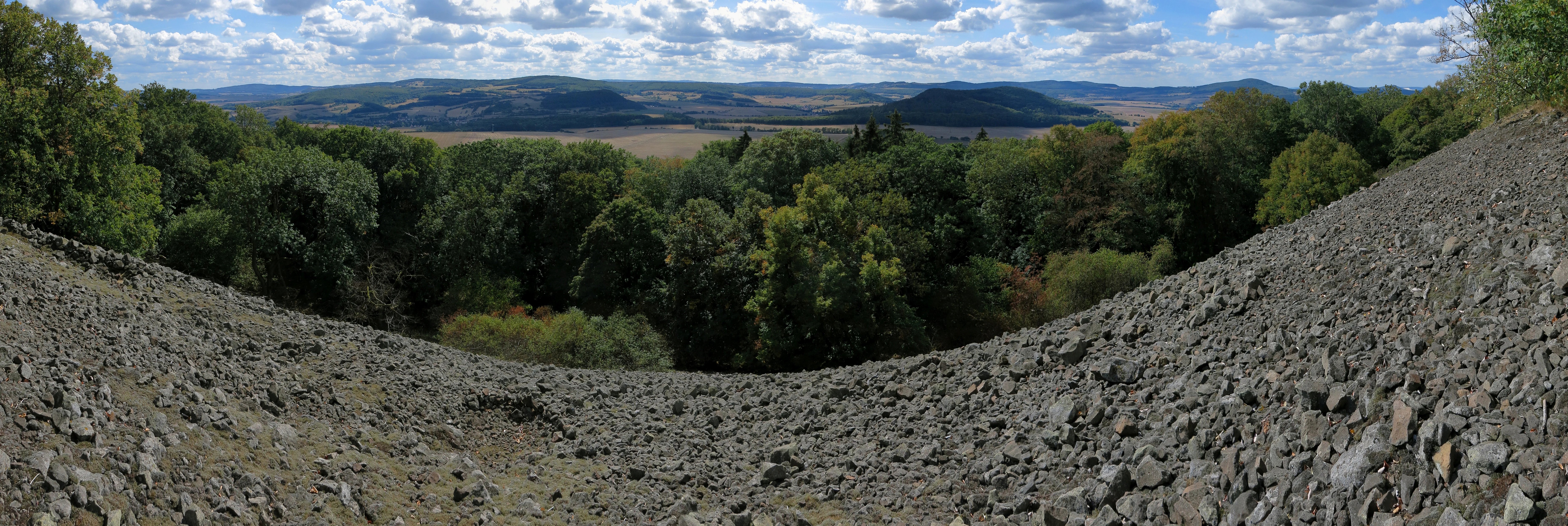
A wide panoramic photograph showing a rocky basalt talus slope in the foreground leading down to a dense forest canopy and distant rolling hills under a blue sky with scattered clouds.
A panoramic view looking out over the talus slopes of the Stoffelskuppe toward the Rhon region.

Stoffelskuppe history and protected-area timeline

The administrative history of Stoffelskuppe as a protected area began in 1961, when the summit region and the upper parts of its southern slope were formally designated as a nature reserve under Thuringian conservation law. The reserve was created in recognition of the unusually well-preserved dry and scree woodland that had developed on the basalt block fields of the hill, woodland that, having been taken out of forestry use, was beginning to take on a near-primeval character.

Over the following decades the hill's conservation status was reinforced through additional overlapping designations. In 1989, the surrounding slopes became part of the large Thuringian Rhön landscape protection area, extending coordinated landscape-scale protection across a much wider territory. With the growth of European conservation networking, the hill was incorporated into a Natura 2000 Fauna-Flora-Habitat site named Pleß-Stoffelskuppe-Bernshäuser Kutte, linking it with the neighboring Pleß summit and the sinkhole lake of Bernshäuser Kutte at its western foot, while the European bird protection area Thüringische Rhön added habitat protection for nesting and migratory bird species across the broader landscape.

The long-term outcome of these layered protections is a hill whose forests have been allowed to age without significant forestry intervention, encouraged by the original 1961 reserve and reinforced by the later European-level designations. While the hill itself is small, its history illustrates how a locally protected site in central Germany has become part of a continent-wide conservation framework.

Stoffelskuppe landscape and geographic character

Stoffelskuppe forms a compact, rounded summit rising about 620 meters above sea level from a broader belt of forested ridges and valleys. In topographical terms it is a textbook Härtling, a landform preserved by its hard cap: the basalt that crowns the hill has shielded the softer sandstone below from the same erosional forces that have worn down the surrounding Werra hill country, leaving the Stoffelskuppe as a locally prominent peak on the northeastern fringe of the Rhön.

The southern face of the hill is shaped by a natural basalt block field, where angular blocks of volcanic rock have accumulated over millennia. This talus forms a rugged, stony apron below the summit and partially overlays the sandstone of the deeper subsurface. Forestry has been excluded from much of this terrain, and as a result the block slopes are now interwoven with old, gnarled trees and accumulations of fallen timber, giving the south side a distinctly wild, almost primeval appearance in contrast to the more managed agricultural land at the hill's edges.

Beyond the immediate hill, the wider setting is one of mixed agricultural land, occasional villages, and forested ridges that step gently down toward the Werra river valley. To the west, near the village of Bernshausen, the landscape dips into the sinkhole lake known as Bernshäuser Kutte, while the neighboring Pleß summit rises to the northeast. From the open high ground of Stoffelskuppe, the broader northern Rhön landscape unfolds in a sequence of wooded ridges and open valleys, particularly visible on clear days.

Stoffelskuppe ecosystems, habitats, and plant life

Ecologically, Stoffelskuppe is defined less by dramatic elevation than by the quality and continuity of its forest cover and the unusual habitats created by its volcanic geology. The slopes carry species-rich dry woodland and scree forest that, free from active forestry management for decades, have evolved into structurally diverse stands with old trees, standing and fallen deadwood, and a developing understory of mosses, lichens, and shade-tolerant shrubs.

The basalt block fields on the southern slope are the hill's most ecologically distinctive habitat. The cool, humid microclimate beneath and between the blocks supports communities of mosses and lichens that are rare in Germany as a whole, including populations of the woolly haircap moss, recognized by its long silvery glass hairs and classified as very rare nationally. The same shelters and crevices that protect these lower plants also shelter small ground-dwelling fauna, with pygmy shrews recorded moving across the boulder surfaces.

Surrounding the core hill, the landscape broadens into a mosaic of agricultural fields, meadows, and forest fragments that are themselves partly within the Thuringian Rhön landscape protection area. The combination of intense local protection on the summit and broader landscape-scale protection on its flanks gives the hill an ecological role that exceeds its modest size, functioning as a small but stable core within an extensive connected habitat network in the central Rhön.

Stoffelskuppe wildlife and species highlights

Stoffelskuppe is not a high-profile wildlife destination, and its fauna is generally that of a central European mid-elevation hill. The hill's most frequently highlighted wildlife association is with very small ground-dwelling mammals and the rich lower-plant communities that support them. Pygmy shrews are noted as moving across the basalt boulders of the southern block fields, taking advantage of the cool, sheltered microclimate between the stones.

The varied structure of the old-growth woodland, with standing and fallen deadwood, old trees, and dense moss cover, provides habitat for forest-interior bird species and the typical range of woodland invertebrates associated with undisturbed deciduous and mixed forest in the Rhön. Because the hill also lies within a European bird protection area that extends across the wider Thuringian Rhön, it sits within a landscape managed for nesting and migratory species at a regional scale, although the Stoffelskuppe itself is most often emphasized for its botanical and microhabitat values rather than for charismatic large fauna.

Overall, the hill's wildlife character is one of quiet ecological richness, with rare mosses and lichens, small mammals, and typical Rhön woodland fauna collectively giving the protected area its main wildlife significance rather than a single emblematic species.

Stoffelskuppe conservation status and protection priorities

Stoffelskuppe's conservation significance lies in the combination of long-standing legal protection and the unusual quality of the habitats that protection has preserved. Designated as a nature reserve in 1961, the hill was recognized early for the species-rich dry and scree forests on its slopes, forests that have since matured into quasi-primeval stands because active forestry use was halted and has not been resumed.

The hill is classified internationally at the highest practical level of habitat and species management, reflecting its role in conserving older forest structures, rare mosses and lichens, and the small mammals associated with the basalt block fields. The surrounding landscape is covered by the large Thuringian Rhön landscape protection area, while the hill itself is part of the Natura 2000 Fauna-Flora-Habitat site Pleß-Stoffelskuppe-Bernshäuser Kutte and the broader Thüringische Rhön bird protection area, embedding it in both national and European ecological networks.

Taken together, these layers of protection give Stoffelskuppe a conservation role far larger than its 22-hectare core reserve would suggest. It functions as a small but strictly protected nucleus within the much larger Rhön Biosphere Reserve, contributing old-growth forest habitat and rare rock-dwelling species to a landscape-level conservation strategy for central Germany.

Stoffelskuppe cultural meaning and human context

Stoffelskuppe sits within a rural agricultural and forestry landscape that has long been shaped by small Thuringian villages such as Roßdorf, Bernshausen, Rosa, and Urnshausen set along the lower slopes and valleys of the northeastern Rhön. The hill itself has no prominent built monuments or traditions attached to it, and its cultural significance is primarily that of a shared local landmark and walking ground rather than a site of folklore or major heritage events.

The hill today is tied into the regional hiking culture of the Rhön, being crossed by the Hochrhöner long-distance trail and by shorter circular routes that link it to the villages at its foot. In this sense, Stoffelskuppe is part of the everyday outdoor and rural identity of the area, valued by local residents for views, walks, and a sense of the protected natural character of the surrounding Rhön landscape, rather than for any single cultural landmark.

Top sights and standout views in Stoffelskuppe

The standout features of Stoffelskuppe are its old-growth dry and scree forests, its natural basalt block fields, and its layered conservation status. The hill offers near-primeval woodland on a volcanic summit, rare mosses and lichens in the cool crevices of basalt boulders, and small ground-dwelling mammals such as pygmy shrews living among the rocks, all within a compact site protected since 1961.

Equally notable is the hill's setting on the northeastern fringe of the Rhön, embedded in the Rhön Biosphere Reserve and crossed by the Hochrhöner long-distance trail, with sweeping views across the forested ridges and open valleys of the northern Rhön from its summit. The combination of unusual volcanic geology, undisturbed woodland, and integration into regional and European conservation networks makes Stoffelskuppe a quietly significant landmark in the central German uplands.

Best time to visit Stoffelskuppe

Stoffelskuppe can be visited year-round, but the character of a visit changes meaningfully with the seasons. Late spring and early summer bring fresh green foliage and active birdlife in the surrounding forests, while autumn is arguably the most atmospheric period, when the mixed deciduous canopy turns color and views from the more open parts of the summit are at their clearest against cooler, often clearer skies.

In winter the hill can be quieter and more reflective, with frost and occasional snow emphasizing the rugged texture of the basalt block fields on the southern slope, though paths may be slippery and conditions on higher tracks can be more demanding. Because the hill sits within a strongly protected landscape, visitors generally approach it on foot via the established local and long-distance trails rather than by vehicle, and a low-impact approach on marked paths helps preserve the very habitats that make the area worth visiting.


Monthly climate preview

Measured annual temperature and monthly precipitation averages for Stoffelskuppe in Thuringia

Stoffelskuppe Climate Normals and Long-Term Weather by Month

Stoffelskuppe records long-term average monthly temperatures spanning sub-zero winter minimums to warm summer maximums alongside steady daily precipitation patterns. Reviewing the complete monthly climate dataset provides deeper context on multi-year meteorological norms across the terrain.
Annual mean8 °C
-2 °C18 °C
Jan-2°
Feb-1°
Mar
Apr
May12°
Jun16°
Jul18°
Aug18°
Sep13°
Oct
Nov
Dec-1°
Warmest month
July

18 °C

Coolest month
January

-1.6 °C

Wettest month
July

2.6 mm/day

Driest month
April

1.5 mm/day

Park location guide

Geography guide, regional context, and park location map for Stoffelskuppe

Stoffelskuppe park geography, regions, and map view in Germany

Understand where Stoffelskuppe sits in Germany through a broader geographic reading of the surrounding landscape, nearby location context, and its mapped position within the national park landscape.

How Stoffelskuppe fits into Germany

Germany is a federal republic in Western and Central Europe with a population of over 83 million across sixteen constituent states. It is Europe's largest economy by nominal GDP and a major global exporter and importer. The capital is Berlin, and the country borders Denmark, Poland, Czech Republic, Austria, Switzerland, France, Luxembourg, Belgium, and the Netherlands.

Wider geography shaping Stoffelskuppe in Germany

Germany is located in Western and Central Europe, spanning 357,022 km². It borders Denmark to the north, Poland and the Czech Republic to the east, Austria and Switzerland to the south, and France, Luxembourg, Belgium, and the Netherlands to the west. The country has coastlines on the Baltic Sea and North Sea to the north, with the Alps located in the southern region.

Map view of Stoffelskuppe

Use this park location map to pinpoint Stoffelskuppe in Germany, understand its exact geographic position, and read its mapped placement within the surrounding landscape more clearly.

Pigeon | © OpenStreetMap contributors

Location context for Stoffelskuppe

Thuringia

Examine protected woodland habitats, volcanic summits, and rugged block fields in Thuringia.

Stoffelskuppe Photos and Landscapes: Visual Guide to Basalt Geology and Scree Forests

Visual documentation captures the old-growth scree forests and basalt talus slopes defining the protected landscapes of Stoffelskuppe. Photographic records reveal the complex volcanic terrain and rare habitats preserved across the northern Vordere Rhön uplands.

A wide panoramic photograph showing a rocky basalt talus slope in the foreground leading down to a dense forest canopy and distant rolling hills under a blue sky with scattered clouds.

A distant, forested hill under a clear blue sky, with a wooden raised hunting platform built into a tree in the foreground.

Park atlas

Compare nearby volcanic peaks and connected protected landscapes across the region.

Parks Near Stoffelskuppe and Surrounding Protected Areas

Browse nearby national parks and protected areas sharing the volcanic geography of Stoffelskuppe. Comparing adjacent reserves reveals the broader ecological patterns and forested upland terrain of the surrounding region.
A horizontal watercolor illustration showing a calm lake in the distance with soft, green, hilly horizons and painted leaves framing the foreground.
Nature reserveThuringia
About 1.3 km away#1 closest

West

Bernshäuser Kutte: A Protected Sinkhole Lake and Geological Landmark in Thuringia

Mapped nature reserve, karst terrain, and salt subsidence geotope.

Bernshäuser Kutte represents a significant protected area known for its near-circular basin and dramatic depth. This geological feature is embedded within the forest landscape of the Thuringian Rhön, serving as a well-documented site for understanding karst processes, water stratification, and long-term conservation in central Germany.

Area
0.131 km²
Established
1942
IUCN
IV
Nature reserveThuringia
About 3.5 km away#2 closest

North

Werra bis Treffurt mit Zuflüssen: Protected River and Floodplain Network in Thuringia

Mapping an extensive 191 kilometer Natura 2000 river corridor.

The Werra bis Treffurt mit Zuflüssen protected area serves as a vital ecological corridor in Thuringia. This site encompasses a complex mosaic of fast-flowing highland brooks, expansive floodplain meadows, inland salt sites, and rare dissolution lakes. Its geography bridges high-altitude source regions with lower river valleys, creating a distinctive landscape transect that supports essential freshwater habitats and rare aquatic species across the state.

Area
22.6 km²
Established
2008
IUCN
IV
Relief
Mixed relief
Nature reserveThuringia
About 6.9 km away#3 closest

Southwest

Ibengarten Nature Reserve: Protected Yew Forest Landscape in the Thuringian Rhön

A historic protected area preserving rare ancient yew stands in central Germany.

Ibengarten encompasses a 56-hectare reserve in Thuringia, recognized for its dense concentration of wild European yew trees. This unique woodland environment, set against the basalt ridges of the Rhön, provides an essential look at historical conservation efforts and old-growth forest dynamics in the German low mountains.

Area
0.561 km²
Established
1938
IUCN
IV
Nature reserveThuringia
About 7.7 km away#4 closest

North

Werra-Aue zwischen Breitungen und Creuzburg: Protected Floodplain and River Geography

Nature reserve sanctuary in western Thuringia

Spanning over 33 kilometers of the Werra river, this protected floodplain is defined by its distinctive geological sinkholes, seasonal wetlands, and diverse bird habitats. Discover the layered conservation status and riparian terrain that mark this significant Thuringian nature reserve as a crucial node for European ecological connectivity.

Area
25.78 km²
Established
2007
IUCN
IV
Relief
Lowland
Nature reserveWartburgkreis
About 9.8 km away#5 closest

North

Erlensee - Maiwiesen Nature Reserve and Werra Floodplain Protected Landscape

A vital wetland and meadow network in Wartburgkreis, Germany

Erlensee - Maiwiesen represents an important nature reserve in the Wartburgkreis district of Germany, characterized by the pairing of an alder-fringed lake with extensive wet meadows. This area plays a significant role in the regional Werra biotope network, focusing on the preservation of riverine habitats and lowland grassland biodiversity within a settled landscape. The site serves as a prime example of active habitat management and floodplain connectivity.

Area
1.089 km²
Established
2018
IUCN
IV
Nature reserveWartburgkreis
About 13 km away#6 closest

Northwest

Brühl von Merkers Nature Reserve: Floodplain Geography in the Wartburgkreis District

Protected Werra valley meadows and wetland ecosystems

Brühl von Merkers preserves a rare, open stretch of Werra river floodplain within Germany. This nature reserve offers a detailed look at extensively managed grasslands and wetland habitats that support avian populations and maintain regional ecological integrity within the Wartburgkreis administrative area.

Area
1.756 km²
Established
2014
IUCN
IV
A soft watercolor illustration showing rolling hills, sparse forest clusters, and rocky foreground elements, set against a light background.
Nature reserveThuringia
About 16 km away#7 closest

Northwest

Öchsenberg Nature Reserve: Basaltic Peaks and Ancient Landscapes in the Thuringian Rhön

Geographic overview of a volcanic protected area

Öchsenberg stands as a characteristic basalt dome, shaped by ancient volcanic activity and defined by its distinct scree slopes and beech woodlands. This nature reserve, located in the northern Rhön foothills, offers a concentrated landscape where geological history meets the remnants of extensive Celtic fortifications overlooking the Werra valley.

Area
2.67 km²
Established
1990
Relief
Mountain
Climate
Temperate
Nature reserveHessen
About 21 km away#8 closest

Southwest

Naturschutzgebiet Westlicher Rhönwald: Protected Forest and Volcanic Geology in Hessen

Core biosphere zone and montane beech woodland reserve

Spanning 44 hectares of the Hessian Rhön, Naturschutzgebiet Westlicher Rhönwald functions as a strictly protected zone dedicated to natural forest succession. The reserve is characterized by a volcanic basalt cap over a shell limestone foundation, creating cool and moist soil conditions ideal for a diverse beech-rich canopy. It remains a focal point for understanding montane woodland development in the central European uplands.

Area
0.444 km²
Established
1997
IUCN
IV
Relief
Mountain

Common questions about visiting, size, designation, and location context for Stoffelskuppe

Stoffelskuppe FAQs for park facts, access, geography, and protected area context

Find quick answers about Stoffelskuppe, including protected-area facts, park geography, trail and visitor context, and how the park fits into its surrounding country and regional landscape.
MoriAtlas Explorer

Continue Your Protected Areas Search Across the Global Atlas

Deepen your exploration by continuing the structured search for national parks and protected areas worldwide. Utilize the comprehensive filtering capabilities to compare different conservation landscapes and refine your understanding of global park geography. Discover more about the distribution and characteristics of protected natural areas.

Global natural geography