Mori Atlas logo
Nature reserveStotts Island Nature Reserve

Analyzing the fluvial geography and ecological refuges of a vital river island habitat in the Tweed Valley.

Stotts Island Nature Reserve: Mapping the Protected Lowland Subtropical Rainforest Landscapes of New South Wales

Stotts Island Nature Reserve represents a critical protected landscape situated within the Tweed River of northern New South Wales. This fluvial landform serves as a primary refuge for lowland subtropical rainforest, offering a distinct contrast to the surrounding agricultural floodplains. By examining the island's alluvial deposits and shifting riverine boundaries, observers gain insight into the conservation of rare habitats and the unique environmental patterns defining this protected Australian terrain.

lowland subtropical rainforestriver islandrainforest reserveNorthern RiversTweed Rivercritical habitat

Stotts Island Nature Reserve

Nature reserve

Park overview

Structured park overview, official facts, and landscape profile for Stotts Island Nature Reserve

Stotts Island Nature Reserve park facts, protected area profile, and essential visitor context

Review the core facts for Stotts Island Nature Reserve, including designation, size, terrain, visitor scale, habitats, and operating context in one park-focused overview.

About Stotts Island Nature Reserve

Stotts Island Nature Reserve sits within the Tweed River floodplain, close to where the river widens and slows near the New South Wales and Queensland border. The reserve protects Stotts Island itself, a river island built up from successive layers of alluvium laid down from the Pleistocene to the present day. Because the river periodically overtops its banks, the island is in constant flux, accumulating fresh silt and organic material during floods while losing material elsewhere to erosion. This dynamic setting has shaped both the geology beneath the reserve and the way vegetation has accumulated on its surface.

Above that alluvial foundation, the reserve's defining feature is its lowland subtropical rainforest. Roughly 77 hectares of this forest type remain intact on the island, comprising a tall, multi-layered canopy dominated by characteristic east coast rainforest species. Hoop pine and bangalow palm emerge above a broader canopy that includes tuckeroo, red cedar, giant water gum, hard quandong, cigar cassia and white fig. The scale and height of this forest give the island a quieter, more enclosed atmosphere than the cleared farmland that surrounds much of the Tweed valley.

Ecologically, the reserve matters less for its absolute size than for what it represents in a regional context. The surrounding lowlands have been progressively converted to agriculture, sand mining and residential development, leaving relatively few substantial rainforest remnants. Stotts Island retains an unusually complete example of what the pre-clearing vegetation of the area may have looked like, and it serves as a reservoir for rainforest-dependent species whose habitat has contracted sharply elsewhere. The reserve's designation as critical habitat for Mitchell's rainforest snail underlines this refugial role, while its management under a strict nature reserve category reflects an intent to keep the rainforest largely undisturbed.

For visitors and researchers, the reserve offers a focused point of access into the broader Northern Rivers rainforest network, with the adjacent Bruce Chick Conservation Park extending restoration efforts onto the adjoining riverbank. Together, the island and its riverside buffer represent a small but coherent protected landscape within an otherwise heavily modified floodplain.

Quick facts and research context for Stotts Island Nature Reserve

Stotts Island Nature Reserve is a river island protected area in the Northern Rivers region of New South Wales, on the Tweed River just inland from Tweed Heads. It has been a formal nature reserve since 25 June 1971 and is managed by NSW National Parks and Wildlife Service under an IUCN Category Ia strict nature reserve designation.

The reserve covers around 141 hectares and contains approximately 77 hectares of intact lowland subtropical rainforest, the dominant feature of the island. The reserve is declared critical habitat for the endangered Mitchell's rainforest snail, and its rainforest includes a mix of native trees such as hoop pine, bangalow palm, red cedar, giant water gum, hard quandong, cigar cassia, tuckeroo and white fig.

Documented fauna includes around 47 bird species, several reptile and frog species, and mammals whose populations remain poorly known. Weeds such as madeira vine, cat's claw, moonflower and lantana threaten nearby rainforest fragments but have so far had limited impact on the island itself.

Protection and recognition

Terrestrial protected area classification, management scope, and recognition context

Stotts Island Nature Reserve Protection Status and International Recognition

Stotts Island Nature Reserve maintains a defined terrestrial protection scope within its documented conservation framework. Official records compile the verified legal designation history and international recognition criteria without additional status claims.

Protection details

Protection scope
Terrestrial
Transboundary protection
No
Park context

Deeper park guide and search-rich context for Stotts Island Nature Reserve

Stotts Island Nature Reserve history, landscape, wildlife, and travel context

Explore Stotts Island Nature Reserve through its history, landscape character, ecosystems, wildlife, conservation priorities, cultural context, and seasonal travel timing in a structured park guide built for atlas discovery and search intent.

Why Stotts Island Nature Reserve stands out

Stotts Island Nature Reserve is best known for protecting one of the last significant stands of lowland subtropical rainforest in the Tweed River valley, a vegetation type that has been almost entirely cleared from surrounding lowlands. The tall, structurally complex rainforest that dominates the island gives the reserve an unusually intact feel compared with nearby fragments, where agriculture, sand mining and development have thinned out much of the original canopy. The reserve also stands out for its role as declared critical habitat for the endangered Mitchell's rainforest snail, a species famously rediscovered in 1976 on the slopes of nearby Mount Wollumbin but whose survival in the lowlands depends heavily on refuges like Stotts Island. Together, these traits give the reserve an outsized conservation profile despite its modest size.
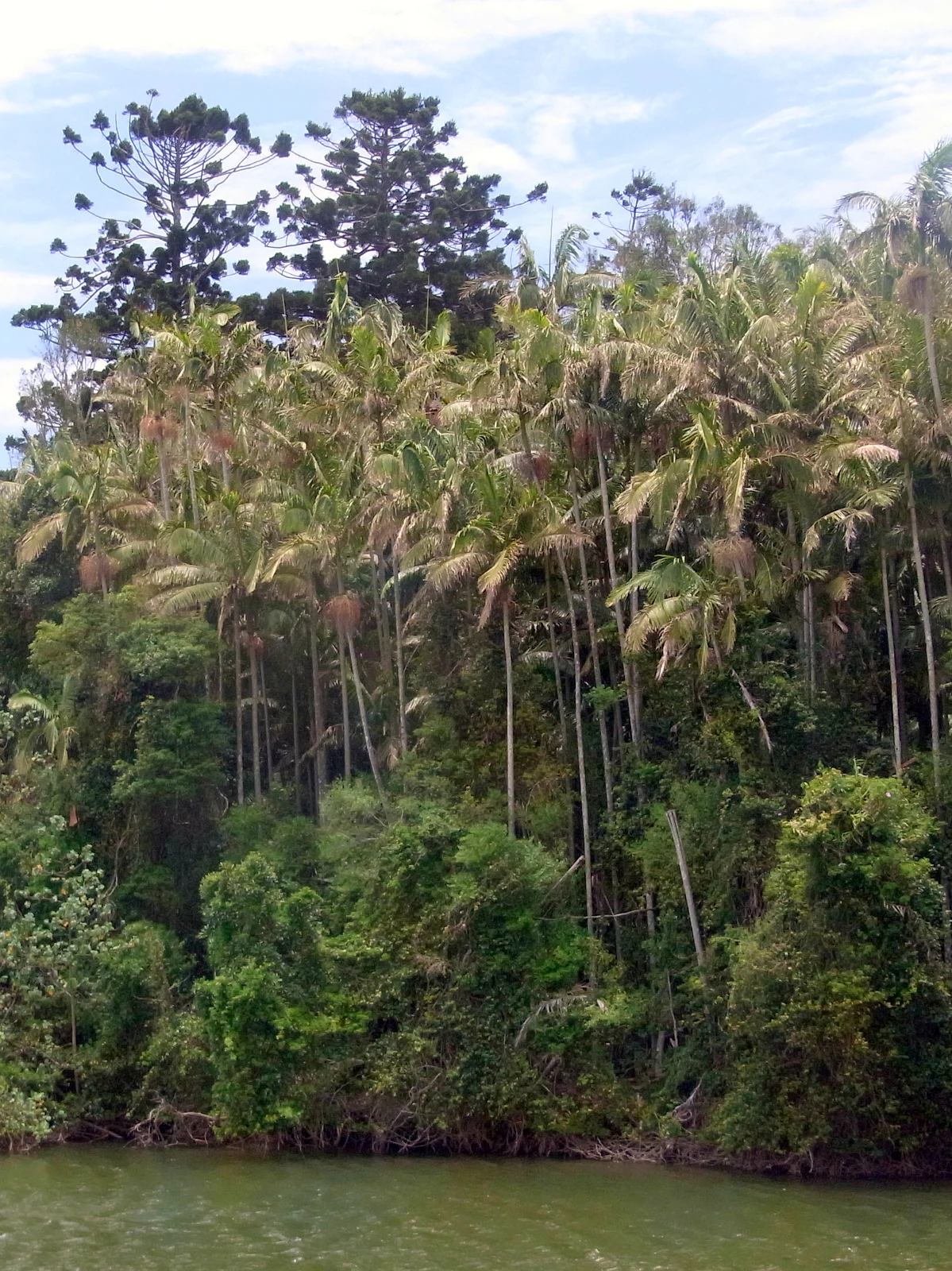
A dense stand of rainforest trees, including tall palm trees and conifers, growing along a riverbank.
Dense sub-tropical rainforest vegetation lining the banks of the Tweed River in Stotts Island Nature Reserve.

Stotts Island Nature Reserve history and protected-area timeline

Stotts Island takes its name from James Stott, an Irish convict who arrived in New South Wales in the nineteenth century. Originally sentenced in 1826 to seven years' transportation for the theft of clothing, Stott worked in the early colonial timber industry as a cedar cutter, a period in which the richly timbered lowlands of the Tweed valley were among the most actively exploited forests on the New South Wales coast. The island's nineteenth century association with cedar harvesting situates it within a wider history of forest exploitation that removed much of the region's most valuable timber.

The nature reserve itself was formally established on 25 June 1971, bringing the island under the protection of what is now NSW National Parks and Wildlife Service. Its designation reflects a broader shift in regional land management, as fragments of lowland rainforest that had survived the clearing era were increasingly recognised as irreplaceable. Subsequent decades brought growing attention to the island's role in supporting endangered fauna, particularly following the 1976 rediscovery of Mitchell's rainforest snail on nearby Mount Wollumbin, which highlighted the regional significance of surviving lowland rainforest stands such as the one on Stotts Island.

Alongside formal protection, local conservation efforts have shaped the reserve's modern character. The adjacent Bruce Chick Conservation Park, named after a local resident who encouraged revegetation of riverside rainforest, represents community-driven restoration work directly connected to the reserve's values. Together, government protection and grassroots revegetation efforts have framed Stotts Island as both a regulated refuge and a focal point for local ecological restoration in the lower Tweed valley.

Stotts Island Nature Reserve landscape and geographic character

Stotts Island is fundamentally a fluvial landform, a low-lying river island whose shape continues to change as the Tweed River moves around it. Its foundation consists of alluvium deposited over a long geological span from the Pleistocene through to the present, layering silt, sand and organic material in repeated flood cycles. This accumulated sediment is inherently unstable: floods regularly deposit fresh silt, driftwood and weed material across parts of the island, while currents simultaneously erode banks and edges elsewhere. The island is, in effect, an ongoing geological experiment in which vegetation and underlying sediments evolve together.

On top of this shifting substrate, the dominant surface feature is the rainforest canopy itself. Much of the island is cloaked in tall lowland subtropical rainforest that forms an almost continuous cover, broken only where small clearings, waterways or erosional edges interrupt the stand. Away from the river margins, the terrain is gently undulating rather than rugged, and the visual character of the island is shaped more by dense, layered forest than by dramatic relief.

The surrounding landscape reinforces this sense of a remnant within a cultivated plain. Beyond the island, the Tweed valley has been extensively cleared for agriculture and settlement, exposing the reserve's forest as a dark green outline against a sharper patchwork of pasture, cropping land and developed areas. The contrast between the island's forested interior and the openness of the surrounding floodplain is one of the reserve's most immediate landscape signatures, and it underscores how unrepresentative the island now is of the broader Tweed lowlands.

Stotts Island Nature Reserve ecosystems, habitats, and plant life

The ecological identity of Stotts Island Nature Reserve is built around a relatively intact block of lowland subtropical rainforest within an otherwise fragmented regional landscape. This forest type, once widespread along the moist coastal lowlands of northeastern New South Wales, has been heavily reduced by clearing for agriculture, sand mining, plantation forestry and housing. The remaining rainforest on Stotts Island stands out for its structural complexity and the height of its canopy, which produces a multi-layered habitat of emergents, mid-storey trees, palms and a dense understorey.

Rainforest tree composition includes characteristic east coast species such as hoop pine and bangalow palm in the upper layers, with tuckeroo, red cedar, giant water gum, hard quandong, cigar cassia and white fig contributing to canopy and subcanopy structure. The presence of red cedar is a reminder of the early colonial exploitation of the area, when this species was among the most sought-after timbers on the NSW coast. Wetland and riparian elements are interwoven with the forest, reflecting the island's alluvial substrate and its position within an active river system.

A persistent ecological concern is the integrity of the rainforest edge. Weeds such as madeira vine, cat's claw, moonflower and lantana have invaded nearby fragments and continue to pose the most serious threat to rainforest composition across the Tweed valley. On Stotts Island itself, these species have so far had limited impact, but their proximity means the reserve sits adjacent to a reservoir of potential invasion. Active revegetation work in the adjoining Bruce Chick Conservation Park, including plantings of the endangered red-fruited ebony, forms part of a broader effort to extend the island's rainforest values onto neighbouring land.

Stotts Island Nature Reserve wildlife and species highlights

Stotts Island Nature Reserve supports a rich assemblage of fauna for its size, although detailed inventories remain incomplete. Birdlife is the best-documented component: around forty-seven bird species have been recorded on the reserve, reflecting the diversity of habitat types packed into a relatively small area. The combination of tall rainforest canopy, dense understorey, river edge and levee environments produces niches for species reliant on intact forest structure as well as those that use the riparian interface.

Reptiles and amphibians are also represented, with six lizard species, three snake species and three frog species recorded to date. The presence of multiple frog species is meaningful in a region where rainforest-associated amphibians have been affected by habitat fragmentation and changing hydrology. As with many protected areas of this type, mammal populations are known to exist on and around the island but remain poorly catalogued, leaving an important gap in current knowledge of the reserve's fauna.

The reserve's highest-profile wildlife value is its role as declared critical habitat for Mitchell's rainforest snail, an endangered species whose survival in the lowlands depends on intact rainforest refuges. Although the snail is the headline species, the broader rainforest community, including dependent invertebrates, birdlife and herpetofauna, is what gives the reserve its ecological importance.

Stotts Island Nature Reserve conservation status and protection priorities

Conservation value is the central reason Stotts Island Nature Reserve is protected. The reserve holds one of the more significant remaining stands of lowland subtropical rainforest in the Tweed valley, a vegetation type that has been heavily cleared on the surrounding floodplain. By keeping this forest intact and buffering it within a strict nature reserve designation, the site safeguards habitat that is now exceedingly rare across the broader region.

The reserve's IUCN Category Ia (strict nature reserve) status reflects an intent to limit disturbance and keep the rainforest in as close to a natural state as possible. Its role as declared critical habitat for the endangered Mitchell's rainforest snail places it within a formal framework of species-specific protection, recognising the island's function as a refuge for a species whose lowland habitats have largely disappeared. This combination of habitat-level and species-level protection gives the reserve a conservation profile that is disproportionate to its size.

On a regional scale, the reserve is an anchor for rainforest persistence in a landscape otherwise shaped by clearing. The adjacent Bruce Chick Conservation Park extends the protected footprint onto the riverside margin, with active revegetation efforts, including plantings of the endangered red-fruited ebony, designed to reinforce the ecological values of the main reserve. Continued management focuses on monitoring weed incursions, particularly madeira vine, cat's claw, moonflower and lantana, which threaten nearby rainforest fragments and could eventually affect the island itself.

Stotts Island Nature Reserve cultural meaning and human context

The cultural significance of Stotts Island is grounded more in its colonial and community history than in formal heritage structures. The island's name commemorates James Stott, an Irish convict transported to New South Wales in 1826 and subsequently employed as a cedar cutter in the early colonial timber industry. Cedar cutting defined the early economic history of the Tweed valley and left a deep imprint on the region's forests, including the red cedar stands that still grow on Stotts Island today.

Local community identity is also reflected in the neighbouring Bruce Chick Conservation Park. Bruce Chick was a local resident who encouraged the revegetation of riverside rainforest around the reserve, and the park bearing his name preserves a tradition of grassroots conservation in the Northern Rivers. This community connection adds a modest but meaningful cultural layer to the reserve, framing it as both a regulated protected area and a place shaped by sustained local engagement with the landscape.

Top sights and standout views in Stotts Island Nature Reserve

Stotts Island Nature Reserve's standout feature is its 77-hectare block of intact lowland subtropical rainforest, which represents a notably complete example of a vegetation type that has been heavily cleared elsewhere in the Tweed valley. Tall hoop pine and bangalow palm rise above a diverse canopy of red cedar, giant water gum, hard quandong, cigar cassia, tuckeroo and white fig, producing one of the more visually impressive rainforest stands remaining in the region.

The reserve also stands out for its formal recognition as critical habitat for the endangered Mitchell's rainforest snail, and for the way it combines strict nature reserve protection with active restoration in the adjacent Bruce Chick Conservation Park. Together, these qualities make a small reserve a focal point for regional rainforest conservation.

Best time to visit Stotts Island Nature Reserve

Seasonal conditions on Stotts Island follow the broader Northern Rivers climate, with warm, humid summers and milder, drier winters. The rainforest character of the reserve is most lush through the warmer months of late spring and summer, when higher rainfall and humidity typically intensify the green density of the canopy, and when many rainforest-associated birds and frogs are most active.

Winter and early spring offer cooler, generally drier conditions that can make exploring lowland rainforest easier, although reduced foliage activity may make wildlife observation quieter. Because the reserve sits on a flood-prone river island, visitors should be aware that flooding can periodically reshape access conditions. Broadly, late spring through early autumn tends to highlight the rainforest at its most expressive, while cooler months offer a calmer, more subdued experience.

Monthly climate preview

Examine long-term representative temperature and precipitation patterns across the year

Stotts Island Nature Reserve Climate Normals and Average Temperatures

Stotts Island Nature Reserve exhibits a measured annual temperature range from cooler midyear readings to warmer summer averages, accompanied by varying monthly precipitation levels. Reviewing the complete twelve-month climate profile provides deeper insight into long-term environmental patterns recorded for this protected area.
Annual mean21 °C
18 °C25 °C
Jan25°
Feb25°
Mar24°
Apr23°
May21°
Jun19°
Jul18°
Aug18°
Sep20°
Oct21°
Nov22°
Dec24°
Warmest month
February

24.8 °C

Coolest month
July

17.8 °C

Wettest month
February

5.9 mm/day

Driest month
September

1.3 mm/day

Park location guide

Geography guide, regional context, and park location map for Stotts Island Nature Reserve

Stotts Island Nature Reserve park geography, regions, and map view in Australia

Understand where Stotts Island Nature Reserve sits in Australia through a broader geographic reading of the surrounding landscape, nearby location context, and its mapped position within the national park landscape.

How Stotts Island Nature Reserve fits into Australia

Australia is a constitutional monarchy and federal parliamentary democracy comprising six states and ten territories. With a population of nearly 28 million, it is one of the world's most urbanised countries, with most people concentrated on the eastern seaboard. The country has a high Human Development Index and is known for its cultural diversity, ancient Aboriginal heritage, and unique wildlife.

Wider geography shaping Stotts Island Nature Reserve in Australia

Australia occupies the entire Australian continent, the island of Tasmania, and numerous smaller islands. It is the world's flattest and driest inhabited continent, featuring vast deserts in the interior (the Outback), tropical rainforests along the eastern coast, and a coastline bordering the Indian and Pacific Oceans.

Map view of Stotts Island Nature Reserve

Use this park location map to pinpoint Stotts Island Nature Reserve in Australia, understand its exact geographic position, and read its mapped placement within the surrounding landscape more clearly.

Pigeon | © OpenStreetMap contributors

Location context for Stotts Island Nature Reserve

New South Wales

Visualizing lowland subtropical rainforest habitats and river island terrain

Stotts Island Nature Reserve Photos and Landscape Scenery

Examine detailed imagery showcasing the dense lowland subtropical rainforest canopy and shifting riverine terrain of Stotts Island Nature Reserve. Visual reference documentation reveals the unique ecological character of this protected floodplain habitat within the broader Tweed valley.

A dense stand of rainforest trees, including tall palm trees and conifers, growing along a riverbank.

Park atlas

Compare adjacent riverine reserves and connected regional rainforest habitats

Explore Parks Near Stotts Island Nature Reserve and Surrounding Protected Areas

Discover other protected areas near Stotts Island Nature Reserve to examine broader regional rainforest conservation and floodplain ecology. Continuing across nearby reserves reveals how remaining lowland natural landscapes compare within the wider Tweed River valley.
Nature reserveNew South Wales
About 10 km away#1 closest

Northeast

Ukerabagh Island Nature Reserve: Mapped Geography and Protected Estuarine Landscapes

Coastal river island habitat in Northern New South Wales

Ukerabagh Island Nature Reserve offers a distinct look at tidal estuarine environments and coastal vegetation. This 125 hectare protected area acts as a sanctuary for bird populations and preserves remnant littoral rainforests within the lower Tweed River, providing a clear view into the ecological character of this southeastern Australian coastal region.

Area
1.25 km²
Established
1983
IUCN
Ia
Relief
Lowland
National parkNew South Wales
About 11 km away#2 closest

South

Mooball National Park: Protected Landscape Identity and Geographic Context in New South Wales

Atlas exploration of its mapped boundaries and regional setting.

Mooball National Park is a key protected area within New South Wales, Australia, offering a distinct focus for atlas and geography exploration. This detail page illuminates its identity as a national park, detailing its mapped geographic presence and the surrounding regional context. Understand the protected landscape's characteristics and its unique position within the broader atlas of Australian natural reserves.

Area
12 km²
Established
1999
IUCN
II
Relief
Lowland
National parkQueensland
About 11 km away#3 closest

Northwest

Nicoll Scrub National Park: Queensland National Park Geography and Landscape

Explore the mapped boundaries and regional context of this protected area.

Nicoll Scrub National Park is a designated national park contributing to the rich protected landscape tapestry of Queensland, Australia. This entry provides detailed information focused on its geographic identity, allowing for atlas-style exploration of its mapped boundaries and its role within the state's natural geography. Understand the specific context of this park as a protected natural area.

Area
0.27 km²
Established
1986
IUCN
II
Relief
Mountain
A soft watercolor painting depicting a coastal landscape with a green island in the middle ground and a pale sky above.
Marine protected areaNew South Wales
About 11 km away#4 closest

Northeast

Cook Island Aquatic Reserve: Marine Protected Area and Coastal Geography Overview

Mapped marine landscapes on the New South Wales coast.

Cook Island Aquatic Reserve features a compact but ecologically rich seascape surrounding a rocky island near Fingal Head. This marine protected area demonstrates a precise zoned management strategy, preserving critical shark habitats and varied reef communities at the intersection of tropical and temperate maritime zones.

Area
0.74 km²
Established
1998
Relief
Lowland
Climate
Subtropical
A soft watercolor painting of a landscape featuring rolling green hills, a faint mountain range in the distance, and sparse vegetation in the foreground.
Nature reserveNew South Wales
About 11 km away#5 closest

Northeast

Cook Island Nature Reserve: Coastal Protected Landscapes and Island Geography in New South Wales

Strictly protected island terrain and offshore seabird refuge.

Cook Island Nature Reserve represents a specialized five-hectare island protected area off the northern New South Wales coastline. This offshore site functions as a vital nature reserve, characterized by its preserved scrub vegetation and role as a high-value habitat for breeding seabirds. Its geographic isolation and strict conservation focus offer a defined landscape contrast to the adjacent mainland coastal environments.

Area
0.05 km²
Established
1959
IUCN
Ia
Relief
Lowland
National parkQueensland
About 14 km away#6 closest

Northwest

Springbrook National Park National Park: Exploring Queensland's Protected Landscape Atlas

Mapped boundaries and regional geographic context for this Australian national park.

Springbrook National Park serves as a vital entry for understanding protected landscapes within Queensland, Australia. As a national park, it offers a distinct geographic profile, contributing to the broader atlas of conservation areas in northeastern Australia. Users can explore its specific mapped boundaries and appreciate its role in the regional geography, providing a factual basis for understanding the distribution and character of Australia's natural parklands.

Area
61.56 km²
Established
1990
IUCN
II
Relief
Mountain
National parkNew South Wales
About 19 km away#7 closest

Southwest

Mount Jerusalem National Park: Ancient Volcanic Terrain and Protected Landscape Discovery in New South Wales

Explore its mapped geography and Albert's lyrebird habitat.

Mount Jerusalem National Park stands as a key protected area within the dramatic landscape of New South Wales. Situated on the eroded outer rim of the ancient Tweed Caldera, the park showcases distinctive volcanic terrain shaped over millions of years. Its protected boundaries encompass vital habitats, notably supporting significant populations of Albert's lyrebird, and contribute to the watershed dynamics of the Tweed, Brunswick, and Richmond River systems, offering a rich focus for geographic and landscape exploration.

Area
52 km²
Established
1995
IUCN
II
Relief
Mountain
National parkQueensland
About 20 km away#8 closest

North

Burleigh Head National Park: Queensland National Park Geographic Atlas

Explore mapped boundaries and regional landscape context.

Delve into the specifics of Burleigh Head National Park, a protected national park located in Queensland, Australia. This detail page offers a focused view on its geographic setting and landscape characteristics, enabling atlas-based discovery. Understand the park's protected area status and its role within the regional geography of northeastern Australia, providing clear context for map-oriented exploration.

Area
0.3 km²
Established
1994
IUCN
II
Visitors
1.2M annual

Common questions about visiting, size, designation, and location context for Stotts Island Nature Reserve

Stotts Island Nature Reserve FAQs for park facts, access, geography, and protected area context

Find quick answers about Stotts Island Nature Reserve, including protected-area facts, park geography, trail and visitor context, and how the park fits into its surrounding country and regional landscape.
MoriAtlas Explorer

Continue Your Protected Areas Search Across the Global Atlas

Deepen your exploration by continuing the structured search for national parks and protected areas worldwide. Utilize the comprehensive filtering capabilities to compare different conservation landscapes and refine your understanding of global park geography. Discover more about the distribution and characteristics of protected natural areas.

Global natural geography