Mori Atlas logo
Nature reserveSummer Leys

Tracing the mapped boundaries and reclaimed terrain of a significant protected wetland mosaic

Summer Leys Nature Reserve: An Inland Wetland Landscape Within the Upper Nene Valley of Northamptonshire

Summer Leys serves as a vital protected nature reserve, representing a complex mosaic of wetland, grassland, and woodland habitats situated within the Upper Nene Valley. This former mineral extraction site has been transformed into an essential inland water landscape, supporting diverse wildfowl and wading bird populations. The geography of the reserve reflects a carefully managed transition from industrial gravel workings into a productive ecological haven, providing a unique vantage point for understanding wetland reclamation in Northamptonshire.

wetlandlocal nature reservegravel pitsbirdwatchingwildfowlwading birds

Summer Leys

Nature reserve

Park overview

Structured park overview, official facts, and landscape profile for Summer Leys

Summer Leys park facts, protected area profile, and essential visitor context

Review the core facts for Summer Leys, including designation, size, terrain, visitor scale, habitats, and operating context in one park-focused overview.

About Summer Leys

Summer Leys sits in the Upper Nene Valley, a low-lying corridor in Northamptonshire where the River Nene winds through meadows and former mineral workings near the town of Wellingborough. The reserve lies at Wollaston and forms part of a much larger complex of gravel pits that, taken together, carry some of the strongest conservation designations available to a wetland site in England. Its identity is shaped by transformation: what was once agricultural land and then an active quarry has been deliberately shaped into a wildlife-rich mosaic of open water, reedbed, damp grassland, scrub, woodland, and hedgerow.

The reserve covers just under 50 hectares and is owned and managed by the Wildlife Trust for Bedfordshire, Cambridgeshire, and Northamptonshire. Its grasslands are maintained through conservation grazing with cattle and rare-breed sheep, funded in part by support from the SITA Trust. A car park off Hardwater Road gives public access to a network of footpaths and to four bird hides and a viewing screen, one of which overlooks a managed feeding station that draws waterfowl close to observers. The northern edge of the site follows the disused trackbed of the former Northampton and Peterborough Railway, closed in 1972, which now acts as a quiet boundary and a useful linear feature along the reserve.

What makes Summer Leys notable is not just its habitat mix but the scale of its formal recognition. The reserve and its neighbouring gravel pits, collectively referred to as the Upper Nene Valley Gravel Pits, are designated as a Site of Special Scientific Interest, a Special Protection Area, and a Ramsar wetland of international importance, primarily because of their role in supporting wintering wildfowl. Within this wider designation, Summer Leys offers one of the most accessible and visitor-friendly entry points, with well-developed infrastructure for birdwatching and a clear conservation mission rooted in the region's industrial past.

Quick facts and research context for Summer Leys

Summer Leys is a local nature reserve covering just under 50 hectares at Wollaston in the Upper Nene Valley, Northamptonshire. It is owned and managed by the Wildlife Trust for Bedfordshire, Cambridgeshire, and Northamptonshire. The reserve sits within the Upper Nene Valley Gravel Pits, a site recognized as a Site of Special Scientific Interest, a Special Protection Area under the European Birds Directive, and a Ramsar wetland of international importance.

Its character is defined by reclaimed gravel-pit workings now managed as wetland, with supporting areas of grassland, woodland, and hedgerow. Four bird hides and a viewing screen provide visitor access to waterbird-rich habitats, and grazing livestock are used as part of the site's grassland management.

Protection and recognition

Examine documented protection scope and official designation records for Summer Leys.

Summer Leys Protection Status and Terrestrial Conservation Recognition

Summer Leys maintains a defined terrestrial protection scope within its designated natural boundary. Review documented conservation governance records and recognized international status classifications for this protected area.

Protection details

Protection scope
Terrestrial
Transboundary protection
No
Park context

Deeper park guide and search-rich context for Summer Leys

Summer Leys history, landscape, wildlife, and travel context

Explore Summer Leys through its history, landscape character, ecosystems, wildlife, conservation priorities, cultural context, and seasonal travel timing in a structured park guide built for atlas discovery and search intent.

Why Summer Leys stands out

Summer Leys is best known as a major inland wetland site for birds in the English East Midlands, especially for wintering ducks such as pochard, shoveller, teal, tufted duck, and wigeon, and for significant flocks of overwintering golden plover. The reserve also supports breeding populations of several wader species, including oystercatcher, redshank, ringed plover, and little ringed plover, recorded against the unusual backdrop of a former industrial mineral-extraction site. Its layered conservation designations, spanning local, national, and international levels, reinforce its reputation as one of the most important bird habitats in the Nene Valley.
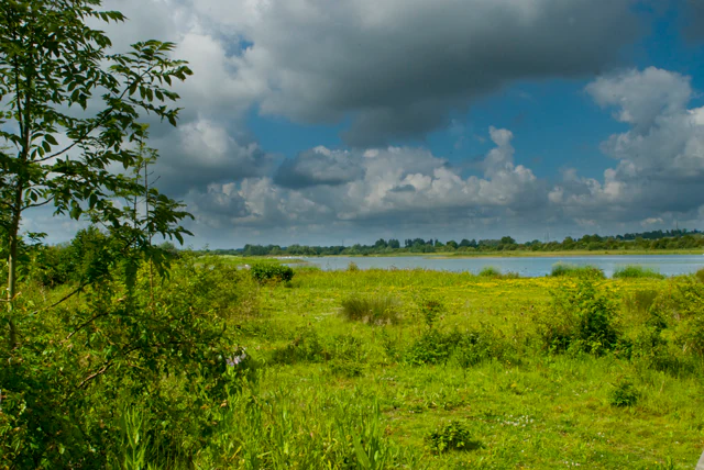
A wide landscape view of a green grassy field leading to a body of water under a sky filled with cumulus clouds.
A view across the grassy wetlands and open water at Summer Leys Nature Reserve.

Summer Leys history and protected-area timeline

Before the 1980s, the area now occupied by Summer Leys was open agricultural land, split between two fields that were farmed in conventional rotation. Mineral extraction then transformed the site: the fields were quarried for gravel by Hanson Aggregates, and the workings continued until the gravel reserves were exhausted. When extraction ended, the exhausted quarry was deliberately landscaped rather than left as an industrial scar, with new contours, waterbodies, and habitat edges shaped to encourage wildlife.

The reserve was subsequently taken on by the Wildlife Trust for Bedfordshire, Cambridgeshire, and Northamptonshire, which has managed it as a local nature reserve ever since. The wider Upper Nene Valley Gravel Pits complex of which Summer Leys is part has gone on to acquire overlapping tiers of conservation protection: Site of Special Scientific Interest status, Special Protection Area designation under the European Birds Directive, and recognition as a Ramsar wetland of international importance. The northern boundary of the reserve still follows the route of the old Northampton and Peterborough Railway, whose tracks were lifted in 1972, leaving a quiet linear feature that helps define the modern reserve. Conservation grazing, using cattle and rare-breed sheep, has become a central part of how the grassland is kept in favourable condition, supported at various points by grant funding from bodies such as the SITA Trust.

Summer Leys landscape and geographic character

The landscape of Summer Leys is essentially a designed wetland. The reserve's topography is defined by water: broad, open lagoons and reed-fringed pools sit beside gently sloping banks, short grassland, scrubby edges, and scattered woodland. Rather than a natural riverine landscape, the site is a constructed mosaic, shaped from former gravel workings into a varied system of pits, islands, and shorelines that mimic and extend the qualities of the surrounding Nene Valley floodplain.

Summer Leys ecosystems, habitats, and plant life

Ecologically, Summer Leys is dominated by wetland habitats, supported by smaller areas of species-rich grassland, broadleaved woodland, and mixed hedgerow. The waterbodies, reed margins, and open shorelines make up the core of the reserve's nature conservation value, while the terrestrial habitats provide complementary structure for invertebrates, amphibians, small mammals, and breeding birds. Conservation grazing by cattle and rare-breed sheep keeps the grasslands open and floristically varied, and the mix of habitats at relatively close range supports an unusually dense ecological community for a site of its size. The reserve fits into a larger network of similar gravel-pit wetlands across the Upper Nene Valley, all of which together sustain one of the more important wetland complexes in the English East Midlands.

Summer Leys wildlife and species highlights

Summer Leys is primarily appreciated for its birdlife. Several species of wading birds breed on the reserve, including oystercatcher, redshank, ringed plover, and little ringed plover, which use the open gravelly and muddy edges of the former workings. In winter, the site becomes a refuge for flocks of golden plover, as well as for significant numbers of pochard, shoveller, teal, tufted duck, and wigeon, with the reserve's active feeding station helping to hold these ducks close to the hides.

Mammal interest is also notable. Otters are recorded on the reserve, a presence that reflects both improving regional otter populations and the site's clean, fish-rich waterbodies. Beyond the headline birds and mammals, Summer Leys supports a meaningful invertebrate fauna: rare insects recorded at the site include the hairy dragonfly, the brown argus butterfly, and the water beetle Hydaticus transversalis, first found there in 2008. Together these records underline the reserve's role not just as a bird site but as a broadly rich wetland ecosystem.

Summer Leys conservation status and protection priorities

Summer Leys is significant at multiple tiers of conservation designation. The reserve and its neighbouring gravel pits, known collectively as the Upper Nene Valley Gravel Pits, are a Site of Special Scientific Interest, a Special Protection Area under the European Birds Directive, and a Ramsar wetland of international importance. The driving conservation interest across these designations is the site's importance for wintering wildfowl, while breeding waders, otters, and rare invertebrates add further ecological weight.

Summer Leys cultural meaning and human context

The reserve's identity is tied closely to the working landscape of the Nene Valley. The site was historically farmland before becoming a Hanson Aggregates gravel quarry, and the route of the old Northampton and Peterborough Railway, closed in 1972, still defines the northern boundary. Rather than erasing these layers, modern management has allowed the reserve to acknowledge them: a former quarry footprint has been sculpted into a recognized wetland of international importance, and a disused railway corridor now forms part of a much-loved birdwatching landscape.

Top sights and standout views in Summer Leys

Summer Leys stands out for the combination of its conservation pedigree and its accessibility. Four bird hides and a viewing screen, including one positioned over a feeding station, put visitors close to wintering ducks, flocks of golden plover, and breeding waders such as oystercatcher, redshank, and ringed plover. The reserve's layered designations, from local nature reserve through SSSI, Special Protection Area, and Ramsar status, mark it as one of the most important inland wetland sites in the East Midlands.

Best time to visit Summer Leys

Summer Leys offers a markedly different character depending on season. Winter is the most dramatic period, when significant numbers of pochard, shoveller, teal, tufted duck, wigeon, and golden plover gather on the reserve's lagoons, often within easy view of the hides and the feeding station. Late spring and early summer bring breeding activity, with oystercatcher, redshank, ringed plover, and little ringed plover present on the more open edges of the reserve. Warmer months are also rewarding for invertebrates, including hairy dragonfly and brown argus butterfly, and the supporting grassland and woodland habitats show the reserve at its most lush.

Monthly climate preview

Long term average temperature and monthly precipitation patterns recorded across twelve months

Summer Leys Climate Normals and Annual Weather Rhythm

Representative coordinate measurements track measured average monthly temperatures and precipitation rates from long term climatology records. Detailed monthly comparisons illustrate the full annual temperature range and precipitation cycle across the landscape.
Annual mean10 °C
4 °C17 °C
Jan
Feb
Mar
Apr
May12°
Jun15°
Jul17°
Aug17°
Sep14°
Oct10°
Nov
Dec
Warmest month
July

16.8 °C

Coolest month
January

3.5 °C

Wettest month
October

2.3 mm/day

Driest month
March

1.5 mm/day

Park location guide

Geography guide, regional context, and park location map for Summer Leys

Summer Leys park geography, regions, and map view in United Kingdom

Understand where Summer Leys sits in United Kingdom through a broader geographic reading of the surrounding landscape, nearby location context, and its mapped position within the national park landscape.

How Summer Leys fits into United Kingdom

The United Kingdom is a parliamentary constitutional monarchy located in northwestern Europe, consisting of four constituent countries: England, Scotland, Wales, and Northern Ireland. As a major global power with over 69 million residents, it maintains significant international influence in politics, economics, and culture.

Wider geography shaping Summer Leys in United Kingdom

The United Kingdom is an island nation located in northwestern Europe, surrounded by the Atlantic Ocean, North Sea, English Channel, Celtic Sea, and Irish Sea. It shares a land border with the Republic of Ireland to the west. The territory includes the island of Great Britain, the northeastern portion of Ireland, and most of the smaller British Isles islands.

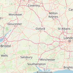
Map view of Summer Leys

Use this park location map to pinpoint Summer Leys in United Kingdom, understand its exact geographic position, and read its mapped placement within the surrounding landscape more clearly.

Pigeon | © OpenStreetMap contributors

Location context for Summer Leys

Northamptonshire

Explore the terrain, open lagoons, and protected marshland character of the reserve.

Summer Leys Photos and Landscape Scenery: Visualizing the Wetland Habitat

Visual records capture the constructed mosaic of open lagoons, reed-fringed pools, and grassy shorelines defining the protected wetland environment. Photographic documentation reveals the specialized habitats and reclaimed mineral topography shaping the regional character of the floodplain.

A wide landscape view of a green grassy field leading to a body of water under a sky filled with cumulus clouds.

A wide view of a calm lagoon at Summer Leys Nature Reserve, with dry grasses in the foreground and trees in the distance under a cloudy sky.

Park atlas

Discover related reserves and regional wildlife habitats across the Nene Valley corridor

Explore Parks Near Summer Leys and Surrounding Protected Wetland Landscapes

Continue geographic comparison by browsing other protected wetland reserves and river valley habitats situated near Summer Leys. Analyzing adjacent conservation areas provides broader context for regional bird populations and reclaimed quarry ecosystems.
Nature reserveSurrey
About 90 km away#1 closest

South

Wraysbury Reservoir: An Engineered Nature Reserve and Vital Wetland Habitat in Surrey

Examining infrastructure, ecology, and sonar testing geography.

Wraysbury Reservoir stands as a unique example of late-twentieth-century industrial landscape design, serving as both a primary London water resource and a protected Ramsar wetland. Its earthen embankments enclose a specialized environment where sonar research and ecological conservation coexist within the wider context of the Thames Valley. This record details the site's boundaries, its function as a wintering bird refuge, and its specialized role in UK marine testing.

Area
2.05 km²
Established
1970
Relief
Lowland
Climate
Temperate
National parkUnited Kingdom
About 110 km away#2 closest

Northwest

Peak District National Park: Explore Protected Landscape and Regional Geography

Mapped boundaries and natural terrain context for this UK national park.

Investigate the Peak District National Park, a cornerstone of the United Kingdom's protected natural areas. This MoriAtlas entry provides essential details on its geographic scope, mapped boundaries, and landscape characteristics. Engage with structured data to understand how this national park fits into the atlas of the United Kingdom, supporting detailed geographic and protected-area discovery for researchers and explorers.

Area
1,440 km²
Established
1951
IUCN
V
Visitors
13M annual
A soft watercolor illustration showing rolling green hills and wetlands against a light, pale sky.
Nature reserveEssex
About 115 km away#3 closest

Southeast

Abberton Reservoir: Mapped Landscape and Protected Area Context in Essex, England

Freshwater reservoir, wetland, and historic site

Abberton Reservoir stands as a landmark of regional geography in Essex. This entry maps the site's transition from an engineered water-supply facility to a mosaic of reedbeds, marshes, and open water, providing essential habitat for migratory wildfowl and wintering bird populations.

Area
7 km²
Established
1939
Relief
Lowland
Climate
Temperate
Watercolor illustration of a coastal landscape featuring green hills, white cliffs, and a body of water
National parkSouth East England
About 119 km away#4 closest

South

South Downs National Park: A Distinctive Chalk Landscape in South East England's Atlas

Iconic chalk downland, coastal cliffs, and mapped terrain.

South Downs National Park is a premier protected landscape in South East England, celebrated for its unique chalk downland terrain and dramatic coastal formations. This page provides detailed geographic context for the park, highlighting its rolling hills, dry valleys, and ancient woodlands. Discover the park's mapped boundaries and its significance within England's protected areas, offering a structured atlas view for landscape exploration.

Area
1,627 km²
Established
2010
IUCN
V
Visitors
18M annual
Nature reserveEssex
About 122 km away#5 closest

Southeast

Colne Estuary Nature Reserve: Geography and Protected Landscapes of the Essex Coast

Coastal wetlands, saltmarsh zones, and geological formations

Colne Estuary represents a massive tidal landscape in Essex characterized by the interaction between fluvial and marine systems. Covering over 2,900 hectares, this site protects diverse habitats including intertidal mudflats, active saltmarshes, and transitional zones that support wintering waterbirds. The area remains a key reference for studying coastal accretion and Quaternary geology in the East of England.

Area
29.152 km²
Established
1989
Relief
Lowland
Climate
Temperate
Marine protected areaEssex
About 130 km away#6 closest

Southeast

Blackwater, Crouch, Roach and Colne Estuaries Marine Conservation Zone Geography and Map

A comprehensive look at England's largest inshore marine protected area.

Covering 284 square kilometers of the Essex coast, this marine conservation zone integrates four tidal estuaries and North Sea coastal frontage into a single protected system. Recognized for its unique native oyster beds and vast intertidal mudflats, the area provides essential habitat for waterfowl. Explore the mapped terrain and overlapping conservation boundaries that define this vital estuarine landscape.

Area
284 km²
Relief
Lowland
Climate
Temperate
Scope
Marine
Nature reserveSuffolk
About 138 km away#7 closest

East

Martlesham Wilds Nature Reserve: Suffolk Wetland and Protected Landscape Geography

Examining the ecological corridor along the River Deben estuary

Martlesham Wilds represents a significant lowland rewilding effort in eastern England. The 117 hectare reserve, managed by the Suffolk Wildlife Trust, creates a vital connection between ancient woodlands, tidal marshes, and freshwater wetland scrapes. Explore the geographic layout and protected boundaries of this developing sanctuary on the Deben Estuary.

Area
1.17 km²
Established
2023
Relief
Lowland
Climate
Temperate
Watercolor painting showing grassy wetlands and distant hills with a sunset sky
National parkUnited Kingdom
About 141 km away#8 closest

East

The Broads National Park: Wetland Landscape, Rivers, and Regional Geography Atlas

Explore mapped waterways and protected reedbed ecosystems.

The Broads National Park offers a singular protected wetland landscape with over 200 kilometers of navigable waterways across its numerous shallow lakes, or 'broads.' Shaped by medieval peat excavations and natural processes, this area presents a unique geography of reedbeds and grazing marshes, punctuated by historic windmills. Discover the mapped extent of this protected landscape, its river systems, and its vital role in regional geography through structured atlas data.

Area
303 km²
Established
1989
IUCN
V
Relief
Lowland

Common questions about visiting, size, designation, and location context for Summer Leys

Summer Leys FAQs for park facts, access, geography, and protected area context

Find quick answers about Summer Leys, including protected-area facts, park geography, trail and visitor context, and how the park fits into its surrounding country and regional landscape.
MoriAtlas Explorer

Continue Your Protected Areas Search Across the Global Atlas

Deepen your exploration by continuing the structured search for national parks and protected areas worldwide. Utilize the comprehensive filtering capabilities to compare different conservation landscapes and refine your understanding of global park geography. Discover more about the distribution and characteristics of protected natural areas.

Global natural geography