

Mori Atlas logo
Wildlife reserveSunchubamba Game Reserve

Tracing the history, terrain, and managed vegetation of a distinct high-altitude wildlife reserve

Sunchubamba Game Reserve: A Mapped Analysis of Protected Andean Landscapes in Cajamarca Region, Peru

(Coto de Caza Sunchubamba)

Sunchubamba Game Reserve represents a unique intersection of Andean history and managed land use within the Cajamarca Region of northern Peru. Spanning approximately 600 square kilometers, this reserve features a complex landscape where native dry forest vegetation intermingles with historical tree plantations. The area offers significant insight into the evolution of protected lands, combining traditional ecological management with a storied past involving introduced species and regional resource utilization.

game reserveIUCN Category VIdry Andean foresttrophy huntingmanaged wildlifeCajamarca Region

Sunchubamba Game Reserve

Wildlife reserve

Park overview

Structured park overview, official facts, and landscape profile for Sunchubamba Game Reserve

Sunchubamba Game Reserve park facts, protected area profile, and essential visitor context

Review the core facts for Sunchubamba Game Reserve, including designation, size, terrain, visitor scale, habitats, and operating context in one park-focused overview.

About Sunchubamba Game Reserve

Sunchubamba Game Reserve occupies a significant portion of Cajamarca Province in the Cajamarca Region of northern Peru, an area historically tied to large agricultural estates and the broader agricultural transformation of the Andes. When Peru's agrarian reform dismantled the old hacienda system, lands such as those at Casa Grande were left without their former function, opening an opportunity for new conservation and land-use designations. In 1977, Sunchubamba became one of the country's officially recognized game reserves, a status that has continued to define its management under Peru's national protected areas service, SERNANP.

Ecologically, the reserve sits within dry Andean landscapes that support a mosaic of native plant communities and human-modified vegetation. Native forest patches include species such as molle (Schinus molle) and aliso (Alnus acuminata), along with grasses and other endemic plants, while portions of the reserve also include conspicuous plantations of introduced trees such as Grevillea robusta, Pinus radiata, and Cupressus species. This combination reflects the reserve's origin as former agricultural land rather than untouched wilderness, and gives it a distinctive vegetation pattern that mixes naturally regenerated forest with deliberately planted non-native trees.

Wildlife in Sunchubamba reflects the reserve's identity as a managed hunting area. Native white-tailed deer are present alongside the more unusual introduced red deer population, and smaller game species include birds such as the black-winged ground dove and the Andean tinamou. A range of protected species, including the tapeti, Andean fox, vizcacha, and raptors such as the variable hawk and American kestrel, also inhabit the area. The reserve's combination of protected status, tradition of sustainable-use management, and unusual wildlife history makes it a distinctive entry among Peru's federally recognized natural areas.

Quick facts and research context for Sunchubamba Game Reserve

Sunchubamba Game Reserve is located in Cajamarca Province, within Cajamarca Region in northern Peru, and covers approximately 59,735 hectares of Andean terrain. It is managed by SERNANP, Peru's national service of protected areas, and holds an IUCN Category VI designation, indicating that conservation is combined with the sustainable use of natural resources.

The reserve was established on April 22, 1977, on lands that had previously belonged to the Casa Grande hacienda system before Peru's agrarian reform transformed large rural estates. Trophy hunting, particularly of native white-tailed deer and introduced red deer, is the main recognized activity in the reserve, alongside scientific research and habitat management. Plant cover ranges from native dry-forest species such as molle and aliso to non-native plantations of pine, cypress, and grevillea.

Protection and recognition

Terrestrial protected area management scope and administrative records

Sunchubamba Game Reserve Protection Status and Conservation Recognition

Sunchubamba Game Reserve maintains a documented terrestrial protection scope within official conservation databases. Recorded designation parameters outline the governance framework and management boundaries governing the protected landscape.

Protection details

Protection scope
Terrestrial
Transboundary protection
No
Park context

Deeper park guide and search-rich context for Sunchubamba Game Reserve

Sunchubamba Game Reserve history, landscape, wildlife, and travel context

Explore Sunchubamba Game Reserve through its history, landscape character, ecosystems, wildlife, conservation priorities, cultural context, and seasonal travel timing in a structured park guide built for atlas discovery and search intent.

Why Sunchubamba Game Reserve stands out

Sunchubamba Game Reserve is best known as one of Peru's designated game reserves, where managed hunting has shaped both the land's character and its wildlife story. Its most distinctive feature is the long-running presence of red deer, a non-native species introduced in the mid-twentieth century that initially frightened local residents but eventually established a viable population. The reserve's mix of native Andean dry-forest vegetation with introduced plantation species adds another layer to its identity. The reserve also stands out for its historical connection to the Casa Grande hacienda system and for the early scientific experiments, including cloud seeding, that were carried out on its lands decades before formal protection. These layered stories of land reform, species introduction, and hunting heritage give Sunchubamba a profile quite different from more typical wilderness parks in Peru.

Sunchubamba Game Reserve history and protected-area timeline

Sunchubamba Game Reserve has its origins in land that was once part of the Casa Grande hacienda system, a network of large agricultural estates that shaped rural Cajamarca for much of the twentieth century. The collapse of the estate system came as low sugar prices and Peru's sweeping agrarian reform forced the closure of many haciendas, leaving significant areas without their traditional productive use.

By the late 1970s, a portion of this former hacienda landscape was designated as a game reserve, with formal establishment on April 22, 1977. Even before the reserve's official creation, the area was the site of scientific activity: cloud seeding programs were conducted during the 1950s and 1960s as part of regional drought mitigation efforts. The reserve's red deer population, today a defining part of its wildlife identity, was introduced in stages beginning in 1945, with a more successful introduction in 1948 that eventually produced a herd of several hundred animals by the early 1970s.

Sunchubamba Game Reserve landscape and geographic character

Sunchubamba Game Reserve lies within the Andean landscapes of Cajamarca Province, occupying a broad expanse of dry, mountainous terrain that was historically used for large-scale agriculture. The topography reflects the area's identity as former hacienda lands, with slopes and valleys that were once managed for sugar production and other agricultural activities before the estate system collapsed.

The vegetation pattern reinforces this human-influenced character. While areas of native dry forest remain, particularly those dominated by molle and aliso, much of the reserve features introduced plantations of fast-growing tree species such as Grevillea robusta, Pinus radiata, and Cupressus. The result is a landscape that blends regenerated native vegetation with deliberately planted non-native stands, giving Sunchubamba a distinctly modified Andean character compared with more strictly wilderness-style reserves.

Sunchubamba Game Reserve ecosystems, habitats, and plant life

The ecological character of Sunchubamba Game Reserve is defined by its position in the dry Andean zone of northern Peru and by its evolutionary path from hacienda land to protected area. Native plant communities include dry-forest species adapted to seasonal climate patterns typical of Cajamarca, alongside grasses and shrubs characteristic of the region's slopes and valleys.

A particularly notable ecological feature is the coexistence of native vegetation with substantial plantations of introduced trees, which now form part of the reserve's vegetative cover. These plantations, initially established for timber and land stabilization purposes, have become an established element of the landscape and contribute to the reserve's distinctive ecological profile.

Sunchubamba Game Reserve wildlife and species highlights

Sunchubamba Game Reserve's wildlife identity is built around its dual role as a protected area and a managed hunting ground. Native white-tailed deer represent the principal indigenous game species, while introduced red deer form perhaps the reserve's most unusual wildlife story. Brought to the area beginning in 1945 and supplemented in 1948, red deer initially met resistance from local residents unfamiliar with the species but eventually grew into a population of several hundred animals, creating one of South America's more distinctive examples of an established non-native deer herd.

Smaller game species in the reserve include birds such as the black-winged ground dove and the Andean tinamou. The reserve also supports a variety of protected wildlife, including the tapeti rabbit, the Andean fox, the vizcacha, and raptors such as the variable hawk, American kestrel, and aplomado falcon. Together, these species give Sunchubamba a wildlife profile shaped by both hunting heritage and broader ecological importance.

Sunchubamba Game Reserve conservation status and protection priorities

Sunchubamba Game Reserve holds an IUCN Category VI designation, placing it within the framework of protected areas that emphasize the sustainable use of natural resources alongside conservation goals. Managed by Peru's national parks authority SERNANP, the reserve represents a particular conservation approach in which regulated hunting is part of the protection strategy rather than excluded from it.

The reserve's conservation significance lies not only in the persistence of native dry-forest vegetation and native wildlife such as the white-tailed deer, but also in the unusual ecological situation presented by the long-established red deer population. Its history as former hacienda land and its continuing vegetation mosaics of native and introduced trees make it a distinctive case study in how Andean landscapes can be conserved and managed simultaneously.

Sunchubamba Game Reserve cultural meaning and human context

Sunchubamba's cultural context is closely tied to the hacienda era of northern Peru and to the broader social transformations that followed. The reserve was carved from lands that had been part of the Casa Grande estate system, an enduring symbol of the large-landlord agricultural order that was dismantled by Peru's agrarian reform. The shift from sugar hacienda to protected game reserve reflects the major rural restructuring of the twentieth century.

Local memory also shapes the reserve's identity, particularly with respect to wildlife. Early encounters with introduced red deer in the 1940s were marked by fear and misunderstanding among residents, who reportedly killed individual animals out of unfamiliarity with the species. Today, the reserve's mixed legacy of estate agriculture, species introduction, hunting tradition, and scientific experimentation forms a distinctive part of its cultural and regional significance within Cajamarca.

Top sights and standout views in Sunchubamba Game Reserve

Sunchubamba stands out for the unusual combination of dry Andean habitat, historic hacienda lands, a deliberately managed hunting program, and the long-established presence of introduced red deer. The coexistence of native dry-forest species with substantial non-native tree plantations gives it a distinctive vegetation profile worth noting, while the reserve's role as a site of early cloud seeding research adds another layer of historical interest.

Best time to visit Sunchubamba Game Reserve

Sunchubamba Game Reserve sits within the dry Andean landscapes of Cajamarca, where seasonal conditions shape the appearance of the landscape and the character of a visit. The region's climate is characterized by a clear distinction between a wetter growing season and a drier period, and these patterns influence vegetation condition, wildlife visibility, and the general atmosphere of the highland terrain.

Visiting during the drier months can favor clearer views of the slopes and easier access to game-related sites, while the wetter season typically brings greener vegetation and a different character to native forest patches. Because the reserve's main activity is managed hunting, visitors interested in observing wildlife or landscape rather than participating in hunting should consider the seasonal patterns that best suit observational and scenic purposes.

Monthly climate preview

Long term monthly temperature and precipitation patterns across representative coordinates

Sunchubamba Game Reserve Climate Normals and Annual Temperature Rhythm

Sunchubamba Game Reserve exhibits a measured annual temperature and precipitation rhythm derived from NASA Power climatology records spanning from 1991 to 2020. Examining the complete monthly climate profile reveals detailed variations in average temperature and precipitation across the protected area.
Annual mean19 °C
18 °C20 °C
Jan18°
Feb18°
Mar18°
Apr19°
May19°
Jun19°
Jul19°
Aug19°
Sep20°
Oct19°
Nov18°
Dec18°
Warmest month
September

19.9 °C

Coolest month
November

18.1 °C

Wettest month
March

2.1 mm/day

Driest month
August

0.1 mm/day

Park location guide

Geography guide, regional context, and park location map for Sunchubamba Game Reserve

Sunchubamba Game Reserve park geography, regions, and map view in Peru

Understand where Sunchubamba Game Reserve sits in Peru through a broader geographic reading of the surrounding landscape, nearby location context, and its mapped position within the national park landscape.

How Sunchubamba Game Reserve fits into Peru

Peru is a megadiverse country in western South America with a population of over 34 million. It spans three distinct geographic regions: the Pacific coastal desert in the west, the Andes mountains running north to south, and the Amazon rainforest in the east. The country has one of the longest histories of civilization in the world, tracing back to the Caral-Supe civilization of the 10th millennium BCE, and was home to the Inca Empire before Spanish colonization in the 16th century.

Wider geography shaping Sunchubamba Game Reserve in Peru

Peru is located in western South America along the Pacific coast. The country encompasses three major geographic regions: the coastal desert plains along the Pacific, the Andes mountain range extending from north to southeast, and the Amazon basin rainforest in the eastern interior. It shares borders with Ecuador and Colombia to the north, Brazil to the east, Bolivia to the southeast, and Chile to the south.

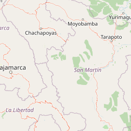
Map view of Sunchubamba Game Reserve

Use this park location map to pinpoint Sunchubamba Game Reserve in Peru, understand its exact geographic position, and read its mapped placement within the surrounding landscape more clearly.

Pigeon | © OpenStreetMap contributors

Location context for Sunchubamba Game Reserve

Cajamarca Region
Recorded earthquake history

Review Recorded Earthquake History near Sunchubamba Game Reserve

Access a structured catalogue of historical seismic events associated with the geography of Sunchubamba Game Reserve. MoriAtlas provides this data for geographic exploration of the Cajamarca region, allowing users to view event details and distance metrics in a clear, factual format.

Sunchubamba Game Reserve Earthquake History

Catalogued events

8 events

Strongest magnitude

Magnitude 6

Most recent event

Jan 22, 2018

This history includes earthquakes recorded inside the park or within 50 km of its borders

Park atlas

Compare regional park geography and adjacent northern Peru conservation landscapes

Parks Near Sunchubamba Game Reserve and Surrounding Andean Protected Areas

Browsing other protected areas near Sunchubamba Game Reserve reveals the broader ecological patterns shaping the dry Andean slopes of northern Peru. Expanding the comparison across surrounding regional reserves offers deeper context into highland terrain and managed natural habitats.
Wildlife reserveCajamarca
71 km away#1 closest

Northwest

Bosques Nublados de Udima Wildlife Refuge: Protected Andean Cloud Forest and River Basin

A critical mountain reserve in the Cajamarca region of northern Peru.

Situated on the dramatic western slopes of the Andes, Bosques Nublados de Udima Wildlife Refuge protects 12,183 hectares of cloud forest ecosystem. The reserve is characterized by a sharp vertical gradient dropping over 1,000 metres toward the Zaña River basin, preserving both rare Amazonian-linked plant species and significant pre-Columbian archaeological irrigation structures.

Area
121.83 km²
Established
2011
IUCN
IV
Relief
Mountain
National parkSan Martín Region
85 km away#2 closest

East

Rio Abiseo National Park: Peru's Protected Landscape Identity and Geographic Context

Discover the mapped boundaries and regional atlas information.

Investigate Rio Abiseo National Park, a designated national park situated within the San Martín Region of Peru. This detailed entry focuses on its protected landscape characteristics and its specific geographic placement. Understand the park's mapped boundaries and its role in the broader atlas of protected areas, offering a structured approach to geographic discovery.

Area
2,745.2 km²
Established
1983
IUCN
II
Relief
Mountain
Protected areaCajamarca Region
112 km away#3 closest

Northwest

Pagaibamba Protection Forest: Geography and Protected Area Landscape Analysis

Highland Watershed Protection in the Cajamarca Andes

Pagaibamba Protection Forest represents a key protected land entity in northern Peru. Focused on maintaining the local water cycle, the area showcases dense cloud forest vegetation and steep Andean terrain. Use this mapping data to analyze its ecological boundaries, watershed significance, and regional landscape context in the Cajamarca department.

Area
20.784 km²
Established
1987
IUCN
VI
Relief
Mountain
National parkCajamarca Region
112 km away#4 closest

North

Cutervo National Park: Peru's Oldest National Park Atlas and Protected Landscape

Andean Montane Forests and Mapped Geography of a Pioneering Protected Area

As Peru's oldest national park, established in 1961, Cutervo National Park offers a unique glimpse into the protected geography of the northern Peruvian Andes. Located in the Cajamarca Region, it preserves diverse Andean montane forests and páramo grasslands across a significant elevation gradient from 1,550 to 3,500 meters. This page details the park's landscape, including its role as a headwater conservation area and its position within a critical South American ecoregion, providing rich context for geographic and protected-area exploration.

Area
82.14 km²
Established
1961
IUCN
II
Relief
Mountain
Wildlife reserveLambayeque Region
147 km away#5 closest

Northwest

Laquipampa Wildlife Refuge: Geography and Protected Area Map of Northern Peru

Tracing the tropical dry forest boundaries of the Lambayeque Region

Laquipampa Wildlife Refuge stands as a critical protected landscape within the Lambayeque Region, preserving rare tropical dry forest ecosystems along the western Andean foothills. The refuge features a unique vertical gradient, ranging from exposed dry-forest slopes to moist highland ravines. Use this atlas resource to understand the park's mapped boundaries, diverse terrain, and central role in regional conservation.

Area
113.47 km²
Established
2006
IUCN
IV
Visitors
2K annual
National parkAncash
153 km away#6 closest

Southeast

Huascarán National Park: Protected Landscape and Regional Geography in Ancash, Peru

Explore the mapped boundaries of this significant national park.

Huascarán National Park is a protected national park located in the Ancash region of Peru, offering valuable insights for geographic and atlas exploration. This destination provides detailed information on the park's mapped boundaries, its designation as a national park, and its integration into the regional geography. Understanding Huascarán National Park helps contextualize protected land distribution and landscape features within Peru for those interested in structured geographic discovery and atlas-style mapping.

Area
3,400 km²
Established
1975
IUCN
II
Relief
Mountain
A watercolor illustration of layered green hills and distant mountain ridgelines, depicted in soft pastel tones against a white background.
Nature reserveSan Martin
162 km away#7 closest

Northeast

Alto Mayo Protection Forest: Geographic Boundaries and Andean Slope Landscape Mapping

Protected watershed and cloud forest in San Martin, Peru

Spanning the eastern Andes, Alto Mayo Protection Forest functions as a foundational watershed for the Mayo River basin. This reserve preserves significant cloud forest habitats and high-gradient terrain, serving as an important link between Andean highlands and the Amazonian lowlands. Study the topographic features, hydrological network, and protected boundaries that define this crucial Peruvian wilderness.

Area
1,820 km²
Established
1987
IUCN
VI
Relief
Mountain
National parkPeru
185 km away#8 closest

East

Cordillera Azul National Park: A National Park for Geographic Discovery in Peru

Explore Peru's protected landscape and regional map context.

Cordillera Azul National Park serves as a dedicated entry point for understanding Peru's protected natural areas through a geographic lens. This park's identity is tied to its specific mapped boundaries and its contribution to the nation's diverse terrain. Focusing on Cordillera Azul National Park allows for detailed atlas exploration of its unique landscape context within western South America, providing factual data for geographic understanding.

Area
13,531.9 km²
Established
2001
IUCN
II
Relief
Mountain

Common questions about visiting, size, designation, and location context for Sunchubamba Game Reserve

Sunchubamba Game Reserve FAQs for park facts, access, geography, and protected area context

Find quick answers about Sunchubamba Game Reserve, including protected-area facts, park geography, trail and visitor context, and how the park fits into its surrounding country and regional landscape.
MoriAtlas Explorer

Continue Your Protected Areas Search Across the Global Atlas

Deepen your exploration by continuing the structured search for national parks and protected areas worldwide. Utilize the comprehensive filtering capabilities to compare different conservation landscapes and refine your understanding of global park geography. Discover more about the distribution and characteristics of protected natural areas.

Global natural geography