Why Taal Volcano Protected Landscape stands out
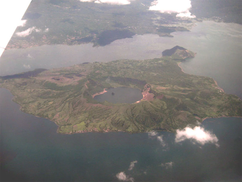
Taal Volcano Protected Landscape is best known for the unusual nested volcanic geography of Taal Volcano, where a broad main caldera filled by Taal Lake contains a volcanic island that in turn holds its own crater lake. This distinctive island-within-a-lake-within-an-island structure, combined with the scale of the surrounding lake-filled caldera, makes the area one of the most visually recognizable volcanic settings in the Philippines. Beyond its volcanic signature, the protected landscape also draws attention for its endemic freshwater fauna, particularly Sardinella tawilis, a commercially important sardine whose range is restricted entirely to the waters of Taal Lake. Together the volcanic landforms and the endemic lake biota define the area's most distinctive identity.
Taal Volcano Protected Landscape history and protected-area timeline
The Taal Volcano Protected Landscape was formally established in 1996 as a nationally designated protected natural area under the Philippine system, with the aim of safeguarding the volcanic system around Taal Volcano and the encompassing Taal Lake. The designation recognized both the geological significance of the caldera complex and the ecological value of the surrounding landscape across southern Luzon.
In 2006, the Department of Environment and Natural Resources proposed the area for inclusion on the UNESCO World Heritage List, an indication that its natural values were considered at a level beyond purely national recognition. The proposal reflected the area's combination of distinctive volcanic landforms, a large lake, and endemic freshwater biodiversity centered on Taal Lake.
Over time the protected area has also been the subject of biological surveys and research. A 2005 biodiversity monitoring exercise documented avian presence within the reserve, recording around 32 bird species including several Philippine endemics, and later studies such as those cataloguing the fungi of the Taal Volcano Protected Landscape have contributed to a growing understanding of the area's wider ecological character.
Taal Volcano Protected Landscape landscape and geographic character
The defining landscape feature of the Taal Volcano Protected Landscape is the Taal caldera system, a broad volcanic depression whose main crater has been filled almost entirely by Taal Lake. Rather than a single towering cone, the volcano presents a layered topography where land and water alternate at different scales, with a volcanic island rising from the center of the main lake and that smaller island itself containing its own crater lake.
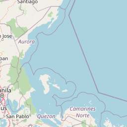
Beyond the central caldera, the protected landscape extends across a wide perimeter that includes the rim of the caldera, surrounding ridges, and lower-lying lands that slope toward the lake. These outer fringes accommodate agricultural areas, settlements, and the elevated plateau on which Tagaytay sits, giving the protected area a gradient from dramatic volcanic scenery to more gently rolling inhabited terrain.
The visual signature of the area is the contrast between the broad expanse of Taal Lake, the dark volcanic island at its center, and the encircling ridges of the caldera rim, which form a near-continuous skyline when viewed from popular viewpoints on the surrounding plateau. This combination of a large crater lake, an inner island, and encircling highlands gives the protected landscape one of the most recognizable volcanic panoramas in the Philippines.
Taal Volcano Protected Landscape ecosystems, habitats, and plant life
The Taal Volcano Protected Landscape encompasses a layered mix of terrestrial, freshwater, and volcanic habitats, with forest patches on the caldera rim and slopes, open areas around the lake, and the lacustrine ecosystem of Taal Lake itself. The combination of a major volcanic island, surrounding waters, and the higher ground of the caldera rim produces a varied ecological setting within a relatively compact geographic area.
The freshwater environment of Taal Lake is central to the area's ecological identity. The lake supports around fifty fish species, a diversity that allows a commercial fishery to operate within its waters. Among these, the endemic freshwater sardine Sardinella tawilis stands out as a species of particular ecological and economic importance, with its range restricted entirely to Taal Lake.
On land, the vegetation of the protected area reflects the influence of volcanic soils and elevation, supporting a mix of forest cover, scrub, and agricultural landscapes around the inhabited edges of the reserve. The protected landscape thus combines a relatively undisturbed caldera-lake ecological core with a broader surrounding matrix that includes both natural habitats and human-modified land.
Taal Volcano Protected Landscape wildlife and species highlights
The wildlife profile of the Taal Volcano Protected Landscape is shaped by its position on Luzon and by the unusual presence of a large lake at the heart of the protected area. A biodiversity monitoring effort carried out in 2005 recorded approximately 32 bird species within the reserve, a relatively modest species count that nonetheless includes a significant share of Philippine endemic birds.
Among the endemic birds documented during that survey are the white-eared brown dove (Phapitreron leucotis), the elegant tit (Pardaliparus elegans), the Philippine tailorbird (Orthotomus castaneiceps), the Luzon tailorbird (Orthotomus derbianus), the Philippine bulbul (Hypsipetes philippinus), the Philippine pygmy woodpecker (Yungipicus maculatus), and the stripe-headed creeper (Rhabdornis mystacalis). The presence of multiple Luzon and Philippine endemics gives the area a particular relevance for the conservation of the island's avifauna.
The most distinctive wildlife feature of the protected landscape is the endemic freshwater sardine Sardinella tawilis, which lives only in the waters of Taal Lake and is recognized as the only commercially important freshwater sardine in the world. Its restricted range makes the lake's ecological condition a matter of direct conservation concern, and the species has become a signature element of the area's biodiversity.
Taal Volcano Protected Landscape conservation status and protection priorities
Conservation in the Taal Volcano Protected Landscape centers on the protection of a nationally significant volcanic and lacustrine system that combines active volcanism, a large crater lake, and surrounding terrestrial habitats on southern Luzon. The protected-area designation, established in 1996, frames the area as an integrated landscape where the volcano, the lake, and the encircling land are managed as a single ecological unit rather than as separate features.
The ecological importance of the area extends well beyond its geological drama. Taal Lake harbors an endemic freshwater fauna, most notably Sardinella tawilis, whose entire range is confined to the lake, making the lake's condition a direct determinant of the species' long-term survival. The presence of multiple endemic birds reinforces the area's value for the conservation of Philippine island biodiversity.
The proposal made in 2006 by the Department of Environment and Natural Resources to place the area on the UNESCO World Heritage List reflects the recognition of its natural values at an international scale. Even without formal inscription, this proposal underscores how the Taal system is regarded as a landscape of global interest, where volcanic processes, freshwater ecology, and island biogeography converge within a single protected perimeter.
Taal Volcano Protected Landscape cultural meaning and human context
The Taal Volcano Protected Landscape sits within a region of long-standing human settlement, where communities living around the volcano and the lake have shaped and been shaped by the volcanic landscape for generations. The municipalities within the protected perimeter, such as Talisay, Tanauan, and Laurel along the lake, and Tagaytay on the elevated rim, have economies and identities closely tied to the lake, the surrounding agricultural lands, and the dramatic scenery of the caldera.
Taal Volcano itself has a deep place in Philippine cultural imagination as one of the country's most recognizable natural landmarks, long featured in visual depictions of the country and visited from the elevated viewpoints around Tagaytay. The city of Tagaytay, partially within the protected area, has grown around the panoramic views of the lake and volcanic island below, illustrating how the volcanic landscape continues to define the cultural and visitor identity of the surrounding region.
The presence of inhabited towns and agricultural land within the protected perimeter means that conservation efforts operate in a context where local livelihoods, traditional land use, and the protection of a still-active volcanic system must be considered together.
Top sights and standout views in Taal Volcano Protected Landscape
Taal Volcano Protected Landscape is distinguished by the nested volcanic geography at its core, where the broad Taal caldera holds Taal Lake and a central volcanic island that itself contains a smaller crater lake, creating a layered island-in-lake-in-island landform within a single protected system.
The area is also notable for its endemic freshwater fauna, anchored by Sardinella tawilis, the only commercially important freshwater sardine in the world and a species found exclusively in Taal Lake. Combined with the documented presence of several Philippine endemic bird species, this gives the protected landscape both a strong geological and a strong ecological identity that sets it apart from other protected areas in the country.
Best time to visit Taal Volcano Protected Landscape
The Taal Volcano Protected Landscape lies in a part of the Philippines with a tropical climate, where conditions are shaped more by rainy and drier periods than by traditional four-season distinctions. The cooler and generally drier months, broadly corresponding to the northern dry season from late November through early May, tend to offer clearer views across Taal Lake from elevated points such as Tagaytay and more settled conditions for outdoor appreciation of the caldera landscape.
During the wetter months, views across the lake and the volcanic island can be obscured by rain, cloud, and mist rising from the crater lake and surrounding ridges, while vegetation across the landscape becomes noticeably greener. The visual contrast between the dry-season clarity over the lake and the lush, cloud-veiled appearance of the rainy season gives the protected landscape a distinctly different character at different times of year, and visitors interested in the panoramic caldera scenery will generally find the drier months the most rewarding for landscape views.