

Mori Atlas logo
Marine protected areaTaipari Roa (Elizabeth Island) Marine Reserve

Understanding the glacial fjord terrain and stratified marine habitats in Doubtful Sound

Taipari Roa (Elizabeth Island) Marine Reserve: Mapped Geography and Protected Marine Landscapes

Taipari Roa (Elizabeth Island) Marine Reserve represents a critical protected marine ecosystem within the dramatic fjord topography of Fiordland. This landscape detail captures the vertical rock walls, extensive kelp forests, and unique saltwater-freshwater stratification that define the underwater terrain surrounding Elizabeth Island. By mapping these specialized benthic habitats and protected boundaries, the atlas provides a clear context for the rare coral communities, glass sponges, and avian habitats found across this sheltered portion of Doubtful Sound.

marine reservefiord ecosystemdoubtful soundfiordlandsouth islandnew zealand
A stylized flat-design illustration of a tall, green, pointed mountain rising above a blue body of water, surrounded by lush coastal foliage and other smaller, distant peaks under a soft-colored sky.

Taipari Roa (Elizabeth Island) Marine Reserve

Marine protected area

Park overview

Structured park overview, official facts, and landscape profile for Taipari Roa (Elizabeth Island) Marine Reserve

Taipari Roa (Elizabeth Island) Marine Reserve park facts, protected area profile, and essential visitor context

Review the core facts for Taipari Roa (Elizabeth Island) Marine Reserve, including designation, size, terrain, visitor scale, habitats, and operating context in one park-focused overview.

About Taipari Roa (Elizabeth Island) Marine Reserve

Taipari Roa (Elizabeth Island) Marine Reserve is one of New Zealand's smaller but ecologically distinctive marine reserves, located deep within the Fiordland wilderness on the southwestern coast of the South Island. It sits in the inner part of Doubtful Sound / Patea, one of the most remote and dramatically carved fiord systems in the Southern Hemisphere, and surrounds Elizabeth Island along with smaller neighbouring islets such as Rolla Island.

The reserve's character is defined largely by the unusual oceanography of Fiordland's fiords. Extremely high rainfall runs off the surrounding steep mountains and creates a permanent layer of freshwater that floats on top of the denser seawater below. In places, this freshwater cap ranges from just a few centimetres thick to as deep as ten metres, and beneath it lies a calm, clear, and relatively warm saltwater layer. This unusual stratification means that species normally found much deeper offshore can thrive here at depths accessible to divers, making the marine environment around Elizabeth Island a natural laboratory for studying cold-temperate fiord ecosystems.

The underwater terrain itself is varied. An extensive rock wall habitat runs along the western side of Elizabeth Island, while the southern side of the island gives way to deep kelp beds. On the eastern side, a shallower channel supports a community of suspension feeders, including black corals, red corals, and zoanthids, anchored in currents that bring food past the steep rock faces. Scattered through the reserve are bright yellow glass sponges that are not found elsewhere, highlighting the site's importance for endemic and localised marine biodiversity.

Above the waterline, the reserve protects breeding and roosting habitat for the Fiordland Crested Penguin on Rolla Island and supports regular visits by bottlenose dolphins. Together, these terrestrial, intertidal, and submarine features make the reserve a compact but unusually complete representation of Doubtful Sound's marine life.

The reserve was formally established in 2005 following a multi-year campaign led by the Fiordland Marine Guardians, who presented their conservation strategy to the New Zealand government in 2003. Today it is managed by the Department of Conservation with input from the Ministry of Primary Industries, the Fiordland Marine Guardians, and Ngāi Tahu. Strict fishing and extraction rules apply, anchoring is restricted in vulnerable areas, and research, diving, snorkelling, and scenic boat visits are the primary recognised human activities.

Quick facts and research context for Taipari Roa (Elizabeth Island) Marine Reserve

Taipari Roa (Elizabeth Island) Marine Reserve lies in the inner Fiordland, within Doubtful Sound / Patea on the southwestern coast of New Zealand's South Island. Covering 613 hectares, it was officially established on 21 April 2005 and is administered by the Department of Conservation. The site was created partly in response to environmental changes in Doubtful Sound associated with the Manapouri Power Station, which altered the fiord's freshwater dynamics after being built in 1969.

Protection and recognition

Documented marine protection scope and official designation records

Taipari Roa (Elizabeth Island) Marine Reserve Protection Status

Marine protection status and management scope details are compiled for Taipari Roa (Elizabeth Island) Marine Reserve. Official conservation records outline the protected area framework without external international recognition sources.

Protection details

Protection scope
Marine
Transboundary protection
No
Park context

Deeper park guide and search-rich context for Taipari Roa (Elizabeth Island) Marine Reserve

Taipari Roa (Elizabeth Island) Marine Reserve history, landscape, wildlife, and travel context

Explore Taipari Roa (Elizabeth Island) Marine Reserve through its history, landscape character, ecosystems, wildlife, conservation priorities, cultural context, and seasonal travel timing in a structured park guide built for atlas discovery and search intent.

Why Taipari Roa (Elizabeth Island) Marine Reserve stands out

The reserve is most notable for its unusual vertical layering of marine habitats: a thin freshwater cap sits above clear, calm, relatively warm seawater that supports a striking community of deep-water species at unusually shallow depths. The western side of Elizabeth Island drops into extensive rock walls, the southern side hosts deep kelp beds, and the eastern channel shelters black corals, red corals, zoanthids, and bright yellow glass sponges. These glass sponges are considered unique to this part of Fiordland and are closely associated with underwater cave systems in the area, giving Taipari Roa a strong scientific and conservation profile.
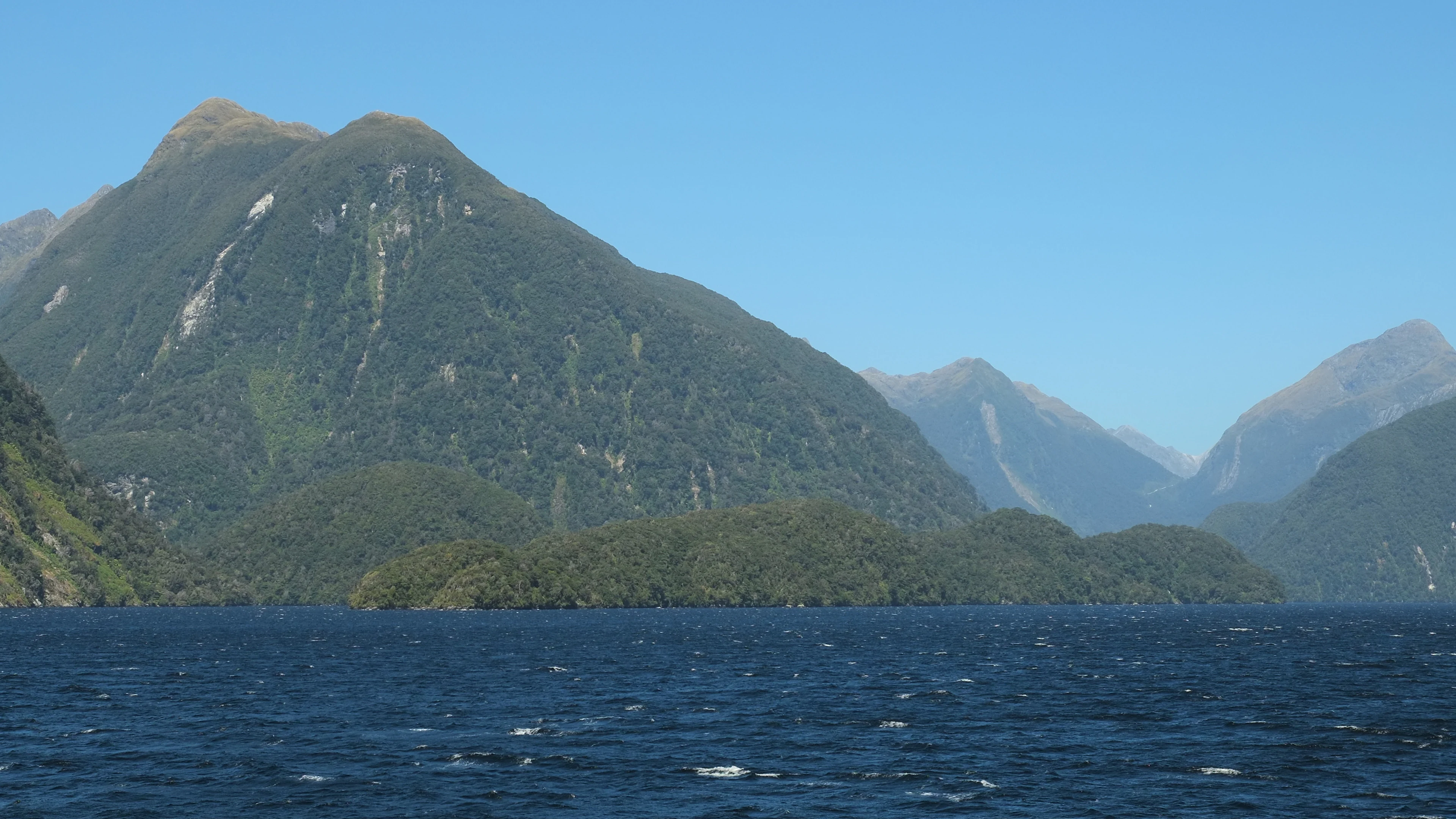
A wide view of a forest covered island surrounded by dark blue water, with steep mountains rising in the background under a clear sky.
Elizabeth Island situated within the waters of Doubtful Sound in Fiordland, New Zealand.

Taipari Roa (Elizabeth Island) Marine Reserve history and protected-area timeline

The history of Taipari Roa Marine Reserve is closely tied to the broader story of Doubtful Sound and the environmental consequences of large-scale hydroelectric development in Fiordland.

Fiordland itself was shaped by glacial activity during past ice ages, which carved deep valleys and left steep-sided islands such as Elizabeth Island rising dramatically from the water. The construction of the Manapouri Power Station in 1969 significantly altered the natural hydrography of Doubtful Sound by diverting additional freshwater from Lake Manapouri through a long tunnel into the Sound. This change in freshwater input created a thicker and more persistent low-salinity surface layer than would occur naturally, affecting the marine life around Elizabeth Island, including its black coral communities.

In response to growing environmental concern, the Fiordland Marine Guardians launched a conservation strategy in 2002 and formally presented it to the Minister for the Environment Marian Hobbs and the Minister of Fisheries Pete Hodgson in 2003. The marine reserve protecting the waters around Elizabeth Island was a key outcome of this process, and it was officially established on 21 April 2005. Since then, ongoing collaboration between the Department of Conservation, the Ministry of Primary Industries, the Fiordland Marine Guardians, and Ngāi Tahu has focused on protecting the reserve's fragile species, preventing the spread of invasive seaweed, and supporting research and education.

Taipari Roa (Elizabeth Island) Marine Reserve landscape and geographic character

The landscape of Taipari Roa (Elizabeth Island) Marine Reserve is defined by the dramatic topography of inner Fiordland. Steep, glacially carved mountains rise sharply from the sea, and the reserve is centred on Elizabeth Island and the smaller Rolla Island, which sit within the narrow, sheltered channels of inner Doubtful Sound / Patea.

Below the surface, the marine landscape mirrors the severity of the land above. Vertical rock walls and cliffs extend underwater along the western side of Elizabeth Island, creating a habitat that resembles a submerged extension of the surrounding fiord walls. On the southern side, the seafloor transitions into deeper soft-bottomed terrain that supports extensive kelp beds, while the eastern channel is a relatively shallow passage where complex hydrology supports diverse invertebrate communities.

Taipari Roa (Elizabeth Island) Marine Reserve ecosystems, habitats, and plant life

The reserve's nature is shaped by the unusual freshwater stratification of Fiordland's fiords and the wide range of habitats packed into a small area. The freshwater layer above creates a turbid, low-salinity cap while the deeper saltwater is clearer and warmer, producing conditions that allow deep-water species to exist within reach of sunlight.

This stratification underpins an unusually diverse range of habitats: vertical rock walls that support encrusting communities, deeper channels rich in kelp, and current-swept shoals where suspension-feeding invertebrates thrive. The combination of cool temperate waters, sheltered conditions, and varied substrate makes the reserve an important refuge for species that are sensitive to disturbance and difficult to find elsewhere.

Taipari Roa (Elizabeth Island) Marine Reserve wildlife and species highlights

The wildlife of Taipari Roa extends from the intertidal zone down to the deeper kelp and coral communities. The reserve is recognised as important habitat for the Fiordland Crested Penguin, which uses Rolla Island, on the southern side of the reserve, for breeding and roosting.

Marine fauna includes regular visits by bottlenose dolphins, which move through the channels of Doubtful Sound and are considered an important part of the reserve's wildlife appeal. Beneath the surface, the layered water column supports a rich community of sponges, corals, and fish diversity strongly associated with the deeper saltwater layer. The channel habitats shelter black corals, red corals, zoanthids, and striking bright yellow glass sponges that are unique to this part of Fiordland, alongside broad fish and invertebrate diversity in the kelp beds and rock wall communities.

Taipari Roa (Elizabeth Island) Marine Reserve conservation status and protection priorities

From a conservation perspective, Taipari Roa is significant both as a refuge for endemic fiord species and as a response to a major environmental change in Doubtful Sound. The freshwater cap created by Manapouri Power Station altered conditions for sensitive species such as the black corals around Elizabeth Island.

By formally protecting the waters around Elizabeth Island, the reserve safeguards ecosystems that have already been affected by altered freshwater dynamics and limits additional human pressure. Management focuses on preventing anchor damage to fragile benthic communities, restricting extraction, controlling invasive seaweed, and supporting scientific research that improves understanding of fiord ecosystems.

Taipari Roa (Elizabeth Island) Marine Reserve cultural meaning and human context

The reserve sits within the rohe of Ngāi Tahu, who hold customary rights recognised in its management arrangements. While fishing and marine extraction are otherwise prohibited, Ngāi Tahu are permitted to gather pounamu (greenstone) by hand, and to collect deceased marine mammals along with teeth and bones, in keeping with tikanga and traditional kaitiaki responsibilities. This reflects a broader recognition of Māori cultural heritage in the stewardship of Fiordland's marine environments.

Top sights and standout views in Taipari Roa (Elizabeth Island) Marine Reserve

A small but ecologically dense marine reserve inside Doubtful Sound / Patea, Taipari Roa stands out for its unusual freshwater-over-saltwater stratification, deep kelp forests, rock wall habitat, and a concentration of coral and sponge species typically found at greater depths. Its glass sponges are unique to this fiord, and the reserve supports both Fiordland Crested Penguin breeding habitat and regular bottlenose dolphin visits.

Best time to visit Taipari Roa (Elizabeth Island) Marine Reserve

Conditions in Doubtful Sound are influenced by Fiordland's high rainfall, mild temperatures, and long daylight hours in summer. Calm, settled weather during the warmer months generally offers the clearest underwater visibility and the most comfortable conditions for diving, snorkelling, and scenic cruises, while winter brings cooler temperatures and more variable weather that can reduce visibility but also produces dramatic fiord scenery.

Monthly climate preview

Long-term temperature ranges and monthly precipitation patterns sampled across representative park coordinates

Taipari Roa (Elizabeth Island) Marine Reserve Climate Normals and Annual Weather Rhythm

Taipari Roa (Elizabeth Island) Marine Reserve exhibits a measured annual temperature and precipitation rhythm derived from NASA Power climatology records. Reviewing the complete twelve-month profile provides deeper insight into long-term meteorological variations across the protected marine geography.
Annual mean9 °C
5 °C12 °C
Jan12°
Feb12°
Mar11°
Apr
May
Jun
Jul
Aug
Sep
Oct
Nov
Dec11°
Warmest month
February

12.2 °C

Coolest month
July

5.1 °C

Wettest month
October

8.6 mm/day

Driest month
July

6.6 mm/day

Park location guide

Geography guide, regional context, and park location map for Taipari Roa (Elizabeth Island) Marine Reserve

Taipari Roa (Elizabeth Island) Marine Reserve park geography, regions, and map view in New Zealand

Understand where Taipari Roa (Elizabeth Island) Marine Reserve sits in New Zealand through a broader geographic reading of the surrounding landscape, nearby location context, and its mapped position within the national park landscape.

How Taipari Roa (Elizabeth Island) Marine Reserve fits into New Zealand

New Zealand is an island nation in the southwestern Pacific Ocean comprising two main islands and numerous smaller islands. Located east of Australia across the Tasman Sea, it features varied topography with the Southern Alps running along the South Island and volcanic terrain on the North Island. The country was settled by Maori people between 1280 and 1350, followed by European exploration beginning in 1642, and became a Dominion in 1907 before gaining full independence in 1947.

Wider geography shaping Taipari Roa (Elizabeth Island) Marine Reserve in New Zealand

New Zealand lies in the southwestern Pacific Ocean, east of Australia across the Tasman Sea. The country consists of two main islands, the North Island and South Island, plus over 600 smaller islands. The North Island features volcanic plateaus and hills while the South Island is dominated by the Southern Alps mountain range. The country has a long coastline and is surrounded by the Pacific Ocean.

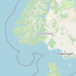
Map view of Taipari Roa (Elizabeth Island) Marine Reserve

Use this park location map to pinpoint Taipari Roa (Elizabeth Island) Marine Reserve in New Zealand, understand its exact geographic position, and read its mapped placement within the surrounding landscape more clearly.

Pigeon | © OpenStreetMap contributors

Location context for Taipari Roa (Elizabeth Island) Marine Reserve

Fiordland
Recorded earthquake history

View Historical Earthquake Records for Taipari Roa (Elizabeth Island) Marine Reserve

Access a structured catalogue of historical seismic events linked to the geographic area of Taipari Roa (Elizabeth Island) Marine Reserve. MoriAtlas provides a clear, data-driven approach to reviewing recorded earthquake activity near this Fiordland marine protected site for consistent research and exploration.

Taipari Roa Earthquake History

Catalogued events

477 events

Strongest magnitude

Magnitude 7.2

Most recent event

Aug 1, 2026

This history includes earthquakes recorded inside the park or within 50 km of its borders

Visual reference collection highlighting protected marine habitats, deep kelp forests, and glacial fiord topography.

Taipari Roa (Elizabeth Island) Marine Reserve Photos, Scenery, and Landscapes

Visual documentation captures the dramatic underwater terrain and steep glacial topography defining Taipari Roa (Elizabeth Island) Marine Reserve. Detailed imagery reveals vertical rock walls, submerged coral communities, and unique glass sponge habitats across the protected fiord environment.

A wide view of a forest covered island surrounded by dark blue water, with steep mountains rising in the background under a clear sky.

Park atlas

Compare adjacent fiord habitats and regional marine reserves across the southern landscape

Explore Protected Areas and Other Parks Near Taipari Roa (Elizabeth Island) Marine Reserve

Browsing other protected areas near Taipari Roa (Elizabeth Island) Marine Reserve reveals a wider network of glacial marine habitats and coastal reserves. Analyzing connected ecosystems across the surrounding region helps contextualize local biodiversity patterns and underwater terrain.
National parkSouthland Region
Park boundaries overlap#1 closest

East

Fiordland National Park: A Protected Landscape of Glacier-Carved Fiords and Alpine Wilderness

Explore its vast boundaries and unique temperate rainforest.

Fiordland National Park, located in the Southland Region of New Zealand, is a testament to dramatic geological forces, featuring fifteen major fiords like Milford Sound, whose Mitre Peak rises majestically from the water. This protected national park encompasses an immense wilderness of alpine terrain, ancient beech forests, and numerous waterfalls, fueled by exceptional rainfall. Its inclusion in the Te Wāhipounamu World Heritage Area underscores its global significance for biodiversity and natural landscape preservation.

Area
12,607 km²
Established
1952
IUCN
II
Visitors
500K annual
Watercolor painting of a green, hilly landscape with a winding river or inlet and pale, misty mountains in the background.
Marine protected areaFiordland
10 km away#2 closest

North

Kutu Parera (Gaer Arm) Marine Reserve: Fiordland Protected Marine Landscape Atlas

Mapped marine boundaries, stratified fiord ecology, and coastal terrain analysis

Explore the structured geography of Kutu Parera (Gaer Arm) Marine Reserve, a 433-hectare protected area located within the steep, mountain-flanked fjords of New Zealand. Gain insight into its complex underwater features, including vertical rock walls, estuarine basins, and stratified water columns that define this unique marine environment within the Fiordland region.

Area
4.33 km²
Established
2005
Relief
Mixed relief
Climate
Temperate
Marine protected areaFiordland
22 km away#3 closest

Southwest

Moana Uta (Wet Jacket Arm) Marine Reserve: Mapped Protected Landscapes in Fiordland

Exploring unique fiord stratification and dense marine coral habitats

Located in the remote southwestern reaches of New Zealand, Moana Uta (Wet Jacket Arm) Marine Reserve preserves a complete fiord system. The area is notable for its exceptional physical conditions, including high black coral density and a distinct freshwater surface layer that sustains diverse underwater communities across steep rock walls, reefs, and deep basins.

Area
20.07 km²
Established
2005
Relief
Lowland
Climate
Temperate
Marine protected areaFiordland
28 km away#4 closest

North

Kahukura (Gold Arm) Marine Reserve: Marine Protected Area and Fiordland Geographic Atlas

Submerged rocky reefs and vertical rock wall landscapes

Located in the heart of New Zealand, Kahukura (Gold Arm) Marine Reserve provides a vital map of protected coastal terrain. Its unique environment features freshwater caps, tannin-stained deep water, and diverse marine topography ranging from sheltered basin ecosystems to vertical cliff structures. This marine area offers deep insight into the complex geology and conservation dynamics of the Fiordland region.

Area
4.64 km²
Established
2005
Relief
Mixed relief
Climate
Temperate
Marine protected areaFiordland
71 km away#5 closest

Northeast

Hawea (Clio Rocks) Marine Reserve: Protected Marine Geography in Fiordland, New Zealand

Mapping vertical rock walls and stratified fiord water ecosystems.

Hawea (Clio Rocks) Marine Reserve is an ecologically significant marine protected area situated within the deep waters of Hāwea / Bligh Sound. The reserve is defined by its dramatic vertical rock walls, tidal current channels, and the complex water stratification that sustains diverse black coral and reef communities. It offers a unique window into the geological and marine processes that have shaped the rugged coastal landscape of New Zealand's Fiordland.

Area
4.11 km²
Established
2005
IUCN
Ia
Relief
Mountain
A soft watercolor painting depicting a calm shoreline with rolling hills in the background under a pale sky.
Marine protected areaFiordland
103 km away#6 closest

Northeast

Piopiotahi (Milford Sound) Marine Reserve: Mapped Protected Area and Fiord Geography

A signature marine landscape within New Zealand's Fiordland region.

Piopiotahi (Milford Sound) Marine Reserve protects a distinct underwater environment characterized by dramatic vertical rock walls and deep basins. By examining the geographic boundaries and oceanographic layering of this Fiordland site, users can better understand the interplay between the steep forested cliffs above and the thriving coral and marine wildlife habitats below the surface.

Area
6.9 km²
Established
1993
Relief
Mountain
Climate
Temperate
National parkOtago
111 km away#7 closest

Northeast

Mount Aspiring National Park: Glaciated Alpine Wilderness & Protected Landscape Atlas

Explore the U-shaped valleys and mapped boundaries of this iconic national park.

Mount Aspiring National Park showcases a breathtaking glacial landscape defined by steep-sided U-shaped valleys, active glaciers, and soaring alpine summits. As a designated national park within New Zealand's South Island, its protected status preserves a vast area of wilderness crucial for understanding regional geography and alpine terrain. This page provides an atlas-style exploration of its mapped boundaries and the stark, natural beauty that characterizes this significant conservation landscape in the Otago region.

Area
3,562 km²
Established
1964
IUCN
II
Relief
Mountain
National parkNew Zealand
147 km away#8 closest

Southeast

Rakiura National Park: New Zealand's Remote Protected Wilderness & Landscape Atlas

Explore its rugged terrain and unique subantarctic ecosystem.

Rakiura National Park encompasses the majority of Stewart Island, offering a unique glimpse into one of New Zealand's most remote and undisturbed natural environments. This protected landscape features rugged forested hills, extensive coastlines with isolated beaches, and is globally recognized for its abundant kiwi populations. Discover the park's geographic setting and its significance as a protected area for both wildlife and cultural heritage within the broader atlas of New Zealand's natural wonders.

Area
1,399.6 km²
Established
2002
IUCN
II
Relief
Lowland

Common questions about visiting, size, designation, and location context for Taipari Roa (Elizabeth Island) Marine Reserve

Taipari Roa (Elizabeth Island) Marine Reserve FAQs for park facts, access, geography, and protected area context

Find quick answers about Taipari Roa (Elizabeth Island) Marine Reserve, including protected-area facts, park geography, trail and visitor context, and how the park fits into its surrounding country and regional landscape.
MoriAtlas Explorer

Continue Your Protected Areas Search Across the Global Atlas

Deepen your exploration by continuing the structured search for national parks and protected areas worldwide. Utilize the comprehensive filtering capabilities to compare different conservation landscapes and refine your understanding of global park geography. Discover more about the distribution and characteristics of protected natural areas.

Global natural geography